
94% of researchers rate our articles as excellent or good
Learn more about the work of our research integrity team to safeguard the quality of each article we publish.
Find out more
ORIGINAL RESEARCH article
Front. Earth Sci., 06 January 2023
Sec. Marine Geoscience
Volume 10 - 2022 | https://doi.org/10.3389/feart.2022.996267
This article is part of the Research TopicInteraction of Tectono-Sedimentary Processes in the South China Sea and Their Implication for HazardsView all 18 articles
The Zhongjiannan Basin is located west of the South China Sea (SCS) and was affected by the left-lateral strike-slip of the Red River Fault (RRF), the West Edge Fault of the South China Sea (WEFSCS) and the continental rifting of the South China Sea in the early Cenozoic. The Zhongjiannan Basin formed in a strike-pull basin with an S‒N distribution. During the middle Miocene, the sea spreading of the SCS stopped, but the dynamic mechanism of the Zhongjiannan Basin, which controlled the sedimentary and the structural evolution after the late Miocene, remains unclear. In this paper, through the segment interpretation of the latest seismic section in the Zhongjiannan Basin, we conduct a comparative study of the sedimentary structure in the southern and northern Zhongjiannan Basin since the late Miocene. Combined with the regional tectonic dynamics analysis, we propose that the sedimentary and structural evolution of the Zhongjiannan Basin since the late Miocene was mainly controlled by residual magmatic activity in the Southwest Subbasin (SWSB) after expansion stopped, and the compressional structure stress field weakened gradually from south to north. The compressional tectonic stress field from north to south was formed in the northern basin under the dextral strike-slip movement of the RRF. The sedimentary and structural environment was relatively stable in the middle basin. Therefore, the sedimentary-structure evolution of the Zhongjiannan Basin since the late Miocene was controlled by the two different structural stress fields. The above knowledge not only has guiding significance for oil and gas exploration in the Zhongjiannan Basin but also provides a reference for studying the initiation time of dextral strike-slip along the Red River Fault Zone, as well as the junction position between the RRF and the WEFSCS.
The Indian plate and Eurasian plate collision led to the extrusion of the Indo-china block southeast since the Cenozoic and formed the giant strike-slip structural belt of the Ailaoshan-Red River Fault Zone (Tapponnier et al., 1986; Replumaz et al., 2001; Schoenbohm et al., 2005; Schoenbohm et al., 2006). The two left-lateral strike-slip fault zones, as well as the continental rifting of the SCS, jointly controlled the sedimentary and structural evolution of the western basin in the SCS in the early Cenozoic. A series of strike-pull basins of the SCS distributed along the fault zones, such as the Yinggehai Basin, Zhongjiannan Basin and Wan ‘an Basin, were formed (Sun et al., 2003; Cai, 2014; Yin et al., 2015; Lei et al., 2021). To enter the Miocene, the tectonic dynamics of western basins in the SCS underwent a major change due to the seafloor spreading of the SCS ending and the sinistral strike-slip movements of RRF and WEFSCS weakening (Zhu and Lei, 2013; Cai, 2014; Sun et al., 2019a; Zhang et al., 2021). The basins transformed into a depression subsidence stage, and the tectonic activity was weak. The crustal rose and fall with sea level, causing the basins in the western SCS conference to transition into the phase of uplift and local slow deposition. The crust of the western basins has been uplifted (denuded) and sinked (rapid subsidence) several times since the late Miocene, but the dynamic mechanism controlling the sedimentary-structure evolution of the basins during this period remains unclear. We select the Zhongjiannan Basin in the western SCS as the research object, using the latest seismic sections obtained by the Guangzhou Marine Geological Survey, and analyse the sedimentary characteristics and structural development in the northern, central and southern basins since the late Miocene. Combined with an analysis of the regional tectonic dynamic environment, the dynamic processes controlling the sedimentary-structural evolution of the Zhongjiannan Basin since the late Miocene are studied.
The Zhongjiannan Basin is located in the western SCS, with a nearly north-south lozge-shaped distribution as a whole (Chen and Zhong, 2008). It is bounded by the Qiongdongnan Basin in the north and the RRF-WEFSCS in the west and connected with the SWSB by the Xiya uplift in the southeast (Figure 1). It is a hydrocarbon basin with a complex geological structure background. The RRF (Allen et al., 1984; Liu et al., 2012) and the WEFSCS are connected in the northern part of Zhongjiannan Basin, and both are jointly control the sedimentary-structure evolution of the basin, making it a strike-slip basin (Zuchiewicz et al., 2013; Nguyen and Hoai, 2019). However, the junction position of the two faults and their relationship are still unclear. On the other hand, the Zhongjiannan Basin is influenced by several tectonic movements, such as continental margin rifting to seafloor spreading, resulting in a continental margin extension basin nature (Briais et al., 1993; Li et al., 2014). Therefore, the Zhongjiannan Basin has both strike-slip and extensional structural attributes and widely developed flower structure and extensional structure styles in the basin.
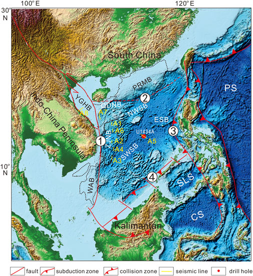
FIGURE 1. Regional tectonic background of the Zhongjiannan Basin, South China Sea YGHB- Yinggehai Basin, PRMB- Pearl River Mouth Basin, QDNB- Qiongdongnan Basin, ZJNB- Zhongjiannan Basin, WAB- Wan ‘an Basin, NWSB- northwest subbasin of SCS, SWSB- Southwest Subbasin of SCS, ESB- East Subbasin of SCS, SLS- Sulu Sea, CS- Celebes Sea, PS- Philippine Sea: (1)- Combined belt of Western SCS, including RRF in the north, WEFSCS in center and Wan ‘an Fault in the south, (2)- Combined belt of Northern SCS, namely, Qiongnan suture zone, (3)- subduction-collision zone of Eastern SCS, (4)- Subduction collision zone of SCS.
A structural pattern of alternating uplift and depression as well as faults, folds and unconformity interfaces developed in the basin. Five sets of strata were developed, namely, Holocene—Pliocene, Upper Miocene, Middle Miocene—Lower Miocene, Oligocene—Upper Eocene, and Middle Eocene—Paleocene (Gao et al., 2000; Chen and Zhong, 2008). The Cenozoic sedimentary formations are 2000–11,000 m thick. According to the seismic reflection characteristics of the unconformity interface and the regional seismic sequence division scheme, eight obvious seismic reflection interfaces, T1, T2, T3, T5, T6, T7, T8, and Tg, can be recognized in the Zhongjiannan Basin (Qiu et al., 1997; Zhong and Gao, 2005). Among them, Tg is the initial continental margin rifting and basement interface of the basin, T7 and T6 is the South China Sea breakup unconformity, T7 representing continental margin breaking and the beginning of seafloor spreading, T6 corresponds to the tectonic event of oceanic ridge jumping, and T5 is the unconformity interface formed at the end of seafloor spreading. T3 corresponds to the tectonic transition surface of important regional plate recombination events and rapid global sea level decline. Based on the comparison of drilling data and seismic data (Fyhn et al., 2009; Fyhn et al., 2013), it is determined that the age of the unconformity interface is 11.6 Ma, which is the interface between the middle Miocene and Late Miocene. This paper mainly studies the tectonic dynamics of sedimentary-structure evolution above the T3 interface (since the late Miocene) in the Zhongjiannan Basin.
The 2D seismic data used in this paper are all measured data from the marine survey conducted in Zhongjiannan Basin by the Guangzhou Marine Geological Survey. The 2D seismic data were collected in 2001, with 240 tracks and 30 coverage times, a distance of 50 m between shot points and a recording length of 9 s. The acquisition ship was the Tanbao ship, with a density of 32 km × 32 km and a distance of 4 km between velocity spectral points. The seismic data were reprocessed in 2013, with a distance of 1 km between velocity spectral points. In this way, the quality of seismic data can be improved to the maximum extent, and the sedimentary stratigraphic structure and tectonic reflection characteristics can be displayed more clearly from their recognition at shallow depths.
In the Zhongjiannan Basin, the reflecting interface between the Middle Miocene and late Miocene (T3) is a regional unconformity interface that can be traced throughout the basin and represents a transition from slow to rapid subsidence. The sedimentary-structure features above the T3 interface can be divided into three sections: south, middle and north.
The stratigraphic development of the southern section of the Zhongjiannan Basin is relatively complete. The seismic reflection characteristics are parallel or subparallel, indicating that the tectonic activity was weak, the sedimentary was stable, and the fault structure did not develop during the early deposition. However, due to the influence of magma intrusion and upwelling in the later period, the seamount emerged more, a large amount of magma formed horizontal compression on the stratum, and the stratum was arched at the seamount, showing an inclined shape and partial deflection deformation. The magmatic activity and incline and bending deformation of the strata mainly occurred in the southern uplift zone but weakened to the north (Figure 2).
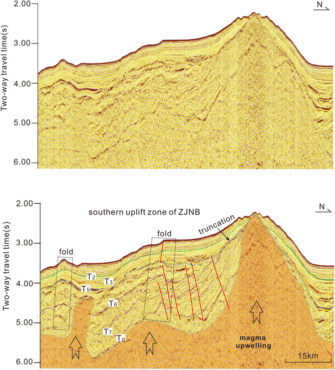
FIGURE 2. Sedimentary-structure development characteristics in the northern Zhongjiannan Basin (See line A1 in Figure 1 for profile location).
In the middle Zhongjiannan Basin (middle section), the seismic reflection characteristics show parallel continuous reflection above the T3 interface, which shows that the formation retains the original sedimentary characteristics. Fault and fold structures are few, and the overall tectonic activity is weak. In addition to the northern central depression affected by magma upwelling, the rest is characterized by stable sedimentary characteristics (Figure 3).
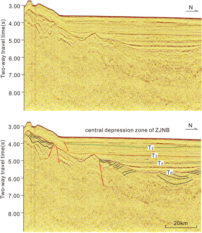
FIGURE 3. Sedimentary-structure development characteristics in the central Zhongjiannan Basin (See line A2 in Figure 1 for profile location).
The sedimentary structure above the T3 interface in the northern section of the Zhongjiannan Basin is relatively complex and can be roughly divided into three layers (Figure 4). The seismic reflection of the bottom layer (T3–T32) is parallel and continuous, reflecting stable sedimentary characteristics without folding deformation and indicating that it was not affected by tectonic activity. The seismic reflection of the middle layer (T32-T2) is disorderly, and the seismic reflection interface is discontinuous and inclined or curved, indicating that the stratum is damaged and that the tectonic activity is intense. From the characteristics of the disorderly seismic reflection, tectonic activity occurred when the strata were not consolidated diagenesis, so it can be inferred that tectonic activity and deposition occurred simultaneously. The seismic reflection interface of the upper layer (above T2) is relatively continuous, but most of it is inclined and curved, reflecting that although the tectonic activity is weaker than that of the middle layer, it has continued until now, and there are still folds and faults in local areas (Figure 4).
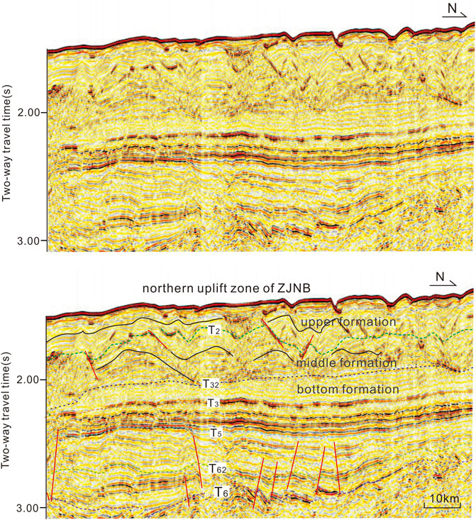
FIGURE 4. Sedimentary-structure development characteristics in the southern Zhongjiannan Basin (See line A3 in Figure 1 for profile location).
Sedimentary and structural development in the southern Zhongjiannan Basin shows that sequence stratigraphy developed stably since the late Miocene, but later influenced by magma upwelling, the stratigraphy became tilted and bent. From the formation development and structure analysis, the formation deformation caused by these magmatic activities is a long process, and the early strata (below T3) do not show obvious synsedimentary folds, indicating weak magmatic activities before the late Miocene. The strata below T3 have the characteristics of cutting (Figure 2), and the upper strata (above T3) have the phenomenon of overpassing near seamounts, indicating relatively strong magmatic activity after T3 (since Pliocene). Some magmatic rocks directly reach the seafloor to form seamounts (Figure 2), indicating that the activity has continued until now. Because the southern Zhongjiannan Basin is close to the SWSB and the magmatism in Zhongjiannan Basin weakens from south to north, we infer that these magmatic activities are from the residual magmatic activities of the SWSB after seafloor spreading (Li et al., 2014; Li et al., 2015; Sun et al., 2019b; Sun et al., 2021). By further comparing the seismic section passing through the spreading center of the SWSB (Figure 5), it is found that the development and structural characteristics of the strata above the T3 interface in the southern Zhongjiannan Basin are very similar to those of the SWSB, which were deformed by the uplift of the magma in the late stage (Figure 5). This further confirms that the tectonic dynamics in the southern Zhongjiannan Basin since the late Miocene are mainly derived from the residual magmatic activity of the SWSB. In addition, the magmatic activity was weak in the early Miocene (before the late Miocene) and strong in the late Miocene (since the late Miocene), which may be related to the supply of deep magma. These magmatic activities intruded into the bottom of the strata, resulting in compressional inclined or bending deformation of the strata, which was strong near the SWSB and gradually weakened to the north, so that the central (central depression) and northern Zhongjiannan Basin were basically unaffected.
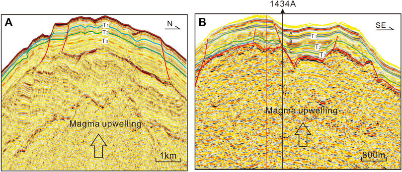
FIGURE 5. Seismic reflection characteristics between the Zhongjiannan Basin (A) and the U1434A drill of the SWSB (B).The position of profile a is shown in Box e in Figure 2A. The position of profile b can be seen along survey Line A2 in Figure 1.
The structural characteristics above the T3 interface in the northern Zhongjiannan Basin are significantly different from those in the central and southern basins, showing that the middle and upper strata (above T32) have experienced strong tectonic activity and that the strata have been severely damaged (Figure 4). Due to the stable development and weak tectonic activity of the strata above the T3 interface in the middle of the Zhongjiannan Basin, the dynamics cannot come from the south. Combined with the analysis of regional tectonic movement during this period, we speculate that it is probably related to the dextral strike-slip movement of the Red River Fault zone in the north.
At the end of the Mesozoic, the Indian plate subducted into the Eurasian plate, resulting in the formation of the Himalayan orogenic belt and Tibetan Plateau, as well as the Indochina Peninsula extruding southward along the Ailaoshan-Red River Fault Zone (Tapponnier et al., 1986; Tapponnier et al., 1990; Briais et al., 1993; Cao et al., 2017). The Red River fault zone extends from northwest Yunnan to the SCS (Tapponnier et al., 1986; Rangin et al., 1995; Liu et al., 2015b). The fault zone has the characteristics of segmented activity in space and is characterized by early sinistral strike-slip movement and late dextral strike-slip movement over time (Trinh et al., 2012; Cai et al., 2019). At present, there are two scientific controversies concerning the RRF that have become research hotspots in earth science (Cao et al., 2011; Liu et al., 2012; Liu et al., 2015a; Cao et al., 2017). One is the starting time of dextral strip-slip movement of the RRF, which is 17 Ma (Tapponnier et al., 1990; Gilley et al., 2003), 8 Ma (Xiang et al., 2004, 2006), and 5 Ma (Leloup et al., 1993; Leloup et al., 1995; Leloup et al., 2001). The other is that the junction position and their relationship between the RRF and WEFSCS in the western SCS are still uncertain.
According to the reflection characteristics of the seismic section in the northern Zhongjiannan Basin, the formation above the T32 interface had a greater influence by the extrusion stress field, and the seismic reflection characteristics show clutter reflection, which reflects that tectonic activity occurred in unconsolidated rock and that tectonism and sedimentation occurred at the same time (Figure 4). Calculating the position of sedimentary thickness and the structural layer, we speculate that the earliest time of tectonic activity is 7–8 Ma, but the exact age is subject to subsequent drilling dating. This is the sedimentary-structure response of the dextral strike-slip of the RRF in the northern Zhongjiannan Basin. According to the location of the folds in the section (Figure 6), the junction position of the RRF and WEFSCS can be confirmed. The cut-off point is in the position between the central seismic section and northern seismic section. At the junction position, the top seismic section shows that there is an obvious fracture trace, and there is also a deep large fault, which should be the transition zone between the RRF and WEFSCS. By measuring the junction position in this section (Figure 6) and in the western SCS (Figure 1), the junction position between the RRF and WEFSCS can be determined for the sea area of N15.5°. North of N15.5° is the influence region of the RRF, and to the south is the influence region of the WEFSCS, they are independent fault systems of each other since the late Miocene. The dextral strike-slip RRF affecting the formation only in the northern Zhongjiannan Basin is characterized by the formation of extrusion deformation and does not affect the formation in the central Zhongjiannan Basin. In other words, the WEFSCS has not experienced dextral strike-slip along with the RRF since 7–8 Ma.
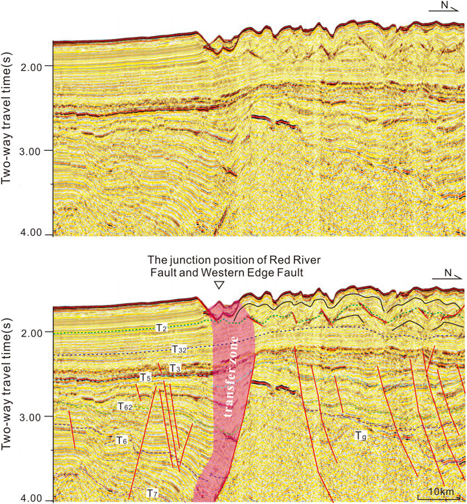
FIGURE 6. The junction position of RRF and WEFSCS in seismic section. The position of profile can be seen survey line A6 in Figure 1.
We tracked the characteristics of the seismic profile in the Qiongdongnan Basin and Yinggehai Basin near the RRF (Figure 7) and discovered that the formation development and structural deformation characteristics are similar to those in the northern Zhongjiannan Basin since the late Miocene, which further confirms that the tectonic dynamics of the northern Zhongjiannan Basin came from the dextral strike-slip movement of the RRF since the late Miocene.
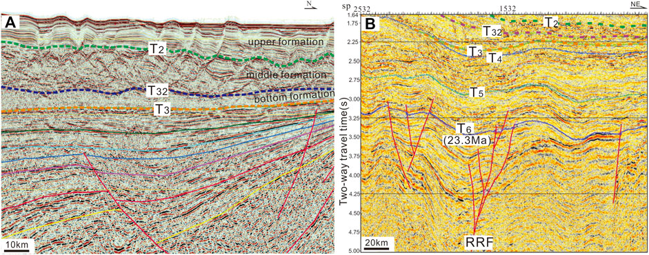
FIGURE 7. Seismic reflection sections of the Huaguang Sag of the Qiongdongnan Basin (A) and Yinggehai Basin (B), cited by Liu et al, 2015a. Note: The locations of Sections a and b are shown Lines A7 and A8 in Figure 1, respectively.
The tectonic dynamic environments of the Zhongjiannan Basin before and since the late Miocene are completely different. Before the late Miocene, affected by Indosinian Block extrusion in the southwest direction, the RRF and WEFSCS experienced sinistral strike-slip movement together. With the seafloor spreading of the SWSB, the Zhongjiannan Basin was controlled by an extensional stress field in the N‒S direction, and a strike-slip-pull-apart basin was formed with alternations between uplift and depression (Figure 8A). The Zhongjiannan Basin has been affected by two distinct tectonic dynamic environments since the late Miocene. The southern basin was mainly affected by residual magmatic activity after the expansion of the SWSB stopped. Due to magma upwelling, the Zhongjiannan Basin folds and bends, and the tectonic stress field gradually weakens from south to north, while the central Zhongjiannan Basin is basically unaffected. The northern Zhongjinan Basin was mainly affected by dextral strike-slip movement of the RRF, and the formation above the T32 interface experienced strong folding and deformation. Sedimentary-structural features recorded that the dextral movement of the RRF occurred at 7–8 Ma and lasted until now but gradually weakened after the T2 interface (approximately 5 Ma) (Figure 8B). The WEFSCS did not follow the dextral strike-slip movement of the RRF. According to the deformation range of stratigraphic folds caused by the dextral strike-slip of the RRF, the junction position of the RRF and the WEFSCS can be determined, which is approximately N15.5°(Figure 8C).
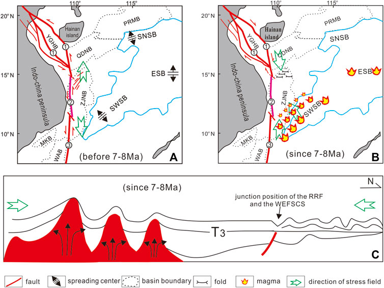
FIGURE 8. Tectonic dynamics model of the Zhongjiannan Basin before and after the late Miocene. YGHB- Yinggehai Basin, PRMB- Pearl River Mouth Basin, QDNB- Qiongdongnan Basin, ZJNB- Zhongjiannan Basin, WAB- Wan ‘an Basin, NWSB- northwest subbasin, SWSB- southwest subbasin, ①-RRF, ②-WEFSCS, ③-Wan `an Fault. (A) Tectonic setting and stress field orientation of Zhongjiannan Basin before the late Miocene. (B) Tectonic setting and stress field orientation of Zhongjiannan Basin after the late Miocene. (C) Structural model of the S-N profile in the western South China Sea after the late Miocene.
1. There have been different sedimentary-structure characteristics in the south, middle and north of Zhongjiannan Basin since the late Miocene. Under the influence of magmatism, the formation in the southern basin was uplifted, tilted and deformed locally. The middle formation is stable, and the tectonic activity is weak. In the northern basin, a strong compressional structure occurred, and the formation was damaged or folded.
2. The Zhongjiannan Basin has been affected by two tectonic dynamics since the late Miocene. In the south, it was affected by residual magmatic activity after the expansion of the SWSB stopped, forming longitudinal uplift and a transverse compressive tectonic stress field, which gradually weakened from south to north. In the north, the tectonic activity was weak, and the deposition was stable at the early stage (T3-T32), but during the late stage (above T32), the compressional tectonic stress field was formed under the influence of the dextral strike-slip movement of the RRF, which has lasted until now.
3. The sedimentary-structure characteristics of the Zhongjiannan Basin since the late Miocene reveal that the dextral strike-slip movement of the RRF occurred at 7–8 Ma, and the junction position between the RRF and WEFSCS is approximately N15.5°.
The original contributions presented in the study are included in the article, further inquiries can be directed to the corresponding author.
YZ, Writing, Data curation, Idea CZ, Idea, Writing, Reviewing and Editing YY, Data curation, Idea, Editing HQ, Graph drawing LZ, Graph drawing.
This research was funded by National Natural Science Foundation of China (No. U20A20100, No. 41206035, No. 42106079) and Nature Science Foundation of Guangdong Province (No. 2015A030313157, No. 2107A030312002, 2018A030313168). Special Project for Introduced Talents Team of Southern Marine Science and Engineering Guangdong Laboratory (Guangzhou) (Grant No. GML2019ZD0201). National Marine and land mineral resources map compilation and update project (No.DD20190368). The geophysical data in this paper are from Guangzhou Marine Geological Survey.
We are grateful to the reviewers and scientific editors for their very careful reviews and constructive suggestions, which greatly enhanced the scientific and technical level of the paper.
The authors declare that the research was conducted in the absence of any commercial or financial relationships that could be construed as a potential conflict of interest.
All claims expressed in this article are solely those of the authors and do not necessarily represent those of their affiliated organizations, or those of the publisher, the editors and the reviewers. Any product that may be evaluated in this article, or claim that may be made by its manufacturer, is not guaranteed or endorsed by the publisher.
Allen, C. R., Gillespie, A. R., Yuan, H., Sieh, K. E., Zhu, B., and Zhu, C. (1984). Red River and associated faults, Yunnan Province, China: Quaternary geology, slip rates, and seismic hazard. Geol. Soc. Am. Bull. 95, 686–700. doi:10.1130/0016-7606(1984)95<686:RRAAFY>2.0.CO;2
Briais, A., Patriat, P., and Tapponnier, P. (1993). Updated interpretation of magnetic anomalies and seafloor spreading stages in the south China Sea: Implications for the Tertiary tectonics of Southeast Asia. J. Geophys. Res. 98 (B4), 6299–6328. doi:10.1029/92JB02280
Cai, G. F. (2014). Cenozoic evolution of western basins in the South China Sea and its tectonic implication. Shanghai: Tongji University. [Dissertation].
Cai, Z. R., Lu, L. J., Huang, Qiangtai, Li, Jianfeng, Zhong, Lifeng, Xiang, Junyang, et al. (2019). Formation conditions for nanoparticles in a fault zone and their role in fault sliding. Tectonics 38, 159–175. doi:10.1029/2018TC005171
Cai, Z. R., Xia, B., Lü, B. F., Yao, W. Q., and Li, J. F. (2015). Initial rifting process and dynamics mechanism of Huaguang Sag: Evidence from a numerical modeling method. J. Earth Sci. 25 (6), 399–406. doi:10.1007/s12583-014-0502-y
Cao, S., Neubauer, F., Liu, J., Bernroider, M., Cheng, X., Li, J., et al. (2017). Rheological weakening of high-grade mylonites during low-temperature retrogression: The exhumed continental Ailao Shan-Red River fault zone, SE Asia. J. Asian Earth Sci. 139, 40–60. doi:10.1016/j.jseaes.2016.10.002
Cao, S. Y., Liu, J. L., Leiss, B., Vollbrecht, A., Genser, J., Neubauer, F., et al. (2011). Initiation of left-lateral deformation along the ailao Shan-Red River shear zone: New microstructural, textural and geochronological constraints from the Diancang Shan metamorphic massif, SW Yunnan, China. Int. Geol. Rev. 54, 348–367. doi:10.1080/00206814.2010.543789
Chen, L., and Zhong, G. J. (2008). Seismic stratigraphic analysis of Zhongjiannan Basin in south China sea. Geophys. Prospect. Petroleum 47 (6), 609–616. doi:10.1016/S1876-3804(08)60015-4
Fyhn, M. B. W., Boldreel, L. O., and Nielsen, L. H. (2009). Geological development of the central and south Vietnamese margin: Implications for the establishment of The south China sea, Indochinese escape tectonics and Cenozoic volcanism. Tectonophysics 478, 184–214. doi:10.1016/j.tecto.2009.08.002
Fyhn, Michael B. W., Lars, O. Boldreel, Lars, H. Nielsen, Tran, C. Giang, Le, H. Nga, Nguyen, T. M. Hong, et al. (2013). Carbonate Platform Growth and Demise offshore central Vietnam: Effects of early Miocene Transgression and subsequent Onshore uplift. J. Asian Earth Sci. 76 (20), 152–168. doi:10.1016/j.jseaes.2013.02.023
Gao, H. F., Bai, Z. L., and Guo, Y. Q. (2000). Cenozoic sedimentary facies and palaeogeographic evolution of Zhongjiannan basin, South China Sea. China Offshore Oil Gas Geol. 14 (6), 46–51.
Gilley, L. D., Harrison, T. M., Leloup, P. H., Ryerson, F. J., Lovera, O. M., and Wang, J. H. (2003). Direct dating of left-lateral deformation along the Red River shear zone, China and Vietnam. J. Geophys. Res. 108 (B2), 2127. doi:10.1029/2001JB001726
Lei, C., Ren, J. Y., Pei, J. X., Liu, B. W., Zuo, X., Liu, J. A., et al. (2021). Tectonics of the offshore Red River fault recorded in the junction of the Yinggehai and Qiongdongnan basins. Sci. China Earth Sci. 64 (11), 1893–1908. doi:10.1007/s11430-020-9796-2
Leloup, H. P., Lacassin, R., Tapponnier, P., Schärer, U., Zhong, D. L., Liu, X. H., et al. (1995). The ailao Shan - Red River shear zone (Yunnan, China), Tertiary transform boundary of Indochina. Tectonophysics 251 (1-4), 3–84. doi:10.1016/0040-1951(95)00070-4
Leloup, P. H., Arnaud, N., Lacassin, R., Kienast, J. R., Harrison, T. M., Phan Trong, T. T., et al. (2001). New constraints on the structure, thermochronology, and timing of the Ailao Shan-Red River shear zone, SE Asia. J. Geophys. Res. 106, 6683–6732. doi:10.1029/2000JB900322
LeLoup, P. H., Harrison, T. M., Ryerson, F. J., Chen, W. J., Li, Q., Tapponnier, P., et al. (1993). Structural, petrological and thermal evolution of a Tertiary ductile strike-slip shear zone, Diancang Shan, Yunnan. J. Geophys. Res. 98 (B4), 6715–6743. doi:10.1029/92JB02791
Li, C. F., Li, J. B., Ding, W. W., Franke, D., Yao, Y. J., Shi, H. S., et al. (2015). Seismic stratigraphy of the central South China Sea basin and implications for neotectonics. J. Geophys. Res. Solid Earth 120 (3), 1377–1399. doi:10.1002/2014jb011686
Li, C. F., Xu, X., Lin, J., Sun, Z., Zhu, J., Yao, Y. J., et al. (2014). Ages and magnetic structures of the South China Sea constrained by deep tow magnetic surveys and IODP Expedition 349. Geochem. Geophys. Geosyst. 15 (12), 4958–4983. doi:10.1002/2014gc005567
Liu, H. L., Yao, Y. J., Shen, B. Y., Cai, Z. R., Zhang, Z. W., Xu, H. H., et al. (2015a). On the Linkage of the western boundary faults of The south China sea. Eart. Scie. 40 (4), 615–632. doi:10.3799/dqkx.2015.049
Liu, J. L., Chen, X. Y., Wu, W. B., Tang, Y., Tran, M. D., Nguyen, Q. L., et al. (2015b). New tectono-geochronological constraints on timing of shearing along the Ailao Shan-Red River shear zone: Implications for Genesis of Ailao Shan gold mineralization. J. Asian Earth Sci. 103, 70–86. doi:10.1016/j.jseaes.2014.11.006
Liu, J. L., Tang, Y., Tran, M. D., Cao, S. Y., Zhao, L., Zhang, Z. C., et al. (2012). The nature of the Ailao Shan–Red River (ASRR) shear zone: Constraints from structural, microstructural and fabric analyses of metamorphic rocks from the Diancang Shan, Ailao Shan and Day Nui Con Voi massifs. J. Asian Earth Sci. 47, 231–251. doi:10.1016/j.jseaes.2011.10.020
Nguyen, V. V., and Hoai, L. T. T. (2019). Cenozoic paleostress evolution in south central Vietnam: Implication for changing dynamics of faulting along the eastern Indochina continental margin. J. Asian Earth Sci. 185, 104006. doi:10.1016/j.jseaes.2019.104006
Qiu, Y., Yao, B. C., Li, T. G., Bao, C. W., Gong, Y. H., and Zhong, H. X. (1997). Geologic and tectionc features and hydrocarbon potential of the Zhongjianan basin, South China Sea. Geol. Res. South China Sea 9, 37–53.
Rangin, C., Klein, M., Roques, D., Le Pichon, X., Van Trong, , and Le, (1995). The Red River fault system in the Tonkin Gulf, Vietnam. Tectonophysics 243 (3 - 4), 209–222. doi:10.1016/0040-1951(94)00207-p
Replumaz, A., Lacassin, R., Tapponnier, P., and Leloup, P. H. (2001). Large river offsets and Plio-Quaternary dextral slip rate on the Red River fault (Yunnan, China). J. Geophys. Res. 106, 819–836. doi:10.1029/2000jb900135
Schoenbohm, L. M., Burchfiel, B. C., Chen, L. Z., and Yin, J. Y. (2005). Exhumation of the Ailao Shan shear zone recorded by Cenozoic sedimentary rocks, Yunnan Province, China. Tectonics 24 (6), TC6015. doi:10.1029/2005tc001803
Schoenbohm, L. M., Burchfiel, B. C., Chen, L. Z., and Yin, J. Y. (2006). Miocene to present activity along the Red River fault, China, in the context of continental extrusion, upper-crustal rotation, and lowercrustal flow. Geol. Soc. Am. Bull. 118, 672–688. doi:10.1130/b25816.1
Sun, Z., Ding, W. W., Zhao, X. X., Qiu, N., Lin, J., and Li, C. F. (2019a). The latest spreading periods of The South China sea: New constraints from macrostructure analysis of IODP expedition 349 cores and geophysical data. J. Geophys. Res. Solid Earth 124 (10), 9980–9998. doi:10.1029/2019JB017584
Sun, Z., Li, F. C., Lin, J., Sun, L. T., Pang, X., and Zheng, J. Y. (2021). The rifting-breakup process of the passive continental margin and its relationship with magmatism: The attribution of The south China sea. Earth Sci. 46 (3), 770–789. doi:10.3799/dqkx.2020.371
Sun, Z., Lin, J., Qiu, N., Jian, Z. M., Wang, P. X., Pang, X., et al. (2019b). The role of magmatism in the thinning and breakup of the South China Sea continental margin. Natl. Sci. Rev. 6 (05), 871–876. doi:10.1093/nsr/nwz116
Sun, Z., Zhou, D., Zhong, Z. H., Zeng, Z. X., and Wu, S. M. (2003). Experimental evidence for the dynamics of the formation of the Yinggehai basin, NW South China Sea. Tectonophysics 372, 41–58. doi:10.1016/s0040-1951(03)00230-0
Tapponnier, P., Lacassin, R., Leloup, P. H., Schärer, U., Zhong, D. L., Wu, H. W., et al. (1990). The ailao Shan/Red River metamorphic belt: Tertiary left-lateral shear between Indochina and south China. Nature 343, 431–437. doi:10.1038/343431a0
Tapponnier, P., Peltzer, G., and Armijo, R. (1986). On the mechanics of the collision between India and Asia. Geol. Soc. Lond. Special Publ. 19 (1), 113–157. doi:10.1144/gsl.sp.1986.019.01.07
Trinh, P. T., Liem, N. V., Huong, N. V., Vinh, H. Q., Thom, B. V., Thao, B. T., et al. (2012). Late Quaternary tectonics and seismotectonics along the Red River Fault zone, north Vietnam. Earth. Sci. Rev. 114, 224–235. doi:10.1016/j.earscirev.2012.06.008
Xiang, H, F., Wan, J. L., Han, Z. J., Guo, S. M., Zhang, W. X., Chen, L. C., et al. (2006). Geological analysis and FT dating of large dextral strike-slip movement in Red River Fault Zone. Science in China ser. D. earth Sci. 36 (11), 977–987.
Xiang, H. F., Han, Z. J., Guo, S. M., Zhang, W. X., and Chen, L. C. (2004). large-scale dextral strike-slip movement and asociated tectonic deformation along the Red River Fault Zone. Seismol. Geol. 26 (4), 598–610.
Yin, Z. X., Cai, Z. R., Wan, Z. F., and Lv, B. F. (2015). Features and dynamic mechanisms of Cenozoic tectonic migration and its impact on the hydrocarbon accumulation in the northern South China Sea. Acta Oceanol. Sin. 34 (1), 100–109. doi:10.1007/s13131-015-0603-1
Zhang, C. M., Sun, Z., Manatschal, G., Pang, X., Li, S. Z., Sauter, D., et al. (2021). Ocean-continent transition architecture and breakup mechanism at the mid-northern South China Sea. Earth-Science Rev. 217 (3), 103620. doi:10.1016/j.earscirev.2021.103620
Zhong, G. J., and Gao, H. F. (2005). Sequence characteristics of Cenozoic stratigraphy in Zhongjiannan Basin, south China sea. Geotect. Metallogenia 29 (3), 403–409.
Zhu, W. L., and Lei, C. (2013). Refining the model of South China Sea's tectonic evolution: Evidence from Yinggehai-Song Hong and Qiongdongnan basins. Mar. Geophys. Res. 34 (3-4), 325–339. doi:10.1007/s11001-013-9202-8
Keywords: Zhongjiannan Basin, late Miocene, tectonic dynamics, Red River Fault (RRF), West Edge Fault of the South China Sea (WEFSCS)
Citation: Yin Z, Cai Z, Yao Y, Huang Q and Li Z (2023) Tectonic dynamics of the Zhongjiannan Basin in the western South China Sea since the late Miocene. Front. Earth Sci. 10:996267. doi: 10.3389/feart.2022.996267
Received: 17 July 2022; Accepted: 15 September 2022;
Published: 06 January 2023.
Edited by:
Zhigang Li, Sun Yat-sen University, Zhuhai Campus, ChinaReviewed by:
Hongwei Yin, Nanjing University, ChinaCopyright © 2023 Yin, Cai, Yao, Huang and Li. This is an open-access article distributed under the terms of the Creative Commons Attribution License (CC BY). The use, distribution or reproduction in other forums is permitted, provided the original author(s) and the copyright owner(s) are credited and that the original publication in this journal is cited, in accordance with accepted academic practice. No use, distribution or reproduction is permitted which does not comply with these terms.
*Correspondence: Zhourong Cai, Y2FpemhyQG1haWwuc3lzdS5lZHUuY24=
Disclaimer: All claims expressed in this article are solely those of the authors and do not necessarily represent those of their affiliated organizations, or those of the publisher, the editors and the reviewers. Any product that may be evaluated in this article or claim that may be made by its manufacturer is not guaranteed or endorsed by the publisher.
Research integrity at Frontiers

Learn more about the work of our research integrity team to safeguard the quality of each article we publish.