 Shun Yang
 Huali Pan3
 Tao She
 Jiaxuan Jiao
95% of researchers rate our articles as excellent or good
Learn more about the work of our research integrity team to safeguard the quality of each article we publish.
Find out more
ORIGINAL RESEARCH article
Front. Earth Sci. , 17 August 2022
Sec. Geohazards and Georisks
Volume 10 - 2022 | https://doi.org/10.3389/feart.2022.989488
This article is part of the Research Topic Monitoring, Early Warning and Mitigation of Natural and Engineered Slopes – Volume II View all 17 articles
The upstream Fujiang River are famous for their high mountains and narrow canyons, which results in a conflict of interest between local residents and land use. To make good use of precious land resources is a meaningful work for local people and government. Therefore, field surveys and theoretical analysis were carried out in the upstream Fujiang River to explore the land-use evaluation and utilization advice. Firstly, we analyzed the factors which affect the land use of debris flow depositional area. Secondly, we chose the factors of soil fertility quality, soil particle conservation, and the geological engineering condition to set up the land-use evaluation method. Thirdly, through index classification, we give the planting type, land-use type, construction type respectively, according to grading and assignment value for each factor, we built the debris flow disaster-prone land utilization mode R by using an analytical hierarchy process method. Lastly, taking Huangjiaba village as an example, based on the debris flow disaster land-use evaluation method and debris flow hazard evaluation, we identified four land-use scenarios. The results show that the value of the four scenarios is between 1.00 and 4.00, the four scenarios utilization advices are given based on each R-value and Huangjiaba natural condition. It also obtained that the developmental tendencies of the debris flow disaster areas appear to deposit recently, the frequency of debris-flow activity is evolving from high to stable, on making good use of debris flow deposit fan’s usage is necessary to explore the disaster prone land and avoid disaster loss. Further studies need to systematically consider more factors to evaluate debris flow and disaster-prone land utilization, which can provide a reference for the rural space planning and revitalization for the local government.
Environmental Earth science constitutes the study of the natural world and its interaction with society (Siegert, 2016). Currently, land, as the carrier of all economic and social activities, appears increasingly scarce with ongoing socioeconomic development. Therefore, more attention has been paid to the remediation of disaster-destroyed land. Debris flows are widely distributed and a frequently occurring hazard in mountainous regions. Due, in part, to its high sand and clay content, huge areas of debris flow cause deposit fans to form before it runs into the main river (Gregoretti et al., 2016). It has been reported in over 70 countries in the world and often causes severe economic losses and human casualties, seriously retarding social and economic development (Imaizumi et al., 2006; Cui et al., 2009; Tecca and Genevois, 2009; Tiranti and Deangeli, 2015; Gregoretti et al., 2016; Hu et al., 2016). Presently, the relationship between the economic supply and social demand for land will further deepen the uncoordinated tension, in particular, the productive capacity of currently available land resources in ecologically fragile areas is likely to decrease, while the possibility of increases in quality or quantity is limited (Cui et al., 2011; He et al., 2018; He et al., 2020).
Currently, several kinds of “hard to use land” have been developed and utilized, such as desert land (Cao et al., 2018), mining wasteland (Liu et al., 2016), Loess land (Wang et al., 2022).) and karst land (Chen et al., 2017). Meanwhile, China faces the problem of accelerating urbanization in mountainous areas and needs to explore the use of new land, which requires further investigation and planning to achieve the rational allocation of new land resources (Liu, 2018). It is noteworthy that rational allocation refers to the land use type and the selection of suitable land types, for instance, flat and safe areas are developed into building land and cultivated land, and steep slope areas are developed into forest or grassland (Liu et al., 2022). In Lhasa River Basin, land suitable for settlement or living is experiencing a shortage of resources, alluvial fans have the potential to alleviate the problem, survey results showed that alluvial fans are important land resources in LRB and may have huge utilization potential (Chen et al., 2021). Abundant debris-flow deposits on land are widely distributed in mountainous areas. Currently, those areas have mainly been developed for crop cultivation, rural village construction, and tourism (Okunishi and Suwa, 2001; Sancho et al., 2008). To some extent, it is necessary for locals in mountainous regions to use those widely-distributed debris flow and disaster-prone landscapes for agricultural and house building because they are the only available lands that are essentially flat. Through statistical and field surveys, those areas appear gently flat and have abundant water supplies, which are the superior land source in mountainous areas, due to their high quality of heat and water condition. These areas offer promising development prospects. Therefore, making good use of debris flow depositional land represents the key method to develop the local economy and change the ecological environment, it can also balance the relationship between human needs and debris flow control.
Previous literature has found that the debris flow disaster-prone land research changed over time and began with a hazard risk evaluation and sedimentation events (Jakob and Hungr, 2005; He et al., 2016), then it shifted to natural protection and land use for damage reduction. Recently, it focused on land use and spatial planning, as He et al. (2018, 2019) analyzed land-use changes and their driving forces in the debris flow active area of Gansu and Yunnan province, China. Minimal attention has been paid to these areas compared to traditional land sources; thus, it is easy to neglect the function of debris flow disaster-prone fans in mountain development and engineering protection. Therefore, there is a need to improve the understanding of the debris flow depositional land. Generally, the debris flow waste fans are often distributed in the gully mouth, which is close to the main river and appears as relatively flat terrain. Therefore, those areas are a land type directly destroyed by debris flow and other geo-hazards (Qiu et al., 2022; Zhou et al., 2022). With field investigation and information queries, we found that local residents are usually undertaking agriculture, village, and road construction in those areas. In recent years, domestic and international scholars focused research related to debris flow deposits, which include the depositional characteristics, land-use classification and sedimentation processes, and the debris flow hazard zoning method (Ibe and Ebe, 2000; Liu et al., 2001; Okunishi and Suwa, 2001; Xu et al., 2001; Wang et al., 2018). Meanwhile, the debris flow disaster deposit area is the combination of a resource and disaster as its development has both positive and negative effects. To increase the economic benefits and decrease the hazardous impact, it is useful to undertake hazard zone research.
This research focuses on a small mountain watershed, exploring the evaluation of land resource utilization caused by debris flow disasters. The Fujaing River, central to this study, is a tributary of the Jialing River. Field survey and data analysis justified the urgency of summarizing the characteristics of the debris flow disaster-prone area in the Fujiang mountainous region. Generally, the debris flow deposit fans are the most important areas for local residents, a premise that has helped to attract much research attention from debris flow scholars. Along with the development of debris flow depositional land, it is helpful to change the ecological environment and support the local economy. Through field surveys and interviews with local residents, we find that many debris flow gullies from the upstream areas of the Fujiang River have frequently broken out as debris flows after the Wenchuan earthquake. Every gully could form debris flows during heavy rainfall in the rainy season, especially in the Nanba and old Beichuan districts. According to field surveys and debris flow statistics of the upstream Fujiang River, we found that the frequency of occurrence and scale of regional debris flows are gradually stabilizing. Thus, how to make good use of those areas, especially the potential debris flow, disaster-prone areas, is an extremely urgent and necessary topic of research. This research takes the upstream Fujiang River basin as an example based on the characteristics of regional debris flow depositional land to set up an evaluation method and then proposes advice for applying each land-use scenario.
The study area of the Fujiang River is almost 36,400 km2 in size. Its main river length is 670 km and it originates from Xuebaoding Mountain, Pingwu County, Sichuan Province. The Fujiang River flows across Pingwu, Jiangyou, Mianyang, Santai, Shehong, Suining, Tongguan, and lastly merges with the Jialing River in the Hechuan district, Chongqing. Among its characteristics, the geomorphology of the upstream Fujiang River is a typical alpine valley region, and the Longmen Fault traverses across the entire watershed from Beichuan County to Nanba town. On both sides of the fault, the mountain surface is crushed and the landform undulates dramatically based on the complex geological structure and frequent geotectonic movement. Debris flow, landslides, and rock falls are the main potential geological hazards in this region. While the geomorphology of the downstream areas of the Fujiang River consists of small plains and hills, which appear to be within a relatively stable regional geological environment, only a few minor landslips and water source pollution episodes constitute the main hazard problems along the bank side. Figure 1 illustrates the watershed which helps to infer the character of the disaster area. Field investigation points are also shown.
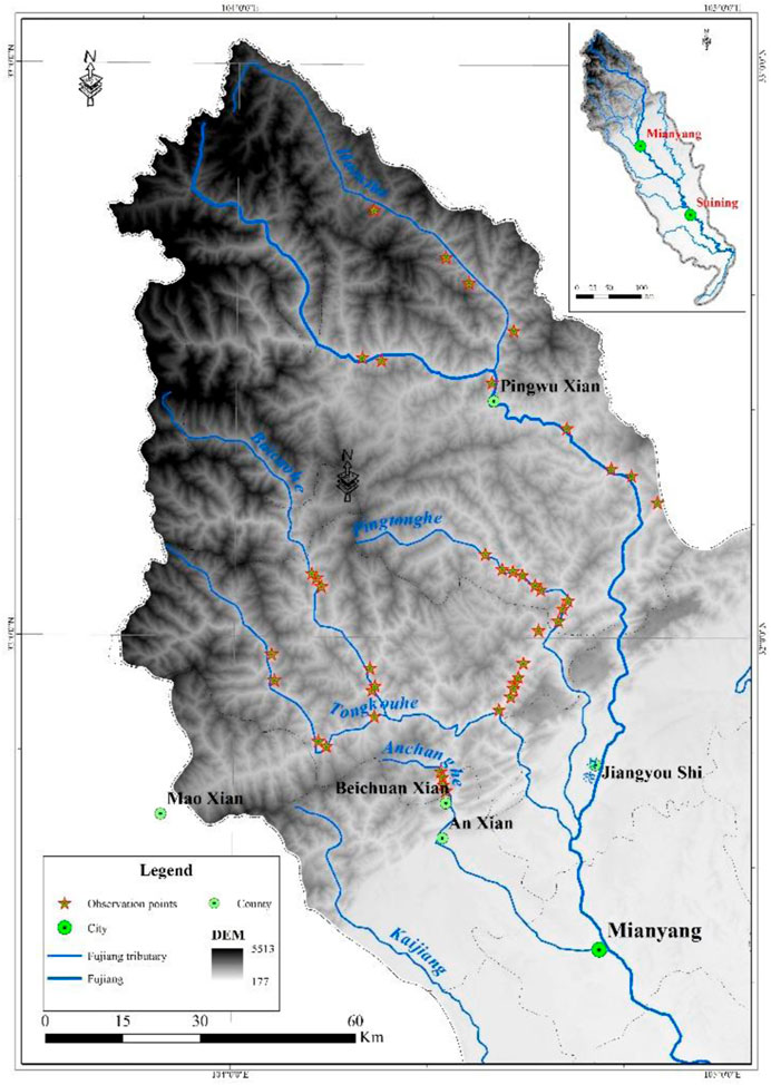
FIGURE 1. The field survey location of the Fujiang River upstream.
Statistical analysis outlines the development tendency of the debris flow disaster area (see Table 1).
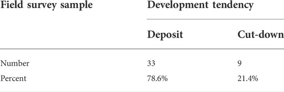
TABLE 1. The development tendency of debris flow disaster lands of Fujiang River upstream.
From Table 1, 9 investigation points appeared to show a cut-down tendency, which accounts for 21.4 percent, while the other 33 survey points show a deposit tendency, which accounts for 78.6 percent. Therefore, the debris flow deposits of the upstream Fujiang River are mainly characterized by deposition rather than cut-down, so far, which indicates that the debris flow occurrence transitions from a high susceptibility to a low susceptibility state, after the Wenchuan earthquake, indicative of a gradual stabilization.
Through literature review and sample lab tests, we learn that many factors affect the land use of debris flow depositional areas, such as the soil fertility quality, fine particle content, slope angle, engineering geological characteristics, and debris flow form condition, debris flow watershed, lithology, the height difference (Cui et al., 2008). The soil fertility quality factor can be assessed by soil nutrient index (organic content), total nitrogen, total phosphorus, and total potassium, the value can be attained by physical and chemical experiments. Additionally, fine particle content determines the soil texture, especially soil moisture, nutrient retention, and transport. The soil erosion ratio affects the debris flow depositional land-use type, which is the factor obtained from the numerous sample particle size analysis. Through engineering geological data references and in situ tests with proposed equipment in the debris flow depositional area, the bearing capacity of foundation soil can be obtained is between 100 and 260 kPa, which can be used to support a resident’s homestead or a factory foundation, the index can be obtained by in situ tests and laboratory strength tests. Therefore, we choose soil fertility quality, soil particle conservation, and engineering geological condition as the main factors to evaluate the land use of debris flow deposit fans. Based on the connotations of each factor, we expand upon the classification of the three factors.
Soil fertility is an important indicator that reflects the vegetative-supporting health of the soil. It represents the most essential characteristic of soil that distinguishes soil from parent material and other natural bodies. The soil nutrient classification standard mainly grades the contents of organic matter, total nitrogen, available nitrogen, available phosphorus, and available potassium, and each grade has different contents/proportions of different components. Organic materials are a key sign of soil fertility because of their abundance of botanical nutrients. According to the soil fertility evaluation model (Wang et al., 2003), using the single-factor analysis method, the soil organic matter content can be used as the land potential classification standard of debris flow deposit fans. According to the second national soil survey and related standards, the organic material content is divided into six levels. Based on the degree of soil fertility and properties of the particle distribution of debris flow depositional land, we can divide the four soil quality levels into good, quite well, ordinary, and bad according to its organic materials content. Through the grade of organic materials content, the soil quality is divided into four grades, and the planting type suggestion for the upstream Fujiang River can be seen in Table 2.
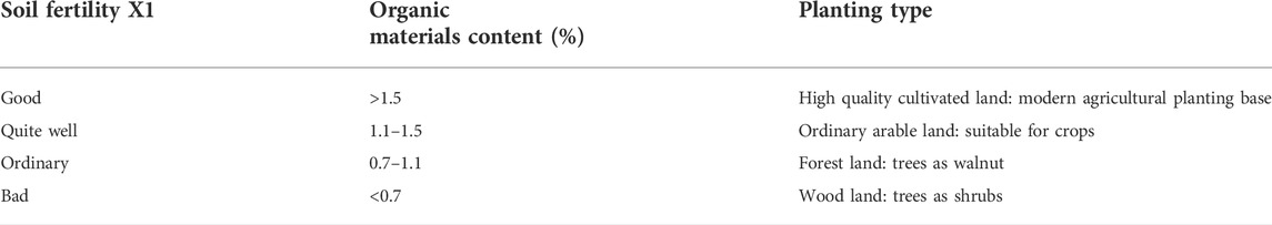
TABLE 2. The soil fertility grading and planting type.
Soil not only provides crops with nutrients, water, and air but the soil environment also affects the amount of nutrients and water absorbed by crops. Generally, debris flow deposits exhibit a wide gradation, especially from clay particles to large boulders, which are widely distributed in the depositional fans. Differing particle contents and concentrations profoundly affect the debris flow density, which determines the debris flow erosion capacity. Meanwhile, fine particle content determines the soil texture, especially affecting the soil moisture and nutrient retention and transport. The soil erosion ratio affects the debris flow depositional land-use type. Soil and water conservation is another key factor for a debris flow ravine. The fine particle content of debris flow depositional fans was determined by the loose solid materials in the source area, such as soil landslides and gully depositional materials. Nevertheless, the frequent floods in the gully also carried away large amounts of fine particulate matter. According to the classification of debris flow erosion ability, four levels represent the condition of the debris flow density determined by the fine particle content. Thus, the debris flow erosion capacity can be subdivided into four levels of soil conservation: good, quite well, ordinary, and bad. The water and soil erosion ratio can directly reflect upon the fine soil particle conservation. Therefore, based on the water and soil ratio and particle distribution, we obtain the soil conservation and land-use types given in Table 3.
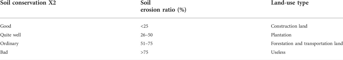
TABLE 3. The soil conservation classification and land use type.
Whether a house is safe and stable is closely related to the quality of the foundations. Soil can be divided into many types, such as sand, clay, boulder, and fill. In mountainous areas, debris flow deposit fans often physically support the living and producing platforms for local residents, and the engineering geological characteristics of debris flow in disaster-prone areas can directly affect local residential construction and production. The bearing capacity of the foundation soil is one of the most important factors because it can indicate the soil strength for debris flow in disaster-prone land. According to the field survey data collected in the upstream Fujiang river, the bearing capacity of foundation soil is commonly between 100 and 260 kPa in mountainous areas; the characteristic values of bearing capacities for clay, silt, sand, medium sand, and coarse sand pebbles are 120, 150, 170, 260, and 350 kPa, respectively. Therefore, the land gets its classification and construction type suggestion based on the bearing capacity of the foundation soil grade, as seen in Table 4.
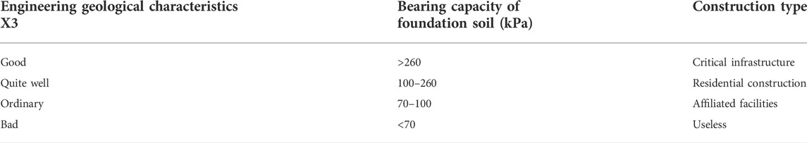
TABLE 4. The engineering geological characteristics and construction type.
Considering the land utilization factors ahead, we obtain the three classification factors in Table 5. For their evaluation, we set the four classification values to 4, 3, 2, and 1, respectively.
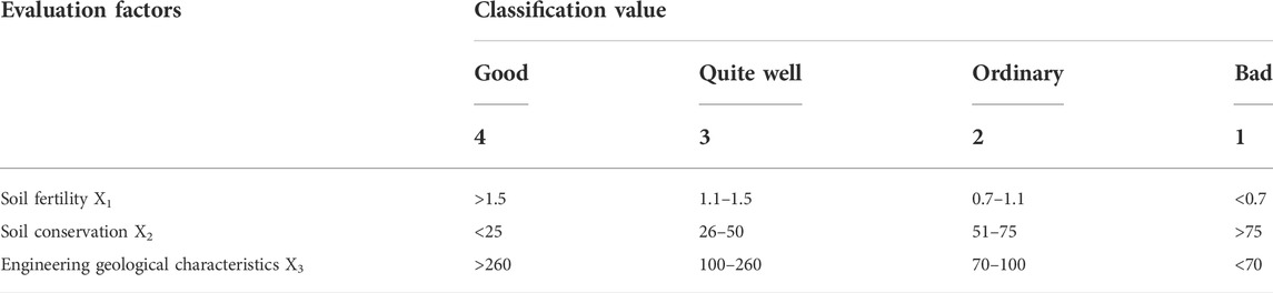
TABLE 5. The factors classification of land utilization.
The Analytic Hierarchy Process (AHP) is a decision analysis method that combines qualitative and quantitative methods. Using less quantitative information makes the thinking process of decision making less mathematical, to provide a simple decision-making method for multi-objective, multi-criteria, or complex decision issues without structural characteristics. When using the AHP to construct a system model, the process can be divided into four steps, setting up the hierarchy structure model, constructing a judgment matrix, conducting a hierarchical ranking, and testing for consistency. The debris flow land-use evaluation is the goal, and the soil fertility, soil conservation, and engineering geological characteristics represent the criteria for decision making. Therefore, to obtain the weight of the debris flow evaluation factors, matrix A is built as follows:
where A is the debris flow disaster land-use evaluation factor judgment matrix, W is the determined eigenvectors of matrix A, and n is an eigenvalue of A. Through an analytical hierarchy process, we obtain the sorting results, as seen in Table 6.
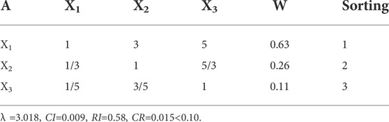
TABLE 6. The land utilization factors sorting and weight reference value.
From Table 6, the weighting coefficients X1, X2, and X3 are obtained, which are 0.63, 0.26, and 0.11, respectively. According to the verification of the maximum characteristic roots, we found it found that the three weighting coefficients are reasonable. Thus, the debris flow disaster utilization mode can be expressed by the following formula:.
where R is the debris flow disaster-prone land-use evaluation value.
From Eq. 2 and its factors classification, we can obtain the three levels for the debris flow disaster potential land use. These are low extent, medium extent, and high extent, respectively. Based on the evaluation factors, the interval evaluation values are 1.00–2.00, 2.00–3.00, and 3.00–4.00, accordingly.
Huangjiaba is a village along the Longmen Mountain Fault. Due to its flat depositional fans and proximity to the Jian River, many residents currently live here. In the upstream areas of Huangjiaba, steep gullies and drop ridges have developed, which provide powerful topographic conditions for the confluence and movement of debris flow. Meanwhile, numerous areas of rock fragmentation, collapse, and landslides develop and provide enough loose solid materials for debris flow. The symbiotic relationship between disasters and land resources determines the debris flow depositional land utilization. Taking the Huangjiaba village debris flows as an example, our method divides the area by hazard assessment first, probing the planting type by soil fertility. Then, together with engineering characteristics and other factors, we can get the potential land-use classification of the debris flow deposit-prone area.
Based on the debris flow disaster land-use evaluation method and the factor classification of potential soil use, we can learn that the entire Huangjiaba village debris flow disaster-prone areas are between 1.00 and 4.00, and each irregular district has a different R-value. Then, together with the current land-use type, we obtain the four land-use scenarios, R-values, and definition expressions as indicated in Table 7.
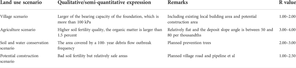
TABLE 7. Debris flow land use scenario introduction of Huangjiaba.
From Table 7, we see the four scenario values ranging from 1.00 to 4.00. Based on the scenario values and semi-quantitative analysis, it can be used to obtain the land-use scenario, as shown in Figure 2. Accordingly, the village scenario mainly focuses on the bearing capacity of the foundation. The irregular area overlaid by light blue includes the local, currently existing rural building area and future potential planning construction area. The agriculture scenario concentrates on the higher soil fertility quality, especially the flat areas, so the area covered by pale yellow generally indicates high soil fertility quality (such as organic matter), total phosphorus, and total nitrogen, and the flat area on the edge of the depositional fans, which are close to the Jian river. Soil and water conservation scenarios are mainly related to the debris flow hazard evaluation. The areas overlaid by light green are debris flow gullies on the depositional fans, especially the area moved by debris flow once in a 100-years return period. As for the potential construction scenario, those areas that show low soil fertility, but are relatively safe, are covered by pink color. In fact, the determination of boundaries is subject to many factors—such as rural homestead planning, soil fertility, debris flow path, and scale—so the four scenario boundaries in Figure 2 only show reference schematics.
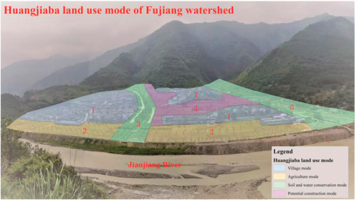
FIGURE 2. The diagram of Huangjiaba four land-use scenario.
Through the land-use scenarios to be mentioned ahead, we offer suggestions for each scenario as follows.
Village scenario: The existing building area can maintain its original status or be reconstructed according to village space planning. Other potential construction areas can be planned on a reasonable basis, depending on the soil capacity of the foundation and hazard risk assessment. Moreover, due to the low debris flow disaster risk of damaged land and that the land-use scenario can be flexibly planned, these regions are mainly used as resettlement homesteads, see Figure 3A.
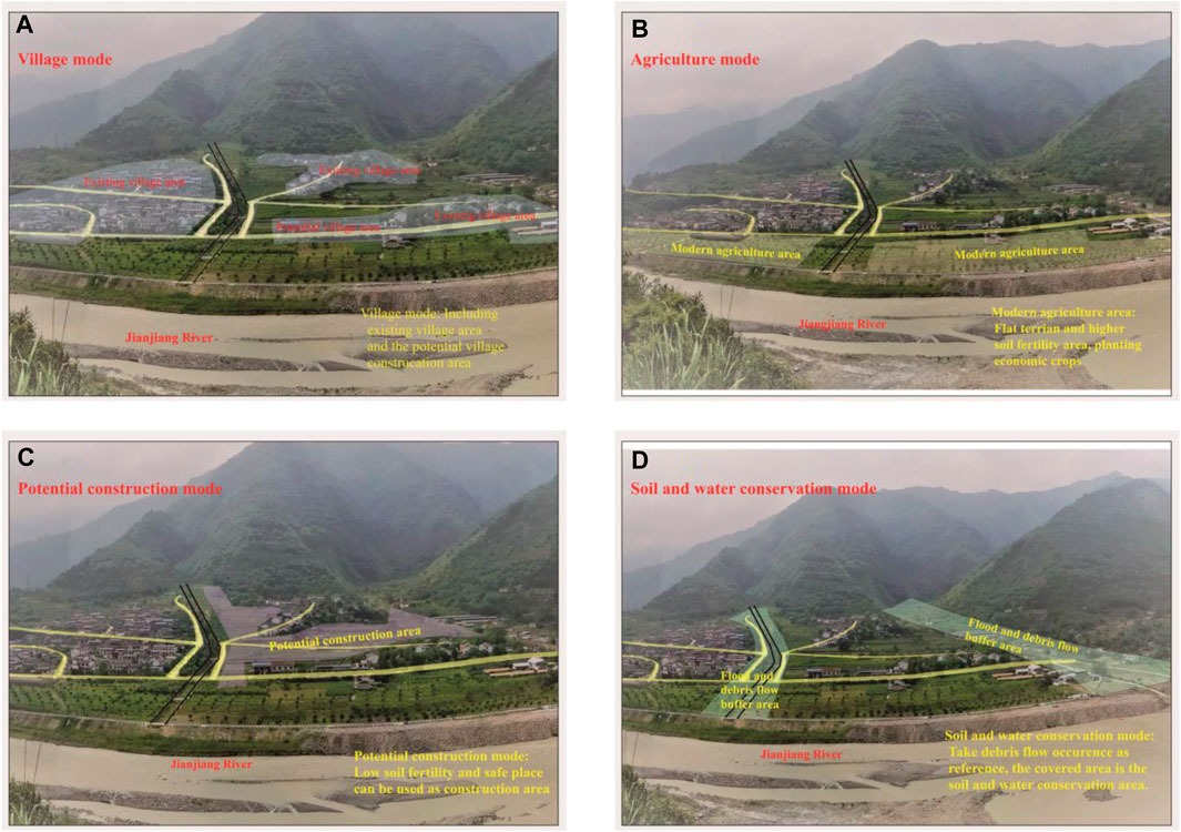
FIGURE 3. Huangjiaba debris flow disaster land-use scenario ((A) Village scenario (B) Agriculture scenario(C) Soil and water conservation scenario (D) Potential construction scenario).
Agriculture scenario: Through sample tests, we conclude that the soil fertility at the fan edge is superior, but due to its proximity to the Jian River, there is a high flooding risk. Therefore, it is advisable to set the fan edge as the economic crop area. In addition, considering the local precipitation pattern, seasonal vegetables can be planted below the village road. On the other areas of the fan edge, one can plant high-value economic crops such as Ginkgo, tea trees, greenhouse vegetables, and flowers, as seen in Figure 3B.
Soil and water conservation scenario: These areas mainly consist of flood and debris flow movement areas. The characteristics of the flood and debris flow hazard zone of a small watershed suggest fast-growing trees and shrubs can be planted along the overflow side of the ditch to enhance the resistance to disasters, while economic trees such as walnuts and cherries can be planted near the channel side. We took the submerged area of 100-, 50-, and 20-years occurrence frequency as examples, correspondingly, the debris flow break-out frequencies are 1%, 2%, and 5%, respectively. In the area covered by 1%–5% frequencies, ornamental trees can be planted, such as Ginkgo; in the 2%–5% areas, shrubbery can be planted, such as tea trees, and village roads set. Areas covered by 5% frequency can be fixed as debris flow channels, see Figure 3C.
Potential construction scenario: These areas are characterized by serious land and water erosion, mainly involving infrastructure, such as village roads, pipelines, factories, etc. We utilize the low soil fertility content and gently sloping terrain, especially if the slope angle is less than 10°, to build pig farms, chicken farms, sand mining factories, etc. These areas can also be created into water and soil conservation forests by a reasonable collocation of trees and shrubs, such as planting red leafy trees, Ginkgo biloba, flowers, shrubs, and other plants, as seen in Figure 3D.
Debris flow fan: Debris flow deposit areas mainly consist of loose solid materials transported from upstream areas. It is the most important living and producing location for residents. Through statistical analysis of the investigation points, we can characterize the integrity of the debris flow deposit fans, as seen in Figure 4.
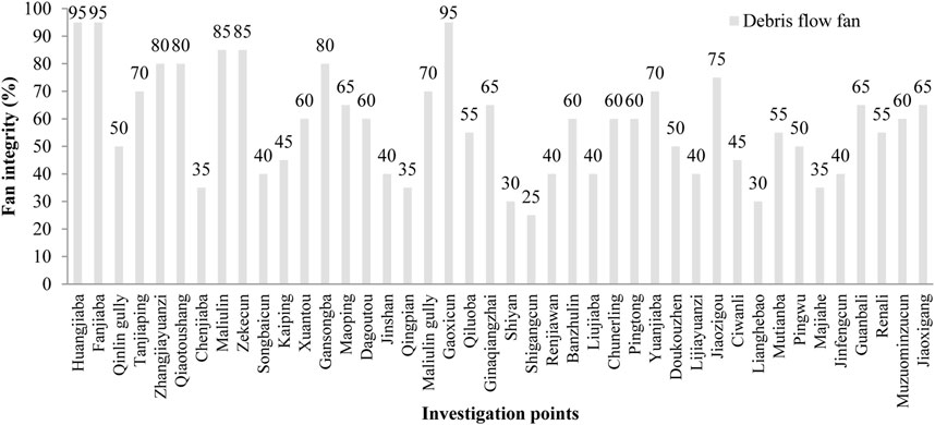
FIGURE 4. The disaster fans of the Fujiang River upstream.
From Figure 4, the integrity of debris flow deposit fans in the upstream Fujiang River is between 30 and 95%, with an average value of 58%. According to these statistics, there are four types of fan integrity in the upper Fujiang River, as seen in Table 8.
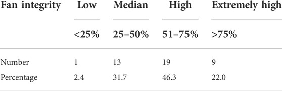
TABLE 8. The fans integrity classification of the Fujiang River upstream.
From Table 8, the low integrity of the debris flow disaster fan is found at only one point, which accounts for 2.4% of the 42 investigated points. Median integrity fans are found at 13 points, accounting for 31.7%, high integrity fans are found at 19 points, accounting for 46.3%, and extremely high integrity fans are found at nine points and account for 22% of all investigated points. Generally, the integrity type of the deposit fans is either high or median; therefore, these areas could be used for resident living and production places.
The distance from the river: The deposits of debris flows are mainly from the upper watershed and the gully sides, and the distance between the debris flow at the fan top and the main river could be a result of the activity intensity of the debris flow. Figure 5 shows the statistical analysis of the distance between the fan top and the main river.
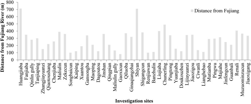
FIGURE 5. The distance of investigation sites from the main river in the Fujiang River upstream.
As seen in Figure 5, the direct length from the debris flow gully mouth to the Fujiang River is between 100 and 350 m; some special fans even reach 700 m, such as those in disaster-prone land, which is determined by the watershed and debris flow activity intensity. For example, the distance value between Huangjiaba and Shiyan reached more than 700 m. Huangjiaba is located along the left bank of Jianjiang River, where the debris flow area is more than 10 km2. The Longmen Mountain fault cuts across the upstream of the Huangjiaba debris flow source area. Due to frequent earthquake activities, the mountain surface has become widely crushed and abundant with loose solid materials as landslide bodies and rock falls are distributed along the gullies and on both sides. This area also gathered more than a thousand cubic meters of volume; this fact, together with stimulating heavy rainfall in the Longmen Mountain area during the rainy season, caused rainfall-type debris flow to frequently occur after the Wenchuan earthquake. According to statistical analysis, which lasted 5–8 years, the Huangjiaba debris flow event occurred 3 to 5 times each year, with increasingly uneven debris. The deposit fans formed and stabilized gradually, becoming the most important living and production place for local residents.
Planting characteristics: Due to its special location and complex geomorphology, only a few land types can be used for production and living in the upstream Fujiang River basin; thus, the debris flow deposit fans became the primary living place under proper water and sunlight conditions in those areas. Regarding the specification of land use in China, the Fujiang River watershed has many landforms classified as farmland, garden plots, woodland, grass plots, settlements, and unutilized land. However, the high mountainous areas of the upstream Fujiang River basin are useless for the garden plot and settlement land types. Therefore, considering the land uses of debris-flow deposits, they can be preliminarily divided into five types: farmland, woodland, grassland, unutilized land, and local settlement land.
According to the 42 investigated points, it can be statistically determined that the main land use of debris flow deposit fans in the upstream Fujiang River watershed are farmland, woodland, and local settlements (including road and factory use). Quantitatively, farmland accounts for 41.5% of the investigated points, woodland for 32.8%, local settlement for 12.1%, and other grasslands and unutilized land for 13.6%, see Figure 6.
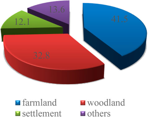
FIGURE 6. The debris flow disaster land-use type of Fujiang River upstream.
Regarding farmland in the deposit fans, the steep slope generally lies upward of the deposit fan, and the gentle slope is on the downward side close to the main river. Crops such as corn and peanuts are often planted on steep land, some seasonal vegetables are cultivated along the gentle slope, and economic crops, such as Cypress and Bamboo, are planted on the sides of the field and along both banks of the gully. Some debris flow, disaster-prone areas that possess gentle slopes close to the Fujiang River have already been used for building land. The first choice of local inhabitants is to make good use of depositional land. Currently, the villages of local resettlements are distributed widely along the Fujiang River banks.
Susceptibility evaluation results: The basic characteristics of the actual debris flow watershed could be investigated and counted easily, including disaster type, loose solid materials reserves, hydrodynamic condition, gully geomorphology, land use, debris flow events, and the preliminary susceptibility evaluation, among others. Through qualitative judgments and semi-quantitative calculations, we can use this content to obtain the discriminant result of the 42 debris flow disaster-prone areas; among these, there are two high prone susceptibility sites, 28 medium prone sites, and 12 low prone sites, which account for 5, 67, and 29%, respectively. Therefore, it can be concluded that the debris flow, disaster-prone areas in the upstream Fujiang River primarily consist of medium and low susceptibility sites. Furthermore, the high prone sites only account for 5% of the total, which illustrates that post-earthquake debris flow activity has gradually changed from high susceptibility to low susceptibility to a certain extent.
Generally, current debris flow in the upstream Fujiang River is mainly shown according to its depositional characteristics. The integrity of the deposit fan is high, and the distance from the Fujiang River to the fan apex is between 100 and 350 m. The land-use types of debris flow depositional areas in the upstream Fujiang River consist of farming, foresting, and local settlements, which shows that the frequency of debris-flow activity in this region is indirectly evolving from high to stable.
This research chose three factors related to soil, organic materials, soil erosion ratio, and soil bearing capacity of the foundation to evaluate the land use of debris flow disaster-prone areas. This evaluation method can provide a beneficial reference for land utilization in debris flow deposit-prone areas.
Many factors can affect the evaluation results, such as soil structure, soil particle distribution, soil nutrients, and soil pH (Zhang et al., 2014). Geomorphology, hydrodynamic condition, and vegetation distribution are also relevant factors to debris flow disaster-prone land. On the one hand, the soil structure and soil nutrients can reflect the development of the debris flow deposit fan. On the other hand, the rush-out materials from every debris flow event would also change the soil characteristics, especially for those solid materials that came from the upper watershed (Massimo et al., 2015; Zhang et al., 2015). Moreover, a few researchers have utilized a numerical comprehensive evaluation method to evaluate the fertility level of each plot; the contribution degree of individual fertility factors was calculated based on the correlation of soil fertility index. Evaluation methods frequently used by many researchers include the Fuzzy mathematical method, cluster analysis, and principal component analysis (Huang et al., 2010; Wu et al., 2010). Therefore, we need to systematically consider additional factors to evaluate debris flow disaster-prone land utilization in future studies.
Debris flow deposit fans are among the most precious land resources in mountainous areas, especially in west China and other mountainous countries like Japan and some European countries. Meanwhile, the fan is the depositional place for the debris flow activity, representing the highest risk area for debris flow washing and flooding in the rainy season.
Considering the economic development of local governments, making good use of debris flow fans is a key factor in the near future. However, the utilization of debris flow depositional fans comes with hazard risks. To exploit and utilize debris flow in disaster-prone land and avoid disaster loss, it is necessary to discuss the stratified modes of the exploitation and utilization of the debris flow deposit fan. Through analysis of the social economy and hazard risk extent, Tan (2000) posed a viewpoint of the evolution of debris flow, disaster-prone land usage, which can be divided into three stages: initial condition, developmental, and mature (Tan, 2000), as shown in Table 9.
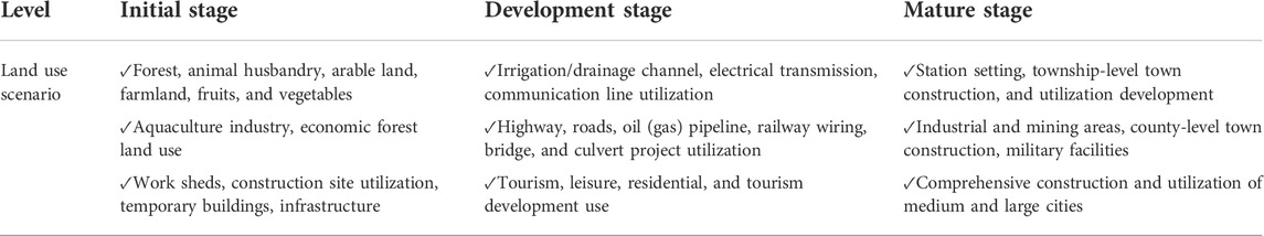
TABLE 9. Development stages for debris flow deposit fan’s usage (Tan, 2000).
Table 9 clearly shows that in the initial stage, higher risk and poorer soil properties make the debris flow deposit area most suitable for forestry, grassland, agriculture, or other temporary land uses such as for buildings or infrastructure. During the development stage, because the disaster risk is smaller and the debris flow depositional area gradually stabilizes, debris flow deposit land can be used for roads, tourism, water conservancy, and other development. In the mature period, large- and medium-sized debris flow depositional areas can be used for urban and rural construction or some other use. The tentative model of land-use scenarios for the debris flow deposit fans is given in Tan (2000). Furthermore, sustainable rural development also requires exploring and establishing appropriate criteria for evaluation and investigation.
Local village revitalization practices need to consider both environmental protection and regional security. In addition, relevant regulations should be established to strengthen the planning and management of debris flow land use development, and appropriate regulators are needed to supervise and manage debris flow disaster land use (Löschner and Nordbeck, 2020; Zhou et al., 2020). In the meantime, for lands suitable for agricultural and aquaculture development, local government and agencies should strengthen professional knowledge training and reinforce relevant knowledge by offering technical support (He et al., 2020). Regarding the debris flow disaster-prone land utilization measures, local governments first need to require evaluations of the hazard. Different catchments need to be treated accordingly upon considering variations in soil fertility and other factors. In future work, we need to systematically consider more factors to evaluate debris flow disaster-prone land utilization.
This study has taken a debris flow deposit-prone area of the upstream Fujiang River as its research target, carried out a field investigation and interviews with residents.
To characterize the debris flow disaster-prone area background of the upstream Fujiang River, we first chose the soil fertility quality, soil particle conservation, and engineering condition from other factors. Then based on the grading of these three factors, we obtained the planting type based on soil fertility/quality, land-use type based on soil conservation, and construction type based on the engineering geological characteristics. According to the grading value of each factor, we obtained the debris flow disaster-prone land-use evaluation R-value based on the hierarchy analytic process method. The evaluation formula can obtain the debris flow disaster potential land use in the low, medium, and high extent levels; the interval evaluation values are 1.00–2.00, 2.00–3.00, and 3.00–4.00, respectively.
We obtained four land-use scenarios by the Huangjiaba debris flow disaster-prone area as an example. The value of the four scenarios are calculated between 1.00 and 4.00, regarding each land-use scenario and R-value, we offer utilization advice for each land scenario. The village scenario needs to refer to the village space planning and risk assessment protocols, the agriculture scenario can be used in the high soil fertility area, the soil and water conservation scenario is affected by debris flow and floods, so fast-growing trees and shrubs can be planted along the overflow side of the ditch, and the potential construction scenario is best suited for infrastructure because of its low soil fertility, which can help in rural space planning for the local government in advance.
According to the 42 debris flow deposit fans along the Fujiang Riverbank. It show that the developmental tendencies of the debris flow disaster areas appear to deposit recently, the average distance from the gully outlet to the Fujiang River is between 100 and 350 m, which is affected by watershed and debris flow activity intensity. Further studies still need to systematically consider more factors to evaluate debris flow and disaster-prone land utilization, which can provide a reference for the rural space planning for the local government.
The original contributions presented in the study are included in the article/supplementary material, further inquiries can be directed to the corresponding author.
SY carried out the field investigation, data analysis, and manuscript writing. HP involved in manuscript supervision. TS undertook the field survey, participated in the discussion and decision-making process. JJ was involved in writing reviewing, manuscript editing, and supervision. YT undertook the field survey and discussion in advance. KC was involved in supervision. All the authors participated and contributed to the final manuscript.
This research work was supported by the Talent Introduction Program of Xihua University (Grand No. Z211016), the National Natural Science Foundation of China (Grant No. 42077275) and China Geological Survey Project (Grand No. DD20160251).
The authors declare that the research was conducted in the absence of any commercial or financial relationships that could be construed as a potential conflict of interest.
All claims expressed in this article are solely those of the authors and do not necessarily represent those of their affiliated organizations, or those of the publisher, the editors and the reviewers. Any product that may be evaluated in this article, or claim that may be made by its manufacturer, is not guaranteed or endorsed by the publisher.
Cao, S., Liu, Y., and Yu, Z. (2018). China's successes at combating desertification provide roadmap for other nations. Environ. Sci. Policy Sustain. Dev. 60 (2), 16–24. doi:10.1080/00139157.2018.1419002
Chen, T., Jiao, J., Chen, Y., Lin, H., Wang, H., and Bai, L. (2021). Distribution and land use characteristics of alluvial fans in the Lhasa River Basin, Tibet. J. Geogr. Sci. 31 (10), 1437–1452. doi:10.1007/s11442-021-1905-1
Chen, T., Peng, L., Liu, S., and Wang, Q. (2017). Land cover change in different altitudes of guizhou-guangxi karst mountain area, China: Patterns and drivers. J. Mt. Sci. 14 (9), 1873–1888. doi:10.1007/s11629-016-4202-1
Cui, P., Ge, Y., Zhuang, J., and Wang, D. (2009). Soil evolution features of debris flow waste-shoal land. J. Mt. Sci. 6, 181–188. doi:10.1007/s11629-009-1035-1
Cui, P., Hu, K., Zhuang, J., Yang, Y., and Zhang, J. (2011). Prediction of debris-flow danger area by combining hydrological and inundation simulation methods. J. Mt. Sci. 8, 1–9. doi:10.1007/s11629-011-2040-8
Cui, P., Wang, D., and Zhuang, J. (2008). Land exploitation and utilization on debris-flow fan. Sci. Soil Water Conservation 6 (1), 6–11. (in Chinese).
Gregoretti, C., Degetto, M., and Boreggio, M. (2016). GIS-based cell model for simulating debris flow runout on a fan. J. Hydrology 534, 326–340. doi:10.1016/j.jhydrol.2015.12.054
He, S., Wang, D., Chen, S., Zhang, S., and Chang, S. (2016). Natural consolidation characteristics of viscous debris flow deposition. J. Mt. Sci. 13 (10), 1723–1734. doi:10.1007/s11629-016-3850-5
He, S., Wang, D., Li, Y., Fang, Y., Lan, H., and Chen, W. (2019). Implementation of a landscape ecological use pattern model: Debris flow waste-shoal land use in the Yeyatang Basin, Yunnan Province, China. Land Use Policy 81, 483–492. doi:10.1016/j.landusepol.2018.11.024
He, S., Wang, D., Li, Y., and Zhao, P. (2018). Land use changes and their driving forces in a debris flow active area of Gansu Province, China. Sustainability 10 (8), 2759. doi:10.3390/su10082759
He, S., Wang, D., Zhao, P., Li, Y., Lan, H., Chen, W., et al. (2020). A review and prospects of debris flow waste-shoal land use in typical debris flow areas, China. Land Use Policy 99, 105064. doi:10.1016/j.landusepol.2020.105064
Hu, W., Dong, X., Xu, Q., Wang, G., Van Asch, T., and Hicher, P. (2016). Initiation processes for run-off generated debris flows in the Wenchuan earthquake area of China. Geomorphology 253, 468–477. doi:10.1016/j.geomorph.2015.10.024
Huang, T., Yue, X., Ge, X., and Wang, X. (2010). Evaluation of soil quality on gully region of loess plateau based on principal component analysis. Agric. Res. Arid Areas 28 (3), 141–147. (in Chinese).
Ibe, K., and Ebe, A. (2000). Impacts of debris-flow deposits on hydrogeochemical processes and the development of dryland salinity in the Cross-River catchment, SE, Nigeria. Environ. Monit. Assess. 64 (2), 449–456. doi:10.1023/A:1006352922219
Imaizumi, F., Sidle, R., Tsuchiya, S., and Ohsaka, O. (2006). Hydrogeomorphic processes in a steep debris flow initiation zone. Geophys. Res. Lett. 33 (10), L10404. doi:10.1029/2006GL026250
Jakob, M., and Hungr, O. (2005). “Introduction,” in Debris-flow hazards and related phenomena. Editors M. Jakob, and O. Hungr (Berlin, Heidelberg: Springer), 1–7. doi:10.1007/3-540-27129-51
Liu, H., Liu, Y., Bi, R., Xu, Y., and Wang, S. (2016). Reuse type judgment of mining wasteland based on land use competitiveness. Trans. Chin. Soc. Agric. Eng. 32 (10), 258–266. (in Chinese).
Liu, Y. (2018). Introduction to land use and rural sustainability in China. Land Use Policy 74, 1–4. doi:10.1016/j.landusepol.2018.01.032
Liu, Y., Wei, F., Li, H., and Ai, N. (2001). The influence of exploitation of debris flow waste-shoal land on environment of ravine basin-taking Jiangjia Ravine Basin in Yunan Province as an Example. J. Catastrophology 16 (2), 18–22. (in Chinese). doi:10.3969/j.issn.1000-811X.2001.02.004
Liu, Z., Qiu, H., Zhu, Y., Liu, Y., Yang, D., Ma, S., et al. (2022). Efficient identification and monitoring of landslides by time-series InSAR combining single- and multi-look phases. Remote Sens. 14, 1026. doi:10.3390/rs14041026
Löschner, L., and Nordbeck, R. (2020). Switzerland’s transition from flood defence to flood-adapted land use–A policy coordination perspective. Land Use Policy 95, 103873. doi:10.1016/j.landusepol.2019.02.032
Massimo, D., Carlo, G., and Martino, B. (2015). Comparative analysis of the differences between using Lidar and contour-based DEMs for hydrological modeling of runoff generating debris flows in the dolomites. Front. Earth Sci. 3, 21. doi:10.3389/feart.2015.00021
Okunishi, K., and Suwa, H. (2001). Assessment of debris-flow hazards of alluvial fans. Nat. Hazards (Dordr). 23 (2), 259–269. doi:10.1023/A:1011162516211
Qiu, H., Zhu, Y., Zhou, W., Sun, H., He, J., and Liu, Z. (2022). Influence of DEM resolution on landslide simulation performance based on the Scoops3D model. Geomatics, Nat. Hazards Risk 13 (1), 1663–1681. doi:10.1080/19475705.2022.2097451
Sancho, C., Peña, J. L., Rivelli, F., Rhodes, E., and Muñoz, A. (2008). Geomorphological evolution of the Tilcara alluvial fan (Jujuy Province, NW Argentina): Tectonic implications and palaeoenvironmental considerations. J. S. Am. Earth Sci. 26 (1), 68–77. doi:10.1016/j.jsames.2008.03.005
Siegert, M. (2016). Environmental sciences in the twenty-first century. Front. Environ. Sci. 4, 16. doi:10.3389/fenvs.2016.00016
Tan, W. (2000). Debris flow fan types and land-use models. Geogr. Territ. Res. 16 (1), 71–75. (in Chinese). doi:10.3969/j.issn.1672-0504.2000.01.016
Tecca, P., and Genevois, R. (2009). Field observations of the june 30, 2001 debris flow at acquabona (dolomites, Italy). Landslides 6 (1), 39–45. doi:10.1007/s10346-009-0145-8
Tiranti, D., and Deangeli, C. (2015). Modeling of debris flow depositional patterns according to the catchment and sediment source area characteristics. Front. Earth Sci. (Lausanne). 3, 8. doi:10.3389/feart.2015.00008
Wang, D., Cui, P., Zhu, B., and Wei, F. (2003). Soil fertility properties of debris flow waste-shoal land in Jiangjia Gully of Yunnan province. Bull. Soil Water Conservation 23 (6), 7–11. (in Chinese). doi:10.3969/j.issn.1000-288X.2003.06.002
Wang, J., Yang, S., Ou, G., Gong, Q., and Yuan, S. (2018). Debris flow hazard assessment by combining numerical simulation and land utilization. Bull. Eng. Geol. Environ. 77 (1), 13–27. doi:10.1007/s10064-017-1006-7
Wang, L., Qiu, H., Zhou, W., Zhu, Y., Liu, Z., Ma, S., et al. (2022). The post-failure spatiotemporal deformation of certain translational landslides may follow the pre-failure pattern. Remote Sens. 14, 2333. doi:10.3390/rs14102333
Wu, Y., Tian, X., Nan, X., Chi, W., Yan, X., and Zhu, R. (2010). Evaluation of soil quality under conservation tillage via factor and cluster analyses. Chin. J. Eco-Agriculture 18 (2), 223–228. (in Chinese). doi:10.3724/sp.j.1011.2010.00223
Xu, S., Li, C., and Wang, M. (2001). Xiaojiang debris flow and its bottomland exploitation in Yunnan, Southwest China. Earth Sci. Front. 8 (2), 296–300. (in Chinese). doi:10.3321/j.issn:1005-2321.2001.02.012
Zhang, G., Deng, H., Du, K., Lin, Y., Ma, R., and Wang, D. (2014). Comprehensive estimation of soil fertility in different land use types of debris flow waste-shoal land. J. Fujian Coll. For. 34 (3), 214–219. (in Chinese). doi:10.3969/j.issn.1001-389X.2014.03.005
Zhang, S., Wang, D., Mei, Y., Chang, S., and Wang, H. (2015). Effects of land use types on soil properties in a small watershed of debris flow activity region. J. Soil Water Conserv. 29, 258–262. (in Chinese). doi:10.13870/j.cnki.stbcxb.2015.01.049
Zhou, W., Qiu, H., Wang, L., Pei, Y., Tang, B., Ma, S., et al. (2022). Combining rainfall-induced shallow landslides and subsequent debris flows for hazard chain prediction. CATENA 213, 106199. doi:10.1016/j.catena.2022.106199
Keywords: debris flow, land use evaluation, disaster deposit area, scenario, utilization advice
Citation: Yang S, Pan H, She T, Jiao J, Tian Y and Chen K (2022) Land-use evaluation and utilization advice research on debris flow disaster deposit area. Front. Earth Sci. 10:989488. doi: 10.3389/feart.2022.989488
Received: 08 July 2022; Accepted: 22 July 2022;
Published: 17 August 2022.
Edited by:
Haijun Qiu, Northwest University, ChinaReviewed by:
Jiangcheng Huang, Yunnan University Kunming, ChinaCopyright © 2022 Yang, Pan, She, Jiao, Tian and Chen. This is an open-access article distributed under the terms of the Creative Commons Attribution License (CC BY). The use, distribution or reproduction in other forums is permitted, provided the original author(s) and the copyright owner(s) are credited and that the original publication in this journal is cited, in accordance with accepted academic practice. No use, distribution or reproduction is permitted which does not comply with these terms.
*Correspondence: Shun Yang, eWFuZ3NodW4wOUBmb3htYWlsLmNvbQ==
Disclaimer: All claims expressed in this article are solely those of the authors and do not necessarily represent those of their affiliated organizations, or those of the publisher, the editors and the reviewers. Any product that may be evaluated in this article or claim that may be made by its manufacturer is not guaranteed or endorsed by the publisher.
Research integrity at Frontiers
Learn more about the work of our research integrity team to safeguard the quality of each article we publish.