 Wei Jiang
 Zhiguo Pang1,2*
94% of researchers rate our articles as excellent or good
Learn more about the work of our research integrity team to safeguard the quality of each article we publish.
Find out more
BRIEF RESEARCH REPORT article
Front. Earth Sci., 25 August 2022
Sec. Environmental Informatics and Remote Sensing
Volume 10 - 2022 | https://doi.org/10.3389/feart.2022.988521
This article is part of the Research TopicHydrology, Water Resources, and Ecosystem Sustainable DevelopmentView all 10 articles
Knowledge regarding the soil erosion change patterns in Northeast Inner Mongolia (NIM) is essential for ecological security and sustainable development. Multisource satellite remote sensing with auxiliary data, including meteorology, land use, vegetation coverage, and digital elevation, was collected to establish a distributed soil erosion model to quantify the soil erosion intensity in Northeast Inner Mongolia. The results showed that soil erosion in Northeast Inner Mongolia, China, decreased by 100,654 km2 from 1978 to 2018. The area change rates of the mild, moderate, strong, intensive and severe soil erosion intensities were −48.91%, −41.41%, 32.63%, −91.15%, and −91.14%, respectively. The decrease in soil erosion was mainly located in the Hulunbuir and Tongliao regions. Our findings from satellite observations provide information about the soil erosion intensity and spatial distribution required for policy-making and the management of soil erosion prevention in Northeast Inner Mongolia.
Soil erosion leads to land degradation, sedimentation and ecological deterioration, which inevitably threaten ecological security and food production (Borrelli et al., 2021; Lyu et al., 2021). With the impact of climate change and human activities, soil erosion has become a widespread environmental problem (Li et al., 2013; Liu et al., 2020). Long-term series soil erosion investigations are helpful for improving our scientific understanding of the evolution pattern of soil erosion, objectively evaluating the control effects of soil and water conservation measures and promoting the sustainable development of the natural-economic-environment (Duan et al., 2012; Jiang et al., 2016; Lyu et al., 2021; Xie et al., 2022).
Currently, remote sensing technology is a unique means used to investigate long time series dynamic changes in soil erosion at the regional scale (Zhou et al., 2016; Alexakis et al., 2019; Long et al., 2019; Wang and Zhao, 2020). Various soil erosion parameters, including digital elevation models, vegetation cover and land use, can be extracted from multisource satellite imagery to calculate the soil erosion intensity using a soil erosion model (Jiang et al., 2016; Xiao et al., 2021; Lin and Zhao, 2022). (Liu et al., 2020) completed the national soil erosion survey of China in 2011 and employed a multistage, unequal probability, systematic area sampling method. Based on a geographic information system and remote sensing approach, (Jiang et al., 2016), applied the revised wind erosion equation (RWEQ) model to simulate the wind erosion intensity of Inner Mongolia between 2001 and 2010. (Zhou et al., 2016). further investigated the dynamic monitoring of soil wind erosion in Inner Mongolia, China, during 1985–2011 at a 1-km scale. Since the Landsat series satellites can be extended from 1972 to the present day, the information required for soil erosion models, such as land cover and vegetation cover, can be obtained from Landsat images (El Jazouli et al., 2019).
The soil erosion in Northeast Inner Mongolia (NIM), an important grain production base with black soil in China, was very severe in the last century and has been effectively curbed through ecological restoration by afforestation (Lyu et al., 2021). However, comprehensive exploration based on longer time series soil erosion change patterns in Northeast Inner Mongolia at a 30-m spatial resolution is still lacking. The motivation of this study was to determine the soil erosion dynamic change patterns in Northeast Inner Mongolia over the past four decades. To achieve this goal, two issues were addressed through the following actions: 1) multisource satellite imageries at five key time nodes (1978, 1985, 1995, 2005, and 2018) with the distributed model of soil erosion were employed to calculate the soil erosion intensity; 2) the dynamic patterns of soil erosion intensity were determined, and the driving factors of the changing patterns were explored. The main contribution of this paper is that it presents new knowledge regarding soil erosion change in Northeast Inner Mongolia, China.
Northeast Inner Mongolia is situated in Northeast China and includes 30 banners (counties, cities, districts) in four leagues (cities) of Hulunbuir, Hinggan League, Tongliao and Chifeng, with a total land area of 387,488 km2. The location of the study area is shown in Figure 1A, and it is one of the three largest black soil belts in the world, namely, the northeast black soil area. The study area involves the Erguna River, the Nenjiang River and the Liaohe River, which belong to the cold temperate zone and the mid-temperate zone continental climate zone, with an annual precipitation of 242.5–566.9 mm. The soil erosion type is mainly wind erosion with intermittent water erosion and freeze-thaw erosion in the north.
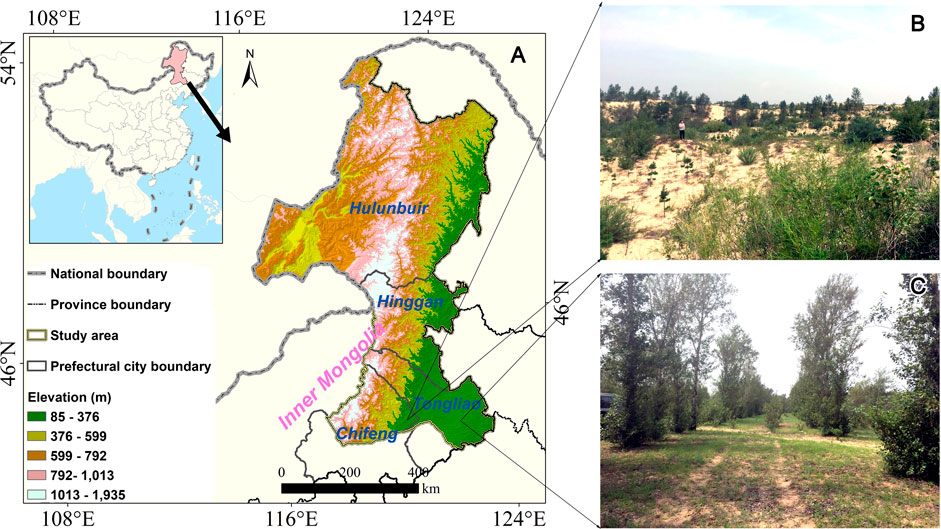
FIGURE 1. The location of the study area. (A) The boundary of Northeast Inner Mongolia. (B,C) Field survey photos after soil erosion control.
Due to the coupling of its unique climate and soil conditions with highly intensive human activities, soil erosion, especially wind erosion, has become a major threat to food security and healthy living. Over the past decades, afforestation has had an important effect on the control of soil erosion in Northeast Inner Mongolia, and vegetation cover has been successfully restored in desert (Figure 1B) and grassland areas (Figure 1C). Therefore, the use of various satellite remote sensing can better explain the evolution of soil erosion in Northeast Inner Mongolia.
According to the Regional Soil Erosion Dynamic Monitoring Technology Regulation (RSEDMTR), the technical flow of the soil erosion model was revised (Supplementary Figure S1). Considering the lack of long time series freeze–thaw observations in the study area, the soil erosion types were defined as wind erosion and water erosion. The soil erosion intensity was calculated and analyzed using the following three steps:
In the first step, to overcome the challenge of the spatial and temporal inconsistencies of multisource remote sensing and monitoring station data, the land use and land cover (LULC), vegetation coverage (VC), meteorological data and topographical data were collected from existing remote sensing products and station data, which are summarized in Supplementary Table S1. The LULC data were acquired from China’s Land-Use/Cover Datasets (CLUDs) (Liu et al., 2002; Liu et al., 2014). The CLUD dataset is a national-scale multiperiod land use/land cover thematic database constructed by manual visual interpretation using Landsat remote sensing imagery from the 1970s to 2020. The data were classified into six classes and 25 subclasses of land use with a mapping accuracy over 91%. Moderate Resolution Imaging Spectroradiometer (MODIS) normalized difference vegetation index (NDVI) products were from 2000 to 2018 with 250 m, and Global Inventory Monitoring and Modeling System (GIMMS) NDVI products are from 1981 to 2018 with 8 km. To generate the long time series vegetation coverage (VC) data, the spatiotemporal fusion algorithm was used to produce the normalized difference vegetation index (NDVI) from 1981 to 2018 with 250 m based MODIS NDVI and GIMMS NDVI (Guo et al., 2020). The slope and slope length of the terrain were obtained from digital elevation model (DEM) data with 30 m, which were acquired from the United States Geological Survey (USGS). The rainfall and wind speed of site observations acquired from the China Meteorological Administration (CMA) were converted into raster data by Kriging interpolation. The LULC, VC, meteorological data and topographical data were preprocessed at a 30 m spatial resolution.
In the second step, based on the Regional Soil Erosion Dynamic Monitoring Technology Regulation (RSEDMTR), the slope, slope length, vegetation coverage and rainfall were used to calculate the water erosion modulus by referring to the Chinese Soil Loss Equation (CSLE) (Liu et al., 2020; Liu and Liu, 2020). The land use, wind speed and vegetation coverage were employed to calculate the wind erosion modulus. According to the soil erosion classification and grading standards (Supplementary Tables S2, S3), the water and wind erosion moduli were reclassified into six intensities (slight, mild, moderate, strong, intensive and severe). The soil erosion intensity (S) for each pixel was calculated using the following formula:
where
In the third step, based on the soil erosion intensity, the spatial, temporal and intensity change patterns in Northeast Inner Mongolia from 1978 to 2018 were analyzed, and the driving factors of the change patterns were discussed.
Based on the flow of soil erosion dynamic monitoring, the results of the intensity distribution of water soil erosion and wind soil erosion in Northeast Inner Mongolia from 1978 to 2018 are shown in Figure 2. In terms of the distribution pattern of soil erosion in Northeast Inner Mongolia, the dominant soil erosion type in the study area was wind erosion, and soil erosion was located in western Hulunbuir, southern Hinggan League, Tongliao, and Chifeng. The east-central region of Hulunbuir is Greater Khingan, an important forestry base in China, with high altitudes and high forest cover. Thus, the intensity of soil erosion calculated by our method is slight in Greater Khingan. Over the past 4 decades, the wind erosion area showed a remarkable decline in the Hulunbuir and Tongliao regions, while the water erosion area remained stable. From the change area of soil erosion decline, it can be seen that wind erosion declined sharply from 2005 to 2018, which was related to afforestation ecological restoration. The intensity of soil erosion in Northeast Inner Mongolia has changed significantly over the past 40 years. The remarkable intensity change in soil erosion over the past four decades occurred in the shift from mild soil erosion to slight erosion; the area of high-intensity soil erosion has decreased significantly, especially in the farmland areas of Chifeng and Tongliao, which suggests that windbreak forests constructed around farmland effectively curb the migration of farmland soil due to wind erosion.
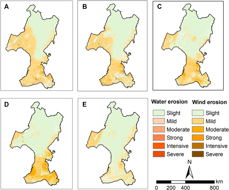
FIGURE 2. Soil erosion spatial pattern dynamic change in Northeast Inner Mongolia. (A) 1978, (B) 1985, (C) 1995, (D) 2005, (E) 2018.
The area changes in soil erosion in Northeast Inner Mongolia from 1978 to 2018 are shown in Figure 3. The soil erosion in Northeast Inner Mongolia has decreased remarkably over the past four decades. In 1978, the area of soil erosion was 203,538 km2, while in 2018, the area of soil erosion was 102,884 km2, a decrease of 100,654 km2 over the four decades. In the process of decreasing the soil erosion area, the wind erosion area decreased most significantly, with an area of 100,517 km2.
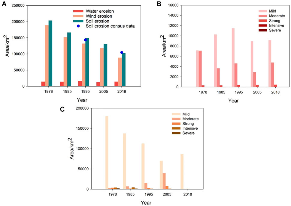
FIGURE 3. (A) Soil erosion area and validation in Northeast Inner Mongolia from 1978 to 2018. The area change of water erosion (B) and wind erosion (C) in Northeast Inner Mongolia from 1978 to 2018.
According to the Inner Mongolia soil erosion census, the areas of soil erosion in 1995 and 2018 were 143,620 km2 and 104,564 km2, respectively. Compared with the area calculated in this study, the relative errors were −3.52 and 1.63%, respectively, which indicates that the results calculated by this method are more credible.
Based on the soil erosion classification and grading standards, the mild, moderate, strong, intensive and severe intensities were categorized as soil erosion. The intensity area and change in soil erosion in different periods are summarized in Supplementary Table S3. From 1978 to 2018, mild soil erosion accounted for the largest proportion in each period, and the change rate of mild soil erosion was −48.91%. Moreover, the area of intensive and severe soil erosion decreased by more than 91%, followed by the area of mild and moderate soil erosion, while the area of strong soil erosion increased by 268 km2. The results showed that the rate of decrease of high-intensity soil erosion was sharp, and the decrease in the area of low-intensity soil erosion was large, which suggested that the high-intensity soil erosion had been converted to low-intensity soil erosion. Thus, soil and water conservation measures, such as restoring vegetation, controlling slope (channel) erosion and preventing grassland degradation, have performed well over the past four decades.
Furthermore, the area changes in water erosion intensity and wind erosion intensity over the past four decades are shown in Figure 4 Mild and moderate erosion were the main types of water erosion, with the area of mild erosion increasing by 28.47% and the area of moderate erosion decreasing by 32.57%. Regarding wind erosion, mild erosion accounted for the most intensity, and the area of decreasing mild erosion was 93,704 km2. Moreover, the areas of moderate, intensive and severe wind erosion decreased by 68.07, 91.73 and 91.22%, respectively. Thus, the decline in low-intensity wind erosion contributed to regional soil erosion improvement.
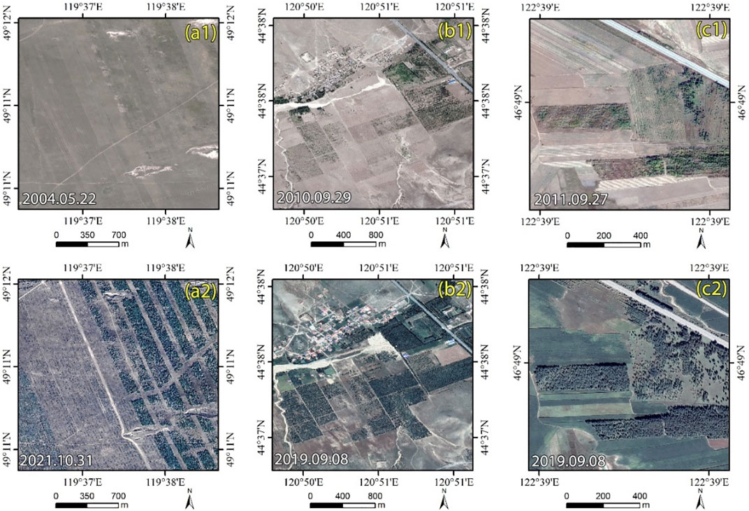
FIGURE 4. Comparison of vegetation cover by implementing afforestation measures (a1 and a2 are farmland, b1, b2, c1, and c2 are forest).
Long time series of soil erosion survey data are important for the assessment of the effectiveness of soil erosion management (Liu et al., 2020). Although long time series and high-resolution remote sensing data provide new opportunities to conduct soil erosion assessments, there are also some challenges, such as remote sensing data consistency and seasonal differences, which can lead to uncertainty in soil erosion assessments at the regional scale. Compared with previous studies (Wang et al., 2018; Zhang et al., 2018), this study collected various satellite remote sensing data and products and adopted data processing methods, such as vegetation coverage data generated using a spatiotemporal fusion algorithm, LULC data with a consistent classification system, and the soil erosion calculations referring to the Regional Soil Erosion Dynamic Monitoring Technology Regulation (RSEDMTR), to reduce the uncertainty of the data on the results. Compared to the Inner Mongolia soil erosion census, the relative error in the area of soil erosion calculated was −3.52 and 1.63% in 1995 and 2018, respectively, which indicates that the results of the soil erosion calculations are scientifically reliable. Moreover, recent studies have shown that wind erosion in Inner Mongolia has declined significantly, which is generally consistent with the findings of this study (Zhang et al., 2018).
Land use, meteorological factors, and vegetation cover are the key drivers of soil erosion pattern change (Zhu et al., 2021). In the past four decades, the slower wind speeds (Fang et al., 2022) and increased vegetation cover (Zhang et al., 2018) have collectively led to a decrease in wind erosion area. Although agricultural development may pose a risk of soil erosion, the intensity of soil erosion can be effectively reduced by planting trees around agricultural land, as shown in Figure 4 (a2). Moreover, the afforestation measures implemented in China have had a significant effect on increasing the vegetation cover in the desert area (Li et al., 2018; Wang et al., 2020). The comparison of vegetation cover is shown in Figure 4 (b1), (b2), (c1), and (c2), indicating that vegetation cover change is the main driving factor for the decline in soil erosion intensity (Yin et al., 2018).
Long-term series soil erosion investigations with remote sensing data are helpful for improving our scientific understanding of soil and water conservation management effectiveness assessments and planning. This study introduced multisource remote sensing technology and station data to explore the soil erosion change patterns in Northeast Inner Mongolia from 1978 to 2018. The results showed that the dominant soil erosion type was wind erosion, and the area of soil erosion decreased by 100,654 km2. The wind erosion area showed a remarkable decline in the Hulunbuir and Tongliao regions, while the water erosion area remained stable. The remarkable intensity change in soil erosion over the past four decades occurred in the shift from mild soil erosion to slight erosion; the area of high-intensity soil erosion has decreased significantly. The area change rates of the mild, moderate, strong, intensive and severe soil erosion intensities were −48.91%, −41.41%, 32.63%, −91.15%, and −91.14%, respectively. The slower wind speeds and increased vegetation cover have collectively led to a decrease in wind erosion area, and the vegetation cover change derived by afforestation measures is the main driving factor for the decline in soil erosion intensity. The present study objectively reveals the changes in soil erosion in Northeast Inner Mongolia under the joint action of human activity and the natural environment and can provide support for safeguarding food security and ecologically sustainable development.
The original contributions presented in the study are included in the article/Supplementary Material, further inquiries can be directed to the corresponding authors.
WJ conceived and designed the framework, performed the experiments, and wrote the paper. ZP and JL contributed to data preparation and analysis. HJ, LL, and JF performed the experiments. All authors discussed the results and contributed to the final manuscript.
This research was funded by the Water Conservancy Technology Demonstration Project (SF-202001), and Innovation Talent Project of the Research Center of Flood and Drought Disaster Reduction of the Ministry of Water Resources (202110) and National Natural Science Foundation of China (51779269).
We give thanks to the research team at the China’s Land-Use/Cover Datasets (CLUDs), United States Geological Survey and China Meteorological Administration for providing the multisource data. The authors thank editors and three reviewers for their valuable comments to improve our manuscript.
The authors declare that the research was conducted in the absence of any commercial or financial relationships that could be construed as a potential conflict of interest.
All claims expressed in this article are solely those of the authors and do not necessarily represent those of their affiliated organizations, or those of the publisher, the editors and the reviewers. Any product that may be evaluated in this article, or claim that may be made by its manufacturer, is not guaranteed or endorsed by the publisher.
The Supplementary Material for this article can be found online at: https://www.frontiersin.org/articles/10.3389/feart.2022.988521/full#supplementary-material
Alexakis, D. D., Tapoglou, E., Vozinaki, A.-E. K., and Tsanis, I. K. (2019). Integrated use of satellite remote sensing, artificial neural networks, field spectroscopy, and GIS in estimating crucial soil parameters in terms of soil erosion. Remote Sens. 11 (9), 1106. doi:10.3390/rs11091106
Borrelli, P., Alewell, C., Alvarez, P., Anache, J. A. A., Baartman, J., Ballabio, C., et al. (2021). Soil erosion modelling: A global review and statistical analysis. Sci. total Environ. 780, 146494. doi:10.1016/j.scitotenv.2021.146494
Duan, X., Xie, Y., Liu, B., Liu, G., Feng, Y., and Gao, X. (2012). Soil loss tolerance in the black soil region of Northeast China. J. Geogr. Sci. 22 (4), 737–751. doi:10.1007/s11442-012-0959-5
Fang, K., Bai, M., Azorin-Molina, C., Dong, Z., Camarero, J. J., Zhang, P., et al. (2022). Wind speed reconstruction from a tree-ring difference index in northeastern Inner Mongolia. Dendrochronologia 72, 125938. doi:10.1016/j.dendro.2022.125938
Guo, Y., Wang, C., Lei, S., Yang, J., and Zhao, Y. (2020). A framework of spatio-temporal fusion algorithm selection for Landsat NDVI time series construction. ISPRS Int. J. Geo-Information 9 (11), 665. doi:10.3390/ijgi9110665
Jazouli, A., Barakat, A., Khellouk, R., Rais, J., and Baghdadi, M. (2019). Remote sensing and GIS techniques for prediction of land use land cover change effects on soil erosion in the high basin of the Oum Er Rbia River (Morocco). Remote Sens. Appl. Soc. Environ. 13, 361–374. doi:10.1016/j.rsase.2018.12.004
Jiang, L., Xiao, Y., Zheng, H., and Ouyang, Z. (2016). Spatio-temporal variation of wind erosion in Inner Mongolia of China between 2001 and 2010. Chin. Geogr. Sci. 26 (2), 155–164. doi:10.1007/s11769-016-0797-y
Li, D., Xu, D., Wang, Z., You, X., Zhang, X., and Song, A. (2018). The dynamics of sand-stabilization services in Inner Mongolia, China from 1981 to 2010 and its relationship with climate change and human activities. Ecol. Indic. 88, 351–360. doi:10.1016/j.ecolind.2018.01.018
Li, X., Wu, B., and Zhang, L. (2013). Dynamic monitoring of soil erosion for upper stream of Miyun Reservoir in the last 30 years. J. Mt. Sci. 10 (5), 801–811. doi:10.1007/s11629-013-2559-y
Lin, H., and Zhao, Y. (2022). Soil erosion assessment of alpine grassland in the source park of the yellow river on the qinghai-Tibetan plateau, China. Front. Ecol. Evol. 9, 771439. doi:10.3389/fevo.2021.771439
Liu, J., Liu, M., Deng, X., Zhang, Z., and Luo, D. (2002). The land use and land cover change database and its relative studies in China. J. Geogr. Sci. 12 (3), 275–282. doi:10.1007/s11769-002-0033-9
Liu, J., Kuang, W., Zhang, Z., Xu, X., Qin, Y., Ning, J., et al. (2014). Spatiotemporal characteristics, patterns, and causes of land-use changes in China since the late 1980s. J. Geogr. Sci. 24 (2), 195–210. doi:10.1007/s11442-014-1082-6
Liu, B., Xie, Y., Li, Z., Liang, Y., Zhang, W., Fu, S., et al. (2020). The assessment of soil loss by water erosion in China. Int. Soil Water Conservation Res. 8 (4), 430–439. doi:10.1016/j.iswcr.2020.07.002
Liu, J., and Liu, H. (2020). Soil erosion changes during the last 30 years and contributions of gully erosion to sediment yield in a small catchment, southern China. Geomorphology 368, 107357. doi:10.1016/j.geomorph.2020.107357
Long, T., Zhang, Z., He, G., Jiao, W., Tang, C., Wu, B., et al. (2019). 30 m resolution global annual burned area mapping based on Landsat images and google earth engine. Remote Sens. 11 (5), 489. doi:10.3390/rs11050489
Lyu, X., Li, X., Wang, H., Gong, J., Li, S., Dou, H., et al. (2021). Soil wind erosion evaluation and sustainable management of typical steppe in Inner Mongolia, China. J. Environ. Manag. 277, 111488. doi:10.1016/j.jenvman.2020.111488
Wang, H., and Zhao, H. (2020). Dynamic changes of soil erosion in the taohe river basin using the RUSLE model and Google Earth engine. Water 12 (5), 1293. doi:10.3390/w12051293
Wang, L.-Y., Xiao, Y., Rao, E.-M., Jiang, L., Xiao, Y., and Ouyang, Z.-Y. (2018). An assessment of the impact of urbanization on soil erosion in Inner Mongolia. Int. J. Environ. Res. public health 15 (3), 550. doi:10.3390/ijerph15030550
Wang, Z., Peng, D., Xu, D., Zhang, X., and Zhang, Y. (2020). Assessing the water footprint of afforestation in Inner Mongolia, China. J. Arid Environ. 182, 104257. doi:10.1016/j.jaridenv.2020.104257
Xiao, Y., Yang, B., Guo, Y., Lu, R., Zhang, D., Zhang, D., et al. (2021). Spatial-temporal evolution patterns of soil erosion in the yellow river basin from 1990 to 2015: Impacts of natural factors and land use change. Geomatics, Nat. Hazards Risk 12 (1), 103–122. doi:10.1080/19475705.2020.1861112
Xie, Y., Wang, L., An, R., Luo, X., Lu, Y., Liu, Y., et al. (2022). The effect of sloping land conversion program on soil erosion in shaanxi province, China: A spatial panel approach. Front. Environ. Sci. 10, 913712. doi:10.3389/fenvs.2022.913712
Yin, H., Pflugmacher, D., Li, A., Li, Z., and Hostert, P. (2018). Land use and land cover change in Inner Mongolia - understanding the effects of China's re-vegetation programs. Remote Sens. Environ. 204, 918–930. doi:10.1016/j.rse.2017.08.030
Zhang, H., Fan, J., Cao, W., Harris, W., Li, Y., Chi, W., et al. (2018). Response of wind erosion dynamics to climate change and human activity in Inner Mongolia, China during 1990 to 2015. Sci. Total Environ. 639, 1038–1050. doi:10.1016/j.scitotenv.2018.05.082
Zhou, Y., Guo, B., Wang, S., Tao, H., Liu, W., Yang, G., et al. (2016). Dynamic monitoring of soil wind erosion in Inner Mongolia of China during 1985-2011 based on geographic information system and remote sensing. Nat. Hazards 83 (1), 1–17. doi:10.1007/s11069-015-1763-1
Keywords: soil erosion, long time series, remote sensing, change pattern, northeast inner Mongolia
Citation: Jiang W, Pang Z, Lv J, Ju H, Li L and Fu J (2022) Satellite observations reveal decreasing soil erosion in Northeast Inner Mongolia, China, over the past four decades. Front. Earth Sci. 10:988521. doi: 10.3389/feart.2022.988521
Received: 07 July 2022; Accepted: 29 July 2022;
Published: 25 August 2022.
Edited by:
Wenlong Jing, Guangzhou Institute of Geography, ChinaReviewed by:
Min Zhao, Beijing Normal University, ChinaCopyright © 2022 Jiang, Pang, Lv, Ju, Li and Fu. This is an open-access article distributed under the terms of the Creative Commons Attribution License (CC BY). The use, distribution or reproduction in other forums is permitted, provided the original author(s) and the copyright owner(s) are credited and that the original publication in this journal is cited, in accordance with accepted academic practice. No use, distribution or reproduction is permitted which does not comply with these terms.
*Correspondence: Wei Jiang, amlhbmd3ZWlAaXdoci5jb20=; Zhiguo Pang, cGFuZ3pnQGl3aHIuY29t
Disclaimer: All claims expressed in this article are solely those of the authors and do not necessarily represent those of their affiliated organizations, or those of the publisher, the editors and the reviewers. Any product that may be evaluated in this article or claim that may be made by its manufacturer is not guaranteed or endorsed by the publisher.
Research integrity at Frontiers
Learn more about the work of our research integrity team to safeguard the quality of each article we publish.