 Hexin Bao
 Shanghong Zhang
 Caihong Tang
- School of Water Resources and Hydropower Engineering, North China Electric Power University, Beijing, China
The construction of water conservancy projects not only brings benefits such as flood control and disaster reduction but also has many effects on the habitat and reproduction of local aquatic organisms. Taking the reach from Xuzhuang Station to Gaocun Station in the lower Yellow River as an example, this paper discusses the effect of the Xiaolangdi Reservoir on the habitat of Yellow River carp (Cyprinus carpio). By constructing a two-dimensional hydrodynamic model, coupled with a habitat suitability model of the spawning ground of Yellow River carp, the weighted usable area (WUA) of the Yellow River carp habitat was calculated, and the spatial distribution of the habitat suitability index (HSI) in the reach was analyzed to evaluate habitat quality before and after the construction of the Xiaolangdi Reservoir. The results showed that the Xiaolangdi Reservoir had a negative effect on the habitat of Yellow River carp, resulting in the reduction of the spatial distribution of HSI, a decrease in WUA by 45.53%, and a decrease in habitat quality. The construction of the Xiaolangdi Reservoir reduced or even eliminated flow pulses in the downstream reach, but had little effect on the suitability index of water depth and velocity. However, the suitability index of water level rise was significantly reduced, which is not conducive to the spawning activities of aquatic organisms and has a negative effect on habitat. The results of this study will provide a reference for ecological restoration in this region.
1 Introduction
Dams are one of the most common types of water conservancy projects that involve the anthropogenic transformation of rivers. Dam construction not only changes a region’s hydrology but also has ecosystem effects that cannot be ignored. Studies have shown that in the past century, dam construction was the main contributor to the endangered status of 20% of threatened freshwater fish globally (Chen et al., 2009). Dam construction changes the connectivity of rivers, affecting or even removing fish migration channels; has negative effects on fish behavior; alters the structure of fish communities and reduces biodiversity (Tiemann et al., 2004). As a result, reservoir water depth increases and the flow rate slows down, which can easily cause floating fish eggs to sink to the bottom of the reservoir where they are unable to hatch normally, posing a threat to fish reproduction (Marchamalo et al., 2007). Accurate assessment of the ecological effects of dam construction is of great importance to the protection and management of the environment.
As the top community in aquatic ecosystems, fish affect the existence and abundance of other groups (Xu et al., 2005). Changes in fish community structure are directly related to the overall change of aquatic communities and aquatic habitats (Chen et al., 2007). The Yellow River carp (Cyprinus carpio) is the most important fish resource in the Yellow River. It has large biomass and strong environmental adaptability, which is beneficial to the accurate and timely assessment of habitat changes in the river, and it is the key species in the lower reaches of the Yellow River (Jiang et al., 2005). However, because of the effects of dam construction and other human activities, the average annual resource loss of fish in the Yellow River is large, and the weight of catches is also reduced by water-sediment regulation (Zhu et al., 2012).
The stress effect of dam construction on fish habitats has always been a contentious issue, generating a high level of debate. On the one hand, dam construction changes river hydrology, resulting in the alteration of fish spawning grounds and catch decline. In the Guaporé River Basin, damming reduced catch from 163.8 tons per year to 10.8 tons per year (Sousa et al., 2021), and fisheries development is constrained. In China, because of the successive completion of Gezhouba Dam and the Three Gorges Dam, the total spawning output of the four major fish species at Jianli Station during the 4 years from 2003 to 2006 was 42.82% of the average value from 1997 to 2002 before the impoundment, and the scale of spawning was significantly reduced (Duan et al., 2008). The number of endangered Chinese sturgeon (Acipenser sinensis) decreased sharply, and their spawning ground decreased from 800 km reach before the dam construction to only 30 km reach near the lower Gezhouba Dam after construction (Ban et al., 2011). On the other hand, the environmental differences and the loss of connectivity caused by the completion of the dam greatly affect the composition of fish communities. Fishes that rely on the connectivity of rivers to complete reproductive activities are most affected by dam construction (Hoeinghaus et al., 2009). In contrast, the number of small, slow-flow, highly fecund fish that eat a diverse range of foods increases (Tundisi, 2018). Field survey results have shown that after the completion of the Longtan Reservoir, the resources of larger species such as Semilabeo notabilis and Tor brevifilis brevifilis are significantly reduced, and the species with fewer original sources such as Spinibarbus denticulatus denticulatus and Cyprinus multitaeniata are at risk of leaving the distribution area (Wang et al., 2014). In addition, the physical obstacles formed by the construction of dams not only block fish migration channels and the transportation and circulation of nutrients (Linhoss et al., 2012), but also have a negative effect on water quality by changing the flow, sediment, and temperature of water from that of natural conditions (Macklin et al., 2003; Bouaroudj et al., 2019; Luo et al., 2021).
Among the many changes brought about by dam construction, alterations in hydrological conditions affect fish reproduction especially (Cao et al., 2022). To improve the current state of river habitats and provide suitable habitat for aquatic organisms, much research has been carried out by domestic and international scholars on the response of fish to the changes in hydrological conditions caused by dam construction. Studies have shown that in addition to flow velocity, water depth, sediment, and other factors, flow pulses can conduct biological signals to fish, thereby stimulating biological development, migration, reproduction, and other activities (Poff et al., 1997; Bunn and Arthington, 2002). Li et al. (2012) analyzed the changes in regional hydrological indicators after dam construction and pointed out that the change in regional flow tends to be moderate, which weakens or even eliminates the spawning signals of the four major Chinese fish species (namely, black carp (Mylopharyngodon piceus), grass carp (Ctenopharyngodon idella), silver carp (Hypophthalmichthys molitrix), and bighead carp (Aristichthys nobilis)), and it is difficult to achieve the best conditions for spawning and reproduction of these species. With the improvement of simulation accuracy of hydrodynamic numerical models, Jiang et al. (2010) combined a two-dimensional hydrodynamic model with a habitat model, and the results indicated that runoff components are closely related to the ecological habits of fish. The decrease or even disappearance of the flow pulse components after the dam construction affects fish spawning. Li and Xia (2011) calculated the suitable ecological flow during the spawning period by coupling a three-dimensional hydraulic model and a habitat model. Andreia Dos Santos et al. (2022) conducted statistical analysis on the short-sequence data obtained before and after dam construction and confirmed that it caused significant changes in fish richness, biomass, and species composition with the help of a species cumulative curve and a linear mixed model. Li et al. (2006), and Wang and Yin (2019) used the IHA (Indicators of Hydrologic Alteration) hydrological index change method (Richter et al., 1996) to analyze the correlation between the change in fish spawning output and the change in river hydrological conditions in a long time series, and pointed out that the weakening of the flow pulse index led to the change of fish spawning peak and a decrease in the scale of spawning.
Although many scholars have studied the effect of flow pulses on fish spawning activities, most of them focus on hydrological indicators and fixed flow calculation, which cannot accurately quantify the effect of flow pulses on fish spawning activities. Among many hydrological factors, the continuous spatiotemporal changes of flow velocity, water depth and water level rise can better reflect the effect of a single flow pulse on regional rivers and aquatic organisms. In this study, a habitat suitability model for Yellow River carp was established by pairing a two-dimensional hydrodynamic model with a method of equidistant subdivision of unsteady flood process and gradual calculation. The effects of three habitat factors, namely water depth, flow velocity and water level rise, on the spawning activity of Yellow River carp before and after the construction of Xiaolangdi Reservoir, were analyzed, as was the habitat quality of Yellow River carp in the region.
2 Study area and species
2.1 Study area
The lower reaches of the Yellow River are the most unstable section of the Yellow River Basin, with the most pronounced contrast between flood disasters and water supply and demand. The river regime of this section is changeable and the mainstream moves frequently. The special conditions of this section provide habitats for fish and rare birds. The Zhengzhou section of the Yellow River is the national aquatic germplasm resource reserve of Yellow River carp and is one of the main spawning sites of Yellow River carp (Hui et al., 2019). Affected by the operation of the Xiaolangdi Reservoir, the annual maximum flow and maximum water level in the downstream reach of Xiaolangdi Reservoir have been greatly reduced, and the seasonal water area of wetlands in the adjacent area of the Zhengzhou section has been reduced (Zhang et al., 2010) and the fish habitat area is shrinking. In this study, Xuzhuang Station in the Zhengzhou section of the Yellow River was selected as the upstream boundary, Gaocun Station, approximately 145 km downstream, was selected as the downstream boundary and the river section between the two stations was selected as the study area (Figure 1).
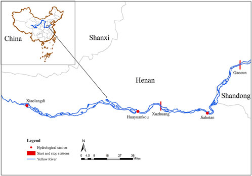
FIGURE 1. Location of the study area on the Yellow River, China.
2.2 Species
The Yellow River carp, Cyprinus carpio, is a unique aquatic organism in the lower reaches of the Yellow River. It often lives in the soft river bottom in areas with slow flow rates, or in shallow water areas where waterweeds are clustered. It produces sticky eggs which adhere to waterweeds and other attachments. The spawning time is from April to June each year, and its different life stages have different habitat needs (Jiang et al., 2009) (Table 1). Since the 1950s, the ecological balance of the lower Yellow River has been seriously damaged by human activities, and the resources of Yellow River carp have declined sharply.
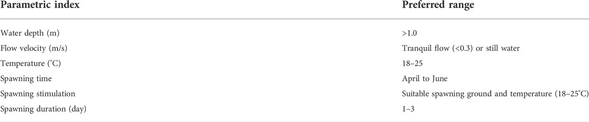
TABLE 1. Requirements for spawning habitat of Yellow River carp.
3 Methods
3.1 Two-dimensional hydrodynamic model
Compared with one-dimensional hydrodynamic models, two-dimensional hydrodynamic models can not only present the two-dimensional spatial distribution of hydrological factors such as velocity, water depth, and water level but also simulate the local flow pattern of the river more accurately, which can provide a more accurate measure of habitat suitability and weighted available area.
MIKE21 is a two-dimensional mathematical model developed by the Danish Institute of Hydraulics to simulate the flow, waves, sediment, and environment of rivers, lakes, estuaries, bays, coasts, and oceans. The basic data needed to build a MIKE21 hydrodynamic model includes terrain elevation data, hydrological data, roughness, and other specific data such as waves, winds, and tidal levels. An unstructured triangular mesh is used to divide the computational domain. When meshing, encryption technology is used for the narrow and curved parts of the river. The maximum grid space step size of the narrow and curved parts of the river is 50 m, 185 m for the upstream and downstream boundaries and the key river sections, and 185–6,000 m for the land areas on both sides of the river with little water. The final number of generated grids was 133,539, grid division and local details are shown in Figure 2. The elevation information of the study area was obtained from a total of 67 measured sections in 2018. The daily flow data of Xuzhuang Station are used as inflow conditions, and the daily water level data of Gaocun Station are used as export boundary conditions. The initial water level was set to 60 m, and the maximum time step was set to 1 s.
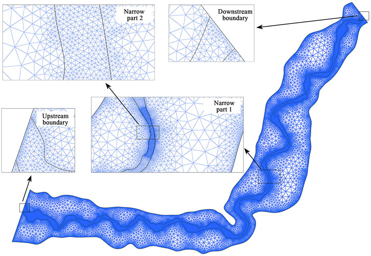
FIGURE 2. Computational grid division of the two-dimensional hydrodynamic model used in this study.
3.2 Habitat suitability model
Habitat suitability models are widely used to assess habitat quality and ability to support the survival of specific species (Vincenzi et al., 2006; Fukuda, 2009). Its basic principle is to establish a suitability index (SI) according to the requirements of ecological habits of indicator species for hydrological elements (flow velocity, water depth, sediment, and cover, etc.) and defines 0 as the habitat condition of completely unsuitable indicator species and 1 as the habitat condition of the most suitable indicator species to draw the suitability curves of different hydrological elements. The basic assumption of SI is that species tend to choose the place that can best meet their survival needs. The higher the value of SI is, the higher the frequency of occurrence of this species. To more intuitively reflect the Yellow River carp’s habitat characteristics, values from 0.5–1 were classified as “good”, 0.3–0.5 were classified as ‘moderate’, and 0–0.3 were classified as “poor” (Collier et al., 2022). Taking into consideration the availability of data, three habitat factors—water depth, velocity, and water level rise, which have a great influence on the spawning activity of Yellow River carp—were selected to construct a habitat suitability model (Wang et al., 2016; Wang et al., 2020), combined with existing research, selecting the suitability curve of each habitat factor as shown in Figure 3. Regarding the influence of multiple habitat factors on the habitat suitability of indicator species, it is necessary to combine the suitability index of single factors into the habitat suitability index (HSI), which can be calculated by the arithmetic average method:
where
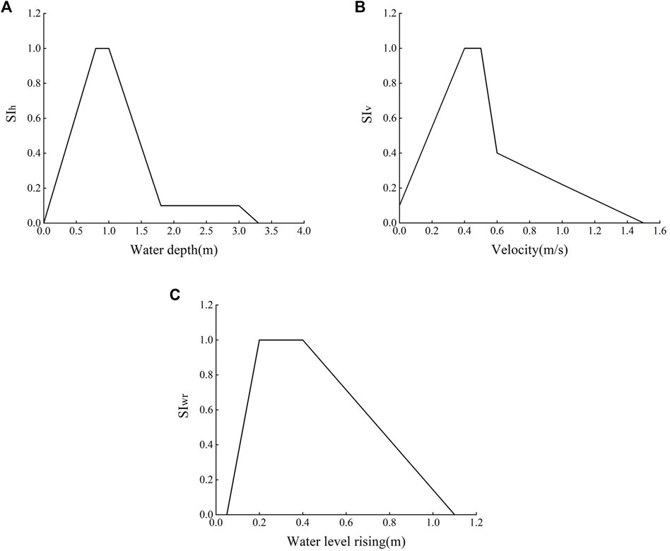
FIGURE 3. Suitability curves of different habitat factors in the habitat suitability model used in this study: water depth suitability curve (A), velocity suitability curve (B), and water level rising suitability curve (C).
By calculating the weighted usable area (WUA), we can establish a correlation between the river runoff conditions and the habitat area of Yellow River carp in a certain period in the study area, and quantitatively analyze the suitable habitat area of Yellow River carp in an inflow process. WUA can be calculated by the following formula:
where
The integrated use of the habitat suitability model and HSI and WUA parameters can be used to quantitatively evaluate the habitat quality of indicator species in the region (Yi et al., 2019; Yang et al., 2021; Collier et al., 2022). HSI indicates the degree of preference of the indicator species to the habitat. The larger the HSI value is, the more likely the indicator species are to live in that habitat. The larger the WUA value is, the larger the effective habitat area suitable for indicator species is, and the more conducive it is to indicator species reproduction.
Flow pulses can conduct biological signals that stimulate fish spawning, but it still takes some time to start spawning after the river rises. Based on this study and the research results of Wang et al. (2008), a water increase for three or more consecutive days is defined as the process that meets the requirements of spawning of Yellow River carp. To quantify the effect of a single flow pulse on the spawning activity of Yellow River carp, the spatial and temporal distribution of hydrological factors in the flood process that meets the spawning requirements of Yellow River carp were derived daily and equidistantly, based on the method of equidistant divergence, to analyze the changes of habitat factors in each stage of a single flow pulse. Combined with the suitability curves of each habitat factor, the habitat suitability of each stage in a single flow pulse was calculated, and the mean value was obtained to characterize the habitat suitability of the whole flow pulse.
The spatial distribution of water depth, velocity, and water level rise was calculated via the two-dimensional hydrodynamic model. According to the established habitat suitability model of Yellow River carp, the spatial distribution of HSI in the study area was calculated, and then the change of habitat quality before and after the dam construction at Xiaolangdi Reservoir was evaluated.
4 Results
4.1 Calibration and verification of the two-dimensional hydrodynamic model
The construction of the MIKE21 hydrodynamic model included terrain elevation data import, computational grid division, setting boundary conditions, and setting simulation parameters. Taking the reach from Xuzhuang Station to Gaocun Station in the lower Yellow River as the study area, the length of the regional river channel is approximately 145 km, from which a total of 67 measured section terrain elevation data were used to establish a two-dimensional hydrodynamic model. The hydrological data from August 16 to 14 September 2018, were used to calibrate the parameters of the model, and the bottom bed friction (the reciprocal of the Manning coefficient) in the model was adjusted to minimize the error between the simulated and measured values. After the parameter calibration was completed, the hydrological data from April 1 to June 30 in the same year were used for model verification. Model parameter settings are shown in Table 2, and water level verification results are shown in Figure 4. The verification results showed that the maximum absolute error between the simulated water level and the measured water level was 0.28 m, the maximum relative error was 0.39%, the root means square error
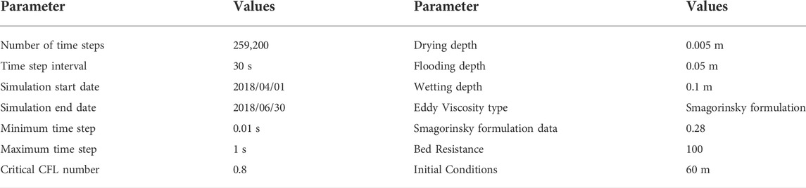
TABLE 2. Parameter setting of the MIKE21 two-dimensional hydrodynamic model.
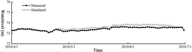
FIGURE 4. Verification results of the MIKE21 two-dimensional hydrodynamic model.
4.2 Validation of the habitat suitability model for Yellow River carp
Referring to the field survey data of previous studies on the spawning ground of Yellow River carp (Hui et al., 2019), the simulation period from May 9 to 30 June 2015, was selected to verify the accuracy of the habitat suitability model of Yellow River carp. Based on the spatial and temporal distribution of water depth, flow velocity, and water level calculated using MIKE21, combined with the suitability curve of flow velocity, water depth, and water level rise, the flow velocity suitability index
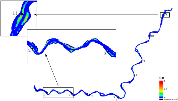
FIGURE 5. Validation of habitat suitability model for Yellow River carp.
4.3 Effect of the Xiaolangdi reservoir on the spawning ground of Yellow river carp
4.3.1 Selection of typical years
The Sanmenxia Hydropower Station is located in the upper reaches of the Xiaolangdi Reservoir. The historical hydrological data of Sanmenxia Station were analyzed using the frequency analysis method. The variation coefficient
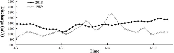
FIGURE 6. Xuzhuang Station represents the annual flow process during the pre- and post-dam period at the Xiaolangdi Reservoir on the Yellow River, China.
4.3.2 Habitat suitability simulation of typical years before and after dam construction
The MIKE21 two-dimensional hydrodynamic model can calculate the continuous spatial and temporal distribution of hydrological factors such as velocity, water depth, and water level. Taking the adjacent time step results file as the difference, the changes of other hydrological factors such as water level rise can be obtained. The proportion of numerical grids of different habitat factors before and after dam construction was counted (Table 3). The results show that the water depth in the range of 0–0.5 m and the flow velocity in the range of 1.2–1.4 m/s had the largest changes after dam construction, and were reduced by 1.98 and 0.41%, respectively. The water level rise in the range of 0–0.1 m increased by 23.64%, and the water level rise in the range of 0.1–0.2 m decreased by 16.94%.
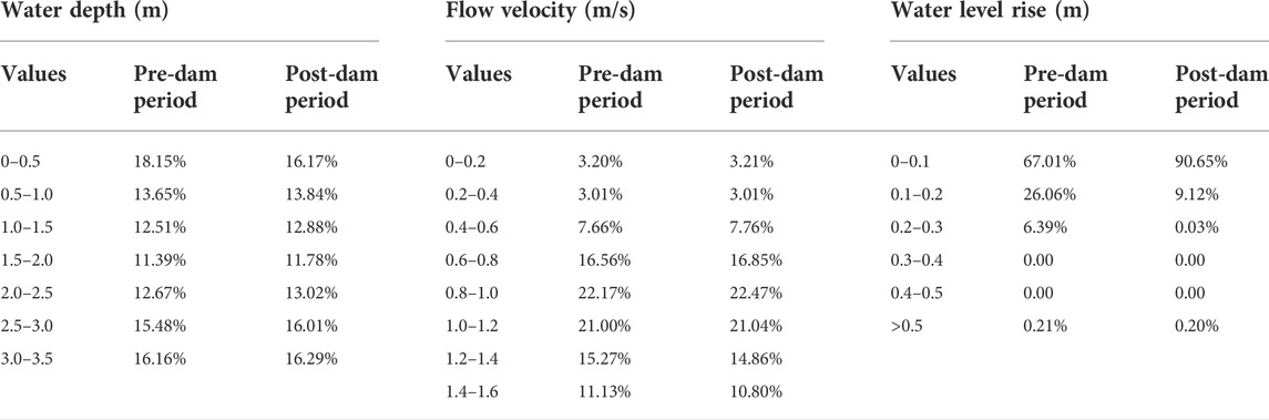
TABLE 3. Comparison of the proportions of numerical grids of habitat factors during the pre- and post-dam periods at the Xiaolangdi Reservoir on the Yellow River, China.
Continuous water level rise is a necessary condition for the normal spawning of fish. The continuous water rise durations meeting the requirements of the spawning activities of Yellow River carp for the selected representative years in the study area (Table 4) were counted. The continuous water rise duration after the dam construction was significantly reduced from 16 to 9 days. The suitable spawning time of the Yellow River carp was reduced, and the spawning activities were affected.
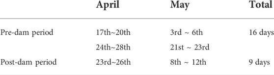
TABLE 4. Comparison of continuous water rise duration before and after dam construction at the Xiaolangdi Reservoir on the Yellow River, China.
The HSI was calculated and the spatial numerical distribution map of the river was drawn by using the arithmetic average method, taking into consideration the influence of three habitat factors: water depth, velocity, and water level rise (Figure 7). The results showed that after the construction of the Xiaolangdi Reservoir, the HSI value of the Yellow River carp decreased significantly, and the number of grids decreased by 95.3%. The total habitat division of Yellow River carp in the river and part of the adjacent land during the pre- and post-dam period is summarized in Table 5 and Figure 8. The habitat areas classified as good and moderate were 4.40 and 23.44 km2, respectively, before the dam construction, and decreased to 2.01 and 15.86 km2, respectively, after dam construction. The total WUA that met the requirements of the continuous water rise period before dam construction was 184.33 km2, and decreased to 100.40 km2 after dam construction. Compared with the WUA before dam construction, the WUA after the dam decreased by 45.53%, and the spawning activity of Yellow River carp was greatly affected.
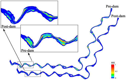
FIGURE 7. Habitat suitability index numerical distribution map during the pre- and post-dam period at the Xiaolangdi Reservoir on the Yellow River, China.
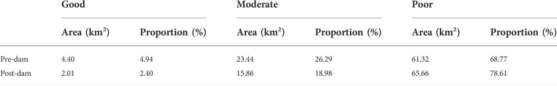
TABLE 5. Habitat model results: area and proportion of total area during the pre- and post-dam period at the Xiaolangdi Reservoir on the Yellow River, China. Habitat suitability index values were classified as follows: 0–0.3 was poor, 0.3–0.5 was moderate, and 0.5–1 was good.
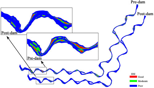
FIGURE 8. Habitat suitability index values were classified as good, moderate, or poor during the pre- and post-dam period at the Xiaolangdi Reservoir on the Yellow River, China.
5 Discussion
From the simulation results, it can be seen that the dam construction restricted the reproduction of Yellow River carp (Cooper et al., 2017; Quan et al., 2021; Xing et al., 2021), resulting in a significant effect on the spawning activity of the Yellow River carp, and the WUA for spawning was reduced by 45.53%, which was consistent with the existing research conclusions. Wang et al. (2020), Shang et al. (2020) and Jiang et al. (2009, 2010) found that the habitat area of the Yellow River carp tended to be stable when the flow velocity exceeded 1,000 m3/s, and the runoff components suitable for spawning of the Yellow River carp decreased significantly after the completion of the Xiaolangdi Reservoir, which had a negative effect on their reproductive activities. On this basis, the ecological flow of the lower reaches of the Yellow River was proposed. Zhang et al. (2008) obtained the same conclusion through qualitative inference analysis. In this paper, the influence is quantitatively described by combining the typical annual spawning period unsteady flow and suitability curve.
Regarding the selected three main habitat influencing factors, previous studies show that the effect of flow pulse on the habitat of Yellow River carp cannot be ignored. If only the two habitat factors of flow velocity and water depth are considered, and the spatial distribution of the regional HSI before and after the dam construction is calculated, the WUA of the habitat before the dam construction is 221.32 km2 and is reduced to 214.11 km2 after the dam construction, which is 3.25% less than the WUA before the dam construction. When compared with the reduction in water level rise of 45.53% found in this study, the influence of water level rise is shown to be considerable. The reason is that if the effect of water level rise is not considered, the stimulation signal of the flow pulse on fish spawning will be ignored. At the same time, the contribution of the rising river water to the expansion of the Yellow River carp habitat area of, which provides spawning areas, more food sources for spawning activities, and the growth of young fish will be weakened (Yin et al., 2011; Timpe and Kaplan, 2017), resulting in a decline in habitat suitability of Yellow River carp.
In addition, the change of regional runoff components caused by dam construction also affects fish habitat (Ge et al., 2022). Huayuankou is the starting point for the Yellow River to become a suspended river, where the river bed is raised several meters above the surrounding ground. The historical data of Huayuankou Station were statistically analyzed. Flow pulses often occurred before the dam construction of the Xiaolangdi Reservoir. The peak flow can reach approximately 3,000 m3/s, and the minimum flow is approximately 500 m3/s. Because of the influence of water-sediment regulation after dam construction, the peak flow decreased, the flow pulse decreased greatly or even disappeared, and the flow range was approximately 500–2000 m3/s. The empirical frequency curve of daily average flow at Huayuankou Station from 1960 to 2018 was plotted (Figure 9). After the completion of Xiaolangdi Reservoir, floods with a frequency of less than 10% were significantly reduced, and small floods or flood pulses with frequencies of 10–40% were also reduced. For the low flow process with a frequency greater than 80%, the variation is small. The flow frequency suitable for the Yellow River carp habitat decreased significantly, which had a negative effect on the spawning activities of Yellow River carp.
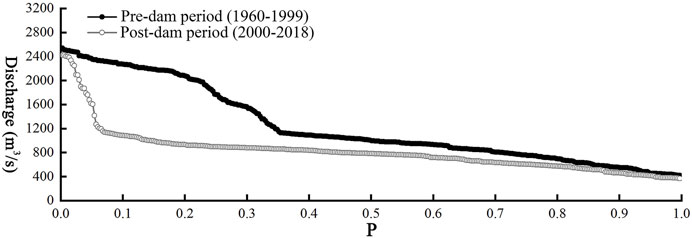
FIGURE 9. Empirical frequency curve of daily flow at Huayuankou Station on the Yellow River, China.
Dam construction has been studied and discussed by many scholars because of its obvious ability to disturb river hydrological conditions. However, dam construction and water storage are not the only human disturbance in the study area. Activities such as agriculture and animal husbandry also have a great effect on aquatic habitats and water quality (Zaiatz et al., 2018). We analyzed the effect of a single reservoir—the Xiaolangdi Reservoir—on the habitat of Yellow River carp, but this study ignores the synergistic effects of the construction of multiple hydropower stations in the same basin on the biological community. In areas that have multiple hydropower stations, each station acts as a nutritional filter, changing the physical and chemical properties of the river as well as preventing the entry of migratory species (Barbosa et al., 1999; Miranda et al., 2008). Future studies must consider how to comprehensively consider the habitat factors affecting the habitat suitability of Yellow River carp.
6 Conclusion
In this paper, a two-dimensional hydrodynamic model coupled with a habitat suitability model was used to explore the effect of the construction of the Xiaolangdi Reservoir on the spawning activity of Yellow River carp, the key species in the lower reaches of the Yellow River. The conclusions are as follows:
1) By constructing a two-dimensional hydrodynamic model and pairing it with a habitat suitability model of the Yellow River carp spawning ground, the spatial distribution of the HSI of the Yellow River carp was statistically analyzed, and the WUA of the Yellow River carp was calculated to evaluate the habitat quality change of the Yellow River carp after the construction of the Xiaolangdi Reservoir.
2) The construction of the reservoir reduced the WUA of the Yellow River carp by 83.93 km2, which was 45.53% lower than that of the natural habitat.
3) The construction of the reservoir has changed the hydrological conditions of the river. The decrease in water level rise and the reduction or even elimination of the flow pulse have weakened the stimulating effect on the spawning of aquatic organisms and have seriously affected the habitat of the Yellow River carp.
Data availability statement
The original contributions presented in the study are included in the article/Supplementary Material, further inquiries can be directed to the corresponding author.
Author contributions
HB: Data curation, Formal analysis, Methodology, Software, Writing—Original Draft. SZ: Resources, Conceptualization, Writing—Reviewing and Editing, Supervision, Funding acquisition, Project administration. CT: Methodology and Validation. XY: Methodology and Formal analysis.
Funding
This study was supported by the National Natural Science Foundation of China (52061135104), and the Fundamental Research Funds for the Central Universities (2022YQ004).
Acknowledgments
We thank Clio Reid, from Liwen Bianji (Edanz) (www.liwenbianji.cn/) for editing the English text of a draft of this manuscript.
Conflict of interest
The authors declare that the research was conducted in the absence of any commercial or financial relationships that could be construed as a potential conflict of interest.
Publisher’s note
All claims expressed in this article are solely those of the authors and do not necessarily represent those of their affiliated organizations, or those of the publisher, the editors and the reviewers. Any product that may be evaluated in this article, or claim that may be made by its manufacturer, is not guaranteed or endorsed by the publisher.
References
Andreia Dos Santos, J., Barbosa Silva, C., Soares De Santana, H., Cano-Barbacil, C., Agostinho, A. A., Normando, F. T., et al. (2022). Assessing the short-term response of fish assemblages to damming of an Amazonian river. J. Environ. Manage. 307, 114571. doi:10.1016/j.jenvman.2022.114571
Ban, X., Du, Y., Liu, H., and Ling, F. (2011). Applying instream flow incremental method for the spawning habitat protection of Chinese Sturgeon (Acipenser sinensis). River Res. Appl. 27, 87–98. doi:10.1002/rra.1341
Barbosa, F., Padisak, J., Espíndola, E., Borics, G., and Rocha, O. (1999). The cascading reservoir continuum concept (CRCC) and its application to the river Tietê-basin. São Paulo State, Brazil: Theoretical Reservoir Ecology and Its Applications, 425–437.
Bouaroudj, S., Menad, A., Bounamous, A., Ali-Khodja, H., Gherib, A., Weigel, D. E., et al. (2019). Assessment of water quality at the largest dam in Algeria (Beni Haroun Dam) and effects of irrigation on soil characteristics of agricultural lands. Chemosphere 219, 76–88. doi:10.1016/j.chemosphere.2018.11.193
Bunn, S. E., and Arthington, A. H. (2002). Basic principles and ecological consequences of altered flow regimes for aquatic biodiversity. Environ. Manage. 30, 492–507. doi:10.1007/s00267-002-2737-0
Cao, Y., Wang, C., and Qian, D. (2022). Influence of cascaded hydropower development on high and low flows in the spawning grounds of the four major Chinese carps. J. Hydroecology 43, 18–26. doi:10.15928/j.1674-3075.202011130323
Chen, D., Xiong, F., Wang, K., and Chang, Y. (2009). Status of research on Yangtze fish biology and fisheries. Environ. Biol. Fish. 85, 337–357. doi:10.1007/s10641-009-9517-0
Chen, M., Feng, H., Wang, L., and Chen, Q. (2007). Calculation methods for appropriate ecological flow. Adv. Water Sci. 18, 745–750. doi:10.14042/j.cnki.32.1309.2007.05.010
Collier, J. J., Chiotti, J. A., Boase, J., Mayer, C. M., Vandergoot, C. S., and Bossenbroek, J. M. (2022). Assessing habitat for lake sturgeon (Acipenser fulvescens) reintroduction to the Maumee River, Ohio using habitat suitability index models. J. Gt. Lakes. Res. 48, 219–228. doi:10.1016/j.jglr.2021.11.006
Cooper, A., Infante, D., Daniel, W., Wehrly, K., Wang, L., and Brenden, T. (2017). Assessment of dam effects on streams and fish assemblages of the conterminous USA. The Science of the total environment, 586.
Duan, X., Chen, D., Li, Z., Wang, K., Huang, M., and Liu, S. (2008). Current status of spawning grounds of fishes with pelagic eggs in the middle reaches of the Yangtze River after impoundment of the Three Gorges Reservoir. J. Fish. Sci. China 15, 523–531. doi:10.3321/j.issn:1005-8737.2008.04.001
Fukuda, S. (2009). Consideration of fuzziness: Is it necessary in modelling fish habitat preference of Japanese medaka (Oryzias latipes)? ECOL. Ecol. Modell. 220, 2877–2884. doi:10.1016/j.ecolmodel.2008.12.025
Ge, L., Zhou, Z., Shen, H., Huang, Y., and Wang, Y. (2022). Effect of ecological flow regulation on fish diversity in the lower Yellow River. Yellow River 44, 115–120. doi:10.3969/j.issn.1000-1379.2022.05.023
Hoeinghaus, D., Agostinho, A., Gomes, L., Pelicice, F., Okada, E., Latini, J., et al. (2009). Effects of river impoundment on ecosystem services of large tropical rivers: Embodied energy and market value of artisanal fisheries. Conserv. Biol. 23, 1222–1231. doi:10.1111/j.1523-1739.2009.01248.x
Hui, J., Jie, Z., He, H., Zhou, X., Wang, Z., Zhu, W., et al. (2019). Spawning ground status of fish that release benthic eggs in the henan section of Yellow River. J. Hydroecology 40, 108–114. doi:10.15928/j.1674-3075.2019.04.014
Jiang, X., Angela, A., and Liu, C. (2009). Environmental flow requirements by major fishes in the lower reach of the yellow river determined by flow restoration. J. Beijing Normal Univ. Nat. Sci. 45, 537–542. doi:10.3321/j.issn:0476-0301.2009.05.018
Jiang, X., Liu, X., Zhang, S., and Cai, Q. (2005). Distinguishing key species of aquatic ecosystem of the main Yellow River. Yellow River, 27, 1–3.
Jiang, X., Zhao, W., and Zhang, W. (2010). The impact of Xiaolangdi Dam operation on the habitat of Yellow River Carp (Cyprinus (Cyprinus) carpio haematopterus Temminck et Schlegel). Acta Ecol. Sin. 30, 4940–4947.
Li, C., Peng, J., and Liao, W. (2006). Study on the eco-hydrological factors and flow regime requirement on spawning of four major Chinese carps in the middle reaches of Yangtze River. J. China Inst. Water Resour. Hydropower Res. 4, 170–176. doi:10.13244/j.cnki.jiwhr.2006.03.002
Li, J., and Xia, Z. (2011). Study on instream ecological flow of the middle Yangtze River based on physical habitat simulation. J. Hydraulic Eng. 42, 678–684. doi:10.13243/j.cnki.slxb.2011.06.007
Li, Q., Qin, H., Chen, G., and Wang, B. (2012). Analysis on hydrologic alteration of middle Yangtze River and its impact on fish. Yangtze River 43, 86–89. doi:10.16232/j.cnki.1001-4179.2012.11.003
Linhoss, A. C., Muñoz-Carpena, R., Allen, M. S., Kiker, G., and Mosepele, K. (2012). A flood pulse driven fish population model for the Okavango Delta, Botswana. Ecol. Modell. 228, 27–38. doi:10.1016/j.ecolmodel.2011.12.022
Luo, Z., Shao, Q., and Liu, H. (2021). Comparative evaluation of river water quality and ecological changes at upstream and downstream sites of dams/sluices in different regulation scenarios. J. Hydrology 597, 126290. doi:10.1016/j.jhydrol.2021.126290
Macklin, M. G., Brewer, P. A., Balteanu, D., Coulthard, T. J., Driga, B., Howard, A. J., et al. (2003). The long term fate and environmental significance of contaminant metals released by the January and March 2000 mining tailings dam failures in Maramureş County, upper Tisa Basin, Romania. Appl. Geochem. 18, 241–257. doi:10.1016/s0883-2927(02)00123-3
Marchamalo, M., Bejarano, M., Garcia De Jalon, D., and Marin, R. (2007). Fish habitat characterization and quantification using LIDAR and conventional topographic information in river survey. Proc. SPIE 6742, 6742. doi:10.1117/12.737803
Miranda, L., Habrat, M., and Miyazono, S. (2008). Longitudinal gradients along a reservoir cascade. Trans. Am. Fish. Soc. 137, 1851–1865. doi:10.1577/t07-262.1
Poff, N., Allan, J. D., Bain, M., Karr, J., Prestegaard, K., Richter, B., et al. (1997). The natural flow regime: A paradigm for river conservation and restoration. BIOSCIENCE 47, 769–784. doi:10.2307/1313099
Quan, Q., Gao, S., Shang, Y., and Wang, B. (2021). Assessment of the sustainability of Gymnocypris eckloni habitat under river damming in the source region of the Yellow River. Sci. Total Environ. 778, 146312. doi:10.1016/j.scitotenv.2021.146312
Richter, B., Baumgartner, J., Powell, J., and Braun, D. (1996). A method for assessing hydrologic alteration within ecosystems. Conserv. Biol. 10, 1163–1174. doi:10.1046/j.1523-1739.1996.10041163.x
Shang, W., Peng, S., Wang, Y., Zheng, X., Wu, J., and Liu, B. (2020). Research on the ecological integrity-oriented environmental flow regime of the Lower Yellow River. J. Hydraulic Eng. 51, 367–377. doi:10.13243/j.cnki.slxb.20190784
Sousa, R. G. C., de Freitas, H. C. P., Zacardi, D. M., and Faria-Junior, C. H. (2021). Effects of river dams on the fish guilds in the northwest region of the Brazilian Amazon. Fish. Res. 243, 106091. doi:10.1016/j.fishres.2021.106091
Tiemann, J. S., Gillette, D. P., Wildhaber, M. L., and Edds, D. R. (2004). Effects of lowhead dams on riffle-dwelling fishes and macroinvertebrates in a midwestern river. Trans. Am. Fish. Soc. 133, 705–717. doi:10.1577/T03-058.1
Timpe, K., and Kaplan, D. (2017). The changing hydrology of a dammed Amazon. Sci. Adv. 3, e1700611. doi:10.1126/sciadv.1700611
Tundisi, J. (2018). Reservoirs: New challenges for ecosystem studies and environmental management. Water Secur. 4-5, 1–7. doi:10.1016/j.wasec.2018.09.001
Vincenzi, S., Caramori, G., Rossi, R., and De Leo, G. (2006). A GIS-based habitat suitability model for commercial yield estimation of Tapes philippinarum in a Mediterranean coastal lagoon (Sacca di Goro, Italy). Ecol. Modell. 193, 90–104. doi:10.1016/j.ecolmodel.2005.07.039
Wang, C., Xie, S., Wang, J., and Huang, D. (2014). Investigation of fish resources in longtan reservoir of hongshuihe river. J. Hydroecology 35, 39–48. doi:10.15928/j.1674-3075.2014.02.005
Wang, H., and Yin, Z. (2019). Effects of hydrological regime variation in the upper Yangtze River on spawning of Coreius heterodon in the National Reserve. Yangtze River 50, 46–50. doi:10.16232/j.cnki.1001-4179.2019.12.009
Wang, R., Huang, J., Ge, L., Feng, H., Li, R., and Shen, H. (2020). Study of ecological flow based on the relationship between cyprinusy carpio habitat hydrological and ecological response in the lower Yellow River. J. Hydraulic Eng. 51, 1175–1187. doi:10.13243/j.cnki.slxb.20200184
Wang, S., Liao, W., Chen, D., Duan, X., Peng, Q., Wang, K., et al. (2008). Analysis of eco-hydrological characteristics of the four Chinese farmed carps' spawning grounds in the middle reach of the Yangtze river. Resour. Environ. Yangtze Basin 17, 892–897. doi:10.3969/j.issn.1004-8227.2008.06.012
Wang, Y., Tang, M., and Dai, H. (2016). Analysis on correlation between suitability of spawning habitat for four major Chinese carps and discharge from dam. Water Resour. Hydropower Eng. 47, 107–112. doi:10.13928/j.cnki.wrahe.2016.01.024
Xing, Y., Lv, B., Ma, D., Zhang, H., and Yu, G. (2021). Hydrodynamic modeling to evaluate the influence of inland navigation channel training works on fish habitats in the Upper Yellow River. Ecol. Eng. 169, 106289. doi:10.1016/j.ecoleng.2021.106289
Xu, Z., Wang, H., Chen, M., Tang, K., and Wang, Y. (2005). Research on methods of minimum ecological water requirements in river based on analysis of ecosystem (-). Water Resour. Hydropower Eng. 36, 31–34. doi:10.13928/j.cnki.wrahe.2005.01.009
Yang, L., Hou, J., Cheng, L., Wang, P., Pan, Z., Wang, T., et al. (2021). Application of habitat suitability model coupling with high - precision hydrodynamic processes. Ecol. Model. 462, 109792. doi:10.1016/j.ecolmodel.2021.109792
Yi, Y., Hou, C., Tang, C., and Song, J. (2019). Habbitat simulation of tor sinensis in middle reaches of langcang river. Water Resour. Hydropower Eng. 50, 82–89. doi:10.13928/j.cnki.wrahe.2019.05.010
Yin, X., Yang, Z., and Petts, G. E. (2011). Reservoir operating rules to sustain environmental flows in regulated rivers. Water Resour. Res. 47, W08509. doi:10.1029/2010wr009991
Zaiatz, A., Zolin, C., Vendrusculo, L., Lopes, T., and Paulino, J. (2018). Agricultural land use and cover change in the cerrado/amazon ecotone: A case study of the upper teles pires River Basin. Acta Amaz. 48, 168–177. doi:10.1590/1809-4392201701930
Zhang, M., Zhang, Y., Zhu, W., Liao, C., and Zhao, S. (2010). Wetland restoration models in Zhengzhou Yellow River nature reserve, henan province. Wetl. Sci. 8, 67–73. doi:10.13248/j.cnki.wetlandsci.2010.01.014
Zhang, W., Huang, Q., and Jiang, X. (2008). Study on instream ecological flow based on physical habitat simulation. Adv. Water Sci. 19, 192–197. doi:10.14042/j.cnki.32.1309.2008.02.009
Keywords: habitat suitability model, Xiaolangdi reservoir, Yellow river carp (Cyprinus carpio), two-dimensional hydrodynamic model, spawning ground
Citation: Bao H, Zhang S, Tang C and Yang X (2022) Effect of dam construction on spawning activity of Yellow River carp (Cyprinus carpio) in the lower Yellow River. Front. Earth Sci. 10:975433. doi: 10.3389/feart.2022.975433
Received: 22 June 2022; Accepted: 01 August 2022;
Published: 29 August 2022.
Edited by:
Weili Duan, Xinjiang Institute of Ecology and Geography (CAS), ChinaReviewed by:
Huaiwei Sun, Huazhong University of Science and Technology, ChinaChao Liu, Sichuan University, China
Copyright © 2022 Bao, Zhang, Tang and Yang. This is an open-access article distributed under the terms of the Creative Commons Attribution License (CC BY). The use, distribution or reproduction in other forums is permitted, provided the original author(s) and the copyright owner(s) are credited and that the original publication in this journal is cited, in accordance with accepted academic practice. No use, distribution or reproduction is permitted which does not comply with these terms.
*Correspondence: Shanghong Zhang, emhhbmdzaDkyOEAxMjYuY29t