 Guanbo Zhou
 Xiang Fang1*
 Jie Cao
95% of researchers rate our articles as excellent or good
Learn more about the work of our research integrity team to safeguard the quality of each article we publish.
Find out more
ORIGINAL RESEARCH article
Front. Earth Sci. , 01 September 2022
Sec. Atmospheric Science
Volume 10 - 2022 | https://doi.org/10.3389/feart.2022.974497
This article is part of the Research Topic AI-Based Prediction of High-Impact Weather and Climate Extremes under Global Warming: A Perspective from The Large-Scale Circulations and Teleconnections View all 21 articles
In recent years, with the emergence of new artificial intelligence (AI) technology and more observational data from automatic meteorological stations, radars and satellites, the deep learning has very broad application scenarios in the context of meteorological big data. The deep learning has powerful data learning ability and feature capturing ability of complex structures, which has now occupied an important position in the meteorological field and also become a hot topic in meteorological research. Especially, AI has shown great potential advantages in image recognition, which can provide new ideas and new directions for typhoon monitoring and forecasting. In this study, the data used include the typhoon best track data set provided by the China Meteorological Administration and the Himawari-8 and FY4 satellite image data from 2005 to 2020. We use the deep learning model to conduct the typhoon vortex identification, the determination of typhoon location and intensity, and the detection of typhoon intensity mutation with AI techniques. The main research content includes a typhoon vortex identification model based on deep image target detection, an intelligent typhoon intensity determination model based on image classification and retrieval, and a typhoon rapid intensification identification model. Then, a typhoon intelligent monitoring and forecasting system is constructed. The results show that the system can correctly identify typhoon vortices above the strong tropical storm grade in a percentage of 88.6%. The mean absolute error (MAE) and Root mean square deviation (RMSE) of typhoon intensity estimation are 3.8 m/s and 5.05 m/s, respectively, and the comprehensive accuracy of rapid intensification estimation of annual independent samples reaches 92.0%. The system is capable of performing the automatic identification, location and intensity determination, and intelligent tracking of tropical cyclones in real time by using high spatial and temporal resolution satellite images. This study may help further improve the operational techniques for typhoon monitoring and forecasting.
Typhoon disaster is one of the natural disasters with the highest frequency and the most serious impact in the world (Chen et al., 2004, 2006; Duan et al., 2020). China is located on the west coast of the Pacific Ocean. The coastal provinces affected by typhoon activities are densely populated and economically developed, and are also the most vulnerable to typhoon disasters (Chen, 2010; Xu et al., 2010; Zhang et al., 2010; Wu et al., 2017). It poses a serious threat to the socio-economic development of China (Lei et al., 2009; Duan, et al., 2012, 2014). In particular, with the global warming, the probability and proportion of typhoon enhancement in the Northwest Pacific are on the rise (Emanuel, 2005; Webster et al., 2005; Wu et al., 2022). The increase of typhoon intensity and strong typhoon frequency and the low moving speed result in a longer impact time and stronger intensity of landing typhoons. The hazards brought by typhoons are gradually increasing, leading to more casualties and property damage. Moreover, the prevention of typhoons is becoming more and more difficult. With the rapid development of artificial intelligence (AI), as a means of artificial intelligence, machine learning has been proved to become a new method to overcome the bottleneck of typhoon prediction (Chen and Chavas. 2020). To be specific, the machine learning is used to conduct the fusion of satellite data, radar data and numerical model outputs, so as to improve the forecast performance on typhoon intensity and wind field structure (Chen and Chavas. 2020).
Moreover, the deep learning has also been gradually applied in the assessment and prediction of typhoon intensity. Wimmers et al. (2019) used the convolutional neural network to estimate typhoon intensity based on satellite cloud pictures. Wang et al. (2015) predicted TC (Tropical Cyclone) intensity according to the artificial neural network. Baik and Paek (2000) used the back-propagation (BP) algorithm to optimize the multilayer perceptron Multi-layer Perceptron (MLP) network and established a 12–72 h forecast model on TC intensity in the Northwest Pacific. Through the application of the multidimensional predictors same as the multiple linear regression model (MLR), the average error of MLP model is reduced by 7%–16% compared with that of MLR model. Chaudhuri et al. (2013) also used MLP to predict typhoon intensities. They used the variables such as central pressure, maximum sustained surface wind speed, pressure drop, total atmospheric ozone column and sea surface temperature as the input matrix of the model, and found that the minimum prediction error of the model is 4.07%. Since the intensity variation of typhoon can be considered as a time series, the recursive neural networks (RNN) can be used in the modeling of temporal dynamic behavior. Pan et al. (2019) constructed 24–48 h prediction models by using RNN. The model has a better performance in reducing the final error compared to the traditional dynamic model. The average error is 5.1 m s−1 for 24 h prediction and 6.7 m s−1 for 48 h prediction. Chen et al. (2019) established a convolutional neural network and a long short-term memory neural network model, which focused on the spatio-temporal correlation of atmospheric and oceanic variables. The error of this model is smaller than those of some existing numerical models, statistical models and traditional machine learning methods. In addition, Jin et al. (2020) studied the relationship between remote sensing data and TC intensity, and developed a “ring segmentation method” to extract satellite data features. Then, using a gradient enhancement model-XGBoost model, they established a typhoon intensity prediction model for the South China Sea based on FY-2 satellite data, environmental data and typhoon best track dataset. Generative adversarial networks combined with long and short-term memory networks are used to solve the problem of satellite cloud-image sequence prediction (Xu et al., 2019). A research group from the Japan Agency for Marine Research and the Kyushu University jointly developed a method to identify tropical depression clouds with high accuracy from the Global Cloud System Resolution Model climate experiment data. The method can identify the signs a week before the occurrence of tropical depressions in the Northwest Pacific Ocean in summer. Meanwhile, it can predict typhoon paths and intensities, and the occurrence of heavy rainfall (Matsuoka et al., 2018). Further studies have shown that deep learning algorithms can also be well integrated with model forecast data. Hurricane-WRF is a widely used typhoon forecast model in numerical simulation studies, and its forecast output can be well integrated with feedforward neural networks (FFNN) for TC intensity prediction, especially for the typhoons with rapid intensification (Cloud et al., 2019). The output meteorological analysis field from the global forecast system (GFS) can drive the Bayesian model to conduct TC intensity prediction (Schaffer et al., 2020).
In order to improve typhoon monitoring and forecasting capabilities and serve national sustainable development and disaster prevention and mitigation, this study chooses several AI-based deep learning models based and applies them in operational typhoon monitoring and forecasting. The models include a typhoon vortex identification model based on deep image target detection, an intelligent typhoon intensity determination model based on image classification and retrieval, and a typhoon rapid intensification discrimination model based on spatio-temporal sequence features. Based on the aforementioned models, a whole set of AI-based typhoon monitoring and forecasting system is proposed in this study. In the next two sections, both data and models are described followed by the design and applications of AI-based system in Section 4. The problems of the current AI techniques in typhoon monitoring and forecasting applications and the outlook of future work are discussed in the last section.
The TC data used in this paper include the best track dataset from 2005 to 2021 (http://tcdata.typhoon.org.cn/zjljsjj_sm.html) provided by Shanghai Typhoon Research Institute, China Meteorological Administration. This data set includes the position of TC once every 6 h, the lowest central air pressure, the maximum wind speed near the center, etc. The Himawari-8 satellite data from 2005 to 2017 were selected as the training set, the satellite data from 2018 as the validation set, and the FY4A satellite data from 2019 to 2021 as the test set. The horizontal resolution of the satellite cloud map is 0.05°. Based on the best typhoon path information compiled by the Shanghai Typhoon Research Institute of China Meteorological Administration, a 400 × 400 pixel cloud map (about 2000 × 2000 km) of the typhoon center at the corresponding moment is intercepted, and the sample labels are labeled according to the real typhoon intensity in the best path as the training set of deep learning data samples (15730 cloud maps in total).
In order to build an artificial intelligence-based typhoon monitoring and forecasting system to achieve automated and objective localization, intensity determination and intensity trend discrimination of tropical cyclones, this paper mainly selects a typhoon vortex identification model based on deep image target detection, a typhoon intelligent intensity determination model based on image classification and retrieval, and a typhoon fast enhancement discrimination model incorporating spatio-temporal sequence features.
Using the satellite cloud map and the best typhoon path information to construct a large sample annotated data set, the classical target detection SSD (Single Shot MultiBox Detector) model with fast operation and high recognition accuracy in the field of artificial intelligence is used as the base model for typhoon vortex recognition, and the model is modified to propose an iterative SSD target detection model for the uniqueness of typhoon vortex recognition, especially the difficulty of weak vortex recognition (Figure 1). SSD model of target detection is a one-stage multi frame detection model. Because of its fast running speed and high recognition rate, SSD model is the most widely used basic model of target detection at present. SSD model adopts the method of multi-scale feature mapping, using six convolution blocks with different scale sizes to convolute images with different scales, so as to detect target objects with different sizes. The satellite raw data is converted into a disk map, and the disk map is cropped into an 1800*1800 area image according to the area to be monitored, and the 1800*1800 area image is labeled with data to perform vortex recognition and localization of the cloud map by the model of the trained SSD.
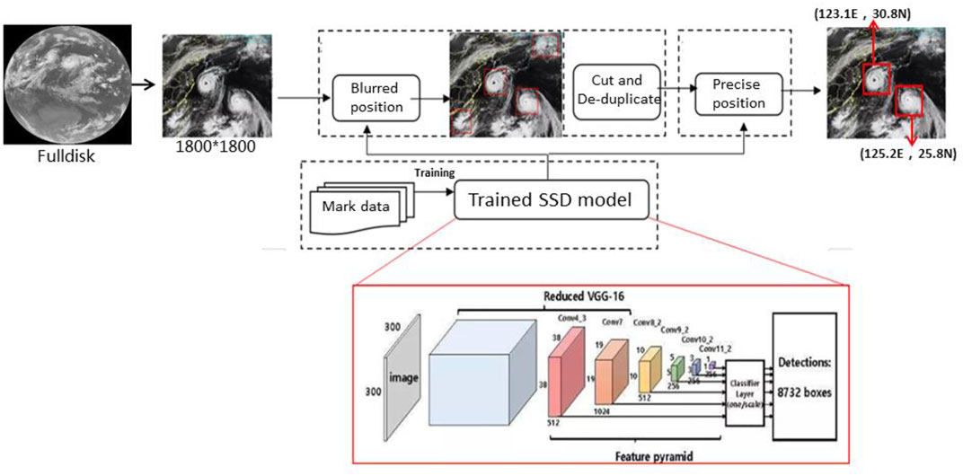
FIGURE 1. Flowchart of vortex recognition model based on depth image target detection.
According to the best typhoon track data, the images are marked one by one. Firstly, we read the best track file, get the list of files to be labeled, find the corresponding best track, and generate a label file, so as to build a large sample label data set. The construction of sample label data set is a very time-consuming and labor-intensive task, and it is also the primary key work in the research and development of this technology. The sample data set includes typhoon samples of all levels (tropical depression, tropical storm, severe tropical storm, typhoon, strong typhoon and super typhoon). From the specific sample distribution number of each wind speed, the sample size of severe tropical storm is the largest, while the sample size of tropical depression and super typhoon is the smallest. In addition, if a picture contains multiple images with different intensity levels, each typhoon vortex will be labeled, so the total number of samples will be more than the original 1800 × 1800 samples. After a lot of processing above, the target monitoring data set of Typhoon Vortex recognition is finally constructed.
According to the experimental results as follows, the thresholds of 0.2 and 0.7 were selected respectively. Firstly, fuzzy localization is performed by inputting 1800 × 1800 size, performing the first round of detection and coarse localization with 0.2 lower confidence threshold, de-weighting the output results based on the center distance, and intercepting 640 × 640 images as the second round of input with the center of localization as the origin; then precise localization is performed: inputting 640 × 640 size, performing recognition with 0.7 higher confidence threshold, de-weighting the second time, and The 400 × 400 final output image is further intercepted, which is used to finely localize the vortex and output the final vortex localization results (latitude and longitude coordinates with confidence scoring).
The iterative model (after improvement) and the non-iterative model (before improvement) were tested using 2020 data (Figure 2), with a total of 702 samples. The experimental results show that, compared with the non-iterative model, the iterative model has a better recognition effect at all typhoon intensity levels, significantly improving the recognition ability of vortices at typhoon level and below, and the correct recognition rate of vortices at tropical depression and tropical storm level and below. The correct recognition rate is 40%–80%, which is a significant improvement to the original SSD model (the original correct recognition rate is only 15%–50%), and the correct recognition rate of typhoon vortices of strong tropical storm level and above is over 90%.
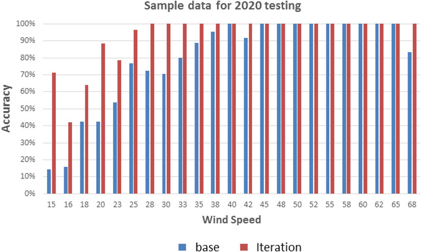
FIGURE 2. Vortex recognition rate test results (blue columns represent non-iterative algorithm; red columns represent iterative algorithm).
According to the best track data (location and moment) at an interval of 1, 3 or 6 h, the 400*400 pixel cloud image of the typhoon center at the corresponding time is intercepted as the cloud image data set of deep learning, with a total of 15730 samples. From the wind speed distribution in the typhoon data set, we can see that the distribution of each wind speed is not uniform, in which the number of wind speeds such as 18 m/s, 20 m/s, 22 m/s, 25 m/s is significantly more than other wind speeds, while the number of wind speeds with particularly low values (such as 10 m/s, 12 m/s, 13 m/s, etc.) and wind speeds with particularly high values (such as 68 m/s, 70 m/s, 72 m/s, etc.) is significantly less. We divided each wind speed into the training set and the test set according to the ratio of 7:3, so as to ensure that the model can learn the characteristics of typhoons with different wind speeds. There are 12550 samples in the final training set and 3138 samples in the test set.
Due to the unbalance sample data of typhoon intensity, this paper uses the data enhancement technology commonly used in machine learning to improve to a certain extent. The goal of data enhancement is to increase the training data to prevent over fitting and enhance the generalization ability of the model. The main methods are rotation, flip and crop and so on (Qian et al., 2021).
Deep learning, which can implicitly extract deep abstract complex features in images through machine analysis and learning of a large number of samples, is increasingly applied to the field of estimating typhoon intensity. In order to achieve intelligent typhoon intensity determination, we introduce an end-to-end dual estimation Pipeline deep typhoon intensity determination model (Figure 3), which is a technical model for typhoon intensity determination based on image classification and retrieval, based on mature pre-trained CNN (convolutional neural network) deep learning models in the field of computer vision, such as: ResNet, VGG (Visual Geometry Group), etc., to perform typhoon intensity related to satellite cloud image data Based on the extracted features, a classification model (regression depth model) and a similarity-based retrieval model (visualization retrieval model) are constructed respectively to obtain the decision results, and finally the recognition results of the two models are fused (fusion module) to give the final top three typhoon strengths with the highest confidence level, the confidence level and the corresponding reference satellite cloud images.

FIGURE 3. Flowchart of the intelligent intensity determination model of typhoon based on image classification and retrieval.
Here we select the two most commonly used indicators which can reflect the error between the estimated value and the real value to measure accuracy of AI models.
Mean absolute error of wind speed estimation:
Root mean square error of wind speed estimation:
Here
For a full-year sample of 2020, the MAE and RMSE of the ResNet model in determining the typhoon intensity are 3.8 m/s and 5.05 m/s, respectively (Figure 4). Compared with the results of Pradhan et al. (2018) who used a deep CNN model to conduct the intensity estimation of 68 TCs over the Atlantic Ocean and 30 TCs over the Pacific Ocean (their independent samples have a RMSE of about 5.84 m/s), the ResNet model in this study has a slight advantage. Compared with the traditional statistical method for typhoon intensity estimation from satellite cloud images (Lu et al., 2014), which has a RMSE of 7.7 m/s for independent samples, the ResNet model in this study has a clear advantage. It has a good reference value for the objective determination of typhoon intensity.
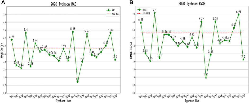
FIGURE 4. MAE (A) and RMSE (B) of the ResNet model for smart intensity determination of typhoons for the annual sample intensity estimation in 2020.
The cloud chart samples for 2020 are classified into 6 classes according to the maximum average wind speed near the center of TC, which are tropical depression, tropical storm, strong tropical storm, typhoon, strong typhoon, and super typhoon class (Table 1), containing a total of 868 samples. When the maximum average wind speed near the bottom center of a tropical cyclone reaches 10.8 m/s–17.1 m/s, it is a tropical depression, when it reaches 17.2 m/s–24.4 m/s, it is a tropical storm, when it reaches 24.5 m/s–32.6 m/s, it is a strong tropical storm, when it reaches 32.7 m/s–41.4 m/s, it is a typhoon, and when it reaches 41.5 m/s–50.9 m/s, it is a strong typhoon, It is a super typhoon if it reaches or exceeds 51.0 m/s. From the MAE and RSME of the samples of each class, the model has the best estimation for the samples of tropical depression and tropical storm, whose MAE and RSME are both the smallest. The MAE for the samples of tropical storm is 2.66 m/s, and the MAE for tropical depression is 3.12 m/s, and its intensity estimation ability has reached the level for operational reference. The model is less effective in estimating typhoon-class samples, with the estimated MAE reaching 6.16 m/s and RSME reaching 7.81 m/s. Therefore, subjective revisions and analyses by forecasters are required for such typhoons in operational terms.
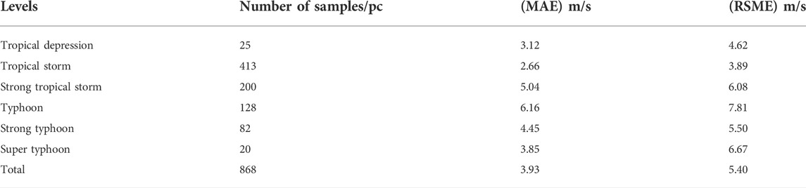
TABLE 1. AI Model analysis of the intensity estimation of the 2020 typhoon cloud samples.
According to the sample statistics from 2005 to 2018, it was found that the RI cases account for less than 5% of all typhoon cases. Generally, for a data set, if the target event is few and the proportion is less than 10%, it is called an extremely imbalanced data set. For imbalanced data sets, machine learning algorithms often fail to achieve satisfactory classification results. In order to increase the number of RI cases, to increase the number of positive samples of a few categories, to and reduce the number of negative samples of most categories, we defined the cases with an increase of typhoon speed by more than 7 m/s within 12 h as the positive samples of typhoon RI. In the training process, although the number of positive samples increased by adopting the new threshold of RI (wind speed increases by 7 m/s in 12 h), the ratio of positive samples to negative samples in the whole data set (with RI samples as positive samples and non-RI samples as negative samples) was still about 1:11. As the positive and negative samples were not evenly distributed, a re-weighting method was applied to the training data (Zhou et al., 2022). Weighting means giving different punishments to imbalanced categories. Different weights were applied to the loss (the difference between the model predicted value and the true value of the sample) calculated by different categories in the training process, so that the model optimization tended to favor the few categories (RI samples).
where
In order to realize the objective discrimination of the intensity change trend of TCs, an automatic and objective technique for rapid enhancement trend discrimination of typhoons is proposed based on the deep residual network ResNet model and the spatio-temporal correlation deep learning model LSTM in the field of artificial intelligence, and the life cycle indication is introduced by labeling and learning the key information in satellite cloud map data, which can effectively solve the typhoon intensity The problem of predicting and discriminating the rapid intensification trend is effectively solved. The technical route of the typhoon rapid intensification discrimination model incorporating spatio-temporal sequence features is shown in Figure 5. In the 1800*1800 regional image after satellite data resolution, the typhoon life cycle is marked every 6 h according to the best path file, and a 400*400 vortex image sequence is cropped. After that, the image sequence and the marked life cycle are fed into the model for trend discrimination of whether the typhoon is rapidly intensifying after 12 h, which improves the accuracy of predicting and discriminating the trend of rapid typhoon intensity intensification.

FIGURE 5. Flow chart of the fast enhancement discriminative model for typhoons incorporating spatial and temporal sequence features.
Taking Typhoon No.2114 “Chanthu” in 2021 as an example (Figure 6), the number of information on the optimal path is 166, and by labeling the 166 information, a total of 9 mutation moments are marked (labeling 1 for T moments means that the typhoon wind speed will increase ≥7 m/s within T-T+12 h). Since the model input is serial data, 4 consecutive data messages (with an interval of 6 h) are used as an input in the prediction, and a total of 166 messages are obtained in this way, of which 9 data are abruptly changed (4 abruptly changed data are obtained in addition). The threshold value above 0.55 is considered as rapid intensification (Zhou et al., 2022), while the opposite is considered as no rapid intensification. The result of sample No.2114 typhoon “Chanthu” has an accuracy rate of 91.6%, an omission rate of 44.4%, and a false alarm rate of 6.4%, which shows that the technique is able to discriminate the trend of rapid intensification of the objective intensity of typhoons.
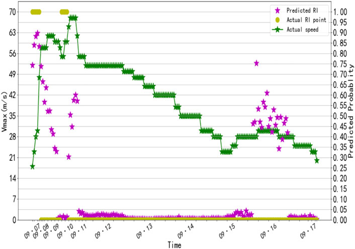
FIGURE 6. Comparison of model predicted abrupt change probability (purple asterisks) and actual abrupt change probability (green dots) of Typhoon Chanthu.
In addition, the test analysis of the independent sample of operational typhoon cloud maps for 2021 showed that the composite accuracy of the sudden change of typhoon intensity estimation in 2021 reached 91.8%, and the test results showed that the AI-based typhoon rapid strengthening trend discrimination technology is better than the traditional subjective intensity forecasting method, and has certain operational application value.
Heat maps are a common visualization tool that aggregate a large amount of data and represent it with progressive color bands, which can visually show the similarities and differences between data. One of the important roles is to show the correlation between different indicators and different samples. As shown in Figure 7, there was a positive correlation between the cloud structure of the typhoon vortex and the wind speed and rapid intensification of the typhoon at the same time, especially the vortex structure near the center of typhoon. When the cloud pattern and its corresponding intensity are subjected to LSTM, there is high confidence in the ability to discriminate the RI trend in the next phase.
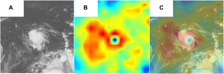
FIGURE 7. (A) The FY-4A satellite cloud of Typhoon 2114 at 09–07 18:00; (B) is the heat map obtained by passing through the ResNet model and convolving the last layer of the ResNet model; (C) is obtained by superimposing (A) and (B) together.
Figure 8 shows the Flowchart of AI-based typhoon monitoring and forecasting system. The integrated AI-based TC monitoring and forecasting system starts from the original satellite data, crops the disc map into an 1800*1800 area image according to the area to be monitored, and then uses the 400 × 400 final image output by the typhoon vortex model, combined with an end-to-end visualized intelligent typhoon intensity fixing model, and fuses the strategies according to the typhoon intensity trend cycle and typhoon intensity abrupt change detection, and finally outputs the typhoon intensity abrupt change trend discrimination results to achieve automated intelligent identification and positioning of intensity fixing and intensity trend discrimination, with the final product for further analysis and utilization by forecasters.
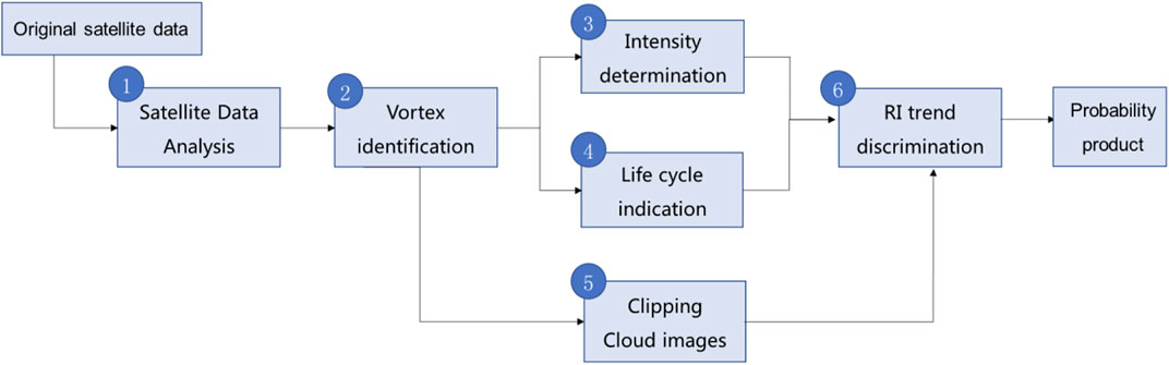
FIGURE 8. Flowchart of AI-based typhoon monitoring and forecasting system.
Figures 9A,B shows the full disk grayscale and 1800*1800 (range 70–160°E, 20°S–70°N) projection maps of the FY-4A satellite cloud map through 7 September 2021 at 12 UTC, respectively. The two typhoon vortices were first identified with a lower confidence threshold (0.2), and then identified with a higher confidence threshold of 0.7, and the secondary de-weighting was performed to further truncate the 400 × 400 final output images, giving confidence probabilities of 0.91 and 0.98, respectively (see Figure 9B), and the identified vortex images of small areas of the typhoon were given separately, along with the estimated intensity of the typhoon. The estimated intensity of Typhoon 2114 “Chanthu” is 28 m/s (Figure 9C), which is slightly weaker than the observed intensity (30 m/s). The estimated intensity of Typhoon Conson is 26 m/s (Figure 9D), which is also slightly stronger than the observed intensity of 28 m/s.
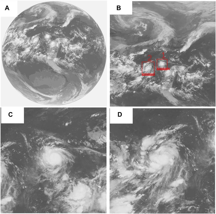
FIGURE 9. Artificial intelligence-based typhoon monitoring and forecasting system (A) FY-4A satellite’s disk map on 7 September 2021 at 12 UTC (B) Range 70–160°E, 20°S–70°N projection area (C) Cropped cloud map of Typhoon 2114 “Chanthu” on September 7 at 12 UTC (D) Cropped cloud map of Typhoon 2113 “Conson” on September 7 at 12 UTC.
From the live intensity, Chanthu experienced a rapid increase in intensity from 30 m/s (Figure 10A) to 58 m/s (Figure 10B) from 0000 UTC on September 7 to 0000 UTC on September 8. As we can see in Figures 11A–D, based on the historical data of the typhoon up to the current moment (7 September 2021, 18 UTC), the spatial and temporal characteristics of the remote sensing cloud maps and the known intensity information series are extracted for Typhoon 2114, and it is predicted that 06UTC on 8 September 2021) the probability of the typhoon showing rapid intensification is 0.84, labeled as a sudden intensity change of 1, and the RI process does occur in reality (wind speed increases by 10 m/s to 58 m/s after 12 h). If it is difficult to distinguish whether the rapid intensification process will occur by manual simply looking at the satellite images, and the model discriminations give a more objective and accurate judgment. This artificial intelligence-based typhoon monitoring and forecasting system has now been carried out on a trial basis in the typhoon operations of the National Meteorological Center.
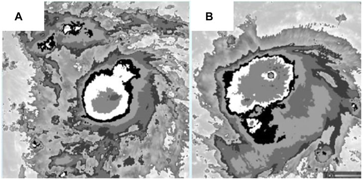
FIGURE 10. Infrared channel satellite cloud image of Typhoon 2114 “Chanthu” (A) 7 September 2021 00UTC (B) September 8, 00UTC.
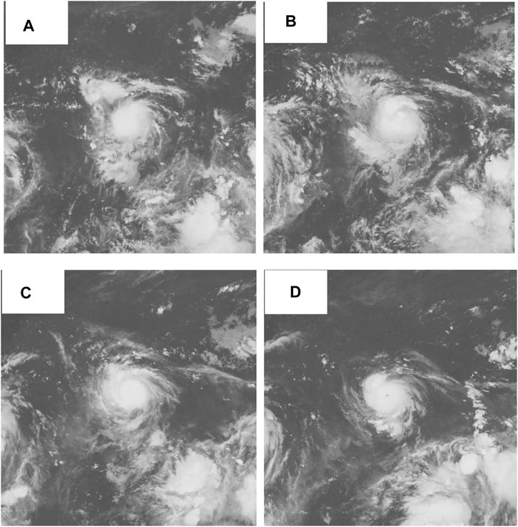
FIGURE 11. Satellite remote sensing cloud maps of Typhoon 2114 at four consecutive times (A) 00UTC on 7 September 2021 (B) 06UTC on September 7 (C) 12UTC on September 7 (D) 18UTC on September 7.
In Table 2, the accuracy index of the model was tested by comprehensive accuracy (Acc), TS score (TS), missing rrate (FNR), and false rate (FPR), where TP represents frequency counted when the actual RI is predicted as RI, TN represents the frequency counted when the actual non-RI is predicted as non-RI, FN represents the frequency counted when the actual RI is predicted as non-RI, and FP represents the frequency counted when the actual non-RI is predicted as RI.
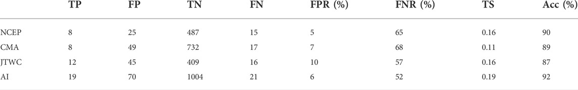
TABLE 2. Comparison table between AI algorithm and different subjective and objective forecasts.
The comprehensive accuracy represents the proportion of the correct prediction of RI among the total samples.
The TS score represents the proportion of the correct prediction of RI after excluding the correct prediction of non-RI.
The missing rate represents the proportion of prediction errors (non-RI) for the instant of RI in reality.
The false rate represents the proportion of prediction errors (RI) for the real non-RI.
According to further statistics comparison in 2021, it can be found comparison between AI and different forecast results. TS of NCEP model is 0.16, TS of JTWC’s forecast is 0.16, TS of CMA’s forecast is 0.11, and TS of our AI algorithm is 0.19. The combined accuracy rate of NCEP model is 90%, that of JTWC’s forecast is 87%, that of CMA’s forecast is 89%, and that of our AI algorithm is 92%. Compared with other different subjective and objective forecasts, our method has high prediction accuracy for actual RI samples. The results also show that the technology based on artificial intelligence is superior to the traditional subjective intensity forecasting method.
Artificial intelligence has shown great potential in typhoon monitoring and forecasting applications. This paper introduced an artificial intelligence-based typhoon monitoring and forecasting system to achieve automated and objective localization, intensity determination and intensity trend discrimination of tropical cyclones. The main research content includes a typhoon vortex identification model based on deep image target detection, an intelligent typhoon intensity determination model based on image classification and retrieval, and a typhoon rapid intensification identification model. The results show that the system is capable of performing the automatic identification, location and intensity determination, and intelligent tracking of tropical cyclones in real time by using high spatial and temporal resolution satellite images.
However, there are still many difficulties and challenges in the application of AI technology in typhoon monitoring and forecasting. In the future, we may deeply explore the various large-scale influencing factors and the typhoon internal forces which affect track and intensity of TCs. Secondly, we may comprehensively use the cloud images of other 13 channels to extract more effective information and feature vectors for typhoon monitoring and forecasting. Moreover, the combination of AI technology and other methods (such as numerical models and ensemble forecasts) will certainly give a great impetus to typhoon monitoring and forecasting, greatly reduce the manual work of forecasters, and improve the effectiveness of disaster prevention and mitigation.
The original contributions presented in the study are included in the article/Supplementary Material, further inquiries can be directed to the corresponding author.
Conceptualization, GZ and XF; methodology, GZ and QQ; analyze data and software, XL and YJ; validation, GZ and JC; formal analysis, GZ; writing original draft preparation, GZ; writing review and editing, JC; project administration: XF; funding acquisition: XF. All authors have read and agreed to the published version of the manuscript.
This study is supported by the National Key Research and Development Program of China under Grant 2017YFC1501604 and The Open Grants of the State Key Laboratory of Severe Weather (Grant Nos. 2022LASW-B09). The authors are thankful to the reviewers for their comments and suggestions on the original manuscript that improved the structures and presentations of the results.
The authors declare that the research was conducted in the absence of any commercial or financial relationships that could be construed as a potential conflict of interest.
All claims expressed in this article are solely those of the authors and do not necessarily represent those of their affiliated organizations, or those of the publisher, the editors and the reviewers. Any product that may be evaluated in this article, or claim that may be made by its manufacturer, is not guaranteed or endorsed by the publisher.
Baik, J. J., and Paek, J. S. (2000). A neural network model for predicting typhoon intensity. J. Meteorological Soc. Jpn. 78, 857–869. doi:10.2151/jmsj1965.78.6_857
Chaudhuri, S., Dutta, D., Goswami, S., and Middey, A. (2013). Intensity forecast of tropical cyclones over North Indian Ocean using multilayer perceptron model: Skill and performance verification. Nat. Hazards 65 (1), 97–113. doi:10.1007/s11069-012-0346-7
Chen, J., and Chavas, D. R. (2020). The transient responses of an axisymmetric tropical cyclone to instantaneous surface roughening and drying. J. Atmos. Sci. 77 (8), 2807–2834. doi:10.1175/JAS-D-19-0320.1
Chen, L. (2010). Tropical meteorological calamities and its research evalution [J]. Meteorol. Mon. 36 (7), 101–110. doi:10.3788/HPLPB20102207.1462
Chen, L., Luo, Z., and Li, Y. (2004). Research advances on tropical cyclone landfall process. Acta. Meteor. Sin. 62, 541–549. doi:10.11676/qxxb2004.055
Chen, R., Wang, X., Zhang, W., Zhu, X., Li, A., and Yang, C. (2019). A hybrid CNN-LSTM model for typhoon formation forecasting. Geoinformatica 23, 375–396. doi:10.1007/s10707-019-00355-0
Cloud, K. A., Reich, B. J., Rozoff, C. M., Alessandrini, S., Lewis, W. E., and Delle Monache, L. (2019). A feed forward neural network based on model output statistics for short-term hurricane intensity prediction. Wea. Forecast. 34, 985–997. doi:10.1175/WAF-D-18-0173.1
Duan, Y., Chen, L., Liang, J., Wang, Y., Wu, L., Cui, X., et al. (2014). Progress in the study of anomalous changes before and after typhoon landfall. J. Meteorology 72 (5), 969–986. doi:10.11676/qxxb2014.085
Duan, Y. H., Fang, J., Cheng, Z. Q., Xu, J., Li, Q. Q., Zhan, R. F., et al. (2020). Advances and trends in tropical cyclone research and forecasting: An overview of the ninth world meteorological organization international workshop on tropical cyclones (IWTC-9). Acta Meteorol. Sin. 78 (3), 537–550. doi:10.11676/qxxb2020.050
Duan, Y., Lian-shou, C. X., and Chuan, Q. (2012). Current status and suggestions of typhoon monitoring and forecasting system in China. Prog. Meteorological Sci. Technol. 14 (9), 4–9. AvaliableAt: https://kns.cnki.net/kcms/detail/detail.aspx?FileName=GCKX201209003&DbName=CJFQ2012.
Emanuel, K. (2005). Increasing destructiveness of tropical cyclones over the past 30 years. Nature 436, 686–688. doi:10.1038/nature03906
Jin, Q., Fan, X., Liu, J., Xue, Z., and Jian, H. (2020). Estimating tropical cyclone intensity in the South China sea using the XGBoost model and FengYun satellite images. Atmosphere 11 (4), 423. doi:10.3390/atmos11040423
Lei, X., Pei-yan, C., Yang, Y., and Yan-zhen, Q. (2009). Typhoon disaster characteristics and objective disaster assessment methods in China. Acta Meteorol. Sin. 67, 875–883. doi:10.3321/j.issn:0577-6619.2009.05.018
Lu, X., Lei, X., and Yu, H. (2014). An objective TC intensity estimation method bas ed on satellite data. J. Appl. Meteor Sci. 25 (1), 52–58.
Matsuoka, D., Nakano, M., Sugiyama, D., and Uchida, S. (2018). Deep learning approach for detecting tropical cyclones and their precursors in the simulation by a cloud-resolving global nonhydrostatic atmospheric model. Prog. Earth Planet Sci. 5, 80. doi:10.1186/s40645-018-0245-y
Pan, B., Xu, X., and Shi, Z. (2019). Tropical cyclone intensity prediction based on recurrent neural networks. Electron. Lett. 55 (7), 413–415. doi:10.1049/el.2018.8178
Pradhan, R., Aygun, R. S., Maskey, M., Ramachandran, R., and Cecil, D. J. (2019). Tropical cyclone intensity estimation using a deep convolutional neural network[J]. IEEE Trans. Image Process. 27 (2), 692–702. doi:10.1109/TIP.2017.2766358
Qian, Q. F., Wang, C., and Xu, Y. J. (2021). A deep learning technique of typhoon intensity estimation [J]. Meteor Mon. 47 (5), 601–660. doi:10.7519/j.issn.10000526.2021.05.008 AvaliableAt: https://kns.cnki.net/kcms/detail/detail.aspx?FileName=QXXX202105008&DbName=CJFQ2021.
Schaffer, J. D., Roebber, P. J., and Evans, C. (2020). Development and evaluation of an evolutionary programming-based tropical cyclone intensity model. Mon. Wea. Rev. 148, 1951–1970. doi:10.1175/MWR-D-19-0346.1
Wang, X., Wang, C., Zhang, L., and Wang, X. (2015). Multidecadal variability of tropical cyclone rapid intensification in the western north pacific. J. Clim. 28 (9), 3806–3820. doi:10.1175/JCLI-D-14-00400.1
Webster, P. J., Holland, G. J., Curry, J. A., and Chang, H.-R. (2005). Changes in tropical cyclone number, duration, and intensity in a warming environment. Science 309, 1844–1846. doi:10.1126/science.1116448
Wimmers, A., Velden, C., and Cossuth, J. H. (2019). Using deep learning to estimate tropical cyclone intensity from satellite passive microwave imagery. Mon. Weather Rev. 147 (6), 2261–2282. doi:10.1175/MWR-D-18-0391.1
Wu, L. G., Zhao, H. K., Wang, C., Cao, J., and Liang, J. (2022). Understanding of the effect of climate change on tropical cyclone intensity: A review. Adv. Atmos. Sci. 39 (2), 205–221. doi:10.1007/s00376-021-1026-x
Wu, Y., Chen, P., and Lei, X. (2017). A preliminary study on the benefit evaluation of the path and intensity prediction of landing tropical cyclones. J. Trop. meteorology 33 (5), 675–682. doi:10.16032/j.issn.1004-4965.2017.05.011
Xu, Y., Zhang, L., and Gao, S. (2010). Current situation and thinking of typhoon forecasting in China. Meteorol. Mon. 36 (007), 43–49. doi:10.3788/HPLPB20102207.1462
Xu, Z., Du, J., Wang, J., Jiang, C., and Ren, Y. (2019). “Satellite image prediction relying on gan and LSTM neural network,” in IEEE International Conference on Communications (ICC), 20-24 May 2019 (Shanghai China: IEEE), 1–6.
Zhang, Q. H., Qing, W., and Lian-shou, C. (2010). Research on the influence of typhoons landing in Chinese Mainland. Chin. Sci. 40 (7), 941–946. doi:10.1016/j.socscimed.2010.05.013
Keywords: deep learning, typhoon vortex identification, determining typhoon location and intensity, rapid intensification, satellite image
Citation: Zhou G, Fang X, Qian Q, Lv X, Cao J and Jiang Y (2022) Application of artificial intelligence technology in typhoon monitoring and forecasting. Front. Earth Sci. 10:974497. doi: 10.3389/feart.2022.974497
Received: 21 June 2022; Accepted: 08 August 2022;
Published: 01 September 2022.
Edited by:
Jingyu Wang, Nanyang Technological University, SingaporeReviewed by:
Chao Chen, Zhejiang Ocean University, ChinaCopyright © 2022 Zhou, Fang, Qian, Lv, Cao and Jiang. This is an open-access article distributed under the terms of the Creative Commons Attribution License (CC BY). The use, distribution or reproduction in other forums is permitted, provided the original author(s) and the copyright owner(s) are credited and that the original publication in this journal is cited, in accordance with accepted academic practice. No use, distribution or reproduction is permitted which does not comply with these terms.
*Correspondence: Xiang Fang, ZmFuZ3hpYW5nQGNtYS5nb3YuY24=
Disclaimer: All claims expressed in this article are solely those of the authors and do not necessarily represent those of their affiliated organizations, or those of the publisher, the editors and the reviewers. Any product that may be evaluated in this article or claim that may be made by its manufacturer is not guaranteed or endorsed by the publisher.
Research integrity at Frontiers
Learn more about the work of our research integrity team to safeguard the quality of each article we publish.