 Yi Wang1
 Wei Du2,3*
 Yuyang Wang1,2Ruiqin Lin2,3Daquan Zhang2,3Fuping Zhao2,3Zhao Sun2,3Yi Chen2,3
 Yang Wang1
- 1Guangdong Provincial Key Laboratory of Geodynamics and Geohazards, School of Earth Sciences and Engineering, Sun Yat-Sen University, Guangzhou, China
- 2Key Laboratory of Unconventional Natural Gas Evaluation and Development in Complex Tectonic Areas, Ministry of Natural Resources, Guiyang, China
- 3Guizhou Engineering Research Institute of Oil and Gas Exploration and Development, Department of Natural Resources of Guizhou Province, Guiyang, China
Regional-scale fault systems are important in adjusting intracontinental deformation. Closure of the Paleo-Tethys, Paleo-Pacific subduction, and India-continent-continent collision have all interacted to shape the Meso-Cenozoic tectonics of South China. The Ziyun-Luodian fault (ZLF) straddles across the Guizhou region in southwestern China. New petrographic and structural studies were conducted to reveal the structural evolution of the ZLF and regional deformation. At least three distinct deformation events are identified within the fault zone: During the Indosinian orogeny, dextral thrusting occurred along the ZLF, accompanied by moderate regional uplift in Guizhou, as evidenced by the Upper Triassic-Lower Jurassic disconformity. The main tectonic framework across Guizhou was established during the Yanshanian orogeny. Driven by the west-dipping Paleo-Pacific subduction (Middle Jurassic-Early Cretaceous), sinistral transpression occurred along the ZLF and NE-to N-S-trending fold belts in central-eastern Guizhou, and the NW-striking folds west of the ZLF were developed in under nearly E-W-directed compression. In the late Cenozoic, the ZLF may have undergone sinistral strike-slip movement, similar to the sinistral Ailaoshan-Red River shear zone. The Ziyun-Luodian fault plays an important role in accommodating the Meso-Cenozoic regional deformation in SW South China.
1 Introduction
The South China Block (SCB) has experienced multiphase tectono-magmatic events, in response to the Phanerozoic convergence, subduction, and collision of tectonic terranes, making the SCB a natural laboratory for understanding intracontinental orogeny (e.g., Li, 2000; Zhou et al., 2006; Zhang and Cai, 2009; Wang et al., 2013; Li et al., 2014). The Mesozoic is a key period for the tectonic evolution of South China, including the Triassic (Indosinian) and Jurassic-Cretaceous (Yanshanian) orogenesis, during which spatially prevalent fault systems and fold belts were developed to accommodate crustal deformation (Wang et al., 2013 and references therein). In the Cenozoic, the India-Eurasia continental collision has driven the growth of the Tibetan Plateau and extended the deformation into the SCB (e.g., Yin & Harrison, 2000; Tapponnier et al., 2001), and existing structural features were tectonically reworked/reactivated in response to its far-field impact (e.g., Li et al., 2005; Shen et al., 2012; Wang et al., 2020). Therefore, the Meso-Cenozoic tectonic evolution is recorded in these large fault and fold systems/belts, which provide insights into the regional deformation patterns and geodynamics.
Comprehensive structural, petrological, geochronological, and geochemical studies have been conducted in the past decades and achieved great advancements in understanding the tectonics and dynamics of the SCB (e.g., Jahn et al., 1990; Charvet et al., 1994; Shu et al., 1998, Shu et al., 2009; Wang et al., 2005, Wang et al., 2013 and references therein). The SCB is connected with the Qinling-Dabie orogenic belt to the north, which were characterized by intense fold-and-thrust belts and HP-UHP metamorphic zone (e.g., Zhang et al., 2013). Its western boundary is the Longmenshan thrust fault, which was formed by the Triassic convergence between the Songpan-Ganze and Yangtze Blocks (e.g., Liu et al., 1995). The SCB is separated from the Indochina Block by the Ailaoshan-Red River shear zone along its southwestern margin (Figure 1; e.g., Zhong, 2000). The Ziyun-Luodian fault (ZLF) is an important tectonic boundary separating the Nanpanjiang basin and Xuefengshan domain in SW China (Zhang et al., 2013). It straddles over several hundreds of kilometers, and is parallel to the well-studied Ailaoshan-Red River shear zone (Figure 1; Wang et al., 2016, Wang et al., 2020). However, little is known regarding its geometry, kinematics, and deformation sequences, especially those in the Meso-Cenozoic.
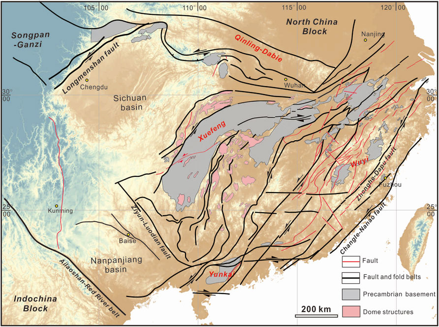
FIGURE 1. Tectonic framework of the South China Block with major fold and fault systems (after Zhang et al., 2013). The SCB was squeezed by the North China Block and Indochina Block, and subsequently affected by the Pacific subduction-accretion.
Here, we report new petrologic and structural observations from field investigations along the ZLF. Based on these data, we examine the geometric features and kinematics of the ZLF and determine its deformation sequence. We also analyze the regional structural features in the Guizhou. Our results contribute to understanding the Meso-Cenozoic tectonic evolution of Guizhou and the role of the ZLF in accommodating regional deformation.
2 Geological setting
The SCB consists of the Yangtze Block in the northwest and the Cathaysia Block in the southeast, which are characterized by different basements (e.g., Wang et al., 2007, Wang et al., 2013; Yu et al., 2010). These two blocks were likely amalgamated before ∼820 Ma, forming the Jiangnan orogenic belt. The ophiolite mélange was situated along the Jiangshan-Shaoxing fault (e.g., Charvet et al., 1996; Shu and Charvet, 1996; Wang et al., 2013). The SCB may have experienced three main regional tectono-thermal events in the early Paleozoic, early Mesozoic, and late Mesozoic, as evidenced by the regional unconformities and Ar-Ar ages of syn-kinematic minerals from major deformation zones (with three age clusters at 440–410 Ma, 240–200 Ma, and 145–95 Ma; Wang et al., 2013 and references therein). Most early Paleozoic structures are tectonically reworked (Wang et al., 2005). Charvet et al. (2010) documented Ordovician flower structure in the Wuyi Mountains, recording the early Paleozoic crustal deformation.
The SCB collided with the North China and Indochina block to the north and south in the Triassic, respectively, establishing the main tectonic framework of the SCB (Wang et al., 2013). The N-S-directed shortening may have occurred in the early Triassic (∼250–225 Ma), and may have resulted in dextral thrusting along a series of the WNW-/W-trending fault and fold systems (Figure 1; Wang et al., 2021). Sinistral transpression may have occurred along the NE-trending fold and fault belts in the SCB interior (ca. 230–190 Ma; Figure 1; Wang et al., 2021). Affected by the west-dipping Paleo-Pacific subduction and subsequent rollback, these NE-trending structures were reactivated and experienced multiple stages of deformation in the late Mesozoic (e.g., Wang et al., 2013, Wang et al., 2021; Li et al., 2014). Furthermore, widespread extensional (half-)grabens with red bed sedimentation, dome structures, and magmatism were developed in the Cretaceous, reflecting regional extension (e.g., Faure et al., 1996; Shu et al., 1998; Zhou et al., 2006; Shu et al., 2009; Chu et al., 2019). Due to the far-field effect of the India-Asia continental convergence, compressional deformation and accelerated regional exhumation were identified across the SCB in the late Oligocene to early Miocene (Wang et al., 2020 and references therein).
The Guizhou region is tectonically located in the SW margin of the Yangtze Block, and is bounded by the Jiangnan orogen to the east, the Sichuan Basin to the north, the Sanjiang orogenic belt to the west, and the Nanpanjiang basin to the southwest (Figure 2). Fold and fault systems are widespread with different kinematic and geometric characteristics, indicating multistage structural superimposition and overprinting (e.g., Li, 2012). The NW-trending ZLF extends across the Yunnan, Guizhou, and Guangxi Provinces in SW China (from Weining to Ziyun for ∼350 km in Guizhou) and joins the Nandan fault in the southeast (Figure 2; Zhang et al., 2013). The ZLF may be originated from a late Paleozoic continental rift, and was reactivated in the Meso-Cenozoic (e.g., Wang and Yin, 2009; Han, 2010; Wu et al., 2012).
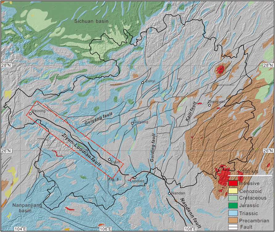
FIGURE 2. Geological map of the Guizhou Province and adjacent regions. The Guizhou Province is tectonically located in the SW margin of the Yangtze Block, adjacent to the Jiangnan orogen to the east, the Sichuan Basin to the north, the Sanjiang orogenic belt to the west, and the Nanpanjiang basin to the southwest. The NW-trending Ziyun-Luodian fault runs across the Yunnan, Guizhou, and Guangxi Provinces in SW China.
3 Stratigraphy
Upper Paleozoic to Mesozoic strata are exposed along the ZLF, albeit being variably deformed by fault movements (Figures 3, 4). Devonian strata are exposed in the southeastern fault segment, including the Huohong, Liujiang, Wuzhishan formations (D1-2h, D3l, and D3C1wz; Figure 4). They are mainly gray-black mudstone intercalated with fine-grained quartz sandstone, thin-medium-bedded chert interlayered with thick limestone. Carboniferous rocks are mainly composed of the Xiangbai (C1x), Jiusi (C1j), Shangsi (C1sh), Weining (CP1w), Nandan (CP1n), Baizuo (Cb), Huanglong (C2h) formations (Figure 4). They are mainly gray-black thin-medium-bedded limestone and dolomite interlayered with mudstone (Cb), black shale with silty mudstone (C1dw), fine-grained sandstone and quartz sandstone (C1x), medium-thick-bedded limestone, argillaceous limestone and dolomite (e.g., the Nandang, Jiusi, and Shangsi formations). The Permian strata in the southeastern fault segment comprise mudstone, carbonaceous shale, limestone, chert, and clastic rocks (e.g., the Sidazhai and Linghao formations).
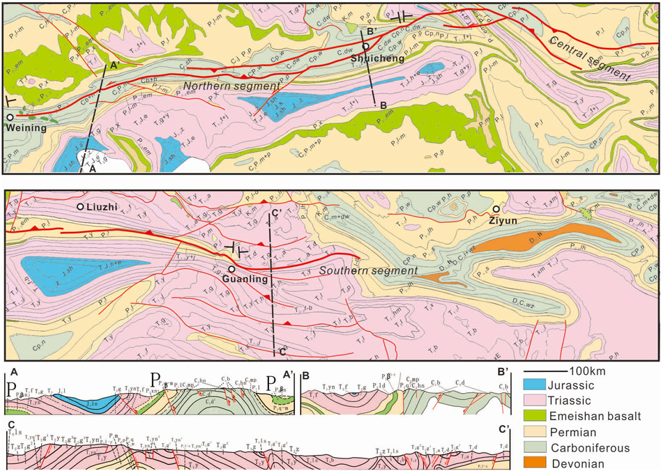
FIGURE 3. Geological map and cross-sections of the Ziyun-Luodian fault and adjacent regions.
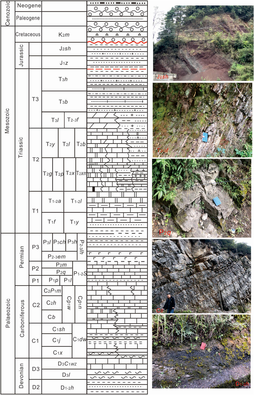
FIGURE 4. Stratigraphic column and typical photos of rock units outcropped along the Ziyun-Luodian fault.
In the northwestern segment, the Permian rocks comprise mainly medium-thick limestone and dolomite intercalated with mudstone (e.g., Qixia and Maokou formations), and Emeishan basalt (Figures 3, 4). Triassic strata (e.g., Luolou, Xuman, Feixianguan, and Guanling formations) are widely distributed along the fault zone, including mainly terrigenous clastic rocks (thin mudstone, silty mudstone, and sandstone) and carbonate rocks (grey dolomite, limestone, and marl). The Jurassic strata are locally distributed along strike (Figure 3). It is mainly composed of fluvial and lacustrine silty mudstone and fine sandstone, with minor lacustrine limestone and marl. They are in disconformity contact with the underlying Triassic strata (Figure 4). The Cretaceous rocks (e.g., Maotai Formation, K2m) do not outcrop along the ZLF, and are locally documented in Guizhou. The Maotai Formation is a set of alluvial red conglomerate, gravel-bearing sandstone and mudstone. The gravel is mainly composed of Carboniferous and Permian limestone (Figure 4).
4 Structural analysis
4.1 Geometry
The NW-striking ZLF can be traced from Weining to the east of Ziyun in the Guizhou region (Figure 2), and is confined by several NE-trending faults at its northeastern end. The fault becomes difficult to trace toward the southeast near Ziyun (Figure 3). Based on the different geometric features along strike, the ZLF can be subdivided into the Weining-Shuicheng, Shuicheng-Guanling, Guanling-Ziyun segments (Figure 3). The northwestern segment (Weining-Shuicheng) strikes 290–320° and consists of several parallel, closely-spaced branches. Most fault branches were developed in the anticlinal core of the Carboniferous limestone (Figure 3). Fault planes dip toward the NE or SW at various angles, forming back-thrust structures. In the middle segment, it branches southeastward into two strands west of Shuicheng. The general strike of the fault zone changes to N20°W, and then turns to N40-60°W west of Liuzhi. Most faults dip toward the NE at high angles. At the intersection with the Guiyang fault, dozens of WNW-trending faults were developed at various scales, which crosscut or confined the ZLF (Figure 2). The ZLF is mainly developed in the anticlinal core of the Permian limestone between Liuzhi and Guanling (Figure 3). In the southeastern segment, several sub-parallel faults were developed southeast of Guanling, mostly dipping toward NE at high angles (Figure 3). Further southeast, although highly fractured bedrock outcrops are identified, we cannot delineate a continuous fault structure.
4.2 Deformation sequence
In order to explore the kinematics and deformation sequence of the ZLF, we present new structural observations along the fault zone. At least three distinct deformation events are identified, dextral thrusting (D1), sinistral transpression (D2), and sinistral shear (D3).
4.2.1 Dextral thrusting (D1)
The deformation fabrics preserved in these upper Paleozoic to Triassic rocks reflect the kinematics from upper-middle structural levels. D1 deformation is best expressed by shortening and transpression structures. Thrust faults were mainly developed within the Carboniferous and Permian strata, e.g., two thrust faults in the Carboniferous limestone (Figure 5A; C1d Datang Formation). The limestone contains medium-thick layer with interbedded mudstone and shows an occurrence of 56°∠60°. A NE-dipping fault damage zone (∼1 m thick) was developed along F1. The limestone wallrock was strongly sheared to form penetrative cleavages dipping toward N55°E at 54°, exhibiting S-C fabrics. Together with asymmetric folds of calcite veins in the fault zone, they all indicate top-to-the-SW thrusting (Figure 5A). In addition, the calcite veins were sheared to form asymmetric boudins in the Y-Z plane, pointing to a dextral strike-slip component. F2 is located >10 m southwest of F1. It was developed along a mudstone layer in the limestone. Penetrative cleavages, asymmetric folds and veins are also identified within the fault zone, indicating the same kinematics. In the northwestern segment, the Emeishan basalt is in fault contact with the overlying Permian Qixia Formation limestone. The fault dips toward the NE at 43–60° (Figure 5B). The Permian limestone and Emeishan basalt are intensely fractured on both sides, and the original bedding is difficult to distinguish. Fault gouge (up to 0.5 m thick) was identified adjacent to the fault plane, and contains clasts of various sizes in a greyish-green rock-powder matrix. NW-plunging slickensides were developed on the fault plane, indicating dextral thrusting of the NE wall (Permian limestone) over the SW wall (Emeishan basalt).
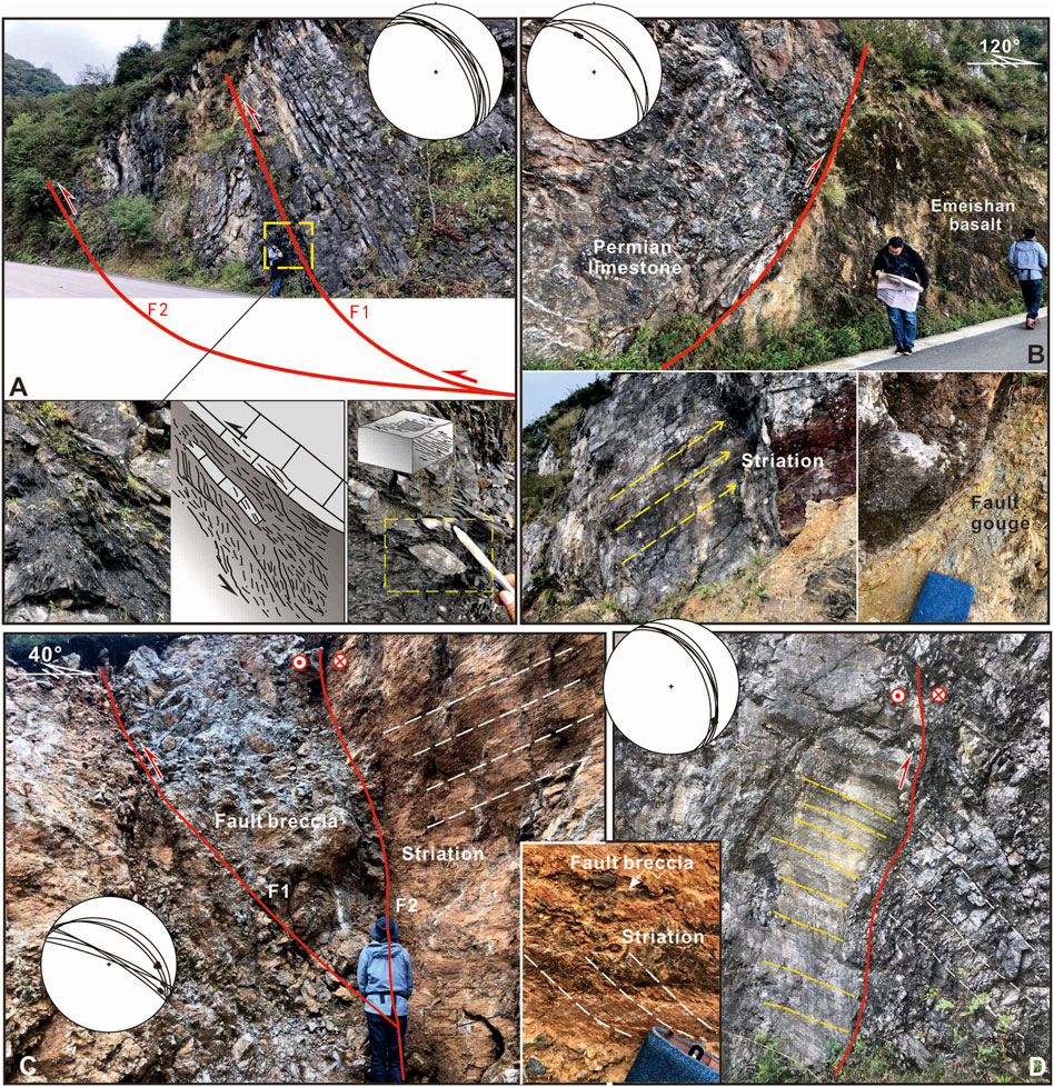
FIGURE 5. Typical deformation associated with dextral thrusting and sinistral transpression. (A) A series of thrust faults developed in the Carboniferous limestone. Deformation fabrics indicate a top-to-the-SW sense of thrusting with a component of dextral strike-slip motion. (B) The Permian limestone was thrust over the Emeishan basalt. (C) A thrust fault developed in the limestone of the Baizuo Formation, which is cross-cut by a steeply-dipping F2. (D) The northeast wall was thrust over the southwest wall in the Triassic dolomite.
4.2.2 Sinistral thrusting (D2)
D2 is also characterized by crustal shortening, but with a clear component of sinistral shearing. For example, a thrust fault was found in the Baizuo Formation limestone, with the NE wall thrust over the SW wall (orientation of F1: 25°∠37°). The bedrock is highly fractured, and fault breccia with (sub)angular limestone clasts is identified in the core of fault zone. The clast alignments indicate thrust faulting. The slickensides are SE-plunging, indicating sinistral shearing. It is worth noting that F1 is cut by the steeply-dipping F2 which strikes N70°W. Sub-horizontal striations and steps are observed on the F2 plane, indicating later sinistral shearing. The former SE-plunging striations are also tectonically reworked (Figure 5C). A sinistral thrust fault is identified in the Permian Qixia Formation. The fault plane is steeply ENE-dipping, and the wallrocks are highly fractured. SE-plunging striations indicate sinistral thrusting of the ENE wall over the WSW wall (Figure 5D).
4.2.3 Sinistral strike-slip faulting (D3)
D3 deformation formed penetrative and steeply-dipping planar fabrics, sub-horizontal striations, and linear geomorphic features. For example, in the central fault segment, Permian and Triassic strata are sinistrally displaced 6–7 km along two NW-trending fault branches (Figure 6A). A linear valley and prominent fault cliffs were developed along strike (Figure 6B). Penetrative fault cleavages were formed in a ∼10 m-wide cataclastic zone (Figure 6C). Sub-horizontal fault striations and steps indicate sinistral strike-slip movement (Figure 6D). In the northern fault segment, a linear valley is identified on the satellite and DEM images, which strikes WNW. A fault zone was found to develop in the Carboniferous Baizuo Formation limestone (Cb), with an orientation of 47°∠71°. The main fault plane strikes N30°W and dips steeply to the NE (Figure 7A). The fault core zone consists of fault gouge and partially-cohesive breccia. The fault gouge is 10–20 cm thick and weakly foliated. The breccia flanking the fault gouge is mainly composed of angular to subangular clasts. The sub-horizontal striations and steps are observed, indicating sinistral strike-slip faulting (Figure 7A). The cataclastic zone consists of strongly deformed limestone with extensive fractures and cleavages. Adjacent to Weining, the thick Baizuo Formation limestone are gently dipping, and are cut-through by a series of strike-slip faults. Multiple branch faults bifurcate upward, striking N20-30°W and dipping to NE or SW steeply. They also show a component of normal faulting, forming a negative flower structure (Figure 7B).
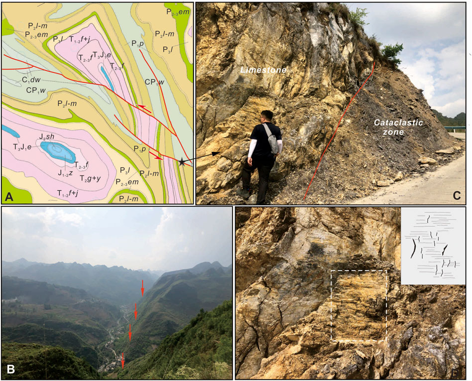
FIGURE 6. Offset geological units and typical deformation fabrics associated with sinistral strike-slip shearing. (A) Permian and Triassic strata are sinistrally displaced by 6–7 km along two NW-striking fault branches. (B) A linear valley and prominent fault cliffs developed along strike. (C) Penetrative fault cleavages formed in the cataclastic zone with a width of ∼10 m. (D) Sub-horizontal striations and steps on the fault plane indicate sinistral strike-slip movement.
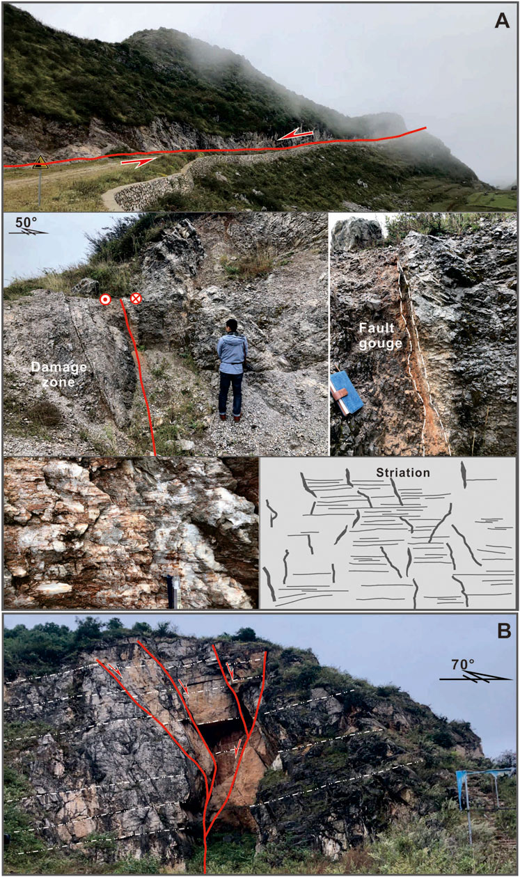
FIGURE 7. Typical deformation fabrics associated with sinistral strike-slip shearing. (A) Steeply dipping fault planes, sub-horizontals striations, and linear valleys indicate sinistral strike-slip movement. (B) A negative flower structure developed in the thick Carboniferous limestone of the Baizuo Formation.
5 Regional deformation patterns
Field investigation and structural analysis of 1:20,000 and 1:50,000 geologic map reveal various types of folds, faults, and strain zones across Guizhou. The most striking features in northeastern Guizhou are a series of Jura-type folds, which exhibit narrow synclines together with open and gentle anticlines (Figure 2). These linear folds mostly strike N-S or NNE (Figure 8). Triassic or Jurassic rocks formed tight synclinal cores (several km wide) and extend for over a hundred kilometers. The limbs dip steeply on both sides. The box-like anticlines are composed of Paleozoic rocks. The strata in the fold core are mostly horizontal or gently dipping. These fold belts are accompanied with numerous sub-parallel thrust faults, which generally dip toward the east (Figure 8). In the southeastern Guizhou, Alpine-type folds were developed in the Precambrian units. These folds mostly strike NE to NNE, with their axial planes being nearly vertical or slightly west-dipping. A series of thrusts also extend NNE parallelly. Linear fold belts are also identified in central Guizhou, which are NNE- or N-S-trending. Along or adjacent to the ZLF, Mesozoic to upper Paleozoic strata formed anticline-syncline pairs, which generally strike NW. The strata on limbs are gently or moderately dipping, and are locally offset by the thrust faults. In addition, dome-shaped folds were developed on both sides of the ZLF. The youngest strata in these folds are Jurassic (Figure 4). Their long axis strikes NW to the west of the ZLF, but mostly strikes NE to the east. The regional fault systems (incl. thrust and normal faults with strike-slip components) are distributed across Guizhou, and displaced or cut the upper Paleozoic to Mesozoic strata. Thrusts are generally NE-to NNE-striking to the east of the ZLF, but change to NW-trending to the southwest, parallel to regional fold belts (Figure 8). The normal faults are developed mainly east of the ZLF, extending parallel to the thrust fault systems and fold bels. This indicates crustal extension after shortening and thickening.
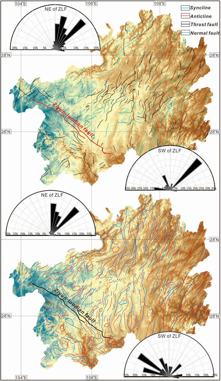
FIGURE 8. Structural pattern of the Guizhou Province.
6 Tectonic evolution
Three distinct episodes of deformation in the Meso-Cenozoic including dextral thrusting, sinistral transpression, and sinistral strike-slip movement have been recognized along the NW-trending Ziyun-Luodian fault, respectively. The deformation sequence of the ZLF is compatible with the regional structural framework. Therefore, in the following part, we integrate existing structural, stratigraphical, and chorological data to constrain the timing of the Meso-Cenozoic tectonic evolution of the ZLF and Guizhou region.
D1 dextral thrusting is inferred to occur in the Triassic, which may be related to a broader tectono-thermal event in South China. The major tectonic framework of South China may have been established in the Indosinian orogeny (e.g., Zhang et al., 2013; Wang et al., 2013 and references therein). Closure of the Paleo-Tethyan and continental collision with the North China Block may have caused the nearly N-S-directed crustal shortening across the SCB (Wang et al., 2021). Accordingly, Wang et al., 2013, Wang et al., 2021 proposed that WNW-/W-striking fault systems (e.g., Hechi-Liucheng, Turong-Jianyang, Nanling, Luoyuan-Mingxi, Xianyou-Zhangping, Fogang-Fengliang, Gaoyao-Huilai and Changjiang-Qionghai) and fold-and-thrust belts (e.g., Shimen-Linxiang, Anhua-Liuyang, Longshan-Liling, Jiuling, Wugongshan, Wudianmei and Guposhan-Huashan) may have developed since the Early Triassic across the SCB, based on petrographic, structural, and 40Ar/39Ar geochronologic evidence. The ZLF may have also been affected by the northward convergence of the Indochina Block in the Triassic. The dextral thrusting along the fault zone may have occurred in response to the N-S-directed compression. In addition, the Triassic and Jurassic strata are in conformable or disconformable contact across the Guizhou region. Therefore, regional uplift and moderate deformation likely occurred during the Indosinian orogeny (Figure 9).
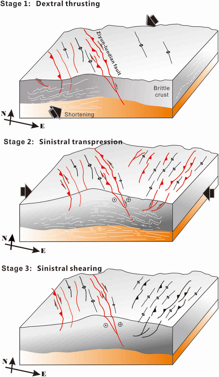
FIGURE 9. Tectonic model of the Ziyun-Luodian fault and the Guizhou Province during the Meso-Cenozoic. At least three stages of deformation including dextral thrusting, sinistral transpression, and sinistral strike-slip movement have been recognized along the ZLF in the Meso-Cenozoic.
D2 sinistral transpression is inferred to occur in the Yanshanian orogeny. NE-/NNE-striking ductile shear zones, thrusts, and fold belts have long been recognized across the SCB, and are attributed to the Paleo-Pacific subduction (e.g., Li and Li, 2007; Zhang and Cai, 2009; Wang et al., 2013, Wang et al., 2021; Li et al., 2014). Older WNW-/W-striking structures were also reactivated. The ZLF may have experienced sinistral transpression under a nearly E-W-directed shortening (Figure 9). The NNE- or N-S-trending Jura-type fold belts and linear anticline-syncline pairs east of the ZLF also indicate ESE-to E-W-directed compression. The youngest strata in the fold belts are the Middle-Upper Jurassic rocks. The Upper Jurassic and Lower Cretaceous strata are mostly absent across Guizhou. The Upper Cretaceous rocks are locally distributed, and are in angular unconformity with the underlying deformed Jurassic and Triassic strata. Therefore, the sinistral transpression along the ZLF and formation of extensive fold belts may have occurred coevally in the Late Jurassic to Early Cretaceous.
It is worth noting that the fold geometry changes spatially across Guizhou. The linear fold belts (Jura- or Alpine type) were mostly developed in the central and eastern Guizhou, and generally change to dome-shaped folds in the western part. The similar deformed strata in these folds suggest that they may have formed at the same stage. However, such geometric variance suggests that the driving force may have originated from the eastern side. Furthermore, the fold long axis is mostly NE-/N-trending and NW-trending in the eastern and western side of the ZLF, respectively (Figure 8). The anticline-syncline pairs are mostly gentle folds in or near the ZLF, except for some locations affected by fault movements. Despite different geometry, we argue that these NW-striking folds were developed coevally with NE-to N-trending folds, since the Middle Jurassic rocks were also involved into the folding. Those observations suggest that the ZLF played an important role in accommodating regional strain during the Yanshanian orogeny.
D3 sinistral strike-slip faulting may have occurred in the late Cenozoic because (Figure 9): 1) subvertical fault planes, sub-horizontal striations, and geomorphic features (such as linear valleys and fault scarps) are present in the fault zone, indicating strike-slip movement. Combined with crosscutting relationship, sinistral shearing represents another deformation episode which is distinct from the early sinistral transpression featured by shortening structures and NW- or SE-plunging striations; 2) to the southwest of the ZLF, several large-scale fault zones were developed sub-parallelly in Yunnan, such as the Ailaoshan-Red River, Chuxiong-Qujiang, Wuliangshan, and Lancang-Genma faults (e.g., Wang et al., 2014, Wang et al., 2022; Li et al., 2020). Published structural analysis and geochronologic data indicate that sinistral strike-slip shearing may have occurred along these faults in the early Oligocene to early Miocene (e.g., Leloup et al., 2001; Liu et al., 2012; Zhang et al., 2014; Wang et al., 2016, Wang et al., 2020, Wang et al., 2022). Based on the similar geometry and kinematics, we infer that the ZLF and the regional NW-trending faults were formed under a uniform tectonic regime to accommodate the SE extrusion of the Indochina block. Therefore, we infer that the sinistral motion along the ZLF likely commenced since the early Oligocene. Interestingly, these NW-striking fault systems mostly experienced kinematic reversal (from sinistral to dextral) since the late Miocene (Wang et al., 2017, Wang et al., 2020, Wang et al., 2022). We cannot determine if dextral motion also occurred along the ZLF due to the limited information, but we deem that possible since modern stress field (derived from oil and gas exploration) adjacent to the fault zone point to N-S-directed maximum horizontal principal stress (Cao et al., 2020).
7 Conclusion
Based on our investigations of the geometry and kinematics of the Ziyun-Luodian fault and regional structural analysis, we conclude that:
(1) At least three Meso-Cenozoic deformation stages, including dextral thrusting, sinistral transpression, and sinistral strike-slip movement occurred along the ZLF.
(2) The Guizhou region may have experienced regional uplift during the Indosinian orogeny. Extensive crustal shortening occurred in a nearly E-W-directed compressional regime in the Late Jurassic and Early Cretaceous, forming Jura-/Alpine-type and dome-shaped folds.
(3) The main tectonic framework in Guizhou was established during the Yanshanian orogeny. The ZLF is a key structure accommodating regional strain and separates different tectonic domains.
(4) The ZLF is characterized by sinistral strike-slip shearing in the late Cenozoic, similar to the NW-trending fault systems in the SE Tibetan Plateau.
Data availability statement
The original contributions presented in the study are included in the article/Supplementary Material, further inquiries can be directed to the corresponding author.
Author contributions
WD and YaW designed the project. YiW, YyW, RL, DZ, FZ, ZS, and YC carried out the field work and collected the samples. YiW, WD, and YaW wrote the manuscript with input of the rest authors.
Funding
This work is supported by the Natural Science Foundation of Guangdong Province (2021A1515011631, 202102020490) and Guizhou Geological Exploration Foundation (208-9912-JBN-L1D7).
Acknowledgments
We sincerely thank Guest Editor Kit Lai for editorial handling and constructive comments and the reviewers for their thorough and critical reviews. All the data used in this study are listed in the references and available in the figures. This work is supported by the Guizhou Geological Exploration Foundation (208–9912-JBN-L1D7) and the Natural Science Foundation of Guangdong Province (2021A1515011631, 202102020490). We appreciate the fruitful discussion with Yang Bing.
Conflict of interest
The authors declare that the research was conducted in the absence of any commercial or financial relationships that could be construed as a potential conflict of interest.
Publisher’s note
All claims expressed in this article are solely those of the authors and do not necessarily represent those of their affiliated organizations, or those of the publisher, the editors and the reviewers. Any product that may be evaluated in this article, or claim that may be made by its manufacturer, is not guaranteed or endorsed by the publisher.
References
Cao, H., Sun, D. S., Yuan, K., Li, A. W., and Z, G. H. (2020). In-situ stress determination of 3 km oil-gas deep hole and analysis of the tectonic stress field in the southern Guizhou. Geol. China 47, 88–98. (in Chinese with English abstract).
Charvet, J., Lapierre, H., and Yu, Y. W. (1994). Geodynamic significance of the Mesozoic volcanism of southeastern China. J. Southeast Asian Earth Sci. 9, 387–396. doi:10.1016/0743-9547(94)90050-7
Charvet, J. L., Shu, S., Faure, M., Choulet, F., Wang, B., Lu, H. F., et al. (2010). Structural development of the lower paleozoic belt of South China: Genesis of an intracontinental orogen. J. Asian Earth Sci. 39 (4), 309–330. doi:10.1016/j.jseaes.2010.03.006
Charvet, J. L., Shu, S., Shi, Y. S., Guo, L. Z., and Faure, M. (1996). The building of South China: Collision of yangzi and Cathaysia blocks, problems and tentative answers. J. Southeast Asian Earth Sci. 13 (3–5), 223–235. doi:10.1016/0743-9547(96)00029-3
Chu, Y., Lin, W., Faure, M., Xue, Z. H., Ji, W. B., and Feng, Z. T. (2019). Cretaceous episodic extension in the south China block, east asia: Evidence from the yuechengling massif of central south China. Tectonics 38, 3675–3702. doi:10.1029/2019tc005516
Faure, M., Sun, Y., Shu, L., Monie', P., and Charvet, J. (1996). Extensional tectonics within a subduction-type orogen: The case study of the wugongshan dome (jiangxi province, southeastern China). Tectonophysics 263, 77–106. doi:10.1016/s0040-1951(97)81487-4
Han, W. (2010). The tectonic evolution and geological significance of the Ziyun-Luodian-Nandan rift zone. Kirkland, WA: Northwest University. (in Chinese with English abstract).
Jahn, B. M., Zhou, X. H., and Li, J. L. (1990). formation and tectonic evolution of southeastern China and taiwan: Isotopic and geochemical constraints. Tectonophysics 183, 145–160. doi:10.1016/0040-1951(90)90413-3
Leloup, P. H., Arnaud, N., Lacassin, R., Kienast, J. R., Harrison, T. M., Trong, P. T. T., et al. (2001). New constraints on the structure, thermochronology, and timing of the Ailao Shan-Red River shear zone, SE Asia. J. Geophys. Res. 106 (B4), 6683–6732. doi:10.1029/2000jb900322
Li, J., Zhang, Y., Dong, S., and Johnston, S. T. (2014). Cretaceous tectonic evolution of South China: A preliminary synthesis. Earth-Science Rev. 134, 98–136. doi:10.1016/j.earscirev.2014.03.008
Li, X. H. (2000). Cretaceous magmatism and lithospheric extension in Southeast China. J. Asian Earth Sci. 18 (3), 293–305. doi:10.1016/s1367-9120(99)00060-7
Li, X. (2012). Mesozoic structural deformation characteristics and superposition pattern in Southwest Guizhou, China. Urban: China University of Geosciences. (in Chinese with English abstract).
Li, X. M., Wang, Y. J., Tan, K. X., and Peng, T. P. (2005). Meso-cenozoic uplifting and exhumation on yunkaidashan: Evidence from fission track thermochronology. Chin. Sci. Bull. 50 (9), 903–909. doi:10.1360/04wd0040
Li, Z., Wang, Y., Gan, W., Fang, L., Zhou, R., Seagren, E. G., et al. (2020). Diffuse deformation in the SE Tibetan plateau: New insights from geodetic observations. J. Geophys. Res. Solid Earth 125. doi:10.1029/2020jb019383
Li, Z. X., and Li, X. H. (2007). Formation of the 1300-km-wide intracontinental orogen and postorogenic magmatic province in mesozoic south China: A flat-slab subduction model. Geol. 35, 179–182. doi:10.1130/g23193a.1
Liu, J. L., Tang, Y., Tran, M. D., Cao, S. Y., Zhao, L., Zhang, Z. C., et al. (2012). The nature of the Ailao Shan-Red River (ASRR) shear zone: Constraints from structural, microstructural and fabric analyses of metamorphic rocks from the Diancang Shan, Ailao Shan and Day Nui Con Voi massifs. J. Asian Earth Sci. 47, 231–251. doi:10.1016/j.jseaes.2011.10.020
Liu, S. G., Luo, L. Z., and Dai, S. L. (1995). Dennis, Arne. C.J.L. Wilson. The uplift of the Longmenshan thrust belt and subsidence of the Western Sichuan foreland basin. Acta Geol. Sin. 1995 (03), 205–214. (in Chinese with English abstract).
Shen, C. B., Mei, L. F., Min, K., Jonckheere, R., Ratschbacher, L., Yang, Z., et al. (2012). Multichronometric dating of the huarong granitoids from the middle Yangtze craton: Implications for the tectonic evolution of eastern China. J. Asian Earth Sci. 52, 73–87. doi:10.1016/j.jseaes.2012.02.013
Shu, L. S., and Charvet, J. (1996). Kinematics and geochronology of the proterozoic dongxiang-shexian ductile shear zone: With HP metamorphism and ophiolitic melange (jiangnan region, south China). Tectonophysics 267 (1–4), 291–302. doi:10.1016/s0040-1951(96)00104-7
Shu, L. S., Sun, Y., Wang, D. Z., Faure, M., Monie, P., and Charvet, J. (1998). Mesozoic doming extensional tectonics of Wugongshan, South China. Sci. China Ser. D-Earth. Sci. 41 (6), 601–608. doi:10.1007/bf02878742
Shu, L. S., Zhou, X. M., Deng, P., Wang, B., Jiang, S. Y., Yu, J. H., et al. (2009). Mesozoic tectonic evolution of the southeast China block: New insights from basin analysis. J. Asian Earth Sci. 34 (3), 376–391. doi:10.1016/j.jseaes.2008.06.004
Tapponnier, P., Xu, Z. Q., Roger, F., Meyer, B., Arnaud, N., Wittlinger, G., et al. (2001). Geology: Oblique stepwise rise and growth of the tibet plateau. Science 294 (5547), 1671–1677. doi:10.1126/science.105978
Wang, E. Q., and Yin, J. Y. (2009). Cenozoic multi-stage deformation occurred in southwest Sichuan: Cause for the dismemberment of the proto-Sichuan Basin. J. Northwest Univ. 39 (03), 359–367. (in Chinese with English abstract).
Wang, X. L., Zhou, J. C., Griffin, W. L., Wang, R. C., Qiu, J. S., O’Reilly, S. Y., et al. (2007). Detrital zircon geochronology of precambrian basement sequences in the jiangnan orogen: Dating the assembly of the Yangtze and Cathaysia blocks. Precambrian Res. 159 (1–2), 117–131. doi:10.1016/j.precamres.2007.06.005
Wang, Y. J., Fan, W. M., Zhang, G. W., and Zhang, Y. H. (2013). Phanerozoic tectonics of the south China block, key observations and controversies. Gondwana Res. 23 (4), 1273–1305. doi:10.1016/j.gr.2012.02.019
Wang, Y. J., Wang, Y., Zhang, Y. Z., Cawood, P. A., Qian, X., Gan, C. S., et al. (2021). Triassic two-stage intra-continental orogenesis of the South China Block, driven by Paleotethyan closure and interactions with adjoining blocks. J. Asian Earth Sci. 206, 1367–9120.
Wang, Y. J., Zhang, Y. H., Fan, W. M., and Peng, T. P. (2005). Structural signatures and 40Ar/39Ar geochronology of the indosinian xuefengshan tectonic belt, south China block. J. Struct. Geol. 27 (7), 985–998. doi:10.1016/j.jsg.2005.04.004
Wang, Y., Schoenbohm, L. M., Zhang, B., Granger, D., Zhou, R. J., Zhang, J. J., et al. (2017). Late Cenozoic landscape evolution along the Ailao Shan Shear Zone, SE Tibetan Plateau: Evidence from fluvial longitudinal profiles and cosmogenic erosion rates. Earth Planet. Sci. Lett. 472, 323–333. doi:10.1016/j.epsl.2017.05.030
Wang, Y., Wang, Y. J., Schoenbohm, L. M., Zhang, P. Z., Zhang, B., Sobel, E. R., et al. (2020). Cenozoic exhumation of the Ailaoshan-Red River shear zone: New insights from low-temperature thermochronology. Tectonics 39, 06151. doi:10.1029/2020tc006151
Wang, Y., Wang, Y. J., Zhang, P. Z., Zhang, J. J., Zhang, B., Zeng, J. L., et al. (2022). Cenozoic tectonic evolution of regional fault systems in the SE Tibetan Plateau. Sci. China Earth Sci. 65, 601–623. doi:10.1007/s11430-021-9880-3
Wang, Y., Zhang, B., Hou, J. J., and Xu, X. W. (2014). Structure and tectonic geomorphology of the Qujiang fault at the intersection of the Ailao Shan-Red River fault and the Xianshuihe-Xiaojiang fault system, China. Tectonophysics 634, 156–170. doi:10.1016/j.tecto.2014.07.031
Wang, Y., Zhang, B., Schoenbohm, L. M., Zhang, J., Zhou, R., Hou, J., et al. (2016). Late Cenozoic tectonic evolution of the Ailao Shan-Red River fault (SE Tibet): Implications for kinematic change during plateau growth. Tectonics 35, 1969–1988. doi:10.1002/2016tc004229
Wu, G. Y., Wang, W. F., and Chi, H. X. (2012). Basin evolution and later reformation of marine sediments in southern Guizhou Depression and neighboring areas. J. Palaeogeogr. 14 (04), 507–521. (in Chinese with English abstract).
Yin, A., and Harrison, T. M. (2000). Geologic evolution of the himalayan-Tibetan orogen. Annu. Rev. Earth Planet. Sci. 28 (1), 211–280. doi:10.1146/annurev.earth.28.1.211
Yu, J. H., O’Reilly, S. Y., Wang, L. J., Griffin, W. L., Zhou, M. F., Zhang, M., et al. (2010). Components and episodic growth of precambrian crust in the Cathaysia block, south China: Evidence from U-Pb ages and Hf isotopes of zircons in neoproterozoic sediments. Precambrian Res. 181 (1-4), 97–114. doi:10.1016/j.precamres.2010.05.016
Zhang, B., Zhang, J. J., Liu, J., Wang, Y., Yin, C. Y., Guo, L., et al. (2014). The Xuelongshan high strain zone: Cenozoic structural evolution and implications for fault linkages and deformation along the Ailao Shan-Red River shear zone. J. Struct. Geol. 69, 209–233. doi:10.1016/j.jsg.2014.10.008
Zhang, G. W., Guo, A. L., Wang, Y. J., Li, S. Z., Dong, Y. P., Liu, S. F., et al. (2013). Tectonics of South China continent and its implications. Sci. China Earth Sci. 56, 1804–1828. doi:10.1007/s11430-013-4679-1
Zhang, K. J., and Cai, J. X. (2009). NE–SW-trending hepu-hetai dextral shear zone in southern China: Penetration of the yunkai promontory of South China into Indochina. J. Struct. Geol. 31 (7), 737–748. doi:10.1016/j.jsg.2009.04.012
Zhong, D. L. (2000). Paleotethyan orogenic belts in yunnan and western sichuan. Beijing: Science Press, 230–240.
Keywords: South China, ziyun-luodian fault (ZLF), structural analysis, tectonic evolution, meso-cenozoic
Citation: Wang Y, Du W, Wang Y, Lin R, Zhang D, Zhao F, Sun Z, Chen Y and Wang Y (2022) Meso-cenozoic tectonic evolution of the ziyun-luodian fault in SW China. Front. Earth Sci. 10:970944. doi: 10.3389/feart.2022.970944
Received: 16 June 2022; Accepted: 25 July 2022;
Published: 17 August 2022.
Edited by:
Kit Lai, Fortescue Metals Group, AustraliaReviewed by:
Chao Wang, The University of Hong Kong, Hong Kong, SAR ChinaKai Liu, China University of Geosciences, China
Copyright © 2022 Wang, Du, Wang, Lin, Zhang, Zhao, Sun, Chen and Wang. This is an open-access article distributed under the terms of the Creative Commons Attribution License (CC BY). The use, distribution or reproduction in other forums is permitted, provided the original author(s) and the copyright owner(s) are credited and that the original publication in this journal is cited, in accordance with accepted academic practice. No use, distribution or reproduction is permitted which does not comply with these terms.
*Correspondence: Wei Du, ZHV3ZWlsZXRpYW5AMTI2LmNvbQ==