 Tianxue Lv
 Jianhua Wan3
- 1College of Environmental Science and Engineering, Nankai University, Tianjin, China
- 2Tianjin Key Laboratory for Urban Ecological Environment Restoration and Pollution Prevention, Tianjin, China
- 3Huakan (Tianjin) Eco-City Academy CO., Ltd., Tianjin, China
Carbon dioxide geological storage is one of the important means to mitigate the greenhouse effect and curb global warming. The key to carbon dioxide (CO2) geological storage is to select a suitable storage site. Using the geological analysis method and analytic hierarchy process (AHP)–fuzzy comprehensive evaluation method, combining the qualitative analysis of geological conditions with the quantitative calculation of site parameters, this study determines a site target area suitable for CO2 geological storage in Tianjin. First, the regional crustal stability of Tianjin is discussed, and the characteristics of regional gravity field anomaly, regional crustal thickness, and regional aeromagnetic characteristics are comprehensively analyzed. The site is focused on Banqiao sag, a class ⅳ tectonic unit in Bohai Bay Basin. Second, aiming at the storability, safety, and economy of the site, the expert investigation method is used to construct the target area evaluation index system, including four primary indexes and ten secondary indexes. The weight of each index is determined using the analytic hierarchy process. A two-level fuzzy comprehensive evaluation mathematical model is constructed. The suitability of CO2 geological storage in three sites (site A, site B, and site C) in Banqiao sag is evaluated. The results are as follows: the comprehensive membership of site A, site B, and site C is 0.8629, 0.3926 and 0.1750, respectively. The comprehensive membership of site A is the largest. The evaluation results show that the preferred target area of Tianjin local carbon dioxide geological storage site is located in ‘site A’ near Dazhangtuo fault in Banqiao sag, Huanghua depression, Bohai Bay Basin (with an area of about 5 km2). In this study, a suitable target area is delineated for the local CO2 geological storage site in Tianjin, which can be used as an advantageous location for CO2 geological storage. The conclusion has a positive response to the problem of CO2 emission reduction in Tianjin.
1 Introduction
CO2 and other greenhouse gas emissions are considered to be the main causes of global warming. The Chinese government attaches great importance to and actively responds to it and puts forward the grand goal of ‘strive to reach the peak of CO2 emissions by 2030 and strive to achieve carbon neutrality by 2060’ (Editorial Department of China energy, 2020). To achieve the goal of carbon neutralization, carbon capture, utilization, and storage (CCUS) technology is the final bottom technology after industry, transportation, construction, and other industries reach the maximum emission reduction target (Ahmadi et al., 2020; Buah et al., 2021; Diao Y J et al., 2021; Li et al., 2019; Qi et al., 2013; Lu et al., 2021a; Wei and Peng, 2013; Xu et al., 2021; Zhang et al., 2008; Qin et al., 2020; Vulin et al., 2020).
CO2 geological storage technology (CCS) transforms CO2 into a supercritical state and stores it in underground storage to realize permanent geological storage (Lu et al., 2021b). CO2 geological storage mechanism (Lu et al., 2021a) mainly includes structural and stratigraphic storage mechanism, irreducible water storage mechanism, dissolution storage mechanism, and mineral storage mechanism (Bachu, 2000; Surdam et al., 2013; Sawada et al., 2018). For the deep saline layer dominated by carbonate rock, the storage process is always the result of the simultaneous action of different storage mechanisms. In the initial stage of CO2 injection, the structural storage and dissolution storage mechanisms play a major role (Azin et al., 2015). With the passage of time, the mechanism of bound water storage and mineralized storage has become increasingly prominent (Li et al., 2016; Nguyen et al., 2017; Ringrose, 2018).
With the surge of carbon emissions in recent years, Tianjin municipal government attaches great importance to the vigorous development of carbon dioxide geological storage technology. The primary problem to be solved by CO2 geological storage technology is the optimization of CO2 gas storage sites. According to the literature review, most of the predecessors determined the location of carbon dioxide geological storage from a geological point of view. (Li et al., 2015; Kulizina, 2016; Lu et al., 2021b; Shen et al., 2021). Such a method for determining the storage site is only analyzed from a qualitative point of view, lacking intuitive contrast. Moreover, when the tectonic unit is small, the geological elements are almost unchanged in the tectonic unit with a unified tectonic background. The single use of the geological analysis method for site selection seriously lacks accuracy. In order to solve this problem, a new method is proposed in this study when selecting the geological storage site of carbon dioxide in Tianjin. The method combines regional stability with the scientific decision-making method--AHP–fuzzy comprehensive evaluation method. First, based on the deep geophysical characteristics, the regional gravity field characteristics, regional crustal thickness, and regional aeromagnetic characteristics of Tianjin are investigated. The regional stability of the region is analyzed, and the alternative location is focused on Banqiao sag, a class IV structural unit in the Bohai Bay Basin. Next, three alternative sites are divided in Banqiao depression, and AHP–fuzzy comprehensive evaluation model is introduced to calculate the comprehensive membership of each alternative site and rank them. The site is selected according to the calculation results. The method combines qualitative description and quantitative analysis, selects storage sites more accurately, and provides a new idea for future generations to select carbon dioxide geological storage sites.
2 Regional geological overviews of Tianjin
2.1 Regional tectonic background
In terms of regional structure, Tianjin is located in the middle and north of Jibo fault block depression and the south of Yanshan fault block uplift (Li J J et al., 2021). Under the structural pattern of NWW and NNE, it is generally characterized by east–west zoning and north–south blocking (Wen, 2013; Li, 2019). In the east–west direction, two depressions and one uplift are formed due to the tension of NNE trending faults; that is, three class III structural units are formed from west to east: Jizhong depression, Cangxian uplift, and Huanghua depression (Wen, 2011, 2013) (Table 1). In the north–south direction, secondary bulges and depressions are formed due to the control of NWW trending faults. The structural trend is mostly NNE (Figure 1 and Figure 2). Quaternary active faults are well-developed in the region, mainly revived pre-existing faults and a few new faults. According to the distribution of active faults, faulted basins, and the relationship with strong earthquake activities, Tianjin is divided into two active fault zones (Liu and Liu, 2008; Wang et al., 2012), namely, the northeast Hebei plain fault zone (Wang, 2004) and the northwest Zhangjiakou Bohai fault zone intersecting with it.
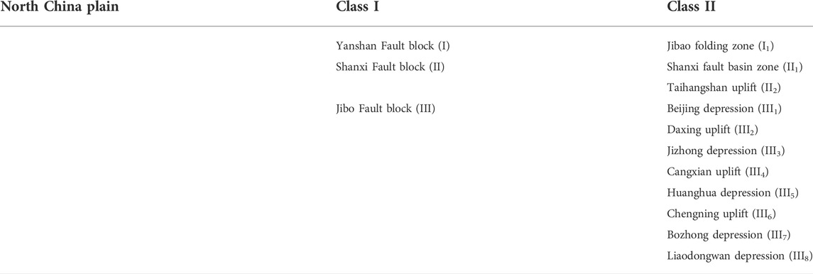
TABLE 1. Regional neotectonic unit division.
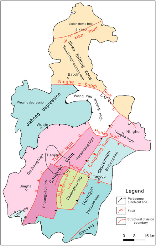
FIGURE 1. Tectonic uniting division map of Tianjin.
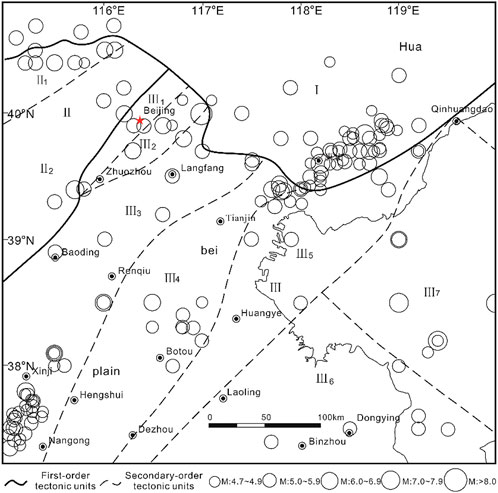
FIGURE 2. Regional neotectonic unit division map.
2.2 Regional neotectonic zoning
Tianjin is backed by Yanshan mountain, with Hebei plain and Bohai Bay in the south-central part. The distribution of regional geomorphic units basically inherited the structural pattern of the Paleogene. Affected by the properties of regional basement media, structural development characteristics, and power sources, the neotectonic movement has zoned in terms of type, amplitude, and mode, which is bound to affect the characteristics of seismic activity. Therefore, neotectonic zoning is the basic basis for the division of seismic tectonic areas and zones. The neotectonic zoning is shown in Table 1.
2.3 The main active fault zones in Tianjin
The regional fault structural belt is mainly composed of NNE-NE and NWW-NW directions, and the two groups of fault belts are conjugate faults to each other, forming the basic fault pattern of the region. Tianjin is located at the intersection of Hebei plain fault zone and Zhangjiakou Bohai fault zone. The NE fault zone that has the greatest impact on Tianjin is Hebei plain fault zone, and the NW fault zone that has the greatest impact on Tianjin is Zhangjiakou Bohai fault zone.
2.3.1 Hebei plain fault zone
Hebei plain fault zone is distributed on the Hebei plain on the east side of Taihang. It is mainly composed of a series of NNE trending dextral shovel normal faults and some NE and N trending faults. The activities of each fault at different times determine the migration law of sedimentation. For example, Jizhong depression is controlled by the NNE trending Baoding Shijiazhuang fault, and Huanghua depression is mainly controlled by Cangdong fault. Most of the fault zones were formed in the early Eocene, and the faults cutting to the crust include Cangdong fault (24), Xiadian fault (15), and Dacheng fault (22). Hebei plain fault zone mainly includes Huangzhuang Gaoliying fault (7), Shunyi Liangxiang fault (8), Xiadian fault (15), Nanyuan TongZhou fault (3), Tangshan fault zone (25), Tianjin north fault (21), Cangdong fault (20), and Nankou piedmont fault (4). Hebei plain fault zone is a very important seismic zone in North China. The earthquake intensity of this seismic zone is generally large. Historical data statistics show that it has experienced 18 earthquakes (including strong aftershocks) with a magnitude of more than 6, including four earthquakes with a magnitude of 7.0–7.9 and one earthquake with a magnitude of 8. Spatially, strong earthquakes with a magnitude of more than 6.0 and most small and medium-sized earthquakes cluster at the intersection of this fault zone and the northwest Zhangjiakou Bohai fault zone.
2.3.2 Zhangjiakou Bohai fault zone
Zhangjiakou Bohai fault zone, also known as Zhangjiakou Penglai fault zone, starts from the west of Zhangjiakou in the west, passes through Huailai, Nankou, Shunyi, Sanhe, and Tianjin in the east, passes through the Bohai Sea, and extends southeast to the North Yellow Sea in the north of Penglai Yantai. It is generally NW distributed, with a total length of about 700 km. The fault zone is formed by the intermittent oblique combination of nearly 20 NW to near east–west trending faults. These faults are generally 40–80 km long, with a large dip angle, and most of them have normal fault translation properties. Tianjin area is mainly affected by Haihe fault in Zhangjiakou Bohai fault zone. The belt mainly includes Jiyunhe fault (20) and Haihe fault 23) in Tianjin.
According to historical and modern instrument records, in Zhangjiakou Bohai fault zone and its adjacent areas, there have been about 26 earthquakes with a magnitude of more than six since AD 294, including seven earthquakes with a magnitude of more than seven and one earthquake with a magnitude of more than 8. Strong earthquakes mostly occurred at the intersection of the NW trending Zhangjiakou Bohai fault zone and the NE trending Hebei plain fault zone. The Sanhe-Pinggu M8 earthquake occurred in 1679. As shown in Figure 3.
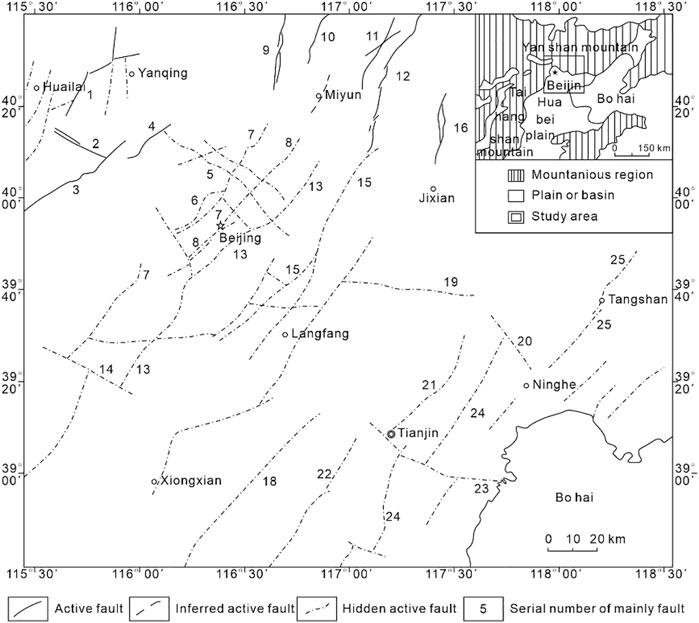
FIGURE 3. Distribution of active faults in Beijing and Tianjin area.
1-Langshan fault; 2-Shizhuang fault; 3-Yanhecheng fault; 4-Nankou fault; 5-Nankou–Sunhe fault; 6-Babaoshan fault; 7-Huangzhuang–Gaoliying fault; 8-Liangxiang–Shunyi fault; 9-Qingshiling fault; 10-Beishicheng fault; 11-Putaoyuan fault; 12-Chenggezhuang fault; 13-Nanyuan–Tongzhou fault; 14-Dongleizi–Laishui fault; 15-Xiadian fault; 16-Huangyaguan fault; 17-Xianghe fault; 18-Wenan fault; 19-Baodi fault; 20-Jiyunhe fault; 21-Tianjinbei fault; 22-Dacheng fault; 23-Haihe fault; 24-Cangdong fault; and 25-Tangshan fault.
3 Optimization of suitable depression for CO2 geological storage based on regional stability
Tectonic stability is the most important part of the evaluation of regional crustal stability and one of the manifestations of the strength of internal dynamic geological processes. In the evaluation of regional crustal stability, we mainly consider fault occurrence, nature, scale, composite relationship, current activity, seismic activity characteristics and relationship with faults, topographic deformation field characteristics, current displacement characteristics of faults, current in-situ stress characteristics, deep structural characteristics, and strain energy density characteristics. Among them, the characteristics of deep structure are particularly important. At present, the analysis and research of deep crustal structure and its activity are mainly based on geophysical exploration methods, using geophysical data for analysis, such as gravity anomaly, aeromagnetic anomaly, earth temperature, earth temperature gradient, and earth heat flow. The results obtained from gravity inversion or electromagnetic sounding or seismic wave velocity measurement can clearly show the crustal thickness.
The characteristics of the geophysical field are the comprehensive reflection of the structural structure, physical property difference, and thermal and stress state of the crust and upper mantle (Qi, 2021). Therefore, studying the characteristics of regional geophysical field can not only help to understand the structural characteristics and material composition distribution characteristics of the crust and upper mantle but also provide a basis for discussing the relationship between seismicity and deep structure.
3.1 Abnormal characteristics of regional gravity field
The variation of thickness and the density of crust and upper mantle are the main reason for the variation of the regional gravity field. Figure 4 is the contour map of Bouguer gravity anomaly in the target area. It can be seen from Figure 4 that the Bouguer gravity zero anomaly zone along the Dezhou Tianjin Baodi line is divided into two anomaly areas, east and west. In the west of the belt, the terrain of Yanshan mountain, Taihang Mountain, and other mountainous areas shows negative anomalies, while in the east of the belt, the terrain of regional subsidence basins, such as Bohai Bay area in the east, shows positive anomalies, reflecting the obvious reverse relationship between gravity field and ground elevation. Zhangjiakou Bohai fault zone is shown as the turning part of gravity anomaly isoline (Yang et al., 2021). It reflects that the fault zone has a certain control over the crustal structure, and it is also the fault zone with the greatest impact on Tianjin. It can be seen from the epicenter distribution of strong earthquakes with M ≥ 6 in Figure 3 that strong earthquakes are mostly distributed in the parts with significant abnormal gradient changes, such as the Sanhe-Pinggu M ≥ 8 earthquake in 1679 and the Tangshan M ≥7.8 earthquake in 1976.
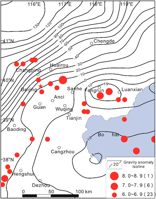
FIGURE 4. Bouguer gravity anomaly map of Tianjin area.
3.2 Regional crustal thickness characteristics
Figure 5 shows the regional crustal thickness. It can be seen from the figure that the uplift and depression are roughly arranged and distributed in the NE-NNE direction. The buried depth of Mohs surface in the slow uplift of North China Plain is generally 28–34 km, the crustal thickness gradually deepens to 40–43 km in Yanshan and Taihang Mountains, and the buried depth of Mohs surface in Cangxian uplift is 35–36 km. In addition, Figure 5 also shows three obvious upper mantle uplifts, namely, the west of Bohai Bay (Mohs surface buried depth of 28 km), the northeast of Baodi (Mohs surface buried depth of 32 km), and the Hejian–Baoding–Langfang area (Mohs surface buried depth of 32 km). Under this uplift background, there are two obvious crustal thickness variation zones in the whole region, namely, the northeast Taihang Mountain variation one and the northwest Zhangjiakou Bohai Sea variation zone.
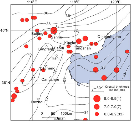
FIGURE 5. Regional crustal thickness map.
3.3 Regional geomagnetic characteristics
Figure 6 shows the geomagnetic field contour of the region with a plane contour map of regional aeromagnetic (ΔT) extended upward for 10 km. The whole region is dominated by positive magnetic anomalies. The intensity of aeromagnetic anomaly in Hebei plain is slightly lower than that in the northern mountainous area. The Beijing–Bohai line shows a low and narrow magnetic band with high intensity and drastic variation, and sporadic negative anomalies appear in some areas. In the south of the belt, the regional magnetic field is mostly northeast, with weak intensity and slow variation.
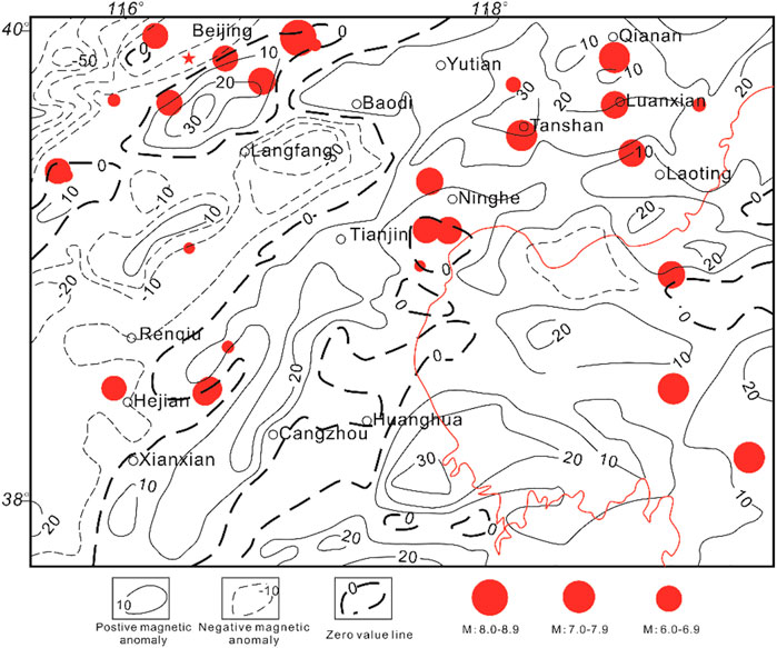
FIGURE 6. Aeromagnetic anomalies of regional aeromagnetic (ΔT) extending 10 km upward.
According to the analysis of Li Jiazheng et al. (Li and Liu, 1989), the distribution relationship between aeromagnetic ΔT characteristics and earthquakes in North China can be summarized as follows:
1)Large area ΔT negative anomaly area, few strong earthquakes occur.
2)Strong earthquakes are mostly distributed at the edge of the massive positive magnetic anomaly region or at the clamping position of two positive magnetic anomalies.
3)At the end of the elongated large area of positive magnetic anomaly, the bifurcation and distortion parts are the favorable parts for strong earthquakes.
3.4 Deep physical characteristics and selection of dominant sag location
Among the three level III tectonic units, Jizhong depression, Cangxian uplift, and Huanghua depression, where Tianjin is located, Huanghua depression (Yang et al., 2020; Li H Z et al., 2021) has been explored for more than 40 years. tIs exploration degree is much higher than the other two tectonic units. Mature exploration studies have confirmed that there is considerable fluid storage space in the area, and the corresponding infrastructure is sound, which can provide a scientific basis for CCUS. Therefore, the geological storage site of carbon dioxide in Tianjin is selected in Huanghua depression.
Huanghua depression (Yang et al., 2020) is structurally complex and can be roughly divided into 10 depressions and 25 fault structural zones. Huanghua depression, where the Tianjin planning area is located, can be divided into three level Ⅳ structures, namely, a positive structure (Ninghe uplift) and three negative structures (Beitang sag, Banqiao sag, and Qikou sag). Because uplift is not conducive to underground fluid accumulation and is much less likely to form an effective trap than sag, Ninghe uplift is not considered in the site selection of this geological storage of carbon dioxide. Qikou sag, with a small land area, is also not suitable. Therefore, Beitang sag and Banqiao sag are the key investigation areas for the selection of carbon dioxide geological storage sites.
Geological safety is the primary factor to realize long-term carbon dioxide sequestration and is also an important factor to be considered in site selection. Many scientific research institutions at home and abroad have carried out scientific research on the geological safety of carbon dioxide long-term sequestration. Some scholars point out (Diao Y et al., 2021) that when evaluating the safety of carbon dioxide geological sequestration, it is necessary to consider the suitability of cap layer, site seismic safety, hydrogeological conditions, and ground site geological conditions.
Ground geological condition is an important factor affecting the optimization of carbon dioxide geological storage site. Technical Requirements for Risk Assessment of Geological Disasters in Construction Land (DZ0245-2004) points out that the areas with a high incidence of geological disasters such as collapse, landslide and debris flow are not suitable for carbon dioxide geological sequestration. Beitang and Banqiao sag, where the probability of geological disasters is generally low, are suitable for the establishment of carbon dioxide gas storage. Beitang and Banqiao sag both belong to the sub-structural units in Huanghua depression. There is little difference in the conditions of cover and hydrogeology between them. Therefore, these two evaluation criteria cannot be used as the main evaluation criteria for selecting site construction.
As stated earlier, this study evaluates Beitang and Banqiao sag from the perspective of site seismic safety and selects one of them as the site for carbon dioxide geological storage in Tianjin. The characteristics of regional geophysical field are closely related to seismic activity, especially strong seismic activity. According to the projection of epicenters of strong earthquakes with magnitudes above six on each graph (Figures 4–6), the location of earthquake occurrence has obvious correlation with geophysical anomalies. Strong earthquakes occur in four major areas: ①The intersection and turning point of gravity and magnetic anomalies in different directions; ② The transition zone of positive and negative anomalies; ③The zone with steeper gravity and magnetic anomaly gradient and significant crustal thickness variation accompanied by deep and large faults; ④The transition zone between uplift and depression of upper mantle.
Compared with Banqiao sag, the gradient variation of gravity and magnetic anomalies in Beitang sag is relatively significant, which is easy to induce strong earthquakes. Additionally, Figure 7 also indicates that the density of active faults in Beitang Sag is higher, while the medium–strong earthquakes in North China almost all occur on the boundary faults of these secondary structures, forming a regular network distribution (Ding and Liu, 1979). In summary, the final location of carbon dioxide geological sequestration is Banqiao depression in Huanghua depression.

FIGURE 7. Three alternative area locations.
4 Based on AHP–fuzzy comprehensive evaluation method to select CO2 storage sites
In the process of site optimization of carbon dioxide geological storage in Tianjin, starting from the regional crustal stability, the abovementioned process uses the geological analysis method to screen the whole city and make a qualitative analysis. Finally, the favorable location of the gas storage is focused in Banqiao depression, a class IV structural unit in the Bohai Bay Basin. At present, there are three sites in Banqiao depression that meet the requirements of establishing carbon dioxide storage, namely, site A, site B, and site C. When making decisions on the three alternative sites, the study introduces the important branch of decision science sequence analysis–analysis hierarchy process, AHP. Combining AHP with a fuzzy comprehensive evaluation method, a set of practical decision-making methods suitable for the selection of carbon dioxide geological storage sites is innovated and explored. In addition, AHP is also a decision-making method involving experts in essence. This research study also invited ten experts and scholars in the field of CO2 geological storage, including seven professors and three managers of geological exploration departments.
4.1 AHP fuzzy comprehensive evaluation
The fuzzy comprehensive evaluation method is a fuzzy mathematical evaluation model. According to the theory of membership, this evaluation method turns qualitative evaluation into quantitative evaluation. It has the characteristics of clear results and strong systematicness. It can better solve fuzzy and difficult to quantify problems and is suitable for solving all kinds of uncertain problems.
One of the prerequisites of the fuzzy comprehensive evaluation method is to determine the weight of each evaluation index. Analytic hierarchy process (AHP) can solve this problem well. Analytic hierarchy process is a simple, flexible and practical multi-criteria decision-making method proposed by Professor T.L.Saaty, an American operations research scientist, in the 1970s. It decomposes a complex problem into constituent factors, forms a hierarchical structure according to the dominant relationship, and then uses the pairwise comparison method to determine the relative importance of the decision-making scheme. The analytic hierarchy process is essentially a decision-making method involving experts, which is especially suitable for decision-making problems in which some factors in the system lack quantitative data.
AHP fuzzy comprehensive evaluation method has good applications in information security risk assessment (Fu and Zhou, 2011), product quality evaluation assessment (Xi and Qin, 2013), and assessing coastal reclamation feasibility (Feng et al., 2014).
Based on the abovementioned facts, this study introduces AHP fuzzy comprehensive evaluation method to scientifically quantify the geological indicators and make scientific decisions to obtain the best storage location when screening the geological storage location of carbon dioxide in Tianjin.
4.2 Analysis of evaluation factors of optimum scheme for carbon dioxide geological storage site
There are many factors that need to be considered in selecting a site to build a carbon dioxide gas storage in Banqiao sag, a level Ⅳ structural unit. Based on previous experience and combined with our own research, four key indicators are selected. These indicators include:
1) Reservoir condition C1: The reservoir is the main body of carbon dioxide geological storage and the storage box of the gas storage, so the quality of the target reservoir is the most important evaluation index for the project. Reservoir conditions can be divided into four sub-indexes, including reservoir porosity (S11), reservoir permeability (S12), reservoir thickness (S13), and reservoir area (S14). Reservoir porosity, reservoir thickness, and reservoir area together determine the carbon dioxide capacity of the selected geological body. Reservoir permeability is essential for gas injection and numerical simulation of underground fluid occurrence in later engineering.
2) Caprock condition C2: Cap layer is an important prerequisite for long-term, stable, and safe geological storage of carbon dioxide. The sealing ability evaluation of caprock is not only affected by its micro-sealing ability but also restricted by the size of its macro-distribution area. Therefore, when evaluating the sealing ability of caprock, both the micro-sealing ability and its macro-development characteristics should be considered. According to the above analysis, the cover condition is decomposed into two sub-indexes: cover permeability (S21) and cover thickness (S22). Generally, the physical property of the caprock is very poor. The greater the physical property difference between the reservoir and caprock, the greater the breakthrough pressure of the fluid in the reservoir to break through the overburden, and the better the sealing property of the caprock. Moreover, cap permeability can better evaluate the sealing degree of upward escape of injected CO2 fluid. From the macroscopic point of view, the development of caprock thickness is often an important index to evaluate the sealing quality. The larger the cover thickness is, the better it is for large-scale CO2 sealing.
3) Trap condition C3: Trap is a geological storage space that can prevent fluid from moving further and accumulating in it. It has a subindex: trap type (S3). Traps are usually composed of three parts, namely, reservoir, cap rock, and barrier, to prevent hydrocarbon accumulation caused by continued migration of oil and gas. The barrier can be the bending deformation of the cap rock itself, such as anticline, or other barriers, such as faults and lithology changes. Therefore, the trap conditions are related to the reservoir and cap rock. Traps can be divided into different types according to the occlusions, such as structural traps, lithologic traps, and hydrodynamic traps, among which lithologic traps are most suitable for carbon dioxide storage.
4) Economic costs C4: The economic costs of CCS mainly consist of three parts: CO2 capture cost and transportation cost and storage cost (Huo, 2014). This article discusses only the economic costs associated with site selection. From the earlier discussion, it can be seen that economic cost is related to buried depth and exploration degree. Density of exploration Wells S41: Obtaining geological data is critical in the process of selecting carbon dioxide geological storage sites. In order to understand the underground geological conditions, geological exploration usually requires a combination of drilling, logging, and 3D seismic and other engineering data with geological personnel’s field survey, which costs a lot to acquire. To carry out CCS work in areas with a high exploration basis, it can not only fully obtain geological data but also make use of existing surface infrastructure, and find suitable sites for gas storage so as to optimize the economic cost to the lowest. The degree of exploration can be characterized by the density of exploration wells. Buried depth S42: Buried depth of CO2 geology must be greater than 800 m. The burial depth of 800 m is the minimum depth for CO2 to reach a supercritical state. The stratum burial depth will affect the economic cost of carbon dioxide gas injection, and the two are interrelated. The distance from carbon dioxide source S43 will directly lead to high transport costs and affect the development degree of carbon dioxide geological storage project. Therefore, it is necessary to choose a suitable location close to the carbon dioxide emission point source as the gas storage site.
In Banqiao depression, there are three alternative areas for this carbon dioxide geological storage site, covering an area of 5 km2, located near Dazhangtuo fault (site A), Banqiao fault (site B), and Changlu fault (site C), respectively. The specific location is shown in Figure 7. Specific index values are shown in Table 2.
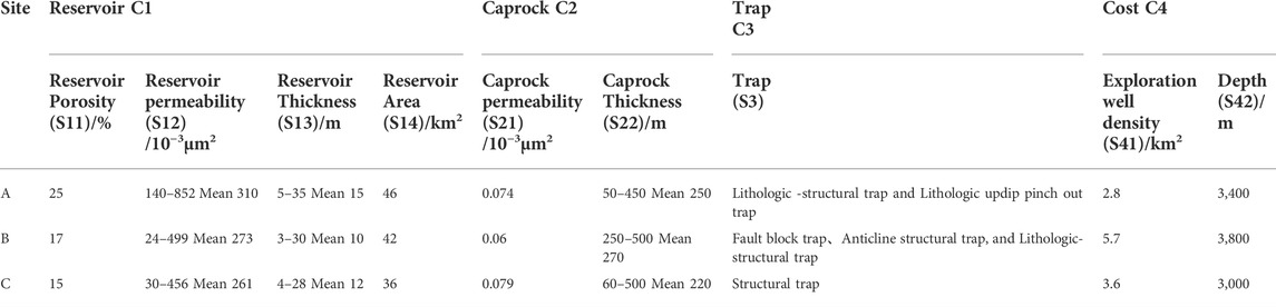
TABLE 2. Alternative location indicators.
4.3 AHP–fuzzy comprehensive evaluation method is used to evaluate the site optimization scheme
4.3.1 Construct AHP hierarchy diagram
According to the optimization of carbon dioxide geological storage site in Tianjin as the goal O of this decision, the objective can be decomposed into four criteria, namely storage condition C1, caking condition C2, trap condition C3, and economic cost C4, by analyzing the influencing factors of the optimization of carbon dioxide geological storage site. The reservoir conditions can be divided into four sub-criteria, namely, reservoir porosity S11, reservoir permeability S12, reservoir thickness S13, and reservoir area S14. The caprock conditions have two indexes: permeability S21 and thickness S22. Trap conditions can be represented by trap type S3. Economic cost can be divided into three sub-indexes, namely, exploration well density S41, buried depth S42, and distance from CO2 source S43. According to the relationship analysis among various factors, the following AHP model is constructed, as shown in Figure 8.
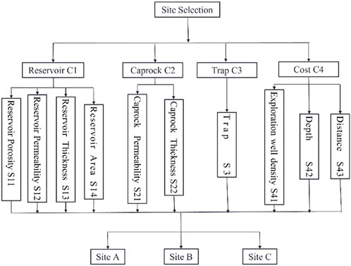
FIGURE 8. AHP evaluation system structure diagram.
4.3.2 Construct judgment matrix and consistency test
Based on the abovementioned hierarchical structure model of AHP, ten experts were invited to hold an expert meeting. The experts give judgment on the relative importance of each element in each level and make a pair-wise comparison to construct judgment matrix A.
In AHP, the integer and reciprocal of 1–9 are used for scale (Table 3) to determine its weight value.
where,
TABLE 3. 1–9 meaning of scale.
It should be pointed out that a chaotic judgment matrix may lead to decision-making errors (Lan 2018), so consistency test is also needed in this step.
The inspection steps are as follows:
1) Consistency index C.I. was calculated as follows:
where
2) The corresponding average random consistency index R.I. table was obtained (as shown in Table 4).

TABLE 4. Average random consistency index.
3) The consistency ratio (C.R) was calculated.
When C.R. is less than 0.1, the consistency of the judgment matrix is considered acceptable; otherwise, the modified judgment matrix is returned. All of the following operations, including conformance checking C.R. values, are performed using the Super Decisions software.
4.3.3 Calculating weight
With the judgment matrix constructed in the above process, the weight of each element corresponding to their respective criteria should be calculated. There are three methods to calculate the weight corresponding to the index in this step, namely, arithmetic average method, geometric average method, and eigenvalue method. This study uses the characteristic root method to calculate the weight value of each geological index of carbon dioxide geological sequestration. Different calculation methods will lead to a slight error in the final weight results. In order to ensure the robustness of the final results, all the weight results obtained by the three methods are calculated and provided at the end of the article. It can be seen that the three weight results are the same.
The following is a brief introduction to the use of the eigenvalue method weight:
W=(w1, … ,wn)T is the weight (ranking) vector obtained by the h-order judgment matrix. When A is the consistency matrix, it is calculated as follows:
The rank of the matrix is 1, satisfying
Here, n is the maximum eigenvalue of A, and W is the eigenvector of the maximum eigenvalue of A. Similarly, judgment matrix A is generally inconsistent. When the consistency of A is acceptable, that is, CR is less than 0.1, because it is A positive matrix, the eigenvector corresponding to the maximum eigenvalue λmax, that is, the eigenvector W satisfying Eq. 6, can be used as an approximate sorting vector. Then, the weight value can be obtained by normalization of the eigenvectors obtained.
MATLAB was used to conduct consistency test on five groups of judgment matrices, and the results of maximum eigenvalue λmax and consistency ratio were obtained, as shown in Table 5.
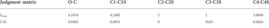
TABLE 5. Maximum eigenvalue and consistency ratio of judgment matrix.
As all the consistency ratios were less than 0.1, the above judgment matrix passed the consistency test, and the eigenvalue method was used to calculate the weight of each indicator, as shown in Table 6.
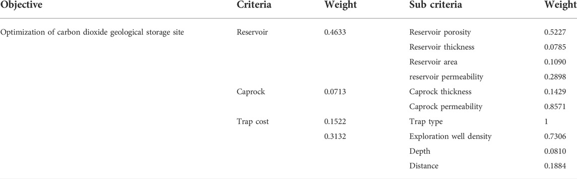
TABLE 6. Weight value of each indicator.
4.4 Fuzzy comprehensive evaluation model
Establish a two-level fuzzy comprehensive evaluation model according to the actual problems in this paper: The establishment of the model mainly includes the following steps:
Step 1. Dividing the factor setIf
Step 2. Determining the schema set
If the weight of
Step 3. Comprehensively evaluating the first-level factor set
Comprehensive evaluation is
Step 4. The corresponding scheme is determined according to the principle of maximum membership degree.It is necessary to determine the membership function when solving by fuzzy mathematics. Generally, there are three methods to determine membership function, namely, fuzzy statistical method, objective scale, and assignment method. It should be pointed out that the determination method of membership function is not unique, and the results of solving different membership function are slightly different. The choice of membership function is reasonable. Fuzzy statistics and assignment methods are used for membership function according to practical problems in this study.
4.5 Application of fuzzy comprehensive evaluation model
According to the specific requirements of the fuzzy comprehensive evaluation model, the following steps are taken:
1) Set of evaluation indicators: four first-level indicators and ten second-level indicators are established. The first-level indicators are reservoir condition, cap condition, trap condition, and economic cost. The secondary indicators are reservoir porosity, reservoir permeability, reservoir area, reservoir thickness, cap permeability, cap thickness, trap type, burial depth, exploration well density, and proximity to carbon dioxide sources.
2) Determining the scheme set.
First, the membership function is determined.
Table 1 indicates that among the 10 second-level indicators, S3 and S43 are qualitative descriptive indicators. When determining their membership degree to the scheme, this study adopts the fuzzy statistics method and asks ten experts and scholars in the industry to score them. The scoring scale is 1–5, and the scores of each indicator are accumulated, and the ratio with the sum is calculated. Next, the membership degree of the index is normalized, and its normalized membership degree is shown in Table 7.
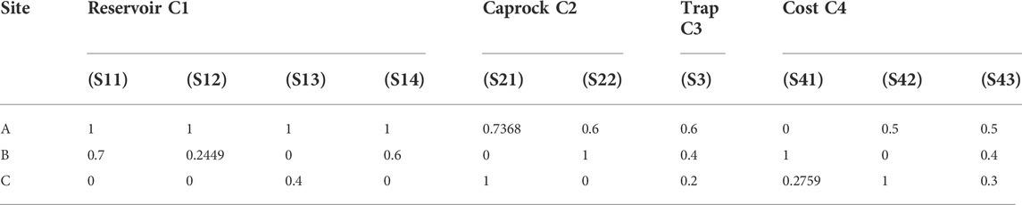
TABLE 7. Membership table of each standard.
3) Establishing fuzzy evaluation matrix.
Except for S3 and S43, the other indicators are quantitative values. These eight indicators can be further divided into extremely large indicators and extremely small indicators; S11, S12, S13, S14, S21, S22, and S41 are extremely large indicators, and S42 is an extremely small indicator. According to the actual situation of each indicator, these eight second-level indicators are treated positively; that is, the greater the membership degree, the indicator is about favorable. Among them, extremely large indicators can be calculated by Formula 9, and extremely small indicators can be calculated by Formula 10:
The final membership degree of each indicator is shown in Table 7.
Reservoir condition evaluation matrix:
Evaluation matrix of cover condition:
Evaluation matrix of trap conditions:
Economic cost evaluation matrix:
(4) First-level fuzzy comprehensive evaluation.
Single factor evaluation of reservoir conditions:
Single factor evaluation of cover condition:
Single factor evaluation of trap conditions:
Single factor evaluation of economic cost:
The evaluation matrix is
(5) Secondary fuzzy comprehensive evaluation.
The comprehensive membership degree of site A, site B, and site C was 0.8629, 0.3926, and 0.1750, respectively, and the maximum membership degree was site A. The results show that the AHP–fuzzy comprehensive evaluation method is used to obtain that site A (Figure 7), located near Dazhangtuo fault in Banqiao sag, Huanghua depression, is the best choice for carbon dioxide geological sequestration in Tianjin.
According to the literature, the oil department has established the Dazhangtuo underground gas storage in Dazhangtuo area, which is the first large-scale natural gas underground storage with an urban seasonal peak shaving function in China (Cui et al., 2003; Wen, 2000; Yang et al., 2003). It also proves that the geological conditions in this area are suitable for gas geological storage. Furthermore, this situation confirms the correctness of the conclusion.
5 Conclusion
An attempt has been made in this study to select the most suitable carbon dioxide geological storage sites within the jurisdiction of Tianjin. Using geological analysis and AHP–fuzzy comprehensive evaluation method to combine qualitative analysis and quantitative calculation so as to select out the best objects from a variety of alternative sites more scientifically and effectively. The conclusions are as follows:
1) Tianjin is located on the northern margin of the North China Penta platform, a class I tectonic unit, which can be divided into two class II tectonic units, Yanshantai fold in the north and North China fault depression in the south. Under the NWW and NNE trending tectonic pattern, the whole structure is characterized by east–west zonation and north–south block. In the east–west direction, two depressions and one uplift were formed due to the extension of the NNE faults; that is, three class III tectonic units were formed from west to east: Jizhong depression, Cangxian uplift, and Huanghua depression. At the same time, Tianjin is mainly divided into two major active fault zones, namely, the northeast Hebei plain fault zone and the intersection of the northwest Zhangjiakou–Bohai fault zone. Considering many factors such as structure, active fault zone and exploration degree, the candidate area is selected in Banqiao sag and Beitang sag of Huanghua depression.
2) Starting from the geological safety of carbon dioxide geological sequestration, this research work studies the suitability of cap layer, site seismic safety, hydrogeological conditions, and ground geological conditions in the two depressions, and finally takes site seismic safety as the main evaluation standard. Based on the deep geophysical characteristics, the characteristics of regional gravity field, regional crustal thickness, and regional aeromagnetic characteristics of Tianjin are analyzed, and their advantages are compared. The following conclusions are drawn: compared with Banqiao sag, the gradient variation of gravity and magnetic anomalies in Beitang sag is significant, which is more likely to induce strong earthquakes. In summary, the final location of carbon dioxide geological sequestration in this study is Banqiao depression in Huanghua depression.
3) AHP–fuzzy comprehensive evaluation method is used to establish a two-level comprehensive evaluation model for the selection of carbon dioxide geological sequestration sites. The target of the preferred site is divided into four selecting criteria, which are reservoir condition, cap condition, trap condition, and economic cost. Reservoir conditions can be decomposed into four sub-criteria: reservoir porosity, reservoir permeability, reservoir thickness, and reservoir area; Caprock conditions have two sub-criteria: caprock permeability and caprock thickness; Traps can be divided into a sub-criterion of trap type; The degree of exploration can be represented by the density and depth of exploration wells. The analytic hierarchy process (AHP) was used to calculate the weights of the ten criteria, and a two-level fuzzy comprehensive evaluation method was established to calculate the three alternative areas in Banqiao depression. According to the calculation results, the comprehensive membership degree of region A near the Dazhangtuo fault is 0.8629, respectively, which is the maximum value, so region A is the best choice for the geological storage of carbon dioxide in Tianjin.
Data availability statement
The original contributions presented in the study are included in the article/Supplementary Material; further inquiries can be directed to the corresponding author.
Author contributions
TL proposed a new method and LY, and JW guided the full study. YZ, LH, and JW helped with the data analysis and figures. TL and YZ wrote the manuscript.
Acknowledgments
The authors thank the class B scientific research project of Tianjin China North Geological Exploration Bureau (HK2021-B13) and the support of Hebei Huakan Resource Environmental Survey Co., Ltd.
Conflict of interest
Authors TL, LY, and YZ are employed by Nankai University and have a cooperative relationship with Huakan (Tianjin) Eco-city Academy Limited Liability Company.
The remaining author declares that the research was conducted in the absence of any commercial or financial relationships that could be construed as a potential conflict of interest.
Publisher’s note
All claims expressed in this article are solely those of the authors and do not necessarily represent those of their affiliated organizations, or those of the publisher, the editors, and the reviewers. Any product that may be evaluated in this article, or claim that may be made by its manufacturer, is not guaranteed or endorsed by the publisher.
References
Ahmadi, P., Chapoy, A., and Burgass, R. (2020). Thermophysical properties of typical CCUS fluids: Experimental and modeling investigation of density. J. Chem. Eng. Data 66 (1), 116–129. doi:10.1021/acs.jced.0c00456
Azin, R., Mehrabi, N., Osfouri, S., and Asgari, M. (2015). Experimental study of CO2–saline aquifer-carbonate rock interaction during CO2 sequestration[J]. Procedia Earth Planet. Sci. 15, 413–420. doi:10.1016/j.proeps.2015.08.023
Bachu, S. (2000). Sequestration of CO2 in geological media: Criteria and approach for site selection in response to climate change[J]. Energy Convers. Manag. 41 (9), 953–970. doi:10.1016/s0196-8904(99)00149-1
Buah, E., Linnanen, L., and Wu, H. (2021). Augmenting the communication and engagement toolkit for CO2 capture and storage projects[J]. Int. J. Greenh. Gas Control 107, 103269. doi:10.1016/j.ijggc.2021.103269
Cui, L. H., Shu, Z. Z., Yang, S. H., Zeng, S. P., and Tang, G. T. (2003). Construction scheme of Dazhangtuo underground gas storage[J]. J. outnal southwest petroleum Inst. (02), 76–79+70.
Diao, Y. J., Ma, X., Li, X. F., Zhang, C. L., and Liu, T. (2021). Evaluation methods of underground space utilization for CO2 geological storage in deep saline aquifers[J]. Geol. Surv. China 8 (04), 87–91.
Diao, Y., Yang, Y., and Li, X. (2021). Management on developing deep underground space for CO2 geological storage[J]. Proc. CSEE 41 (4), 1267–1273.
Ding, G. Y., and Liu, Y. S. (1979). Seismicity and the recent fracturing pattern of the earth crust in China[J]. Acta Geol. Sin. (01), 22–34.
Feng, L., Zhu, X., and Sun, X. (2014). Assessing coastal reclamation suitability based on a fuzzy-AHP comprehensive evaluation framework: A case study of lianyungang, China. Mar. Pollut. Bull. 89 (1-2), 102–111. doi:10.1016/j.marpolbul.2014.10.029
Fu, S., and Zhou, H. (2011). “The information security risk assessment based on AHP and fuzzy comprehensive evaluation[C],” in 2011 IEEE 3rd international conference on communication software and networks (IEEE), 124–128.
Huo, C. L. (2014). Study on the potential evaluation and the storage areas of the carbon dioxide seabed storage in offshore China[D]. (Daliang: Dalian Maritime University.
Kulizina, (2016). Potential analysis of carbon diode geological storage in turpan-hami basin [D]. (Urumqi: Xinjiang University).
Lan, F. (2018). Risk evaluation of software project development based on FISM-ANP一Grey clustering[D]. (Chengdu: University of Electronic Science and technology).
Li, H. Z., Yong, L., Feng, M. J., Li, X. F., Xiu, G, P., Lou, D., et al. (2021). Tight sandstone reservoir formation mechanism of upper paleozoic buried hills in the Huanghua depression, Bohai Bay basin, eastern China[J]. Minerals 11 (12), 1368.
Li J J, J. J., Peng, Y., Zhang, T., Song, L. J., Ni, Z. P., Zhou, J. H., et al. (2021). Division of metallogenic units in North China[J]. North China Geol. 44 (03), 4–24.
Li, J. Z., and Liu, J. K. (1989). A study on the relations between the gravity-magnetic regional amnient field and the faults at the juncture of shanxi, Hebei, shandong and henan provinces[J]. North China Earthq. Sci. (02), 36–49.
Li, Q., Cai, B., Chen, F., Liu, G., and Liu, L. (2019). Review of environmental risk assessment methods for carbon dioxide geological storage[J]. Environ. Eng. 37 (2), 16–24.
Li, S., Li, Y. L., Yu, Y., and Wu, Y. Z. (2015). Research on the effective coefficient of CO2 geological sequestration in salinity aquifer——a case study of jianghan basin[J]. Saf. Environ. Eng. 22 (01), 82–89.
Li, X., Li, Q., Bai, B., Wei, N., and Yuan, W. (2016). The geomechanics of Shenhua carbon dioxide capture and storage (CCS) demonstration project in Ordos Basin, China. J. Rock Mech. Geotechnical Eng. 8 (6), 948–966. doi:10.1016/j.jrmge.2016.07.002
Li, Y. (2019). Mesozoic tectonic deformation and paleostress field the junction of Yanshan and Taihangshan tectonic aroud belt[D]. Beijing): China University of Geosciences.
Liu, K., and Liu, C. C. (2008). Fractal charactics of fault system and their relations with earthquakes in Hebei plain[J]. J. Eng. Geol. (02), 206–210.
Lu, P., Bai, Y., Liu, W. G., Chen, X., Zheng, H. A., Liu, J., et al. (2021a). Optimization of favorable areas for carbon dioxide geological storage in Majiagou Formation in Ordos Basin[J]. Geol. Rev. 67 (03), 816–827.
Lu, P., Hao, Y. Y., Bai, Y., Liu, W. G., Chen, X., Zheng, H., et al. (2021b). Optimal selection of favorable areas for CO2 geological storage in the Majiagou Formation in the Ordos Basin[J]. Int. J. Greenh. Gas Control 109, 103360. doi:10.1016/j.ijggc.2021.103360
Nguyen, M. C., Zhang, Y., Li, J., Li, X., Bai, B., Wu, H., et al. (2017). A geostatistical study in support of CO2 storage in deep saline aquifers of the Shenhua CCS project, Ordos Basin, China[J]. Energy Procedia 114, 5826–5835. doi:10.1016/j.egypro.2017.03.1720
Qi, K. (2021). Meso-Cenozoic lithospheric thermal-rheological structure and deep magmatic-thermal process in the WNCC[D]. (Xi'an: Northwestern University).
Qin, J., Li, Y., and Wu, D. (2020). CCUS global progress and China’s policy suggestions[J]. Petroleum Geol. Recovery Effic. 27 (1), 20–28.
Ringrose, P. S. (2018). The CCS hub in Norway: Some insights from 22 years of saline aquifer storage. Energy Procedia 146, 166–172. doi:10.1016/j.egypro.2018.07.021
Sawada, Y., Tanaka, J., Suzuki, C., Tanase, D., and Tanaka, Y. (2018). Tomakomai CCS demonstration project of Japan, CO2 injection in progress[J]. Energy Procedia 154, 3–8. doi:10.1016/j.egypro.2018.11.002
Shen, H., Fan, B. D., Wang, Q., Zhang, Y. M., Yang, D. X., Guo, H. P., et al. (2021). Petroleum exploration history and enlightenment in Jizhong depression[J]. Xinjiang Pet. Geol. 42 (03), 319–327.
Surdam, R., Jiao, Z., Ganshin, Y., Bentley, R., Garcia-Gonzalez, M., Quillinan, S., et al. (2013). Characterizations of the CCUS attributes of a high-priority CO2 storage site in Wyoming, USA. Energy Procedia 37, 3911–3918. doi:10.1016/j.egypro.2013.06.289
Vulin, D., Muhasilović, L., and Arnaut, M. (2020). Possibilities for CCUS in medium temperature geothermal reservoir. Energy 200, 117549. doi:10.1016/j.energy.2020.117549
Wang, M. G. (2004). The regional crustal stability in Hebei plain and its fuzzy mathematics comprehensive assessment[D]. (Shijiazhuang: Hebei Institute of Technology).
Wang, Y. T., Lv, Y. J., Xie, Z. T., and Zheng, L. F. (2012). Modern activity characteristics of the Hebei plain seismic belt based on seismic activity parameter analysis[J]. Seismol. Geomagnetic Observation Res. 33 (02), 6–14.
Wei, Z., and Peng, L. (2013). Density-driven convection in carbon dioxide geological storage: A review[J]. Hydrogeology Eng. Geol. 40 (2), 101–107.
Wen, X. M. (2013). Tectonic facies and mineralization in Tianjin[J]. Geol. Surv. Res. 36 (02), 123–130.
Xi, X., and Qin, Q. (2013). Product quality evaluation system based on AHP fuzzy comprehensive evaluation[J]. J. Industrial Eng. Manag. 6 (1), 356–366.
Xu, Y., Zhu, L., Chang, D., Tsimplis, M., Greig, C., and Wright, S. (2021). International chains of CO2 capture, utilization and storage (CCUS) in a carbon-neutral world. Elsevier BV.105433.
Yang, R., Zhao, X., Li, H., Zhao, C., Pu, X., Liu, H., et al. (2020). Evolution characteristics of the upper Paleozoic source kitchen and its controlling effects on hydrocarbon accumulation in the Paleozoic petroleum system in Huanghua Depression, Bohai Bay Basin, China. J. Petroleum Sci. Eng. 193, 107415. doi:10.1016/j.petrol.2020.107415
Yang, S. H., He, S. M., Yang, B., Li, B. R., and Zhu, X. L. (2003). The operation proctice and evaluation for Dazhangtuo underground gas stroage[J]. Nat. Gas. Geosci. (05), 425–428.
Yang, X. M., Li, S. B., Han, J., and Lin, X. (2021). Recognition of deep structural characteristics in Tianjin plain area which based on gravity and magnetic anomalies[J]. Geol. Surv. Res. 44 (01), 61–69.
Keywords: Bohai Bay Basin, CO2 geological storage, regional stability, AHP–fuzzy comprehensive evaluation, site selection
Citation: Lv T, Wan J, Zheng Y, He L and Yi L (2022) Optimization of CO2 geological storage sites based on regional stability evaluation—A case study on geological storage in tianjin, china. Front. Earth Sci. 10:955455. doi: 10.3389/feart.2022.955455
Received: 28 May 2022; Accepted: 28 July 2022;
Published: 25 August 2022.
Edited by:
Chen Zhang, Chengdu University of Technology, ChinaReviewed by:
Bamidele Victor Ayodele, University of Technology Petronas, MalaysiaWen Zhiang, China University of Geosciences, China
Copyright © 2022 Lv, Wan, Zheng, He and Yi. This is an open-access article distributed under the terms of the Creative Commons Attribution License (CC BY). The use, distribution or reproduction in other forums is permitted, provided the original author(s) and the copyright owner(s) are credited and that the original publication in this journal is cited, in accordance with accepted academic practice. No use, distribution or reproduction is permitted which does not comply with these terms.
*Correspondence: Lixin Yi, eWlsaXhpbkBuYW5rYWkuZWR1LmNu