 Liang Liu
 Fangfang Liu
 Wei Zhang
 Zhaofeng Xu3
95% of researchers rate our articles as excellent or good
Learn more about the work of our research integrity team to safeguard the quality of each article we publish.
Find out more
ORIGINAL RESEARCH article
Front. Earth Sci. , 25 May 2022
Sec. Geoscience and Society
Volume 10 - 2022 | https://doi.org/10.3389/feart.2022.917520
This article is part of the Research Topic Meta-Scenario Computation for Social-Geographical Sustainability View all 60 articles
The research on the spatial distribution and evolution of ancient settlements from the Neolithic Age to the Bronze Age in Dalian area is of great significance for a profound understanding of the prehistoric human-land relationship in Dalian area. The results showed that: ① The number of settlement sites in Dalian area showed an overall upward trend from the Mid-Neolithic to the Bronze Age. Most sites during the three periods studied were to be found 0–50 m above sea level (asl), with a significant increase in the number of sites located >50 m asl during the Bronze Age. In terms of gradient of slope, all settlements were concentrated on coastal plains or in low-altitude, hilly areas on relatively gentle slopes ranging between 0 and 6°. Settlements from each period faced in all directions, and were mainly located in river valleys or low-altitude mountain valleys with low terrains.② The proximity of ancient settlements to river courses during the Mid Holocene evolved, with Mid and Late Neolithic settlements usually distributed in the range beyond 3 km of the river buffer zone; the distribution of Bronze Age sites was relatively uniform, reflecting an increasing demand for water resources; the density of settlements was clustered between the Mid Neolithic and the Bronze Age, Neolithic sites being both the smallest in number and the most concentrated. ③ The spatiotemporal distribution and evolution of settlements in the Dalian area were influenced by the contemporary climate: the Mid Neolithic climate was warm and humid, and settlements were distributed principally on the various islands near present-day Dalian, and especially Guanglu Island; the Late Neolithic climate became increasingly drier and cooler, stimulating cultural advances and a slight increase in the number of ancient settlements, which gradually developed in the areas in and around present-day Dalian; during the cold and dry Bronze Age, the number of settlements across the Dalian region reached their peak, and it is widely distributed in various areas of Dalian. To a certain extent, this reflected a continuous improvement in the ability of the human population to adapt to the natural environment.
As the core of geography research, human-natural relationship run through each stage of geographical development (Xue et al., 2018). Ancient settlements are places where ancient humans lived, produced and socialized; their spatiotemporal distribution presents a rich archive of geographical and spatial features, all of which were significantly affected by the environment (Guo et al., 2013; Wang et al., 2015). The spatial distribution and evolution of ancient Holocene human settlements have become an important focus within environmental archeological research. Such environmental archeological research (Goude and Fontugne, 2016; Wang et al., 2021; Zhang et al., 2021) covers three main areas (Zhu, 2015; Wu et al., 2021): 1) research into the evolutionary rules governing the spatiotemporal distribution of human sites in the particular study area; 2) research into the archeological stratigraphy of typical sites in the particular study area; and 3) research into the environmental evolution of a particular study area, based on the typical natural sediments found in that area. Information contained within an archeological site can aid the spatiotemporal understanding of such ancient settlements, and can help delineate the roles played by altitude, gradient and river proximity on the cultural development and evolution of these settlements. This can help us comprehend the ancient human-land dynamic and analyze the relationship between the development of settlements and the surrounding environment (Gu and Zhu, 2005). Understanding and interpreting the development and evolution of ancient human cultures, At the same time, it is of great scientific significance to the coordinated development of modern man and land, and that China and the world take the road of sustainable development (Xue and Mario, 2015).
Non-Chinese research into ancient settlements has principally employed GIS for site prediction (Garcia, 2013; 2013; Nsanziyera et al., 2018). Scientists have explored the relationship between settlements, their natural stratigraphy and their climatic environment, etc. (Turney and Brown, 2007; Guo et al., 2018; Huang et al., 2020; Parker et al., 2020). Such research has also focused on quantitative analyses of the range of ancient human activity, using technical approaches (Kidder et al., 2008). Chinese research has mainly focused on Neolithic and Bronze Age sites (An et al., 2006; Deng et al., 2009; Wu et al., 2012b), studying the numbers of ancient settlements from different periods within the Neolithic and Bronze Age, and the sites of such settlements and how they may have been affected by different natural and environmental constraints. GIS spatial analyses have also therefore been widely used in the regional studies of ancient settlements. Chen et al. (2018) established a database of Neolithic cultural sites in the middle reaches of the Yangtze River. The scale, altitude, gradient of slope, distance from river courses and other characteristics of these cultural sites were also systematically analyzed. The number, scale and spatial distribution of these sites constantly expanded during the Neolithic period, with settlements usually found at low altitudes, on gentle terrain and closer to rivers. Yuan (2018) studied the spatial distribution of Lower and Upper Xiajiadian cultural sites in the western Liao River Basin. Bronze Age settlements in the area reached their peak, and were concentrated in the plain and hilly interactive zone between the Liao River and the Daling River Basin. Ren et al. (2021) systematically sorted the distribution of ancient settlements in the Min River Basin using a GIS spatial analysis tool. This analysis indicated that Bronze Age settlements were the most widely distributed, covering the entire watershedAlthough settlements were centered on riversides, they did expand outwards, and there were also sites 15 km away from a river course. It is clear from the above, therefore, that ancient humans made different choices about where to live during different historical periods, often in response to different topographic conditions and geographical locations.
To conclude, Chinese research has principally focused on northwestern China (An et al., 2006;; Chen et al., 2016), its Central Plains (Li et al., 2013; Zhao et al., 2021) and its eastern regions (Wu et al., 2012a; Wu et al., 2012b; Chen et al., 2018). In northeastern China, preliminary studies have been conducted into ancient settlements in northeastern Liaoning Province and the western Liao River Basin (Wang et al., 2016; Zhao et al., 2019). The Dalian area is located in the southern part of the Liaodong Peninsula, where the marine sedimentary environment transitions to a continental sedimentary environment. Research has shown that many cultures and civilizations have arisen in ecological transition zones where there are significant marginal impacts (Wang and Lei, 2002). The Dalian area has, in this regard, nurtured a wealth of Neolithic and Bronze Age cultures, of which the Xiaozhushan and Shuangtuozi cultures are the most representative (Zhang, 2011). However, there have been few studies into the spatial distribution and evolution of Mid Holocene settlements in the Dalian area, meaning that the close relationships between the origins of ancient human civilization, paleogeography and the paleoclimatic environment in this area have not yet been systematized. This paper has therefore taken the Dalian area as its study area. ArcGIS 10.2 software was used to analyze the spatial distribution of Mid Holocene settlements in the Dalian area. this research will help reveal the relationship of Cultural evolution, settlement distribution patterns and environment and climate change.
The Dalian area (Figure 1) is located on the eastern coast of the Eurasian continent, at the southernmost tip of the Liaodong Peninsula, between 120º53′E-123º31′E and 38º43′-40º10′N. It is flanked by the Yellow Sea and the Bohai Sea to the east and west, respectively, and faces the Shandong Peninsula across the sea to its south. The Dalian Sub-Peninsula is wide in the north and narrow in the south, bordered by the sea on both sides, and surrounded by islands. Its landforms are principally composed of low mountains and a hilly peninsula environment. The remnant spines of the Changbai and Qianshan mountain ranges traverse the area along the trend of the Peninsula, forming a ridge terrain with a high center, low east-west flanks, a high northern, and a low southern aspect (Li et al., 2008). The Dalian area lies in a temperate, monsoonal climatic zone, with marine climatic characteristics. Mean annual precipitation (MAP) is ∼610 mm, and the mean annual temperature (MAT) is 10°C (http://data.cma.cn/). The Dalian area has a dense river network; the largest river is the Biliu River, which flows into the Yellow Sea. In addition, there are Yingna River and Sha River into the Yellow Sea and Fuzhou River into the Bohai Sea (Xu, 2019a).
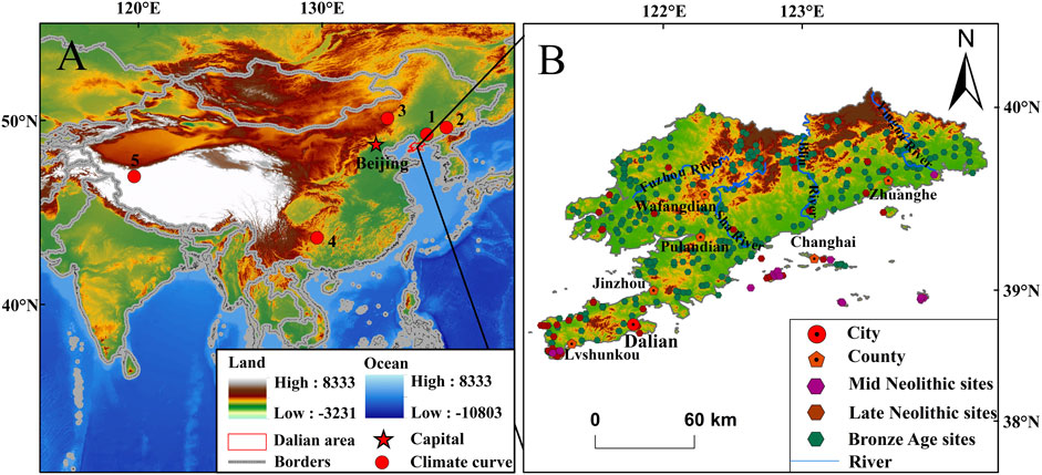
FIGURE 1. Geographical location of the study area, with sites of ancient settlements. (A) The location of Dalian area and climatic curves. (1) The Benxi Nuanhe Cave (Wu et al., 2011; Zhang and Wu, 2012). (2) Sihailongwan (Stebich et al., 2017; Wang et al., 2020). (3) Dali Lake (Wen et al., 2017; Wang et al., 2020). (4) Dongge Cave (Dykoski et al., 2005). (5) Guliya Ice Core (Thompson et al., 1997). (B) Distribution of Sites from the Mid Neolithic to the Bronze Age in Dalian area (Heritage, 2009; Zhang et al., 2016; Xu, 2019a).
The site data presented in this paper were derived from cultural and historical documents, archeological excavation reports from the Dalian area (Zhang et al., 2016; Xu, 2019b), and “The Atlas of Chinese Cultural Relics - Liaoning Volume” (Heritage, 2009). A total of 15 in the Mid Neolithic, 43 in the Late Neolithic and 315 settlements in the Bronze Age were documented and summarized. For the sake of completeness, this study excluded tomb sites with incomplete relevant data, and siters with scattered data (Zhao, 2011), and then sorted out the ancient settlements in the Dalian area as they belong to each cultural period, i.e., the cultural periods that existed during the Mid Neolithic, Late Neolithic and Bronze Age (Table 1). A digital elevation model (DEM) image of the Dalian area, with a horizontal resolution of 30 × 30 m, was extracted from the Geospatial Data Cloud (http://www.gcloud.cn). Using this DEM data, the altitude asl, gradient of slope, aspect and distance from a river course of each ancient site in the study area were extracted. Representative Holocene climatic index data was taken from the NOAA (https://www.ncdc.noaa.gov/paleo-search/) database.

TABLE 1. Cultural sequences of different periods in the study area.
A Voronoi diagram (VD) is a continuous polygon formed by the vertical bisector of the line connecting two adjacent points in the study area. The target area is cut by the plane of the Thiessen polygon, and each center corresponds to a polygon. The distance from any point in the polygon to the center of the area is smaller than the position between this point and the center point of other areas. Since the area of the Thiessen polygon changes with the distribution of the point set, the coefficient of variation (CV) value can be used to measure the relative change in the area of the convex polygon, so as to analyze the spatial distribution of the sample points. The CV is equal to the ratio of the standard deviation of the area of the Thiessen polygon to the mean, and is calculated as:
where R is the standard deviation of the polygon; Si is the area of the ith polygon; S is the mean value of the polygon area; and n is the number of polygons. When the point set is evenly distributed in the space, the area variability of the Thiessen polygon is small, and the CV value is low; when the point set is densely distributed in the space, the Thiessen polygon exhibits a significant variability and a high CV value. Duyckaerts et al. proposed three values: when the CV is 0.29 (<0.33), the spatial point data are uniformly distributed; when the CV is 0.57 (including within the range 0.33–0.64), the spatial point data are characterized by a random distribution; when the CV is 0.92 (>0.64), the spatial point data exhibit a clustered distribution (Xiao, 2019).
The Nearest-Neighbor analysis tool embedded in the ArcGIS software program was used to analyze the cluster characteristics of the sites in the study area using the average nearest neighbor (ANN) index (http://resources.arcgis.com/en/help/main/10.1/index.html). Nearest neighbor analysis was performed on the settlement sites of each cultural period by analyzing the relationship between the distance between the points and the corresponding Thiessen polygons. ANN analysis has three modes of expression: clustered distributions; random distributions; and uniform distributions. The value of the ANN index indicates whether points are clustered (<1), random (= 1), or scattered (>1) in space. It is calculated using the average distance of each point to its nearest neighbor; the formulae are as follows:
where
The distribution of Neolithic to Bronze Age settlements in the Dalian area evinces a certain regularity. This study analyzed 15 sites Mid Neolithic, 43 Late Neolithic and 315 Bronze Age sites in the Bronze Age in the Dalian area. In terms of their altitude (Figure 2; Table 2), from the Mid (Figure 2A) to the Late Neolithic (Figure 2B), to the Bronze Age (Figure 2C), settlements were concentrated in the range of 0–50 m asl, accounting for 86.6%, 72% and 58.1% of the total number of sites from each period, respectively. In the Mid Neolithic period, ∼6.7% of the sites were distributed in low-altitude, hilly areas at altitudes of 50–100 m asl, and >100 m asl.
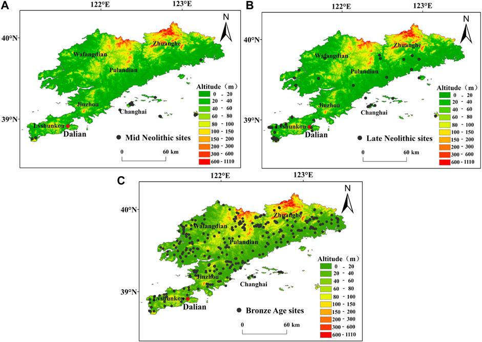
FIGURE 2. Topographic map, with ancient settlement sites in the Dalian area (by period). (A) Mid Neolithic sites. (B) Late Neolithic sites. (C) Bronze Age sites.
TABLE 2. Spatial distribution of, and altitudinal relationship between, ancient settlements in the Dalian area.
When considering gradient of slope (Table 3), Mid Neolithic, Late Neolithic and Bronze Age settlements in the Dalian area were found to be concentrated within the 0–2° and 2–6° ranges, with nine, 31 and 197 sites respectively, accounting for 59.7%, 72.1% and 62.5% of the total number of settlements for each of the three periods. There were also a certain number of sites in the 6∼15° range for each period, accounting for 40%, 23.3% and 30.5% of the total number of settlements for the Mid Neolithic, Late Neolithic and Bronze Age, respectively. When considering any potential relationship between the location of ancient settlements and agriculture, the suitability of the area around each settlement to agricultural development must be taken into account. This is why the gradient of the slope of any cultivated land, as defined by “The Technical Regulations for the Investigation of Land Use Status” (Qiu and Li, 1982), was adopted. Slopes were divided into three grades, based on the ranges of their gradients: slopes of gradient 0–6° were considered of an excellent, 6–15° a good, and >15° a poor, grade. Figure 3A shows that the slopes of Neolithic and Bronze Age sites in the Dalian area were biased towards excellent and good grades.
TABLE 3. Relationship between the spatial distribution and gradients of slope for ancient settlements in the Dalian area.
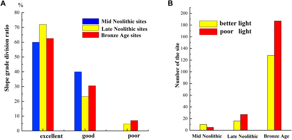
FIGURE 3. (A) Slope hierarchy of ancient settlement sites in the Dalian area, by period. (B) Degree of solar illumination of ancient settlement sites in the Dalian area, by period.
Investigations into the aspects of the Mid Neolithic, Late Neolithic and Bronze Age settlement sites in the Dalian area (Figure 4; Table 4) showed that they faced in all directions, except for three Bronze Age settlements situated on flat land. No Mid Neolithic settlements faced south. During the Mid Neolithic period, sites were mainly distributed on north-, northeast-, east-, southeast-, southwest- and northwest-facing slopes (13 sites, accounting for 86.6% of the total). During the Late Neolithic and the Bronze Age, the distribution of the aspects of sites was generally uniform, inclined usually to the northeast, east, south, southwest and southeast. 28 sites in the Late Neolithic, and 202 sites in the Bronze Age, faced in these directions, accounting for 65.1% and 64.2% of the total sites of the two periods, respectively. 7 and 51 sites faced west, accounting for 16.3% and 16.2% of the total number of Late Neolithic and Bronze Age settlements, respectively. The aspects of settlements in the study area were divided into those which received poor solar illumination (0∼45°, 45∼90°, 270∼315° and 315∼360°) and those with better illumination (90∼270°) (Liu et al., 2021). The number and proportion of archeological remains from each of the three periods distributed on different slopes in the Dalian area were then counted (Figure 3B). During the Mid Neolithic period, more settlements were distributed in areas with good light than in areas with poor light, accounting for 66.7% and 33.3% of the total, respectively. During the Late Neolithic and Bronze Age, more settlements were distributed in areas with poor light.
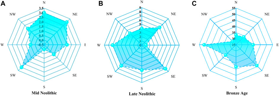
FIGURE 4. Aspects of ancient settlement sites in the Dalian area, by period. (A) Mid Neolithic sites. (B) Late Neolithic sites. (C) Bronze Age sites.
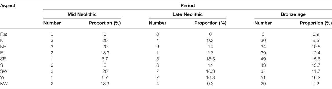
TABLE 4. Relationship between spatial distribution and aspect for ancient settlements in the Dalian area, by period.
Human life is impossible without access to water. Accessibility to river water would therefore have had an impact on the selection of settlement sites by ancient humans. The distance between any settlement and the nearest river course therefore reflects the degree of utilization of water resources by ancient people, as well as the judged safe distance from a river and flood preventative considerations. In this study, a DEM was used to map river systems. Considering that river courses can change significantly over a millennial timeframe, and that the Dalian area’s modern river systems are denser and therefore do not conform to the actual hydrological conditions that would have been present during the three periods studied, the river threshold was set to 10,000 (Chen, 2014). Then, using ArcGIS v10.2 software, a river buffer zone was delineated within a 3 km range from any river system, at intervals of 1 km, and the distance from any settlements to a river course, as well as the distribution ratio of any settlements in the river buffer zone, were counted for each of the three periods.
Figure 5 and Table 5 show the spatial distribution of settlements in the Mid Neolithic, Late Neolithic and Bronze Age in the Dalian area in relation to river systems. Mid Neolithic sites were not distributed within 1 km of rivers (Figure 5A), but mainly (i.e., 86.6%) in a range >3 km beyond water courses. Late Neolithic sites were principally distributed 2–3 km and >3 km away from rivers (Figure 5B) (28% and 41.8%, respectively). Bronze Age settlements were located fairly equally within the ranges of 0–1 km, 1–2 km, 2–3 km, and >3 km from a river course (23.8%, 27%, 21%, and 28.2%, respectively) (Figure 5C). The number of ancient settlements located within 0–3 km of the river system buffer zone in the three periods accounted for 13.4%, 58.2%, and 71.8% of the totals for each period, respectively, indicating that the Neolithic to Bronze Age settlements tended to move closer to river courses.
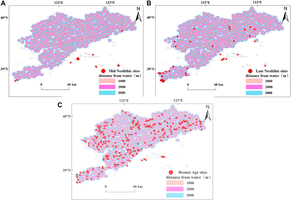
FIGURE 5. Distances between ancient settlements and river courses in the Dalian area, by period. (A) Mid Neolithic sites. (B) Late Neolithic sites. (C) Bronze Age sites.
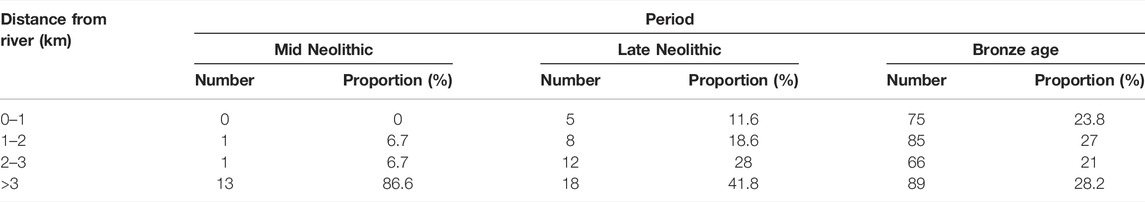
TABLE 5. Relationship between the spatial distribution of ancient settlements in the Dalian area and river buffer zones, by period.
Based on analyses of VDs and CVs, the spatial distributions of ancient settlements in the Dalian area during the three studied periods can be seen to be essentially clustered (Figure 6). ArcGIS v10.2 software was used to generate VDs for the Mid Neolithic (Figure 6A), Late Neolithic (Figure 6B) and Bronze Age (Figure 6C). It can be seen from Figure 6 that although the number of sites in the Mid and Late Neolithic period was small, they were generally clustered close to one another. The number of Bronze Age settlements increased significantly, but their distribution remained relatively clustered. By calculating the polygon area of each cultural period in ArcGIS, and using the formulae outlined in this research, the CV values for the different cultural periods in the Dalian area were obtained. It can be seen from Table 6 that the CV values for the Mid Neolithic, Late Neolithic and Bronze Age were 159.46%, 141.18% and 88.39%, respectively, indicating that settlements from the Mid Neolithic to the Bronze Age were spatially clustered, with Mid Neolithic sites having the highest degree of aggregation.
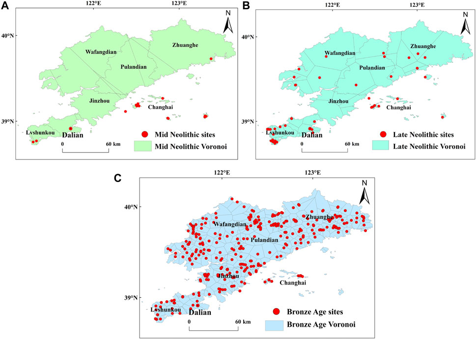
FIGURE 6. Voronoi diagrams for the Dalian area, by period. (A) Mid Neolithic sites. (B) Late Neolithic sites. (C) Bronze Age sites.
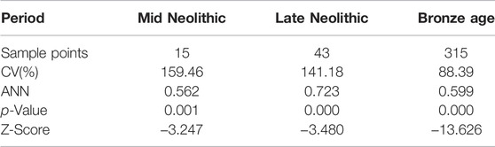
TABLE 6. CV and ANN indices for the Dalian area, by period.
Using analyses of the ANN index for the Dalian area, it was found that the ancient settlements in each period also showed a degree of aggregation. The ANN indices for the Mid Neolithic, Late Neolithic and Bronze Age were 0.562, 0.723 and 0.599 respectively, all <1, indicating aggregation. This was consistent with the VD and CV results, confirming that the distribution of settlements in the Dalian area from the Mid Neolithic to the Bronze Age presents a generally clustered distribution.
Pollen is a surrogate paleoenvironmental indicator that has played an important role in paleovegetation and paleoclimatic reconstructions (Innes et al., 2014; Shen et al., 2017; Zhao et al., 2021a; Zhao et al., 2021b). In recent years, sporopollen analysis has also been widely used in environmental archaeological research (Xu et al., 2002; Peng et al., 2011; Liu et al., 2018), and is therefore of great significance when discussing regional climate change. Due to a lack of complete sporopollen sequences in the Dalian area, the sporopollen archive from the adjacent Liao River Basin area was used (Stebich et al., 2015; Wen et al., 2017; Wang et al., 2020), then combined with stalagmite δ18O records from Benxi Nuanhe Cave (Wu et al., 2011; Zhang and Wu, 2012), Guliya Ice Core δ18O records (Thompson et al., 1997), North Atlantic stained hematite particles (Dong et al., 2015), the stalagmite δ18O records from Dongge Cave (Dykoski et al., 2005) and the Ti content records of Huguangyan Maar Lake (Yancheva et al., 2007), in order to explore the impact of regional climate change on the spatiotemporal evolution of ancient settlements.
According to the sporopollen records from the Liao River Basin and its surrounding areas (Stebich et al., 2015; Wen et al., 2017; Wang et al., 2020) (Figure 7), the broadleaved tree sporopollen content of this temperate zone, when climatic conditions were warm and humid, gradually increased, indicating that the climate became gradually warmer and more humid. At ∼8.4–4.3 ka BP, the broadleaved tree sporopollen content reached its highest Holocene value. Stalagmite δ18O values from the Benxi Nuanhe Cave also show high-frequency fluctuations (Wu et al., 2011; Zhang and Wu, 2012) (Figure 7A). Other climatic records (Dykoski et al., 2005; Yancheva et al., 2007; Yao, 2000; Dong et al., 2015) reflect a gradually intensifying East Asian Summer Monsoon (EASM), during which period precipitation began to increase, reflecting a warmer and more humid climate. This period marked the Holocene Climatic Optimum; the Lower Xiaozhushan (6.7–6.3 ka BP) and Middle Xiaozhushan (6.3–5.3 ka BP) cultures arose within this suitably warm climatic environment. At this time, the number of settlements was relatively small and mainly distributed on various islands, principally Guanglu Island, where the Xiaozhushan Culture settlement was the most representative. The Donggang and Guojiacun ancient settlements were also found in the Lüshunkou area (Xu and Su, 1980; Xu, 2019b), and the Beiwutun site (Xu, 1994) in the Zhuanghe area. However, the nomenclature of these sites has remained controversial. In this study, they were tentatively determined as belonging to the Middle Xiaozhushan Culture (Xu and Jin, 1986; Xu, 1994; Xu, 2019b). All of the above ancient settlements were concentrated in coastal areas at an altitude of 50 m asl, on slopes of gradient <6°, and with good solar illumination. Coastal terraces, estuarine deltas and low-altitude hills provided the principal living environments for ancient peoples. Overall, during this period, human beings were less able to adapt to harsher natural environments, and preferred to live in environments with lower altitudes, gentler slopes and better sunlight.
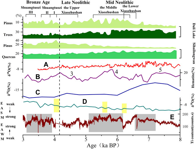
FIGURE 7. Comparison of palynological records from the Liao River Basin (Stebich et al., 2015; Wen et al., 2017; Wang et al., 2020) and other high resolution records. (A) Stalagmite δ18O record, Benxi Nuanhe Cave (Wu et al., 2011; Zhang and Wu, 2012). (B) Hematite-stained grains, North Atlantic (Dong et al., 2015). (C) Guliya Ice Core (Thompson et al., 1997). (D) Stalagmite δ18O record, Dongge Cave (Dykoski et al., 2005). (E) Ti content record, Lake Huguangyan Maar (Yancheva et al., 2007). Note: The yellow bars represent weak East Asian summer Monsoon (EASM) events; the light grey bars represent strong East Asian winter Monsoon events; the figures represent North Atlantic climatic event (Bond event); EASM, East Asian summer monsoon; EAWM, East Asian winter monsoon.
The river buffer zone delineated by ArcGIS indicated that, during the Mid Neolithic period, Lower Xiaozhushan (6.7–6.3 ka BP) and Middle Xiaozhushan (6.3–5.3 ka BP) culture settlements were generally distributed in area beyond 3 km from the river. Because the Xiaozhushan settlements scattered in low-altitude areas on the northwestern and eastern coasts of Guanglu Island were all close to the sea, we judged that there was no shortage of water resources for human survival during this cultural period. Based on the determined 14C ages of the Dagushan peat layer and the Qianyang gray-green silt deposits (Yang and Lin, 1985), the Liaodong Peninsula was at the peak of its climatic transgression at 6.0–5.0 ka BP, and the sea level was 2–4 m higher than now. However, since Guanglu Island is shaped like a turtle’s back and has a raised topography (Li, 2017), we judged that the extent of seawater intrusion into the land during this period was not large, and that any threat to human settlements was therefore limited. The Xiaozhushan settlements are shell mound sites, where a large number of shells have accumulated. Production tools unearthed here have mainly included grinding discs, grinding sticks, and a small number of stone balls and net sinkers. These tools reflect the contemporary fishing and hunting economy (Liu, 2009), with only minor agricultural production.
The degree of aggregation, or cluster, of ancient settlements can reflect the potential communication and interaction between sites. In the Mid Neolithic period, there were not many settlements; Xiaozhushan Culture settlements were mainly located on Guanglu Island, with just a few on the Dalian Sub-Peninsula. Perhaps because of the limitations in the geographical scope of the island and the mainland, these settlements appear to have had little connection with the surrounding land. This was the time of the Holocene Climatic Optimum (8.4–4.3 ka BP), though the island environment also exerted some impact upon the local climate, meaning that ancient humans had to adapt their living environment to the climatic environment; this helps explain why settlements in the Dalian area appear clustered.
The Late Neolithic sporopollen records for the Liao River Basin and its surrounding areas (Wang et al., 2020) show that (Figure 7), at ∼4.3 ka BP, broadleaved trees sporopollen contents, and sporopollens from other trees that like warm and wet conditions, decreased rapidly, and that the climate began to change from being warm and wet, to dry and cool. Globally, a sudden cooling occurred ∼4.3 ka BP; a cold event at ∼4.5 ka BP was recorded in the North Atlantic (Figure 7C) (Dong et al., 2015). The Dongge Cave δ18O stalagmite record (Figure 7B) records a weak EASM at ∼4.2 ka B.P. (Dykoski et al., 2005), and the Huguangyan Maar Lake Ti content archive (Figure 7D) records a weak EAWM at ∼4.5 ka B.P. (Yancheva et al., 2007). Climate change also had an impact on the ancient settlements in the Dalian area. At this time, the Upper Xiaozhushan Culture (4.8–4.1 ka BP) developed. Ancient settlements were initially concentrated in island areas, then gradually expanded to various districts of the mainland Dalian area. These were principally distributed on coastal marine plains at altitudes of <50 m asl, and on slope of gradients <6°, or in low-altitude, hilly areas. The population density also increased. None of these ancient settlements faced south. This would indicate that the population was small at this time, and that human agricultural production was not a major means of food production. The impact of light on agricultural development had not yet been fully realized. Settlements were generally sited on flat terrain, so as to facilitate human travel and water extraction.
The remains of Late Neolithic settlements have been excavated within 1 km of river courses. Although small in number, this perhaps reflects a gradual increase in the human demand for water resources. At this time, most settlements were still located at fixed distances away from river courses. Human beings appear to have been more afraid of flooding than needing greater accessibility to water. The total number of Late Neolithic production tools excavated increases sharply, but felling tools decrease. A large number of pig and dog bones have also been found at the Guojiacun site (Shi, 2008), indicating that, during this period, agriculture and animal husbandry were gradually increasing in importance.
During the Late Neolithic, the degree of aggregation of ancient settlements decreased slightly. In addition to the Xiaozhushan settlement, the number of settlements in the Lüshunkou area of Dalian also increased, and the Santang and the Dapanjia village sites appeared (Liu, 1994; Chen, 1996). This increase in the number of settlements and the expansion in their spatial distribution would indicate that traveling had become gradually easier, hence a relatively lower degree of cluster. This may also be because, at that time, the number of settlements was relatively small, there was less communication with the outside world, and the technical ability to build new settlements was not advanced.
In the Bronze Age, according to the sporopollen archive, arboreal pollens gradually decreased, pine species within broadleaved forest environments increased, and the climatic conditions were significantly drier and colder (Dai et al., 2007). This was a period of regression and stagnation, when Holocene sea levels remained high (Shi, 2006). However, Bronze Age cultures continued to grow and flourish in the Dalian area, mainly including the first, second and third phases of the Shuangtuozi Culture. The number of ancient settlements also increased significantly, and their distribution ranges experienced a period of unprecedented expansion. This might indicate that the climatic deterioration suffered during the Bronze Age did not have a significant impact on the rise of such cultures. This may be explained by population migration, the spread of regional settlements, or the development of agricultural civilization or the rise of social civilization, etc. (Zhang, 2011), promoting a rapid increase in population. At this time, settlements spread from their sporadic spatial distribution in various districts of the Dalian area to a more extensive distribution. Many settlements were located in areas with altitudes of >100 m asl, and slopes of gradients 6–25°, principally low-altitude hills or platforms near piedmont plains or water systems. This may have been to guard against flooding and attacks from wild animals. The ability of ancient humans to adapt their production capabilities and capacity with regard to the natural environment improved. Furthermore, the increase in the number of settlements would suggest that people were eager to build new settlements to meet human survival needs. Bronze Age settlements faced in all directions; the predominance of south- and north-facing sites may have been due to the topographical orientation of the Dalian Peninsula, which can play a certain role in providing shelter from the wind. West-facing settlements may reflect the human use of marine resources along the Bohai Sea (Li, 2017). Ancient humans had clearly begun to adapt gradually to changes in the natural environment; their ability to protect themselves from adverse natural conditions clearly strengthened, thus promoting cultural development.
The number of settlements increased significantly compared with the Neolithic Age, and more and more of these ancient settlements moved further away from river courses. At this time, most settlements were within 3 km of a water course, in river valleys or valleys in low-altitude mountain areas with low terrains. Such a fixed distance from river courses provided not only a close enough distance to allow access to a sufficient water supply, but also protected inhabitants from the threat of flooding. Furthermore, unearthed Shuangtuozi Culture agricultural production tools and grain seeds indicate a continuously heightening human dependence on, and utilization of, water resources, promoting a rapid development in the agricultural economy.
The Bronze Age marks the heyday of ancient settlements, in terms of their number and spatial distribution. Combining the ANN index with VD and CV analyses, we can see that settlements remained relatively clustered. Settlements were widely distributed in the Dalian area and were relatively compact, showing a certain degree of clustering (Figure 1). During Shuangtuozi Culture Phase I (4.1–3.9 ka BP), as settlements and the population increased, stoves came to be extensively used, and have been found in all housing sites (Chen et al., 1996). Life appears not have been based upon the individual unit, and there may have been small family organizations with members as units. During Shuangtuozi Culture Phase II (3.9–3.6 ka BP), although ancient human culture developed, the social organization of settlements did not change greatly. The Shuangtuozi Culture and the Yueshi Culture in Shandong Province belonged to the same period, but the Shuangtuozi Culture was deeply influenced by the Yueshi Culture (Zhao, 2010), showing that settlements in the Dalian area had already communicated with external advanced cultures. During Shuangtuozi Culture Phase III (3.4–3.1 ka BP), settlements were more widely distributed, and the number of housing sites doubled, indicating that the population was also increasing. Investigations into existing housing sites (i.e., the Shuangtuozi and Dazuizi settlements) (Chen et al., 2011) have proven that our ancestors’ made purposeful choices when it came to selecting sites in which to settle. These sites not only required close distances between settlements to reduce communication costs, but also needed to be in locations conducive to agricultural production and the development of fishing, so as to maximize the chances of human survival.
1) On the whole, the number of ancient settlements in the Dalian area increased over time, with the greatest increase during the Bronze Age, the most prosperous period of material civilization in the ancient Dalian area. Each of the three periods’ settlements were mainly distributed in low-altitude, hilly areas at altitudes of 0–100 m asl, on relatively gentle slopes of gradients between 0 and 6°. Settlements from each period faced in all directions, and were mainly located in river valleys or low-altitude mountain valleys with low terrains.
2) In terms of proximity to river courses, the number of Neolithic sites distributed within 3 km of a river course was very small. In the Bronze Age, with an expansion in the spatial distribution of settlements, the number of sites distributed within 3 km of a river gradually increased, and their spatial distribution became relatively uniform, perhaps reflecting the continuous development of the agricultural economy and the increasing dependence of the ancient human population on water resources. The density of settlement sites in each of the three periods shows a certain degree of aggregation from the Mid Neolithic to the Bronze Age; Mid Neolithic sites were the fewest in number, and the most clustered.
3) The spatiotemporal distribution and evolution of ancient settlements in the Dalian area clearly responded to developments in human activity, and to climatic and environmental change, mainly reflected by the impact of the warm and humid climate prevalent during the Mid Neolithic period. Then, settlements were mainly distributed in various island areas. Coastal terraces, estuarine deltas and low-altitude hills provided the main living spaces for ancient humans. During the Late Neolithic, the climate gradually became drier and cooler, but this did not exert a significant impact on human survival. To a certain extent, indeed, it stimulated cultural development, and settlements expanded to various other areas on the Dalian Sub-Peninsula, principally coastal marine plains and low-altitude, hilly areas. During the Bronze Age, the number of settlements peaked; these ancient settlements were widely distributed in various districts of the Dalian Sub-Peninsula, mainly in low-altitude, hilly areas near the foothills of more mountainous districts, and near and water systems. At this time, the climate was mainly cold and dry, indicating the improving ability of ancient humans to adapt to their natural environments.
The data in this article were mainly acquired from National Meteorological Science Data Center (http://data.cma.cn/), Geospatial Data Cloud (http://www.gscloud.cn) and Nation Centers for Environmental Information (https://www.ncdc.noaa.gov/paleo-search/).
LL: contributed to all aspects of this work; FL: wrote the main manuscript text. WZ and ZX: pro-vided modifications for this study. All authors have read and agreed to the published version of the manuscript.
This research was funded by Social Science Foundation of Liaoning Province (L21BKG005).
The authors declare that the research was conducted in the absence of any commercial or financial relationships that could be construed as a potential conflict of interest.
All claims expressed in this article are solely those of the authors and do not necessarily represent those of their affiliated organizations, or those of the publisher, the editors and the reviewers. Any product that may be evaluated in this article, or claim that may be made by its manufacturer, is not guaranteed or endorsed by the publisher.
The author of this article thanks the School of Geography of Liaoning Normal University for their assistance in developing this research.
An, C. B., Wang, L., Ji, D. X., Chen, F. H., and Wang, P. (2006). The Temporal and Spatial Changes of Neolithic Cultures in Gansu-Qinghai Region and Possible Environmental Forcing. Quat. Sci. 26 (6), 923–927. doi:10.3321/j.issn:1001-7410.2006.06.006
Chen, F., Wu, D., Chen, J., Zhou, A., Yu, J., Shen, J., et al. (2016). Holocene Moisture and East Asian Summer Monsoon Evolution in the Northeastern Tibetan Plateau Recorded by Lake Qinghai and its Environs: A Review of Conflicting Proxies. Quat. Sci. Rev. 154, 111–129. doi:10.1016/j.quascirev.2016.10.021
Chen, G. Q. (1996). Excavation of the Dazuizi Bronze Age Site in Dalian City. Liaoning Prov. Archaeol. 17, 35+99–100.
Chen, M. H. (2014). Preliminary Study on the Interaction between Human-Environment in the Western-Central Northeastern China from Xia Dynasty to Warring States Period via Geographic Information System (GIS). Jilin, China: Jilin University.
Chen, R., Li, F. Q., Wang, T. Y., Zhu, L. D., Ye, W., and Zhou, G. C. (2018). The Size Distribution of Neolithic Sites in the Middle Reaches of the Yangtze River. Acta Geogr. Sin. 73 (3), 474–486. doi:10.11821/dlxb201803007
Chen, S., Xu, S. G., and Zhang, G. X. (2011). Brief Report on the Excavation of the Pingdingshan Bronze Age Site in Zhuanghe, Dalian. North Cult. relics 3, 113–115. doi:10.16422/j.cnki.1001-0483.2011.01.014
Dai, X. L., Ji, K., and Yin, H. N. (2007). Relationship Between Economic Form Transit of Neolithic Culture and Environmental Change in Liaodong Peninsula. J. Shenyang Norm. Univ. Nat. Sci. Ed. 25(1), 95–98. doi:10.3969/j.issn.1673-5862.2007.01.026
Deng, H., Chen, Y. Y., Jia, J. Y., Mo, D. W., and Zhou, K. S. (2009). Distribution Patterns of the Ancient Cultural Sites in the Middle Reaches of the Yangtze River since 8500 a BP. Acta Geogr. Sin. 64 (9), 1113–1125. doi:10.3321/j.issn:0375-5444.2009.09.009
Dong, J., Shen, C.-C., Kong, X., Wang, H.-C., and Jiang, X. (2015). Reconciliation of Hydroclimate Sequences from the Chinese Loess Plateau and Low-Latitude East Asian Summer Monsoon Regions over the Past 14,500years. Palaeogeogr. Palaeoclimatol. Palaeoecol. 435, 127–135. doi:10.1016/j.palaeo.2015.06.013
Dykoski, C., Edwards, R., Cheng, H., Yuan, D., Cai, Y., Zhang, M., et al. (2005). A High-Resolution, Absolute-Dated Holocene and Deglacial Asian Monsoon Record from Dongge Cave, China. Earth Planet. Sci. Lett. 233, 71–86. doi:10.1016/j.epsl.2005.01.036
Garcia, A. (2013). GIS-based Methodology for Palaeolithic Site Location Preferences Analysis. A Case Study from Late Palaeolithic Cantabria (Northern Iberian Peninsula). J. Archaeol. Sci. 40, 217–226. doi:10.1016/j.jas.2012.08.023
Goude, G., and Fontugne, M. (2016). Carbon and Nitrogen Isotopic Variability in Bone Collagen during the Neolithic Period: Influence of Environmental Factors and Diet. J. Archaeol. Sci. 70, 117–131. doi:10.1016/j.jas.2016.04.019
Gu, W. W., and Zhu, C. (2005). Distribution Feature of Neolithic Sites in North Jiangsu Province and EnvironmentalArchaeology Researth on its Relation with Environmental Variation. Sci. Geogr. Sin. 25 (2), 239–243. doi:10.3969/j.issn.1000-0690.2005.02.018
Guo, L., Xiong, S., Ding, Z., Jin, G., Wu, J., and Ye, W. (2018). Role of the Mid-Holocene Environmental Transition in the Decline of Late Neolithic Cultures in the Deserts of NE China. Quat. Sci. Rev. 190, 98–113. doi:10.1016/j.quascirev.2018.04.017
Guo, Y., Mo, D., Mao, L., Wang, S., and Li, S. (2013). Settlement Distribution and its Relationship with Environmental Changes from the Neolithic to Shang-Zhou Dynasties in Northern Shandong, China. Acta Geogr. Sin. 23 (4), 679–694. doi:10.1007/s11442-013-1037-3
Huang, J., Lei, S., Tang, L., Wang, A. H., and Wang, Z. H. (2020). Mid-Holocene Environmental Change and Human Response at the Neolithic Wuguishan Site in the Ningbo Coastal Lowland of East China. News. Sci. 30, 1591–1605. doi:10.1177/0959683620941070
Innes, J. B., Zong, Y. Q., Wang, Z. H., and Chen, Z. Y. (2014). Climatic and Palaeoecological Changes during the Mid- to Late Holocene Transition in Eastern China: High-Resolution Pollen and Non-pollen Palynomorph Analysis at Pingwang, Yangtze Coastal Lowlands. Quat. Sci. Rev. 99, 164–175. doi:10.1016/j.quascirev.2014.06.013
Kidder, T. R., Adelsberger, K. A., Arco, L. J., and Schilling, T. M. (2008). Basin-scale Reconstruction of the Geological Context of Human Settlement: an Example from the Lower Mississippi Valley, USA. Quat. Sci. Rev. 27, 1255–1270. doi:10.1016/j.quascirev.2008.02.012
Li, J. (2017). Elementary Analysis of Man-Land Relationship of Liaodong Peninsula from Neolithic to Bronze Age Based on GIS -- A Case Study on Xiaozhushan Site Catchment Area. Jilin, China: Jilin University.
Li, L., Zhang, W., Li, Y. Y., Ding, M., and Yang, C. Y. (2008). A Preliminary Study on the Magnetic Susceptibility Feature Sand the Paleo Environment Changes of Qi Ding Shan Loess Profile in Dalian. Resour Ind 10 (6), 112–118. doi:10.3969/j.issn.1673-2464.2008.06.028
Li, Z. X., Zhu, C., Wu, G. X., Zheng, C. G., Shao, S. X., Feng, F. F., et al. (2013). Spatial and Temporal Distribution of Prehistoric Human Sites and its Driving Factors in Henan Province. Acta Geogr. Sin. 68 (11), 1527–1537. doi:10.11821/dlxb201311008
Liu, J. Y. (2009). On the Economic Form of the Prehistoric Liaodong Peninsula. J. Liaoning Norm. Univ. (Nat.Sci). 32, 110–119. doi:10.3969/j.issn.1000-1751.2009.06.026
Liu, J. Y. (1994). The Neolithic Site of Dapanjia Village. Dalian: Liaoning Province. Archaeol, 877–894.
Liu, S., Zou, C. H., Mao, L. J., Jia, X., and Mo, D. W. (2021). The Spatial and Tempo Raldist Ribution of Archaeological Settlemant Sites in Shandong Province from the Paleolithic to Shang and Zhou Periods and its Relationship with Hyd Rology and Geomorphology. Quat. Sci. 41 (5), 1394–1407. doi:10.11928/j.issn.1001-7410.2021.05.14
Liu, Z. Y., Ma, C. M., Zhu, C., Shang, G. C., and Sun, Z. B. (2018). A Preliminary Study of Sporo Pollen Record on the Zhongba Site in the Three Gorges. Yangtze River, China 35 (3), 250–259. doi:10.16087/j.cnki.1000-0674.2018.03.003
Nsanziyera, A. F., LechgarFal, H. S., Maanan, M., Saddiqi, O., and Oujaa, A. (2018). Remote-sensing Data-Based Archaeological Predictive Model (APM) for Archaeological Site Mapping in Desert Area, South Morocco. C. R. Geosci. 350, 319–330. doi:10.1016/j.crte.2018.06.010
Parker, A. G., Morley, M. W., Armitage, S. J., Engel, M., Parton, A., Preston, G. W., et al. (2020). Palaeoenvironmental and Sea Level Changes during the Holocene in Eastern Saudi Arabia and Their Implications for Neolithic Populations. Quat. Sci. Rev. 249, 106618. doi:10.1016/j.quascirev.2020.106618
Peng, F., Fan, X. C., and Xia, Z. K. (2011). Prelim Inary Study on the Paleo Enviroment of the Lianhuachishan Palaeolithic Site, Fujian Province,China. Quat. Sci. 31 (4), 705–714. doi:10.3969/j.issn.1001-7410.2011.04.14
Qiu, S. W., and Li, F. H. (1982). On the Problem of Geomorphological Classification in China. Sci. Geogr. Sin. 2 (4), 327–335.
Ren, Y. Q., Jin, J. H., Zuo, X. X., Huang, Y. M., and Li, Z. Z. (2021). Spatial and Temporal Distribution of Prehistoric Settlement Sites in Minjiang River Basin and Their Relationship with Environmental Factors. J. Earth Environ. 12 (1), 68–83. doi:10.7515/JEE202012
Shen, W., Xu, Q. H., Li, J. Y., Li, M. Y., Zhang, P. P., and Lu, J. Y. (2017). Relationship of Pollen-Vegetation-Land Use in Small Watersheds of Mountain Area: A Tentative Study of Quantitative Detecting Human Activities on Environment. Adv. Earth Sci. 32 (9), 972–982. doi:10.11867/j.issn.1001-8166.2017.09.0962
Shi, B. H. (2006). Archaeological Observation on the Largest Holocene Transgression in the Liaodong Peninsula. Sichuan Cult. Relics 7, 37–41. doi:10.3969/j.issn.1003-6962.2006.06.006
Shi, B. H. (2008). The Transformation of the Ancient Subsistence Economic Model of the Liaodong Peninsula and its Environmental Background. Chin. Archaeol. 4, 59–72. doi:10.3969/j.issn.1001-9928.2008.04.008
State Administration of Cultural Heritage (2009). Atlas of Chinese Cultural Relics: Liaoning Volume. Xian: Xi'an Map Press, 61–94.
Stebich, M., Rehfeld, K., Schlütz, F., Tarasov, P. E., Liu, J. Q., et al. (2015). Holocene Vegetation and Climate Dynamics of NE China Based on the Pollen Record from Sihailongwan Maar Lake. Quat. Sci. Rev. 124, 275–289. doi:10.1016/j.quascirev.2015.07.021
Thompson, L. G., Yao, T., Davis, M. E., Henderson, K. A., Mosley-Thompson, E., Lin, P.-N., et al. (1997). Tropical Climate Instability: the Last Glacial Cycle from a Qinghai-Tibetan Ice Core. Science 276, 1821–1825. doi:10.1126/science.276.5320.1821
Turney, C. S. M., and Brown, H. (2007). Catastrophic Early Holocene Sea Level Rise, Human Migration and the Neolithic Transition in Europe. Quat. Sci. Rev. 26, 2036–2041. doi:10.1016/j.quascirev.2007.07.003
Wang, F., Yang, X. L., Yang, Z. P., Luan, F. M., Xiong, H. G., Wang, Z. G., et al. (2015). Spatiotemporal Characteristics of Cultural Sites and Their Driving Forces in the Ili River Valley during Historical Periods. Acta Geogr. Sin. 25 (9), 1089–1108. doi:10.1007/s11442-015-1221-8
Wang, J. F., and Lei, R. D. (2002). On Progress of T Heoretical Research on Ecotone. J Northwest For. Univ. 17 (4), 24–28+37. doi:10.3969/j.issn.1001-7461.2002.04.007
Wang, K., Ma, Y. Z., Li, D. D., Meng, H. W., and Guo, C. (2020). The Relationship between Ecological Environments Recorded by Pollen and Neolithic Cultures in the Representative Areas of China during the Holocene: A Review. Chin. J. Ecol. 39 (8), 2467–2477. doi:10.13292/j.1000-4890.202008.022
Wang, L. B., Wang, X. H., Wang, L. S., Diao, Y. D., Zhang, L. N., and Jiang, C. (2021). Temporal and Spatial Distribution Characteristics and Driving Factors of the Mid-Holocene Settlements in the Weihai Area. J. Earth Environ. 12 (6), 605–614. doi:10.7515/JEE212014
Wang, L., Wu, H., and Jia, X. (2016). Study on the Temporal-Spatial Evolution of Prehistoric Settlements and its Correlation with Subsistence Strategy and Climate History in the Western Liao River Area. Adv. Earth Sci. 31 (11), 1159–1171. doi:10.11867/j.issn.1001-8166.2016.11.1159
Wen, R. L., Xiao, J. L., Fan, J. W., Zhang, S. R., and Yamagata, H. (2017). Pollen Evidence for a Mid-Holocene East Asian Summer Monsoon Maximum in Northern China. Quat. Sci. Rev. 176, 29–35. doi:10.1016/j.quascirev.2017.10.008
Wu, J. Y., Wang, Y. J., and Dong, J. G. (2011). Changes in East Asian Summer Monsoon During the Holocene Recorded by Stalagmite δ18O Records from Liaoning Province. Quat. Sci. 31 (6), 990–998. doi:10.3969/j.issn.1001-7410.2011.06.06
Wu, L., Li, F., Zhu, C., Li, L., and Li, B. (2012a). Holocene Environmental Change and Archaeology, Yangtze River Valley, China: Review and Prospects. Geosci. Front. 3 (6), 875–892. doi:10.1016/j.gsf.2012.02.006
Wu, L., Lu, S. G., Zhu, C., Ma, C. M., Sun, X. L., Li, X. X., et al. (2021). Holocene Environmental Archaeology of the Yangtze River Valley in China: A Review. Land 3, 302. doi:10.3390/LAND10030302
Wu, L., Zhu, C., Zheng, C. G., Li, F., Ma, C. M., Sun, W., et al. (2012b). Response of Prehistoric Culture to Climatic Environmental Changes since Holocene in Zhejiang, East China. Acta Geogr. Sin. 67 (7), 903–916. doi:10.11821/xb201207004
Xiao, Y. (2019). Spatial Distribution and Influencing Factors of the Neolithic Sites in the Taihu Basin. Zhejiang, China: Zhejiang Normal University. doi:10.27464/d.cnki.gzsfu.2019.000390
Xu, Q. H., Yang, Z. J., Cui, Z. J., Yang, X. L., and Liang, W. D. (2002). A Study on Pollen Analysis of Qiguoshan Section and Ancestor Living Environment in Chifeng Area, Nei Mongol. Sci. Geogr. Sin. 22 (4), 453–457. doi:10.3969/j.issn.1000-0690.2002.04.014
Xu, Y. L., and Jin, S. Z. (1986). The Right Bank of the Yalu River and its Neolithic Remains of Tributaries. Archaeol 10, 865–872.
Xu, Y. L., and Su, X. X. (1980). A Brief Talk on the Neolithic Site of Guojiacun. J. Liaoning Univ. Philos. Soc. Sci. Ed. ) 1, 43–46+2.
Xu, Z. F. (2019a). A Study on Archaeological Culture from Neolithic Age to Bronze Age in Liaodong Peninsula. Beijing, China: Zhong huas hu jv.
Xu, Z. F. (2019b). The Chronology and Genealogy of the Archaeological Cultures in the South of Liaodong Peninsula. Acta. Archaeol. Sin. 2, 143–162.
Xue, B., Li, J., Xiao, X., and Li, J. (2018). A Big-Data-Based Platform for Man-Land Relationship Analysis and Application in Urban Areas. J. Glob. Change Data & Discov. 35 (6), 51–60.
Xue, B., and Mario, T. (2015). Sustainability in China: Bridging Global Knowledge with Local Action. Sustainability 7, 3714–3720. doi:10.3390/su7043714
Yancheva, G., Nowaczyk, N. R., Mingram, J., Dulski, P., Schettler, G., Negendank, J. F. W., et al. (2007). Influence of the Intertropical Convergence Zone on the East Asian Monsoon. Nat 445, 74–77. doi:10.1038/nature05431
Yang, W. C., and Lin, J. X. (1985). Preliminary Notes on Holocene Transgression in the Southeast Coast of Liaodong Peninsula. Chin. J. Geol. Sci. Geol. Sin. 2, 196–201.
Yuan, Y. Y. (2018). Characteristics and Genesis of Spatial Distribution of Settlements in the West Liaohe River Basin During the Mid-Holocene. Sci. Geogr. Sin. 38 (5), 773–779. doi:10.13249/j.cnki.sgs.2018.05.015
Yuan, Y. Y. (2019). Cultural Evolution and Spatial-Temporal Distribution of Archaeological Sites from 9.5–2.3 ka BP in the Yan-Liao Region, China. Sci. Geogr. Sin. 29 (3), 449–464. doi:10.1007/s11442-019-1609-y
Zhang, C. M. (2011). Cause of Formation of Early Bronze Cultural Pattern in Dalian Area. East Asia Archaeol., 195–210.
Zhang, W. H., and Wu, J. Y. (2012). Ecological Response of δ13C to Holocene Climate Changes from Stalagmite Record in Nuanhe Cave. Mar. Geol. Quat. Geol. 32 (3), 147–154.
Zhang, X. L., Jin, Y. X., and Jia, X. B. (2016). Archaeological and Cultural Studies of the Xiaozhushan Site in Changhai. Liaoning Chronology. Archaeol. 5, 110–120.
Zhang, Z. P., Liu, J. B., Chen, J., Chen, S. Q., Shen, Z. W., Liu, X. K., et al. (2021). Holocene Climatic Optimum in the East Asian Monsoon Region of China Defined by Climatic Stability. Earth-Sci. Rev. 212, 103450. doi:10.1016/j.earscirev.2020.103450
Zhao, B. F. (2011). Archaeology of the Northeast Region during the Summer Solstice and Warring States Periods The Construction of Cultural Space-Time Framework. Soc. Sci. Front. 7, 118–122.
Zhao, B. F. (2010). Three New Understandings on the First and Second Phases of Shuangtuozi Culture. Northeast Hist. 6, 3–8. doi:10.16435/j.cnki.cn22-1273/c.2010.06.019
Zhao, J., Feng, Q., and Wang, Y. (2021). Research on the Cultural Gravity Migration and Environmental Archaeology of Xi'an Neolithic Settlement Sites. J. Arid. Land Resour. Environ. 35 (5), 87–93. doi:10.13448/j.cnki.jalre.2021.13210.1080/15324982.2020.1832159
Zhao, L., Ma, C. M., Wen, Z. M., Ye, W., Shang, G. C., and Tang, L. Y. (2021b). Vegetation Dynamics and Their Response to Holocene Climate Change Derived from Multi-Proxy Records from Wangdongyang Peat Bog in Southeast China. Veg Hist Archaeobot 31, 247–260. doi:10.1007/S00334-021-00852-Z
Zhao, L., Ma, C. M., XuDeng, Q. M. Y. K., Shang, C. G., and Tang, L. Y. (2021a). Vegetation Evolution in Response to Climate Change and Rapid Sea-Level Rise during 8.2–7.0 Cal ka BP: Pollen Evidence from the Northwest Coast of Bohai Bay, North China. Catena 196. doi:10.1016/j.catena.2020.104869
Zhao, Q., Yao, T., Lu, D., Zou, C. H., and Gao, Q. (2019). Spatial and Temporal Distribution Characteristics and Natural Environmental Background of the Middle Holocene Settlements in the Northeastern Liaoning Province. Sci. Geogr. Sin. 39 (9), 1516–1524. doi:10.13249/j.cnki.sgs.2019.09.017
Keywords: Dalian area, ancient settlements, Mid Holocene, spatiotemporal distribution, evolution
Citation: Liu L, Liu F, Zhang W and Xu Z (2022) Spatial Distribution and Evolution of Ancient Settlements From the Neolithic to the Bronze Age in Dalian Area, China. Front. Earth Sci. 10:917520. doi: 10.3389/feart.2022.917520
Received: 11 April 2022; Accepted: 05 May 2022;
Published: 25 May 2022.
Edited by:
Bing Xue, Institute of Applied Ecology (CAS), ChinaReviewed by:
Li Wu, Anhui Normal University, ChinaCopyright © 2022 Liu, Liu, Zhang and Xu. This is an open-access article distributed under the terms of the Creative Commons Attribution License (CC BY). The use, distribution or reproduction in other forums is permitted, provided the original author(s) and the copyright owner(s) are credited and that the original publication in this journal is cited, in accordance with accepted academic practice. No use, distribution or reproduction is permitted which does not comply with these terms.
*Correspondence: Liang Liu, bGl1bGlhbmdkbUAxMjYuY29t
Disclaimer: All claims expressed in this article are solely those of the authors and do not necessarily represent those of their affiliated organizations, or those of the publisher, the editors and the reviewers. Any product that may be evaluated in this article or claim that may be made by its manufacturer is not guaranteed or endorsed by the publisher.
Research integrity at Frontiers
Learn more about the work of our research integrity team to safeguard the quality of each article we publish.