 D. Fancello
 S. Columbu
 G. Cruciani
 L. Dulcetta
94% of researchers rate our articles as excellent or good
Learn more about the work of our research integrity team to safeguard the quality of each article we publish.
Find out more
ORIGINAL RESEARCH article
Front. Earth Sci., 05 October 2022
Sec. Geoscience and Society
Volume 10 - 2022 | https://doi.org/10.3389/feart.2022.910990
This article is part of the Research TopicGeoscience and Geodiversity in Ecosystem ServicesView all 6 articles
The south-western Sardinian coast (Italy), in the sector between the small village of Chia (Domus de Maria) and the Piscinnì locality (Teulada), is one of the most interesting of the island, being characterized by a wide geodiversity, a complex history testified by several archaeological sites, rich ecosystems, and beautiful landscapes. This area is already famous as a seaside resort, but its rich geological heritage is totally unrecognized and the educational and touristic potential of its archaeological sites is widely undervalued. In this paper, we propose an itinerary in seven stages, each of which selected considering mainly its geology (geodiversity, scientific relevance of the geological features, and educational potential), and also the additional values as the presence of archaeological sites and/or of ecological diversity and/or touristic attractions. The aim of this work is to propose the study area as a geotrail since it represents a valuable geological (and not only) heritage to be protected, preserved, and valorized in the broadest meaning of the word. The following sites have been selected: Chia tower hill, showing interesting geological features and the Punic-Roman archaeological site of Bithia; Campana and Su Giudeu beaches with their dune system and the adjacent wetlands; Settiballas, near to the Chia-Laguna resort displaying a significant geological contact; Capo Spartivento rias and cliffs; Tuerredda beach and sand dunes; Capo Malfatano, a panoramic promontory made up of 460 million years old metamorphic rocks; and Piscinnì area, where a beautiful beach and a wide Punic/Roman sandstone quarry can be observed. In addition, the most panoramic points are overlooked by Spanish towers built during the 16th to 17th century. The study area is described from geological and archaeological points of view, after a detailed field survey, the petrographic characterization of the main rocks, and an overview of the scientific literature. The quantitative assessment of the geosite values has been also performed, revealing the high potential for scientific, educational, and touristic purposes. The main concerns related to the preservation and valorization of this geosite are also addressed. Finally, a discussion on the geosite assessment methods is proposed to contribute to the scientific literature on the geoheritage. The site-by-site description is reported at the end of the paper to be used as a field guide.
Geoheritage is a relatively new topic in the Earth Sciences field. Since the concept of geological heritage was first introduced, at the beginning of the 90s, several papers have been published in the attempt to examine the different sides of this multidisciplinary topic, and its significance has been extended to wider concepts as geodiversity, geoconservation, and geoethics. Seminal papers such as Brocx and Semeniuk (2007), Gray (2008), and Brilha (2016) and books (Gray, 2013; Reynard and Brilha, 2017) have addressed many concerns raised during a decades-lasting scientific debate. Among them, we can mention the significance of a site (from local to global interest), the reason why it is important (type locality of fossils and/or rocks of particular interest or just aesthetic value), who can be interested in a site (tourists, students, scholars), and finally which is the scope of instituting a geosite (scientific research, touristic attraction, education, conservation) (Brocx and Semeniuk, 2007). One of the aims of these studies is to identify those features making a geological site worth to be considered as a geoheritage.
Quantitative approaches have also been developed to provide numerical models for the geosite assessment (Fassoulas et al., 2012; Štrba et al., 2015; Brilha, 2016; Kubalíková, 2019; Mucivuna et al., 2019; Pereira et al., 2019; Ruban et al., 2021). Some of the methods are intended to be “omni-comprehensive” by considering and parameterizing every side of the geoheritage topic, from the geological values (uniqueness, geodiversity, significance, etc.) to the degradation risks and from the educational value to the touristic attractiveness and thus to the economic potentiality (Bruschi et al., 2011; Fassoulas et al., 2012; Brilha, 2016; Ruban et al., 2021). Other methods, considering the complexity of each parameter involved in geosite assessment, are devoted to exploring in detail specific concepts of the topic, such as the quantification of geodiversity (Ruban, 2010; Gray, 2013; Ibáez et al., 2019; dos Santos et al., 2020; Zakharovskyi and Németh, 2021), the aesthetic value of a geosite (Kirillova et al., 2014; Mikhailenko et al., 2017), its potential for touristic purposes (Pralong and Reynard, 2005; Kubalíková, 2014; Widawski et al., 2020), the presence of additional values (Reynard et al., 2007; Vujičić et al., 2018), and many others sides of the geoheritage topic.
The great interest of the scientific community is further testified by the publishing of several site-focused works that, applying the general rules, concepts, definitions, and models of geoheritage, bring to light the significance of a specific site, to give it more value, and to make it known to an audience as wider as possible (Panizza, 2009; Vujičić et al., 2011; Kirchner, 2016; Gioncada et al., 2019). Such a work also attempts to raise public awareness and to involve politics (from local administrations to international policies) in valorization, conservation, and protection of geosites of particular interest (Gordon, 2018; Gordon et al., 2018; Newsome and Dowling, 2018; Sumanapala et al., 2021; Ruban et al., 2022). Indeed, policy has relegated the geological heritage to a secondary role compared to biodiversity or to archaeological sites, and only in very recent times, the geoheritage concept has been introduced in official reports and international agendas (Reynard and Brilha, 2017).
A further development in the geoheritage field is the evolution of the concept of geosystem services (Gray, 2011) and its placement into the geoconservation and land management practices (van Ree and van Beukering, 2016; Németh et al., 2021a, 2021b). Geosystem services can be defined as the abiotic (geologic) component of the ecosystem services which in turn are defined as the goods, functions, and processes of ecosystems that support human life and needs and that finally benefit the society (Gray, 2011; Gray, 2018). In other (our) words, geosystem services can be seen as a scientific, educational, social, and economic capital that should be valorized, managed, and protected and that, first of all, needs to be studied.
Sardinia has a complex geological history, in which exemplary processes have alternated over more than 500 million years, from the Palaeozoic to the Quaternary, strongly characterizing the island and making it interesting from both a scientific and a didactic-cultural point of view. Some examples of the Sardinian geodiversity are 1) a well-preserved, complete transect of the huge Palaeozoic Variscan chain (Cocco et al., 2018); 2) the presence of one of the widest Variscan batholiths (Rossi and Cocherie, 1991), where several zoomorphic and anthropomorphic rocks represent natural monuments (Verdiani and Columbu, 2010); 3) plenty of abandoned mine sites (mainly for exploitation of Pb and Zn but also Fe, Cu, Au, barite, fluorite, etc.) that represent a geoheritage with high touristic potential (Balletto et al., 2020); and 4) karst, caves, and canyons in the Mesozoic limestones, representing one of the biggest karst landscape in Italy (Cabras et al., 2008). Despite the wide variety of Sardinian geology, few scientific works developing and promoting its geo-cultural research, highlighting its geodiversity, and making known the main geological events and/or the peculiar rocky outcrops have been published (Mossa et al., 2018; Buosi et al., 2019a; Gioncada et al., 2019; Franceschelli et al., 2021).
Following the above-described considerations, this paper focuses on a stretch of coast along the south-western side of the wide Gulf of Cagliari in Sardinia (Italy), between the localities of Chia (to the east) and Piscinnì (to the west), passing through Capo Spartivento and Capo Malfatano capes (Figure 1). The study area is one of the most interesting and fascinating places of the whole island, renowned for its beaches and sea, but also characterized by a significant geodiversity well known to geologists but totally obscure for common tourists. Additional values to this geodiversity are provided by the ecological context of wide biodiversity and by the occurrence of historical-archaeological sites. To fully valorize (from touristic, scientific, and educational points of view) this rich heritage, we propose a seven-stage itinerary including the most significant examples of geodiversity, the main archaeological sites, the most famous beaches, and panoramic viewpoints located in the study area. Each stage of this geo/archeo-trail will be described from geological, archaeological, and subordinately ecological points of view. The petrographic features of each lithology and their petrological and geodynamic significance will be briefly explained. To ensure an objective evaluation of the whole itinerary (or geotrail), its quantitative assessment will be computed stage-by-stage using a modified version of the method proposed by Brilha (2016).
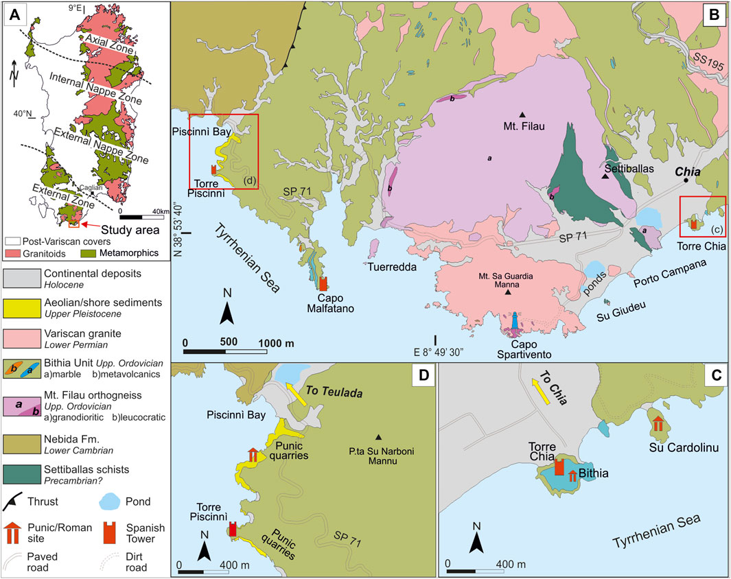
FIGURE 1. (A) Geological sketch map of Sardinia (after Carmignani et al., 2001, modified); (B) geological sketch map of the studied area, including all stops of the proposed itinerary (after Cruciani et al., 2018, modified); (C,D) details of the first and last stops, respectively, showing geological features not visible in the (B) image.
The aims of this research are 1) to raise public and political awareness about geoheritage through the description of the most noticeable features in the study area; 2) to valorize these natural and cultural monuments highlighting the touristic and cultural/didactic potential, paying attention to a sustainable development; and 3) to suggest possible solutions regarding conservation and protection of these geosites.
Different sides of the geoheritage topic, with special regard to the assessment methods, are also discussed in the framework of the international scientific literature to contribute to the growing debate on the geoheritage and its evaluation.
The Sulcis region forms the south-western part of the metamorphic Palaeozoic basement of the Variscan Sardinia (Figure 1A), which, in turn, is divided into three main tectono-metamorphic zones, with a decrease of the metamorphic grade from NE to SW: 1) an internal (or axial) zone in north-eastern Sardinia, which continues in the southern Corsica basement; 2) a nappe zone, further subdivided into external and internal nappes, in south-eastern, central, and north-western Sardinia; and 3) a fold-and-thrust belt, belonging to the external zone, in south-west Sardinia, also referred to be the foreland of the chain (Carmignani et al., 2001; Cruciani et al., 2015). The metamorphic basement is intruded by late Variscan granitoids, which form the Sardinian batholith. The reader is referred to Cruciani et al. (2001, 2008a, b, 2012, 2014, 2015), Massonne et al. (2013), and Fancello et al. (2018) for further information on the geology and metamorphism of the rocks of the axial zone.
The nappe zone is made up of a low/medium metamorphic grade metasedimentary sequence with intercalated a volcanic succession, ranging in age from the Upper Cambrian to the boundary Ordovician-Silurian, which lies on a thick Cambrian siliciclastic succession (Arenarie di San Vito Fm.) and followed by Middle-Ordovician and Upper Ordovician-Lower Silurian metapelitic-carbonatic successions (Punta Serpeddì Fm., Black Shale Fm., Villasalto Limestone Fm.) (Oggiano et al., 2010; Cruciani et al., 2016, 2017). The reader is referred to Cocco et al. (2018) for a complete review of the geology of the nappe zone.
The external zone comprises the oldest rocks of the Sardinian basement that, due to the complex polyphase deformation and metamorphic history, raised a decades-lasting scientific debate in the geologist community. According to the former interpretation (Carmignani et al., 2001 and references therein), the Settiballas schists Fm. (outcropping exclusively in the study area) represent a Precambrian(?) sequence intruded during the Ordovician by granitoids (the protolith of the Monte Filau orthogneiss) and overlaid by the Precambrian Bithia Fm. (Junker and Schneider, 1983). This Precambrian sequence lies below the Cambrian Groups (or formations) of Nebida, Gonnesa, and Iglesias (Pillola et al., 1995).
The new interpretation of the geological setting of this area totally reconsiders the significance of the Bithia Fm. The U-Pb radiometric dating of zircons from a metavolcanic layer within the Bithia succession (Pavanetto et al., 2012) provided an Ordovician age (457 ± 0.17 Ma) thus younger than the supposedly overlying Nebida Fm. (Lower Cambrian). These new data, coupled with the finding of a m-thick mylonitic contact between the two formations and with other structural evidence, led Pavanetto et al. (2012) to recognize this succession as an allochthonous tectonic unit formerly belonging to the external nappe zone and tectonically juxtaposed over the Lower Cambrian Nebida Group (belonging to the foreland); accordingly, the Bithia Fm. was renamed as “Bithia Tectonic Unit”. This new interpretation was also confirmed by a detailed microstructural study and by further U/Pb radiometric data (462.1 ± 4.3 Ma) on zircon populations from the same metavolcanics, corroborating the Ordovician age of the succession (Cruciani et al., 2018).
The Monte Filau orthogneiss is generally accepted as the metamorphic counterpart of a Middle Ordovician, type-S leucogranite (Cruciani et al., 2019b) intruded in a sedimentary succession (now the Settiballas Schists), and both metamorphosed during the Variscan orogenesis in Devonian-Carboniferous times. The subsequent Variscan orogenesis produced in the external zone an anchimetamorphic–epimetamorphic grade of metamorphism (Franceschelli et al., 2017).
The low-grade metamorphic rocks belonging to the Variscan basement are intruded by a huge plutonic complex being part of the larger Sardinian batholith, emplaced at the end of the Variscan orogenesis at about 320–280 Ma.
Although there are several studies concerning the geological, structural, and metamorphic evolution of the above-described rocks, the full geological significance of this sector remains a matter of debate in the scientific community, making it one of the most interesting areas in Sardinia from a geological point of view (Pavanetto et al., 2012; Costamagna et al., 2016; Cruciani et al., 2018; Cruciani et al., 2019b).
A detailed field survey has been performed to identify and characterize the most significant sites to be chosen as stages of the itinerary. Several photographs and the exact coordinates of each point have been acquired to allow everyone to recognize the site and its features even in the absence of a guide. Petrographic thin sections have been realized and studied by optical microscopy to fully characterize the outcropping rocks.
Seven geosites (also referred to as stages or stops of the itinerary) were selected based on the occurrence of at least three of the following features: geodiversity, significance of geological features in the regional framework (scientific interest), occurrence of didactic examples of geological features/processes (educational interest), closeness to archaeological and or ecological-rich sites (additional values), viewpoints or renowned beaches (aesthetic values), accessibility of the site, and proximity to touristic facilities (likelihood of the site to be visited).
The quantitative assessment of the geosites has been performed with the method of Brilha (2016), slightly modified to better meet the peculiarities of the here proposed itinerary. The reasons of this choice, among dozens of methods, are described in the Discussion section, whereas a summary of the main features of the method and the changes brought to it are here reported. The value assessment proposed by Brilha (2016) considers several parameters grouped into four main categories: scientific value (SV), potential educational use (PEU), potential touristic use (PTU), and degradation risk (DR). PEU and PTU share most of the parameters, but some of them are characteristic of one or another category. To each parameter, a value from 0 to 4 is assigned (hereafter referred to as the absolute value). The final score of each category is the weighted sum of the parameters that composed it. Weighted sum means that each parameter is multiplied by a percentage factor that depends on how important the parameter is within its category.
In this case study, the quantitative assessment is performed for each stop of the itinerary and then an average value is reported. Moreover, the final value of each category is reported in percentage to provide the reader a clearer result. Some slight adjustment to the calculation of Brilha (2016) has been made to better meet the peculiarities of the proposed itinerary. A summary of the different categories, with the constituent parameters and their weighting factors, is reported in Table 1.
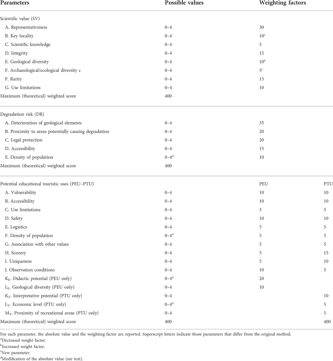
TABLE 1. Categories and parameters considered in the quantitative assessment of the geosite (modified after Brilha 2016).
The changes brought to the original method are described here. In the SV category, a new parameter has been added, that is, the archaeological and ecological diversity. This is an added value also for the geologist community since many studies in the past year are getting involved in multidisciplinary fields such as archaeometry or biogeology exploring the relationships between geology and the surrounding environment. On the other hand, the weighting factor of this new parameter (equal to 5) is intentionally low to prevent ecology/archaeology to overshadow the prevailing geological interest. In addition, the weighting factor of the geological diversity has been increased to 10 (from the former value of 5). To keep the total weight of parameters to 100, the key locality weight has been lowered to 10 from original 20. This choice was driven by considering the concept of significance as underlined by [Brocx and Semeniuk (2007), and references therein]; they discussed it in the light of both scale and rarity and concluded that a geological feature unique or rare in a given territory should be considered significant (at the local scale) even if quite common elsewhere. Since the key locality parameter as defined by Brilha (2016) implies an international or at least national significance, sites lacking such recognition are strongly penalized and, by reducing its weight factor, we partly reduce this disadvantage.
In the PEU and PTU categories, several adjustments were made. The didactic potential is here assigned based on the students’ levels (elementary, secondary, or university) to which it is possible to teach the geological features, rather than be based on what is already taught in schools; this better meets the literal meaning of the didactic “potential” (see the Discussion section for the explanation of this concept). Accordingly, the absolute value of the educational potential, assigned to each stage, has been modified considering what we suppose students of various levels could understand from each site.
The economic level parameter is based, in the original method, on the household income of the population living in the municipality hosting the geosites. This assumption disregards the contribution of thousands of tourists who every year visit the study area and the proximity to Cagliari (the Sardinia’s Capital) and its hinterland, where the average income is significantly higher than that of the villages in the study area (source, Italian Ministry of Economy1). Accordingly, an absolute value = 3 was assigned to the economic level.
The last parameter here modified is the density of the population; it is included in three categories, PTU, PEU, and DR. Like the economic level, this parameter considers solely the municipalities where the geosites are located, and in our case study, we should assign the lowest absolute value, 1; however, we decided to increase the value to 2 since the geosite is close to Cagliari (whose density of population would result in a value of 3 in the assessment method), where many people, in every season, come from. This modification affects positively the PEU and PTU but, at the same time, increases the DR since more people frequent a site and more it is likely that they contribute to its degradation.
The study area displays several didactic examples of geomorphological features as follows: 1) the southern slopes of the Sulcis orographic and hydrographic systems; 2) coastal alluvial basins and wetlands along the Chia plain; 3) a summary of the coastal landforms spanning from shores with aeolian dunes to vertical cliffs, from tombolos and sandy bars to drowned rias occupied by lagoons and delimited by rocky headlands (Figure 2). Moreover, a considerable geodiversity and a regional significance (sensu Brocx and Semeniuk, 2007) of geological features can be observed. In a few square kilometers, schists, metasandstones, quartzites, marbles, and orthogneiss belonging to the metamorphic Variscan basement are found together with the late Variscan granitoids (Pavanetto et al., 2012; Cruciani et al., 2018). Locally, this crystalline basement is overlaid in direct contact by quaternary sediments, thus marking a gap of more than 450 Ma (Table 2). Some of these rocks crop out only in the studied sector and, being among the oldest Sardinian rocks, represent a key for understanding the geological history of the whole island. The outcrops and the contacts between different rocks are commonly well exposed, and many geological features are so evident that they could be clearly explained to people lacking any geological background as well.
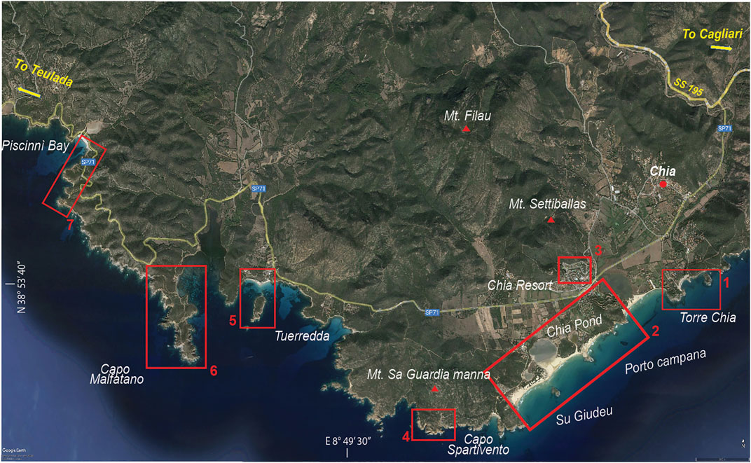
FIGURE 2. Satellite overview (from Google Earth) of the suggested stops for the geological, archaeological, and naturalistic itinerary.
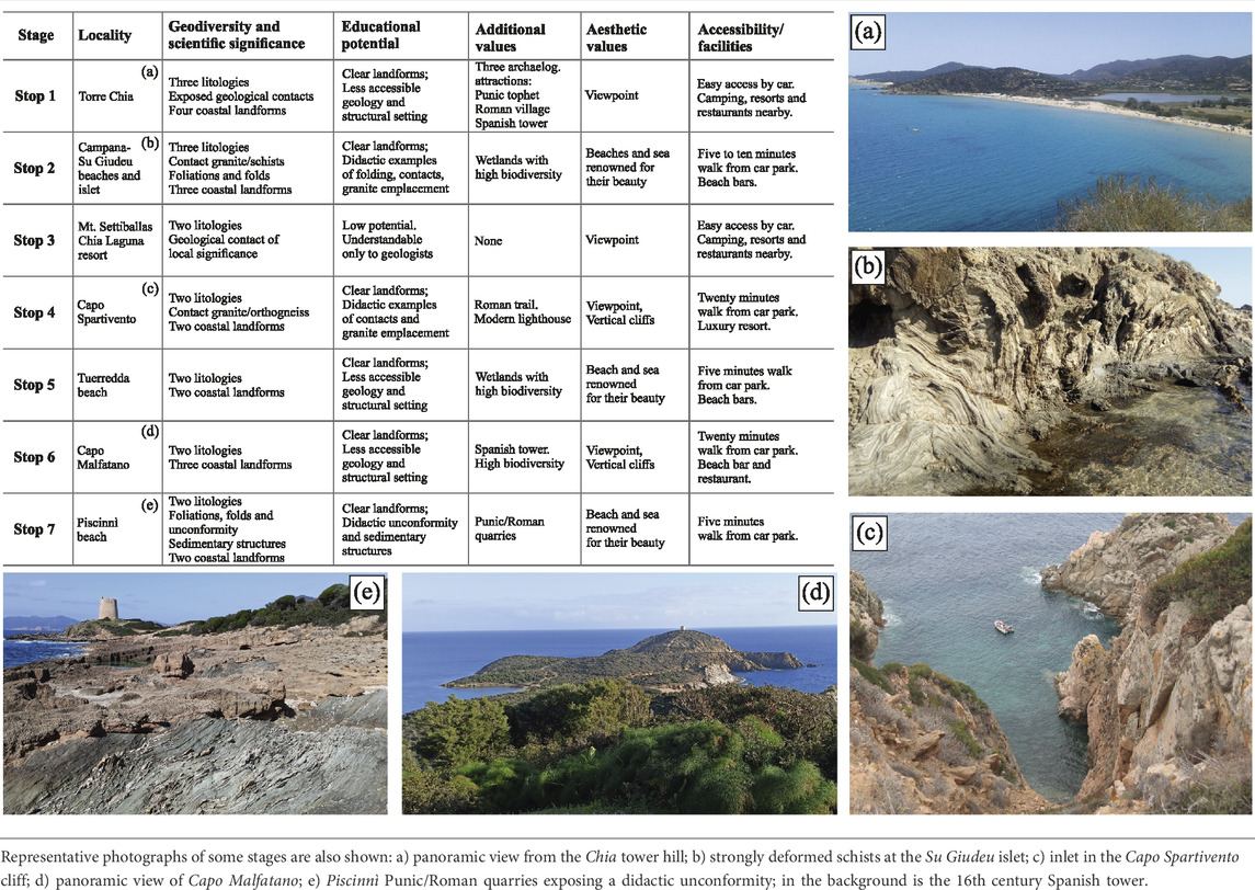
TABLE 2. Summary of the features of each stage grouped in five categories.
The above-described geological scenario is enriched by the archaeological remains of different civilizations, from Phoenician (8th century BC) to Roman (3rd century BC to 5th century AD) and finally Spanish (16th century). This area was extensively populated, especially in the Phoenician-Punic and Roman periods, with various settlements on the coast where the remains of the ancient village of Bithia (Bartoloni, 1996) on the promontory of the Chia tower (Torre di Chia), the harbor at Capo Malfatano area, and the ancient quarries of Piscinnì, with the extractive fronts still intact and recognizable, can still be seen today. These archaeological sites are part of a wider itinerary of the south-western part of Sardinia, starting from Cagliari (e.g., Roman amphitheater, Early Christian San Saturnino Basilica, Romanesque Cathedral and others; Columbu et al., 2017, 2018, 2022) to the Punic-Roman site of Nora, which preserves buildings and materials of a high historical value (i.e., theater, thermal baths; Columbu and Garau, 2017; Columbu, 2018; Columbu et al., 2019), to the important Phoenician-Punic settlements of Monte Sirai (Bartoloni, 2000; Perra, 2009), Sulki village (today Sant'Antioco) (Bartoloni, 1988; Pompianu, 2010), Antas site with Punic-Roman Temple (Columbu et al., 2021), and several Nuragic structures in the westernmost part where several archaeological finds have been found as well as in other areas of Sardinia (Bertorino et al., 2002). In addition to the civil settlements of classical age, several coastal watchtowers [i.e., the towers of Chia (near the village of Bithia), Capo Malfatano, Capo Spartivento, and Piscinnì] built around the 16th to 17th centuries constituted a unique defensive system, transformed into a cultural and tourist network today and appreciated and visited by hundreds of tourists.
Not only civil and military settlements are scattered within the territory but also well-preserved ancient mines (mainly lead and zinc) and quarries that establish an ideal link between geoheritage and archaeological heritage are present.
The itinerary proposed here is enclosed in the municipalities of Domus de Maria and Teulada towns and follows a transect along the coastline between the Chia village (in the east) and the Piscinnì beach in the eastern side of the Teulada Gulf (Figure 2). As outlined in the Methods section, seven localities (stages or stops) have been selected considering the occurrence of specific features grouped in five categories (Table 2): geodiversity/geological significance, educational potential, additional values, aesthetic value, and accessibility/facilities. To be selected, each site must exhibit several geological features (including but not limited to lithologies, landforms, processes, structures as folds and foliations, etc.), thus satisfying the criteria of geodiversity/geological significance. In addition, at least other two different categories must be fulfilled. The basic idea is to propose sites that, besides the geological interest, can also be attractive from different points of view to reach an audience as wider as possible. Note that audience is not only intended in a touristic way but also includes scientists, students of various levels, and amateurs of geology and/or archaeology.
The selection criteria led to exclude several localities that, although beautiful and valuable as touristic attraction, lack the geodiversity requirements since totally hosted in the metapelites of the Bithia Fm., the most widespread lithology in this area. Many viewpoints located along the panoramic coastal road were excluded due to the scarce geodiversity as well or to the lack of additional values. In other cases, outcrops geologically interesting for scientists were excluded for their low educational potential (difficult to be explained to laypersons) and for the low aesthetic value.
The detailed description of each stop and the geological/petrographic features of each lithology are reported in Detailed description of the itinerary and Geological and petrographic features of rocky outcrops and geomaterials, respectively, which, if separated from the main paper, could serve as a field guide. A summary of the main features of each site is reported here and schematized in Table 2.
Stop 1—Chia tower. It consists of a promontory where three different rocks (metapelites, marble, and skarn) can be observed. The contact between marble and metapelites is well exposed. Landforms as promontory, tombolo, gravelly beach with sandy dunes and a river mouth can be observed. The civil settlement of Bithia (Punic and Roman ages), a Punic tophet, and a Spanish watchtower of the 16th century represent an additional historical value. The aesthetic value is ensured by the viewpoint from the top of the hill from where landforms can be clearly seen and explained (educational value). The site is well accessible and rich in facilities for visitors.
Stop 2—Porto Campana—Su Giudeu. The beaches of Su Giudeu, Porto Campana, and Sa Colonia represent a geologically rich area with didactic coastal landforms (beach, dunes, ponds) and different rocks represented by Settiballas schists intruded by a late Variscan granitoid and finally cut by aplitic dikes outcropping in the Su Giudeu islet. The additional value is represented by the biodiversity-rich environment of the wetlands behind the beach. The aesthetic value is undisputable and well known to tens of thousands of tourists who come to this locality every year.
Stop 3—Mt. Settiballas—Chia Laguna resort. In this hill, the contact between the Ordovician orthogneiss of Monte Filau and the Settiballas schists can be observed. Geology is hardly understandable for laypersons, but this contact has high significance for geologists and thus a high scientific value. The aesthetic value is provided by the panoramic view from this poorly known point that allows to see the whole alluvial plain of Chia and most of its beaches. Facilities for visitors are a nearby resort and the easy access by paved road.
Stop 4—Capo Spartivento. This rocky promontory is made up of a late Variscan granite intruding the Ordovician orthogneiss. Cliffs up to 60 m a.s.l. cut by decameter-wide inlets provide a great aesthetic value and a wide panoramic view. Additional values and facilities consist of a lighthouse (now an exclusive resort) and a roman trail leading to the Mt. Sa Guardia Manna hill that offers an even wider view.
Stop 5 — Tuerredda beach. Tuerredda is one of the most renowned beaches in the south-west Sardinia. It is emplaced along a fault marking the contact between the Monte Filau orthogneiss and the Bithia Unit, both visible on the beach edges. Geological features are not easy to understand and so have a low educational potential. Additional value consists of a wetland below the dunes hosting a significant biodiversity.
Stop 6—Capo Malfatano. It is a rocky headland consisting of Variscan metamorphic rocks belonging to the Bithia Unit and showing all its facies (metapelites, marble lenses, and metavolcanics) and the deformations produced during the Variscan orogeny. Coastal landforms, dominated by cliffs, inlets, and a drowned ria (now occupied by a lagoon), have a didactic and aesthetic value. Additional value is given by the 16th century Spanish tower.
Stop 7—Piscinnì beach. From a geological point of view, an unconformity between the Bithia Unit and the Upper Pleistocene sandstones can be observed, marking a gap of more than 450 Ma. This feature is so clear and well preserved that its didactic potential is certainly high. The additional values consist of Punic/Roman quarries, where the original shapes of the carved ashlars are still visible, and of Spanish watchtower. The aesthetic value is provided by the white sandy beach and by the quarries that are sometimes drowned forming pools filled by crystalline water.
In summary, each geosite is characterized by a geology-rich heritage mainly consisting of metamorphic rocks, granitoids, and locally sedimentary covers. The strong and polyphase deformation produces structures with high significance for structural geologists and that are so well preserved that they can be used as didactic examples for students. A summary of the main coastal landforms is also observed from beaches, dunes, and ponds in the eastern area to the rocky headlands, cliffs, and rias in the western area. The didactic potential, as intended in this paper, is commonly high since many geological features are evident enough to be explained to everyone. Additional values are present in six sites out of seven and are mainly represented by archaeological sites and/or by biodiversity-rich ecosystems. The aesthetic value is undisputable in the whole territory; viewpoints tens of meters above the sea level or beaches with fine-grained golden sand and emerald-turquoise crystalline seawater attract thousands of tourists from all over the world every year. Facilities for visitors are well developed, offering all kinds of accommodation and foods for all budgets and needs.
The results of the quantitative assessment of the here proposed itinerary, performed according to the method described in Methods, are reported in Table 3 and summarized in this section, whereas the pros and cons of the method are described in the Discussion section. For each stop, the absolute and weighted values of each parameter and the final score of each category are reported. The last column reports, for each parameter and category, the average weighted value of the whole itinerary reported in percentage.
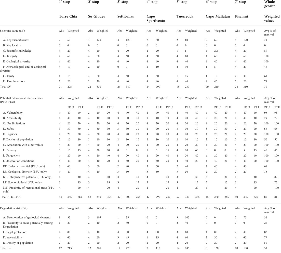
TABLE 3. Results of the quantitative assessment of the geosite’s value performed following a modified version of the method proposed by Brilha (2016).
The final scientific value (SV) category scores 70%, testifying a good scientific value of the study area. The most penalizing parameters are represented by the lack of a nationally or internationally recognized key locality within the itinerary, supporting the need to lower the weight of this parameter when dealing with sites with local significance. The archaeological/ecological diversity lowers the total value of the SV category since each stop is treated separately, and thus, some of them, lacking this kind of feature, negatively affect the final weighted average.
The potential educational use (PEU) and potential touristic use (PTU) categories show high values of 80% and 81%, respectively. Surprisingly, the lowest value (46%) is assigned to the scenery parameter, that is, the beauty of the site (see the Discussion section for the explanation of such a low value). Another parameter lowering the total scores of PEU and PTU is the density of the population, which, even if modified to consider the proximity of Cagliari (the absolute value increased from 1 to 2), remains quite low. Finally, the safety conditions contribute to lower the total scores of PEU and PTU. The barely sufficient weighted value of 68% does not mean that the itinerary is dangerous for tourists and/or students but mainly reflects the lack of emergency structures in close proximity. Most of the sites have safety facilities as easily walkable and marked trails, boardwalks, and fences, but in places like Piscinnì ancient quarries and Capo Spartivento, a safety improvement would be useful. High scores in the PEU and PTU categories are provided by the facilities (logistic, accessibility, accommodations, etc.), the possibility to observe and interpret the geological features, and the low vulnerability.
The degradation risk (DR) category is separately discussed to better highlight the site vulnerability and to discuss the possible actions aimed at its conservation. Table 3 provides a clear overview of the most sensitive parameters of each stage, supporting the usefulness of the quantitative assessment of the geosite features. The overall percentage score of DR = 51% reveals a low to moderate degradation risk of the whole geosite. The highest value (which means a high degradation risk) is related to the parameter of legal protection scoring of 82%. In vulnerable areas as the dunes of Su Giudeu, walking or camping is forbidden, but there is no control of accesses and, during the summer, it is quite common to observe tourists walking on the dunes. The Piscinnì quarries as well are in a restricted area under the supervision of the Superintendency of Cultural Heritage, but there is a lack of a real access control. In other areas such as the stages of Settiballas, Capo Spartivento, and Capo Malfatano, no restrictions are in force, further lowering the total score of this parameter. The other problematic parameter (79%) is the accessibility of the geosite since almost all sites are easy to be reach: the easy access of people is an advantage to the PEU and PTU categories but, at the same time, increases the degradation risk. On the other hand, it should be said that various stages of the itinerary are not really sensitive to deterioration; geological features such as the contact between granite and orthogneiss at Capo Spartivento or the decametre-thick marble lenses at Capo Malfatano are difficult to be destroyed by natural or anthropic agents, so their degradation risk is low, even in the absence of legal protection and/or with high anthropogenic pressure.
Considering each stage separately, it is possible to assess the most vulnerable ones. They are the beaches of Su Giudeu and Tuerredda where the high presence of visitors, especially in summer, is associated with a significant vulnerability of some geological features, especially the dunes but also the islets that are reached by thousands of people every year. Not only human pressure but also natural causes can result in the degradation of these geosites. The coastal erosion driven by changes of the dominant marine currents, by storm events, and by the sea-level rise, whose impact is predicted to increase due to the global warming (Nerem et al., 2018), strongly threatens the coastal sites, both of geological and of archaeological interest (Reimann et al., 2018). Current evidence of the erosional processes can be observed at the quarries of Piscinnì where several blocks of sandstone, up to several meters in size, are collapsing or are already collapsed under the wave action. Moreover, the most interesting quarry floors lie just 1 or 2 m above the sea level and so are impacted by flooding during storm events. No degradation risks, neither from natural events nor from the human activities (here very limited), have been detected for the two sites of this itinerary that are well above the sea level, which are the Settiballas and Capo Spartivento stops.
The main purposes to institute a new geosite (or geotrail) are its protection and its valorization, and the better way to do it is by assessing the risk factors and the potentialities of the site. In this paper, the quantitative assessment revealed a low to moderate degradation risk for most of the geosites but highlighted that some of them are endangered due to coastal erosion and human activities. However, the current conservation state of the sites is commonly quite good. Geological features such as the Bithia outcrops, the contacts between different lithologies or facies, and the quaternary sandstone sequences are well exposed and, except for the local collapses of the latter, do not show evidence of substantial decay. The vulnerable dune systems of Su Giudeu and Porto Campana have even increased their average height and width in the past years thanks to a series of interventions (boardwalk to cross dunes and ponds, fencing of dunes, chess-shaped cane barriers) funded by the Sardinia regional government and realized by the municipality of Domus de Maria (Costa et al., 2014).
A good conservation state does not mean that further interventions are not necessary. On the contrary, there is a need to prevent a possible deterioration, which would be enhanced if this site will becomes a geosite in the future. Obviously, we cannot deal with global issues such as the sea-level rise or the increased occurrence of extreme weather events due to the climate change, but it is possible to act for limiting local risks like those produced by the anthropic activities. Without exploring the vast topic of geoconservation, already examined by several authors (Wimbledon et al., 1995; Prosser et al., 2006; Brocx and Semeniuk, 2007; Ellis, 2011; Gray, 2013; Gordon, 2018; Prosser, 2018), we would like to suggest some low-cost conservation interventions. First, the area should be better monitored to control the accesses to vulnerable and protected areas and to prevent the geosites from visitors’ misconducts. The installation of fences and low-impact boardwalks (like at Su Giudeu beach), the refurbishing of old trails, and the placement of posters reporting the rules for a correct site fruition could protect the most vulnerable sites and, at the same time, enhance visitors’ safety.
As regards the valorization of the geo-itinerary, this paper intends to be the first step in this direction. Several geosites within the Variscan basement have been proposed in the past years in different countries, for instance, in Germany (Wrede and Mügge-Bartolović, 2012), Czech Republic and Poland (Alexandrowicz, 1998; Migoń and Różycka, 2021), Spain (Fuertes-Gutiérrez and Fernández-Martínez, 2012), Morocco (Mehdioui et al., 2022), and hundreds of others. A comparison between the here proposed itinerary and other geosites worldwide would be meaningless since each geosite has its own peculiarities (geological features, additional values, potentialities, facilities, etc.) and thus too many parameters to be considered. In addition, the vast literature and the use of different assessment methods make it hard to analyze any kind of comparison (Štrba et al., 2015). What can be done here is highlighting the strong points of our itinerary, and the better approach is the quantitative assessment. It testifies a good scientific value (70%) and even higher values of educational (80%) and touristic (81%) potentials. Also, the calculation allows to identify the strong and weak points of the itinerary and to act, where possible, to enhance its potentialities.
The high SV is provided by the state-of-art knowledge, the geodiversity, the integrity, and the accessibility of outcrops, whereas the lack of key localities lowers the total score (see below). The parameter of archaeological/ecological diversity, which we added to the original method, does not significantly affect the final score that would change from 70% to 68% if the parameter is not computed. Most of the parameters in the SV category cannot be improved since they are intrinsic features of the territory. However, it is possible to increase the parameter of the scientific knowledge by performing further geological studies and by attracting international scholars, for instance, through the organization of congresses or summer schools for Ph.D. students focused on this area.
Contrarily to SV, the already high values of PEU and PTU can be further increased by intervening on the low-scored parameters. The scenery parameter (the geosite beauty) scores just 48% since it depends on whether or not the site is promoted in local or national touristic advertising campaigns. This is, in our opinion, a pitfall of the evaluation method (see below), but it provides interesting information; except Su Giudeu and Tuerredda beaches, the other sites are almost totally neglected by touristic campaigns and are accidentally visited by tourists who reach this area attracted by the beaches. Thus, the potential of the whole area could be easily improved by promoting the less known geosites. Other parameters quite easy to improve are the safety and accessibility of the geosites that, using the same strategies proposed for limiting the degradation risk (on-site informative posters, fencing, boardwalks, trails), would be automatically increased. These actions would serve to attract tourists who are already in the area, but, as argued by Mikhailenko et al. (2021), the accessibility of a geosite (as well as its attractiveness) should also consider a potential outer audience; it means involving visitors who reach the area specifically to visit the geosites they have already heard about. National and international touristic/advertising campaigns would be the better way to achieve this goal and, at the same time, would enhance the scenery parameter.
Several parameters in the PEU and PTU categories are already at the top level (use limitations, logistics, association with other values, uniqueness, observation conditions, proximity to recreational areas) and so do not need any improvement and represent the strong points of this itinerary, especially the additional archaeological/ecological value. The latter represent the very peculiarity of the itinerary since most of the geosites offer more than geology and thus can also be attractive for people not specifically interested in this discipline. Other parameters have a low score (density of population, economic level) but cannot be significantly improved just by promoting a geoitinerary.
To conclude this section, a summary of practical actions to valorize the itinerary is proposed: 1) information campaigns to raise public awareness about the great hidden value of these sites, which should involve all the stakeholders; 2) involvement of the scholar community in new research/educational projects; 3) a monitoring service possibly carried out by a qualified staff that could also address visitors to the less known attractions and to explain the geosite features; 4) improvement of signage and infrastructures to protect the geosites and the visitors; and 5) involvement of local administrations in large-scale land management. In addition, the preservation and the development (cultural and economic) of this territory should pass through the membership to regional, national, or even international networks of protected zones and parks as already done for the Su Giudeu beach that belongs to the “Natura 2000” network.
Finally, we suggest that the Detailed description of the stops and the Geology and petrography of outcropping rocks could be presented in the form of a leaflet or brochure to be used by tourists, students, geology enthusiasts, and scholars as a field guide of the attractions (especially the less known ones) of this territory.
The main purpose of this work is the valorization of an area that offers to visitors (tourists, students, scholars) plenty of attractions, with most of them neglected, unrecognized, or undervalued. A comprehensive overview on the methodological approaches for geological heritage assessment would be beyond the scopes of this paper; however, a discussion about different assessment methods and concepts at their bases is required to justify the preference of a method to another and also to contribute to the growing debate about geoheritage.
Quantitative methods are commonly based on an easy-to-understand principle, that is, the identification of several parameters, sometimes grouped in categories, to each of which a numerical value is assigned (Pereira et al., 2007; Reynard et al., 2007; Ruban, 2010; Rybar, 2010; Bruschi et al., 2011; Fassoulas et al., 2012; Štrba et al., 2015; Brilha, 2016; Ruban et al., 2021). A total rank is so obtained; it can be related to the maximum rank allowed by the method, and/or it can be compared to other sites where the same method was used. If the underlying idea is straightforward, its application is by far more complex. Different parameters, different scores and calculations, and even different concepts and meanings of the same parameter can be found in the literature. The value assignment to a geosite can be further complicated by the occurrence of additional values such as archaeological-cultural and/or ecological features (Reynard et al., 2007; Moroni et al., 2015; Migoń et al., 2018). Many aspects of the geoheritage topic are more multifaceted than one can imagine, deserving studies focused on them. What is geodiversity and how can it be quantified (Gray, 2008; Ruban, 2010; Brilha et al., 2018)? What “geosite value” means (Strba and Rybar, 2015)? Who benefits from this value (Brocx and Semeniuk, 2007; Hose, 2008; Štrba, 2019; Benedetto et al., 2022)? What is the aesthetic value of a site (Kirillova et al., 2014; Mikhailenko et al., 2017)? How should the visibility (Mikhailenko and Ruban, 2019) and accessibility (Mikhailenko et al., 2021) be weighted in the final rank of a geosite? How and why should we protect the geological heritage (Prosser et al., 2006; Gray, 2013; Migoń and Pijet-Migoń, 2017; Gordon et al., 2018)? These and many other questions were answered by researchers in the past decades, contributing to a productive debate that is still active and evolving. On the other hand, this growing literature makes difficult the site-focused studies since authors have to select the most significant parameters to be considered (and those to be neglected), to assign them a score, to opt for a “school of thought”, and to choose a calculation method. This obviously results in the impossibility to compare the values obtained through different methods as highlighted by Štrba et al. (2015).
In this case study, the choice of the method (Brilha, 2016) was driven by several considerations. It considers a great number of parameters, most of which are easy to understand even for lay persons, and thus, it can be easily explained to local stakeholders (local governments, tour operators, investors, tourists). It does not require complex calculations or statistical analyses, so it is quite easy to be applied. The score of each parameter is weighted relative to the category it belongs to so that each category expresses a total score that considers the importance of each single parameter, rather than being just the sum of them. It is relatively recent, so it considers the contributions proposed by many other authors during the past years. Finally, it is one of the most cited, indicating a wide recognition by scholars’ community and, more importantly, facilitating the comparison between the here proposed geosite and other geosites throughout the world.
Obviously, there is no method that is absolutely and objectively better than others, and the same method could be well tailored to some case study and less suitable in others. The method by Brilha (2016) used in this work also has its own pitfalls.
The parameters enclosed in the SV category could be, in our opinion, better weighted. The key locality has a heavy weight (20) and affects the whole scientific value, lowering the total score of sites lacking this recognition but having local or even international significance. The latter could be better evaluated considering, for instance, the number of international scientific papers dealing with the site geology. On the contrary, the parameter of geodiversity, one of the most important concepts in geoheritage (Gray, 2008; Crofts, 2014; Brilha et al., 2018), has a very low weight (5). In addition, just three geological features in the same site (this includes rocks, minerals, fossils, landforms, processes, etc.) are enough to assign it the maximum absolute value of this parameter, further undervaluing geodiversity-rich sites. Didactic potential, as already discussed in the Methods section, should be intended as what students of various levels can understand from a specific geosite, rather than be based on what is already taught in schools. We cannot assess what students can understand (actually, we do not even know what is taught in schools of various levels, in different countries), but some general constrain can be proposed. Geomorphological forms and processes as dune formation, cliff erosion, and alluvial plain development can be considered easy-to-understand concepts, even for primary school students, since they are ongoing processes, whose effect is clearly visible and which do not require preliminary knowledge. Similarly, some structural features as folds, foliations, and unconformities, when evident (as in this study area), can be shown and explained to young students (primary or secondary schools). On the other hand, the geologic significance of these structures and the geodynamic framework they belong to require basic knowledge of geology and thus are considered harder concepts. Metamorphic processes are even more difficult to be explained since they are based on mineralogical, petrographic, and geochemical principles accessible to students at the university level. Another parameter that could be better measured is the scenery that is the aesthetic value of a geosite; in the method of Brilha (2016), it is evaluated based on whether or not the site is a destination of tourism campaign and thus does not consider the real beauty of the site. Other authors (Pralong, 2005; Kirillova et al., 2014; Migoń and Pijet-Migoń, 2017; Vukoičić et al., 2018) have tried to quantify the scenery on the basis of more rigorous criteria such as the number of viewpoints and width of view, height contrasts and landscape elevation, color contrast, and many others. These methods are more objective but often require the acquisition and elaboration of geomorphological data and so are more difficult to be applied.
In this work, some parameters were modified or introduced to better match the features of the proposed itinerary and to partly solve some of the above-mentioned criticisms. With this discussion on methods, parameters, and even concepts, in the framework of the international scientific literature, we have also tried to bring our constructive contribution to the geoheritage topic.
The detailed description (See below) and the quantitative assessment testify the high value of this sector, characterized by various complex and articulated aspects of great interest.
The noticeable geodiversity is manifested by the occurrence of metamorphic rocks belonging to the Variscan basement, intruded by late Variscan granitoids and unconformably covered, after a gap of about 450 Ma, by quaternary sediments. Also, from a geomorphological point of view, a wide geodiversity is observed: the southern slopes of the orographic system represented by rocks belonging to the crystalline basement; alluvial coastal plains, partly covered by wetlands, that collect the streams flowing down from the mountains; and a summary of the most common coastal landforms. Moreover, structural features such as foliations, folds, kinematic indicators, unconformable contacts, and so on are well expressed. All these features make this area an ideal place for teaching geological processes to every kind of audience.
Beyond the geological heritage, the study sector offers additional values represented by ecological diversity and archaeological attractions: the faunal and floral richness of the wetland environment, the widespread Mediterranean maquis shrubland, and the nearby centuries-old forest of Is Cannoneris. The archaeological heritage, as well, is rich and various, being characterized by earlier Phoenician settlements, followed by Punic and Roman ones and by far recent Spanish towers resting on panoramic headlands. The link between the human occupation, the territory exploitation, and the geology is established by the well-preserved ancient quarries of Piscinnì.
All these features are set in a land already known for its beautiful landscapes and coasts and that is already equipped to face with tens of thousands of tourists every year, so the facilities for the visitors of a desirable future geopark would be readily available.
The seven sites forming the proposed itinerary are below described paying attention mainly to the geological features and to the archaeological sites, and subordinately to the ecosystems and biodiversity. The petrographic features of each lithology found in this itinerary are also described to complete the geological background, mainly addressed to geology students and scholars.
Stop 1. Chia tower (Figures 2, 3). This stop is located between two promontories separated by a sandy/gravelly beach (Figure 3A). The southern promontory is dominated by the Chia tower hill, where the archaeological site of the Punic-Roman centre of Bithia and a 16th century tower were built. The northern promontory is actually an islet that is sometimes connected to the coast by transient sandy bars (tombolo).
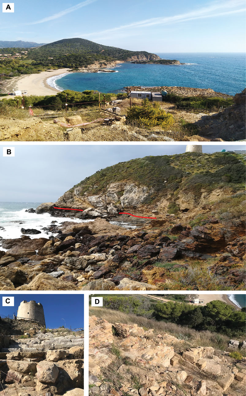
FIGURE 3. (A) Panorama from the tower looking toward east; (B) overview of the geology of the Chia tower hill—the red line highlights the transition between, from bottom to top, dark phyllites and metadolostones/marbles of the Bithia Formation; (C) Spanish tower overlooking the Bithia ruins; (D) Bithia Punic/Roman ruins.
Beyond the nice landscape—consisting of cliffs, the islet, the river mouth of Rio di Chia, the backshore dune system covered by a sparse pine grove and a beach separated into two parts by a whitish marble outcrop—various highly deformed rocks of great geological interest, can be observed: looking at the Chia tower hill from the sea (Figure 3B), the sub-horizontal contact between a brownish, highly-deformed metapelite (bottom) and a yellowish, massive to highly fractured metalimestone/metadolostone (top), forming the promontory on which was built the Chia tower (Figures 1C, 3B), can be recognized.
The Bithia archaeological site, whose visible part rests mainly on the Chia tower hill (Figures 3C,D), testifies the sequence of different civilizations likewise in other Sardinian ancient villages. The Bithia discovery occurred in 1926 after a coastal storm and was followed by several excavation campaigns that allowed to outline the site history. The remains of a ceramic amphora date the Phoenician presence at least since the end of the VIII century B.C. (Zucca, 1985); barely coeval finds of Nuragic-made containers, testify the interaction between Phoenician and indigenous populations (Bartoloni, 1996). During the VI century B.C. the village was conquered and occupied by the Punic and, after a period of partial decline during the V century, marked by a population decrease, was repopulated, and involved in fortification works. The Roman period started at the end of IV century B.C. and lasted until the end of IV century A.D., even if the decline of Bithia, probably linked to the infrastructure decay, began several years before (Bartoloni, 1996).
The ruins of Bithia are scattered in a wide area surrounding the Chia tower cape but are currently visible in few places. The most important site is in the north-eastern side of the Chia tower hill where excavations brought to light the remains of the edifices of Roman and Punic age. The islet of Su Cardulinu still preserves traces of ancient worships testified by the ruins of a Phoenician tophet (i.e., an outdoor sanctuary) and of a subsequent Punic sanctuary surrounded by the temenos (= boundary walls). Finally, the Necropolis, designated by the three civilizations in the littoral dune system in the backshore of Sa Colonia beach, is represented by different kind of burials that are barely visible due to the dune coverage.
Another archaeological attraction of this area is the Chia tower (Figure 3C) that gives the name to the whole area. It is a Spanish tower with circular cross section of 10 m in diameter and 13 m in height, built to prevent pirates from disembarking to supply fresh water. The construction, planned since 1572, was completed in 1592 and followed by several restoration interventions.
Stop 2. Porto Campana – Su Giudeu beaches (Figures 2, 4). Moving from the Chia tower toward south-west, there are the three above-cited beaches separated one by another by decametre-sized rocky headlands and by the Monte Cogoni hill (Figures 4A,B). These beaches are visited every year by tens of thousands of beachgoers attracted by the crystal-clear emerald/turquoise sea and by the fine-grained golden sand, but this territory offers even more. This is a Site of Community Importance (SCI - ITB 042230) as defined by the EU directive 92/43/CEE and part of the “Natura 2000” network aimed at protecting sensitive and vulnerable habitats. Indeed, this tract of coast is characterized by a dune system, discontinuously extending along the shores for approximately 2.5 km in length (Buosi et al., 2019b). The maximum width and height of dunes (200 m and 10–12 m, respectively) is reached behind the islet of Su Giudeu. The dune system is less developed in the Campana beach where dunes reach heights of 10 m and widths of 70 m and even less in the Sa Colonia beach (in the northern sector, at the base of the Chia tower hill). These dune systems are considered moderately vulnerable (Ciccarelli et al., 2017) due to the marine/aeolian erosion and to the human impact. The foreshore is characterized by a well-structured area of bars and troughs, and it is bounded offshore by the Posidonia spp. prairie.
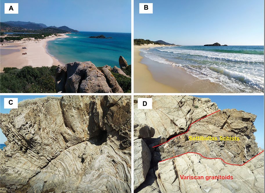
FIGURE 4. (A) View (toward SE) of the Su Giudeu and Porto Campana beaches with their dune system and the Su Giudeu islet on the right; (B) view from the shore of the Su Giudeu islet; (C) open, asymmetric folds in the Settiballas Schists outcropping in the Su Giudeu islet; (D) intrusive contact between the Settiballas Schists and late Variscan leucocratic granitoids, visible at the Su Giudeu islet.
This area has also a great environmental importance since hosts a “Coastal dunes with Juniperus spp.” European habitat code 2250 (Picchi, 2008) a complex and vulnerable habitat consisting of several floral and faunal species, threatened by alien plants and anthropic disturbance (Pinna et al., 2019). The back-dune area is a wetland largely occupied by three ponds namely the Stagno di Chia, the Stangioni su Sali and Campana (Figure 4A) whose water is mainly supplied by small seasonal rivers, namely Riu Baccu Mannu and Riu Perdosu. Width, depth, and salinity of the ponds are mainly controlled by the seasonal rainfalls and subordinately by the interaction with sea water. The latter occurs occasionally during flood events that can open channel mouths. The wetland environment, as well as the dune one, represents an ecological niche to be protected since hosts rich floral and faunal assemblages; the latter includes several species of waterbirds that use to stop in these ponds during the migratory journeys (Ferrarini et al., 2021). In addition, the Sa Colonia beach is a site of nidification for the Caretta caretta turtle.
Finally, the Su Giudeu islet is worth to be mentioned (Figures 4A,B). It is a small (<8000 m2) rocky islet, locally covered by sparse vegetation, emerging at about 100 m from the water edge, that can be easily reached by feet thanks to a sandbar extending orthogonally from the shore. It consists of both metamorphic and magmatic rocks, the former mainly outcropping toward the beach, the latter toward the sea. Metamorphic rocks are metapelites belonging to the Settiballas Schists that here exhibit amazing folds highlighted by alternating dark- and light-coloured layers (Figure 4C). Folds vary in size (from metric to centimetric), in shape (isoclinal, kink, box-fold) and geometry (horizontal, vertical, inclined), testifying the strong tectonic accident these rocks underwent in the remote past. Magmatic rocks are represented by an undeformed, massive Variscan granite hosting centimetric to metric mafic enclaves and cut by fine-grained leucogranitic dikes, therefore three generations of magmatism are represented in this small islet. The contact between metamorphic and magmatic rocks is impressive since it is possible to observe at the metric scale the granite literally incorporating the schists (Figure 4D).
Stop 3. Mt. Settiballas – Chia Laguna resort (Figure 5). Few 100 m from the coast, the Mt. Settiballas hill rises above the Stagno di Chia (Chia Pond). The hill is largely occupied by the Chia Laguna resort and by several detached houses with gardens and pools. The main road winding up the hill offers a perfect sightseen of the whole area, including the coast, the tower of Chia, the three ponds and the alluvial valley of Chia. Moreover, the hill itself represents an interesting example of the geology of this area. Along the road cuts, it is possible to observe the Settiballas Schist Formation, probably the oldest Sardinian rock, and its intruding rocks, the younger Monte Filau Orthogneiss. The contact between the Settiballas Schists and the Monte Filau Orthogneiss is well exposed and appears along a road-cut in the northernmost road of the Chia Laguna complex (Olivastro Street, coordinates: 38°53'56.75"N, 8°52'2.66"E); here, looking toward north, the darker rocks belonging to the Settiballas Schists Formation can be recognized on the left, whereas the lighter meta-igneous rocks of the Monte Filau Orthogneiss outcrop on the right. The contact is a sub-vertical, tectonically disturbed intrusive contact (Figure 5B) formed about 460 million of years ago when the Monte Filau Orthogneiss (a granite at that period) was emplaced into the Settiballas Schists, probably a pelitic-psammitic sequence at that time. The contact is in turn intruded by a tectonised highly fractured leucogranitic (cm-thick) vein of late Variscan age. The Settiballas Schists are metapelites-metasandstones, the former characterized by typical andalusite porphyroblasts aligned with the foliation (Figure 5C), which testify the past thermal metamorphism that affected these rocks; these mineralogical features are well-recognizable in proximity of the above-described contact. The orthogneiss intruding the metapelites is composed of three different petrographic facies: two leucocratic facies, from fine-grained to coarse-grained, and a biotite-rich facies. The leucocratic facies are both recognizable in proximity of the contact, with an increase in the grain size away from it; the fine-grained facies is characterized by mm-thick, dark aggregates oriented with the main foliation.
FIGURE 5. (A) View (toward SE) from the Settiballas hill of, from left to right, the tower of Chia, the Sa Colonia Pond, and part of Mt. Cogoni hill; (B) contact between the Settiballas Schists and the Monte Filau orthogneiss at the Chia Laguna village; (C) detail of the contact in (B), with a fractured late leucocratic dike intruding the contact.
Stop 4. Capo Spartivento (Figure 6). An unpaved road starting from the Su Giudeu beach leads, after about 1 km, to the Cala Cipolla small sandy beach enclosed within granitic rocks. From here, after a 1-km-long steep slope, the promontory of Capo Spartivento can be reached. It is the second southernmost point of the Sardinia Island (after Capo Teulada cape) and represents the western edge of the Cagliari Gulf and the eastern edge of the Teulada Gulf. The stop is located at the Capo Spartivento lighthouse (Figure 6A) resting at the top of cliffs up to 60 m in height.
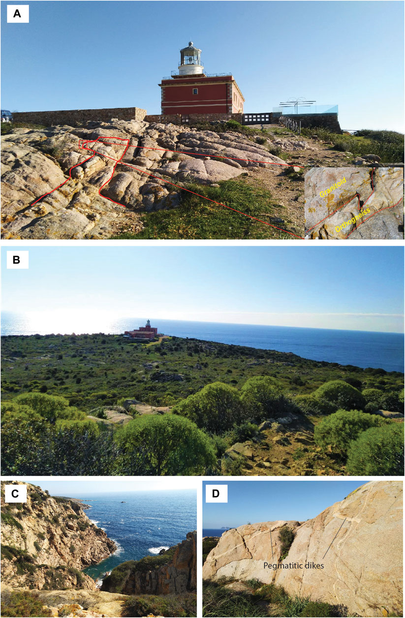
FIGURE 6. (A) View of the lighthouse in the background and, in front, the Monte Filau orthogneiss intruded by Variscan granitoids; (B) view of the lighthouse and Capo Spartivento from the road that leads to Mt. Sa Guardia Manna; (C) high, sub-vertical, incised cliffs, few dozen meters south of the lighthouse; (D) granitoid body, about 100 m north-west of the lighthouse, with centimeter-thick pegmatites.
A wide panorama of the southern Sardinian coast, spanning from Cala Cipolla to the east, to Capo Teulada to the west, can be observed from the top of these cliffs. An even wider panorama, that reaches the eastern edge of the Cagliari Gulf, can be admired from the top of the Mt. Sa Guardia Manna, few minutes northward by feet, which represents the highest point of this sector (Figure 6B). The cliffs have subvertical to vertical surfaces (Figure 6C) and are cut by decametre-wide embayment, locally hosting caves and small gravel beaches. The seawater deep blue indicates that the cliffs continue several meters below the sea level.
The geology and geomorphology of this stretch of coast are mainly dominated by a granitoid pluton that covers an area of about 4.5 km2 around the cape and that, at first sight, seems to be the only outcropping rock. A careful examination reveals the presence of orthogneiss bodies belonging to the Monte Filau Orthogneiss enclosed within granites and well exposed at about 20 m to the west of the lighthouse (Figure 6A and inset). Granites are characterized by pinkish to greyish colour, medium to coarse grain size and a massive texture lacking any foliation or preferential orientation (Figure 6D). Orthogneiss are similar in colour but shows a finer grain size and an evident foliation mainly marked by phyllosilicates, and a weak mineral lineation lying on the foliation plane. The contact between these two rocks is sharp and devoid of any reaction border (Figure 6A).
The lighthouse itself represents a tourist attraction. It was built in 1856 by Navy and represents one of the ancient lighthouses still currently working. The structure is a two-storey building surmounted by the lighthouse tower that reaches 81 m above the sea level. A barrack, that formerly hosted a small garrison, stands close to the lighthouse. Both buildings were totally renovated few years ago and now are a Luxury Guests Houses.
Stop 5. Tuerredda beach (Figure 7). This beach, an enclave of the Teulada’s municipality within Domus de Maria territory, is one of the most renowned beaches of the southern Sardinia. It is located approximately half-way between Chia and Capo Malfatano, at the end of a small, north-south oriented, alluvial valley between Mt. Pranedda (east) and a headland called “Schiena del Siciliano” (west). The Tuerredda beach is set in a highly valuable naturalistic context, being surrounded by several square kilometres of almost uninhabited land covered by Mediterranean forest and scrub (Figure 7A). Moreover, the area behind the poorly developed dunes, is partly occupied by a small transient pond and it can be regarded as a wetland (“Tuerredda” in Sardinian language means “small wetland”). From a geological point of view, the alluvial valley is set along a fault that separates two different geological formations and affects the local geomorphology: To the east, the soundness of the rocks belonging to the Monte Filau Orthogneiss is reflected in the steep hill of Mt. Pranedda; the “softer” rocks of the Bithia Unit (to the west) result in the Schiena del Siciliano gentle and rounded low hill. The difference between the two formations is evident in the Tuerredda beach even for laypersons; on the left, looking toward the sea, the yellowish to greyish, coarse-grained orthogneiss crops out as a compact rock fractured at right-angled sharp edges (Figure 7B). The straight foliation is marked by dark elongated trails of biotite crystals. On the opposite side of the beach, the rocks belonging to the Bithia Unit are well exposed (Figure 7C). They consist of dark brown/grey foliated rocks hosting several centimetre-sized folded veins and lenses of quartz. It is worth of note the strong deformation affecting these rocks that can be recognized by the pervasive foliation and by folds of different styles and geometries. The same lithological contrast can be observed in the Tuerredda islet, a small (about 4 hectares) islet emerging from the sea at about 200 m from the shoreline.
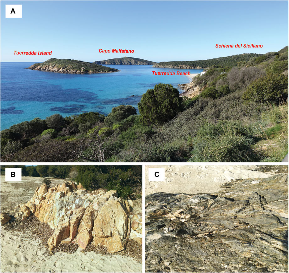
FIGURE 7. (A) View from the main road (toward SW) of the Tuerredda beach and island in the foreground and Capo Malfatano and Schiena del Siciliano headlands in the background; (B) outcrop of the Monte Filau orthogneiss in the eastern side of the Tuerredda beach; (C) outcrop of the highly deformed Bithia Unit phyllites in the western side of the Tuerredda beach.
Stop 6. Capo Malfatano cape (Figure 8). It is a hilly promontory that juts southward into the sea for about 1.5 km and delimiting the western side of a bay hosting the Tuerredda beach and other small sandy to pebbly coves. Similarly, to the stop 1, this stage of the itinerary offers different kinds of attractions, including landscape, history, and geology. The former is the more evident at first sight since Capo Malfatano is surrounded by coves, headlands, cliffs, and a wide lagoon overlooking the crystal-clear seawater in a context of pristine nature (Figure 8A). From the geomorphological point of view, the lagoon is a ria that is a deep coastal inlet formed by the drowning of a river valley. The valley formed during Messinian age (7–5 Ma) when the sea level was lower and the coastline was retreated, and then was submerged and covered by sediments during a sea level rise. The subsequent sea-level fluctuations led to the erosion of the younger sediments and finally to a new drowning of the ria that led to the present lagoon formation (Orrù et al., 2014).
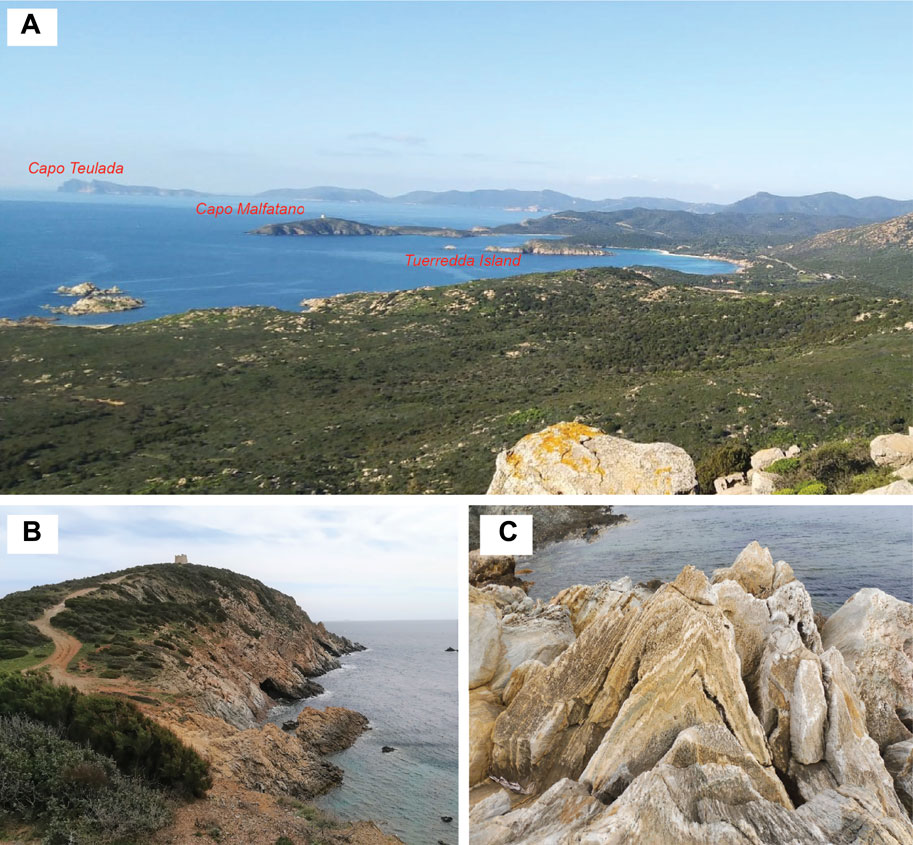
FIGURE 8. (A) View (toward SW) from Mt. Sa Guardia Manna (stop 4) of the Capo Malfatano promontory and the Tuerredda island in the foreground; in the background can be recognized the Capo Teulada promontory; (B) view of the Capo Malfatano tower looking toward south, with the phyllites of the Bithia Unit outcropping in the cliffs; (C) E-W striking upright fold in marbles from the south-east side of the Capo Malfatano promontory.
Less known but worth to be mentioned and valorised is the history of this site. Thanks to its position and geomorphology it represented a strategic site since Phoenician age; the deep inlet on the east side was a natural safe harbour, the inner lagoon was (and still is) a fish-farm and the promontory itself was an ideal lookout point. Unfortunately, few remains of the older occupation stages have been found; Phoenician presence is testified by few ceramics remains but, considering the lack of infrastructures (buildings, routes, harbour), Capo Malfatano was likely a temporary shelter during storm events, rather than a stable inhabited site (Bartoloni, 2009). More documented, even if badly preserved, are the evidence of the Roman civilization stage, testified by several roman sites scattered in the whole area (Giuman and Ibba, 2012): a partially submerged ancient Villa resting on the lagoon coast that was also used for fish-processing by salting; a small roman necropolis in an inlet on the eastern coast that was unearthed after a storm; the remains of a quarry that was exploited to obtain sandstone ashlars; a totally submerged structure formed by metre-sized squared blocks. The latter was an ancient breakwater/bulwark of undefined age, spanning from Phoenician to late-Roman period (Antonioli et al., 2007, and references therein) now lying 1.3 m below the sea level. Orrù et al. (2014) hypothesized that the structure, now partly collapsed by waves, was formerly at least 1 m above the sea level and thus, coupled with other geological and archaeological evidence, determined a sea level rise of about 2 m in the last 2,400 years. Thanks to the low depth, the structure can be explored even by inexpert divers. The more recent history of Capo Malfatano is documented by the homonym Spanish tower resting on the southern edge of the promontory at about 65 m a.s.l (Figure 8B). It was built at the end of 16th century (1593 is the first attestation) as a military post equipped with heavy artillery and during its three century-long life was involved in different attacks by barbary pirates.
The geology of this area is dominated by the rocks of the Bithia Unit that in this zone can be found in three different facies (Pavanetto et al., 2012; Cruciani et al., 2018). The most widespread facies consists of greyish to brownish laminated metasandstones/quartzites and phyllites with alternating darker and lighter levels. In the south-eastern edge of the promontory a hectometre-long marble body, likely representing a formerly limestone layer within the siliciclastic sequence, crops out as a NE-SW elongated lens, sometimes showing beautiful, E-W striking upright folds (Figure 8C). On the opposite side of the promontory, in a little bay in the western side, a metavolcanic layer within the same stratigraphic sequence can be found. In addition, a decametre-long NW-SE oriented lens of yellowish to pinkish albitite crops out in the central area of the cape (Cruciani et al., 2019a). In the south-eastern sector of the promontory, phyllites often show a strong mylonitic deformation with asymmetric folds and various kinematic indicator; these rocks can therefore be treated as mylonites.
All the above-described rocks belong to the Variscan basement that is locally covered by Quaternary loose to consolidated deposits.
Stop 7. Piscinnì site. As well as in the previous stop, here it can be observed a territory that offers more than a touristic attraction for beachgoers. Indeed, the Piscinnì beach, characterized by fine-grained pearl-grey colour beaches and shallow turquoise water, is just the starting point of a historical and archaeological trip along this stretch of coast. Moving from the beach toward south-east, there is an almost continuous rocky outcrop that reaches Capo Malfatano cape, locally interrupted by few metres-wide inlets and coves. The main lithology is represented by Upper Pleistocene (120–80 ka) sandstones lying in direct contact over the Palaeozoic basement, here represented by the Bithia Unit, thus marking a gap of more than 450 Ma (Figure 9E). Pleistocene sediments form a 3–5 m thick sequence that, from the bottom, consist of a transgressive conglomeratic basal level, followed by marine fossiliferous sandstone and finally by aeolian sandstones showing well preserved cross laminations. These sandstones are carbonate-cemented and commonly show good mechanical properties but, at the same time, are not too hard to be cut and carved; for these reasons, they represented a good construction material largely used in local Punic and Roman settlements. Several remains of ancient quarries are scattered along a 1.5 km-long stretch of coast. Some of the quarries are so well preserved that is still possible to observe the quarry faces and floors (Figures 9A–C), and it can be appreciated the huge volume of the exploited material. The scaling, the niches left by ashlars removing, the marks of the utensil used by quarrymen are still evident on the rocky faces.
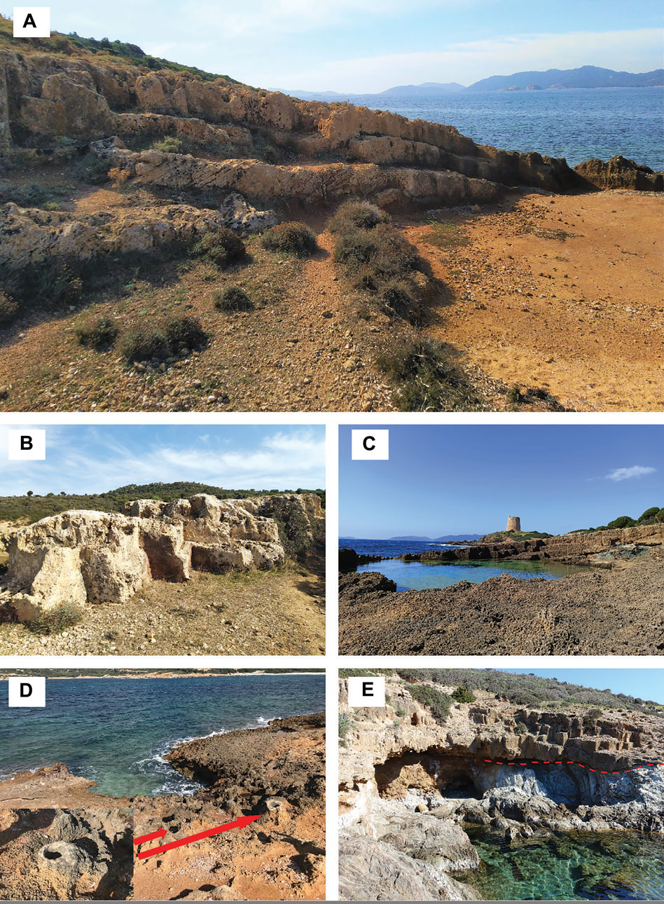
FIGURE 9. (A,B) Sandstone quarries close to the Piscinnì beach; (C) sandstone quarry on the south-east side of the Piscinnì promontory where the homonym Spanish tower rests; (D) holes into the rocky substrate likely carved to wedge in wooden poles supporting a crane; (E) cantilever terraces excavated into the sandstone above the metamorphic basement.
Accumulation of centimetre-sized sandstone fragments, deriving from the ashlars squaring-off, are locally found at the edge of the quarries. Some metre-sized squared indentations along the coastline show an unnaturally regular shape, suggesting that they were intentionally cut into the rocks to make easy the docking and the load/unload operations by ships (Figure 9C). This hypothesis is supported by the finding, behind one of these indentations, of three decimetric circular holes distanced about 3.5 m one from the other that were likely the housing of poles supporting a crane (Figure 9D and inset). The huge volume of the materials removed from the quarries, estimated at about 150.000 m3 (Orrù et al., 2014), the quarry organization and design, the former presence of cranes and/or other earth-moving equipment (Figure 9D) indicate that this area was a full-fledged extractive industrial complex, rather than a small business. Moving further toward south the promontory of Piscinnì can be reached. A Spanish tower, less or more coeval to that of Capo Malfatano cape, stands above the promontory (Figure 9C). It was built for defensive purposes using mainly sandstone ashlars from a nearby ancient quarry and/or reusing ashlars from an older (Roman?) and larger structure whose shape and dimension can be recognized by the remains of its perimetral walls.
In the studied area, the dominant lithologies are part of the Palaeozoic crystalline basement, mainly represented by metamorphic rocks (Bithia Unit, Settiballas Schists and Monte Filau orthogneiss) and igneous rocks (late Variscan granitoids) (Figure 1B). Subordinated Quaternary sediments crop out in the western sector (Figure 1D).
The Bithia Unit mainly consists of metasandstones, metapelites and locally quartzites, with marbles and metavolcanics intercalations, the latter dated at about 460 Ma, Middle Ordovician (Pavanetto et al., 2012; Cruciani et al., 2018). It is visible in various coastal outcrops especially in stop 1 (Chia tower), stop 6 (Capo Malfatano promontory) and stop 7 (Piscinnì bay) (Figure 1B). In stop 1 the Bithia Unit is represented by well foliated and folded metapelites, metadolostone and marbles whose contact can be seen in the outcrops under the Chia tower (Figure 3B). The highest lithological variability of the Bithia Unit is expressed in stop 6 (Figure 8), where metavolcanics, metasandstones, metapelites, marbles and quartzites crop out. Layered marbles are intercalated with metapelites in the south-east side of the promontory (Figure 8C), whereas poorly foliated metavolcanics and metasandstones crop out in a narrow bay in the western side. In stop 7, the Bithia Unit is composed exclusively by metapelites with thin arenaceous intercalations well exposed in the almost continuous road cuts of the SP71 route (Figure 1D) and along the coast where form a didactic unconformity with the overlying Quaternary sandstones (stop 7, Figure 9). The main foliation with associated lineation can be well recognized. Quartz veins following the foliation and folds are abundant.
The tectonic contact between the Bithia Unit and the older Nebida Group is approximately located in the Piscinnì lagoon (Pavanetto et al., 2012) and is covered by recent deposits. The Nebida Group can be seen in the western side of the Piscinnì bay along the road cuts (Figure 1B); in this area it is composed by metapelites and metalimestones still preserving fossiliferous content and depositional structures.
In thin section the metapelites consist of an intercalation of moderately deformed quartz + plagioclase layers (Figure 10A), and micaceous layers formed by muscovite and chlorite crystals oriented along the main foliation. Marbles are composed of calcite and quartz with rare muscovite flakes and dolomite crystals (Figures 10C,D). Metavolcanics are made up by a fine-grained matrix of quartz and oriented micas wrapping sub-millimetric K-feldspar porphyroclasts probably representing volcanic relicts rotated by a shear deformation.
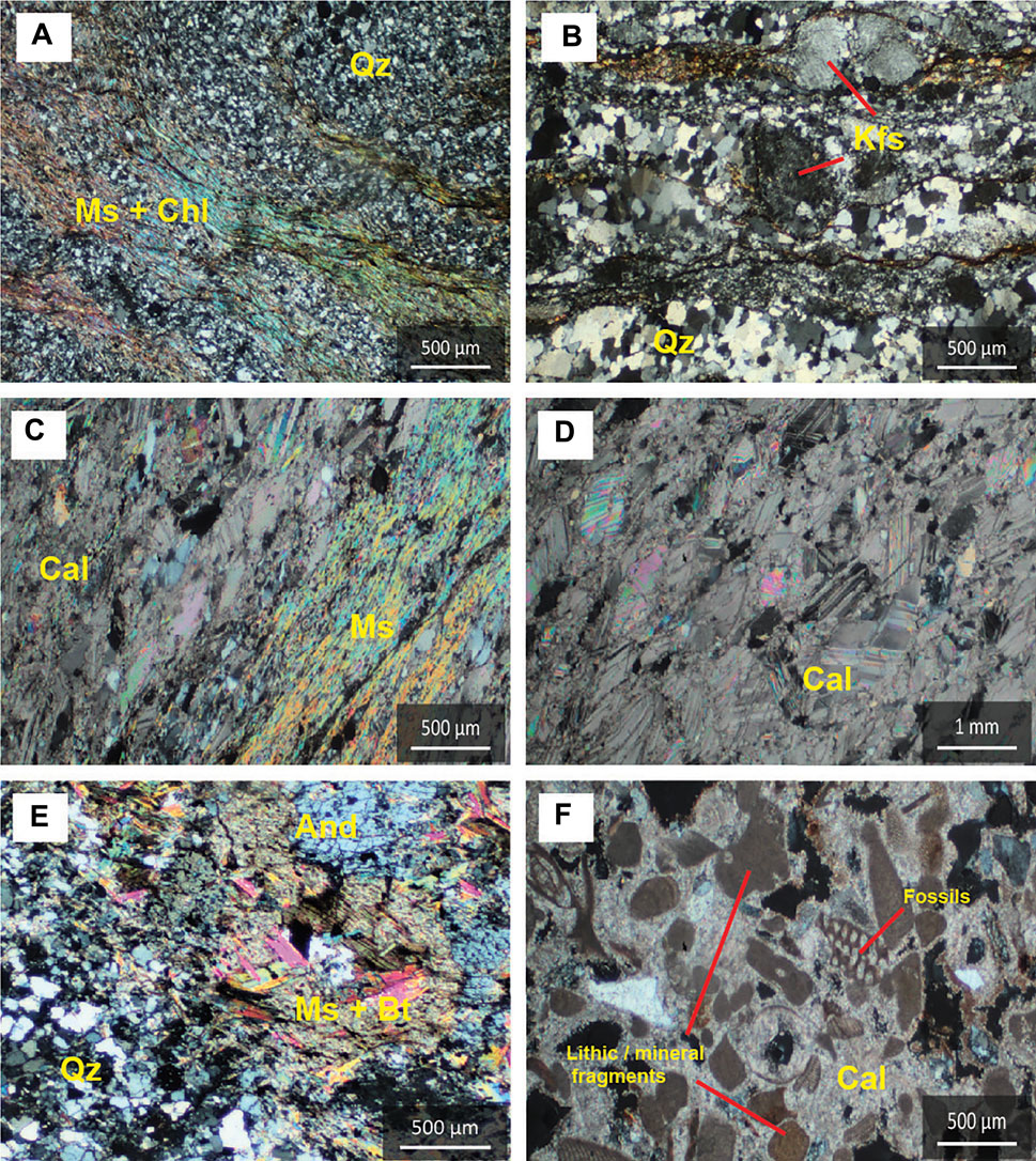
FIGURE 10. Petrographic features of metamorphic and sedimentary rocks described in the itinerary. (A) Layering in a metapelite from the Bithia Unit, with quartz-feldspar layers and muscovite-chlorite layers that mark the main foliation; (B) sample of the Monte Filau orthogneiss from stop 3 showing a rotated K-feldspar porphyroblast in a K-feldspar+quartz matrix, with phyllosilicates marking the foliation; (C) marble from stop 1, with muscovite flakes that mark the foliation and the matrix of calcite crystals; (D) marble from stop 6 with a lesser amount of muscovite and a higher amount of calcite with respect to (C); (E) sample from stop 3 of the Settiballas Schists, with a layer composed of andalusite + muscovite + biotite in contact with a quartz-feldspatic layer; (F) sample from stop 7 of the quaternary sandstones, with the carbonate matrix which includes lithic clasts, quartz crystals, and fossils.
The Monte Filau Orthogneiss and the Settiballas Schists crop out in the central sector of the proposed itinerary, in stop 2 (Su Giudeu - Porto Campana), stop 3 (Chia Laguna Resort) and stop 4 (Capo Spartivento). The best exposure of the two metamorphic rocks, including their contact, can be seen in the road cuts within the Chia Laguna Resort and in the overlooking hill. The Settiballas Schists (Figures 2, 5) consist of metapelites and metasandstones of unknown age showing petrographic features of both contact and regional metamorphism. Contact metamorphism is revealed by mm-sized, rounded andalusite crystals, better visible in outcrops close to the orthogneiss, likely formed during the emplacement of the Middle Ordovician granite, the protolith of the Monte Filau orthogneiss (Pavanetto et al., 2012). At the thin section scale, andalusite is associated with biotite and muscovite and intercalated with quartz- and feldspars-rich layers (Fig. 10E).
The Monte Filau orthogneiss occurs in three different facies: a biotite-rich one, and two leucocratic (biotite-poor) ones further distinguished in a fine-grained and a coarse-grained facies (Cruciani et al., 2019b). The coarse-grained leucocratic facies is composed of quartz, feldspars, muscovite and rare biotite. The fine-grained facies hosts also garnet, sillimanite, andalusite and coarse-grained muscovite; moreover, at the outcrop scale, mm-thick dark aggregates are observed (Mazzoli and Visonà, 1992). The biotite facies is composed by mm-thick quartz-feldspatic porphyroblasts wrapped by biotite crystals marking the main schistosity (Figure 10B).
The igneous rocks are represented by Upper Carboniferous – Lower Permian granitoids extensively cropping out between Su Giudeu and Teurredda and represented by greyish to pink equigranular granodiorites with variably sized biotite crystals and subordinated leucogranites. Quartz veins, aplitic clusters with porphyritic texture, and mafic enclaves are common. The widest outcrop is in the Capo Spartivento and Mt. Sa Guardia Manna areas (Stop 4, Figure 6) where it intrudes the Monte Filau Orthogneiss here represented by elongated apophyses of the biotite-rich facies. A smaller but interesting and didactic outcrop can be observed in the Su Giudeu islet (stop 2, Figure 4), where granitoids intrudes and envelops the strongly deformed Settiballas Schists and, in turn, both are crosscut by aplite dikes. The granitoids have a simple mineralogy consisting of quartz, K-feldspar + plagioclase and biotite and are cut by cm-thick pegmatite veins, aplite dikes and mafic enclaves.
Quaternary sandstones are scattered in the Capo Malfatano promontory and in the Piscinnì area, where they reach the widest extension. They consist of sandstones, micro-conglomerates and minor conglomerates with carbonate cement, belonging to different depositional environments, from shoreface to dune environment. In the Piscinnì area (stop 7) sedimentary structures as cross-stratification and abrasion surfaces are clearly visible. These deposits are particularly interesting due to their exploitation in Phoenician-Roman times, as proved by the remains of the quarries. In thin section, sandstones are characterized by quartz and feldspar grains derived from the erosion of previous crystalline rocks, and scattered fossils such as gastropods, foraminifera, and bivalves (Figure 10F) surrounded by a carbonate matrix.
More recent deposits are widespread behind the coastal line of Su Giudeu–Porto Campana and in the Piscinnì areas, as lagoon deposits which characterize the typical landscapes of the whole area, well visible during dry periods as wide plains of pelitic-muddy and organic sediments; associated with them there are large sandy beach and dune system, whose features reflect the actual erosional, transport and sedimentation processes.
The raw data supporting the conclusion of this article will be made available by the authors, without undue reservation.
SC wrote the first draft of the manuscript. SC, DF, and LD contributed to conception and design of the study. GC and MF organized the database and wrote sections of the manuscript. DF performed quantitative assessment of the new proposal geosite. All authors contributed to manuscript revision, read, and approved the submitted version.
This research was funded by the PON-AIM Project “Attraction and International Mobility” (Rif. AIM1890410—3, D.D. n. 407 del 27.02.2018) of MIUR and also supported by Regione Autonoma della Sardegna, L.R. 7/2007, research programme “Il blocco Sardo–Corso: area chiave per la ricostruzione della geodinamica varisica” CUP J81G17000110002.
The authors are grateful to Prof. K. Nemeth and to two reviewers for their constructive criticisms that greatly improved the manuscript.
The authors declare that the research was conducted in the absence of any commercial or financial relationships that could be construed as a potential conflict of interest.
All claims expressed in this article are solely those of the authors and do not necessarily represent those of their affiliated organizations or those of the publisher, the editors, and the reviewers. Any product that may be evaluated in this article or claim that may be made by its manufacturer is not guaranteed or endorsed by the publisher.
1https://www1.finanze.gov.it/finanze/analisi_stat/public/index.php?tree=2021#download_dataset.
Alexandrowicz, Z. (1998). Representative Geosites of Poland and Their Status of Conservation. Geol. Balc. 28, 37–42.
Antonioli, F., Anzidei, M., Lambeck, K., Auriemma, R., Gaddi, D., Furlani, S., et al. (2007). Sea-level Change during the Holocene in Sardinia and in the Northeastern Adriatic (Central Mediterranean Sea) from Archaeological and Geomorphological Data. Quat. Sci. Rev. 26, 2463–2486. doi:10.1016/J.QUASCIREV.2007.06.022
Balletto, G., Milesi, A., Ladu, M., and Borruso, G. (2020). A Dashboard for Supporting Slow Tourism in Green Infrastructures. A Methodological Proposal in Sardinia (Italy). Sustainability 202012, 3579. doi:10.3390/SU12093579
Bartoloni, P. (2009). I FENICI E I CARTAGINESI in Sardegna. Sassari: Carlo Delfino Editore. Available at: https://www.academia.edu/29693172/I_FENICI_E_I_CARTAGINESI_in_Sardegna (Accessed February 16, 2022).
Bartoloni, P. (1996). La necropoli di Bithia - I. Roma: Istituto per la civiltà Fenicia e Punica - CNR.
Bartoloni, P. (2000). La necropoli di Monte Sirai - I. Roma: Istituto per la civiltà Fenicia e Punica - CNR.
Benedetto, G., Madau, F. A., Carzedda, M., Marangon, F., and Troiano, S. (2022). Social Economic Benefits of an Underground Heritage: Measuring Willingness to Pay for Karst Caves in Italy. Geoheritage 14 (2), 69–13. doi:10.1007/S12371-022-00701-Z
Bertorino, G., Franceschelli, M., Luglie, C., Marchi, M., and Columbu, S. (2002). Petrographic Characterisation of Polished Stone Axes from Neolithic Sardinia: Archaeological Implications. Period. Mineral. 71, 87–100.
Brilha, J., Gray, M., Pereira, D. I., and Pereira, P. (2018). Geodiversity: an Integrative Review as a Contribution to the Sustainable Management of the Whole of Nature. Environ. Sci. Policy 86, 19–28. doi:10.1016/j.envsci.2018.05.001
Brilha, J. (2016). Inventory and Quantitative Assessment of Geosites and Geodiversity Sites: a Review. Geoheritage 8, 119–134. doi:10.1007/S12371-014-0139-3
Brocx, M., and Semeniuk, V. (2007). Geoheritage and Geoconservation-History, Definition, Scope and Scale. J. R. Soc. West Aust. 90, 53–87.
Bruschi, V. M., Cendrero, A., and Albertos, J. A. C. (2011). A Statistical Approach to the Validation and Optimisation of Geoheritage Assessment Procedures. Geoheritage 3, 131–149. doi:10.1007/s12371-011-0038-9
Buosi, C., Columbu, S., Ennas, G., Pittau, P., and Scanu, G. G. (2019a). Mineralogical, Petrographic, and Physical Investigations on Fossiliferous Middle Jurassic Sandstones from Central Sardinia (Italy) to Define Their Alteration and Experimental Consolidation. Geoheritage 11, 729–749. doi:10.1007/s12371-018-0326-8
Buosi, C., Porta, M., Trogu, D., Casti, M., Ferraro, F., de Muro, S., et al. (2019b). Data on Coastal Dunes Vulnerability of Eleven Microtidal Wave-Dominated Beaches of Sardinia (Italy, Western Mediterranean). Data Brief 24, 103897. doi:10.1016/j.dib.2019.103897
Cabras, S., de Waele, J., and Sanna, L. (2008). Caves and Karst Aquifer Drainage of Supramonte (Sardinia, Italy): A Review. Acta Carsologica 37. doi:10.3986/ac.v37i2.148
Carmignani, L., Oggiano, G., Barca, S., Conti, P., Eltrudis, A., Funedda, A., et al. (2001). “Note Illustrative Della Carta Geologica Della Sardegna in Scala 1: 200.000,” in Memorie Descrittive Della Carta Geologica d’Italia (Rome, Italy: Istituto Poligrafico e Zecca dello Stato).
Ciccarelli, D., Pinna, M. S., Alquini, F., Cogoni, D., Ruocco, M., Bacchetta, G., et al. (2017). Development of a Coastal Dune Vulnerability Index for Mediterranean Ecosystems: A Useful Tool for Coastal Managers? Estuar. Coast. Shelf Sci. 187, 84–95. doi:10.1016/J.ECSS.2016.12.008
Cocco, F., Oggiano, G., Funedda, A., Loi, A., and Casini, L. (2018). Stratigraphic, Magmatic and Structural Features of Ordovician Tectonics in Sardinia (Italy): a Review. J. Iber. Geol. 44, 619–639. doi:10.1007/s41513-018-0075-1
Columbu, S., Antonelli, F., and Sitzia, F. (2018). Origin of Roman Worked Stones from St. Saturno Christian Basilica (South Sardinia, Italy). Mediterr. Archaeol. Archaeom. 18, 17–36. doi:10.5281/zenodo.1256047
Columbu, S., Garau, A. M., and Lugliè, C. (2019). Geochemical Characterisation of Pozzolanic Obsidian Glasses Used in the Ancient Mortars of Nora Roman Theatre (Sardinia, Italy): Provenance of Raw Materials and Historical–Archaeological Implications. Archaeol. Anthropol. Sci. 11, 2121–2150. doi:10.1007/S12520-018-0658-Y
Columbu, S., and Garau, A. M. (2017). Mineralogical, Petrographic and Chemical Analysis of Geomaterials Used in the Mortars of Roman Nora Theatre (South Sardinia, Italy). Italian J. Geosciences 136, 238–262. doi:10.3301/IJG.2017.05
Columbu, S., Gaviano, E., Costamagna, L. G., and Fancello, D. (2021). Mineralogical-petrographic and Physical-Mechanical Features of the Construction Stones in Punic and Roman Temples of Antas (SW Sardinia, italy): Provenance of the Raw Materials and Conservation State. Minerals 11, 964. doi:10.3390/min11090964
Columbu, S., Lisci, C., Sitzia, F., and Buccellato, G. (2017). Physical–mechanical Consolidation and Protection of Miocenic Limestone Used on Mediterranean Historical Monuments: the Case Study of Pietra Cantone (Southern Sardinia, Italy). Environ. Earth Sci. 76, 148–229. doi:10.1007/S12665-017-6455-6
Columbu, S. (2018). Petrographic and Geochemical Investigations on the Volcanic Rocks Used in the Punic-Roman Archaeological Site of Nora (Sardinia, Italy). Environ. Earth Sci. 77, 577–619. doi:10.1007/s12665-018-7744-4
Columbu, S., Usai, M., Rispoli, C., and Fancello, D. (2022). Lime and Cement Plasters from 20th Century Buildings: Raw Materials and Relations between Mineralogical–Petrographic Characteristics and Chemical–Physical Compatibility with the Limestone Substrate. Minerals 12, 226. doi:10.3390/min12020226
Costa, M., Etzi, F., Falqui, P., and Pitzalis, A. (2014). “Esperienze e risultati degli interventi di recupero e salvaguardia dei sistemi dunari di villasimius e Chia nella Sardegna meridionale,” in Proceedings of Fifth International Symposium Monitoring of Mediterranean coastal areas: problems and measurement techniques, Livorno, June 17–19, 2014 (Florence, Italy: CNR-IBIMET), 171–180.
Costamagna, L. G., Elter, F. M., Gaggero, L., and Mantovani, F. (2016). Contact Metamorphism in Middle Ordovician Arc Rocks (SW Sardinia, Italy): New Paleogeographic Constraints. Lithos 264, 577–593. doi:10.1016/J.LITHOS.2016.09.014
Crofts, R. (2014). Promoting Geodiversity: Learning Lessons from Biodiversity. Proc. Geologists'. Assoc. 125, 263–266. doi:10.1016/J.PGEOLA.2014.03.002
Cruciani, G., Fancello, D., Franceschelli, M., and Musumeci, G. (2019b). Geochemistry of the Monte Filau Orthogneiss (SW Sardinia, Italy): Insight into the Geodynamic Setting of Ordovician Felsic Magmatism in the N/NE Gondwana Margin. Italian J. Geosciences 138, 1–18. doi:10.3301/IJG.2018.32
Cruciani, G., Fancello, D., Franceschelli, M., and Musumeci, G. (2017). The Paleozoic Basement of Monte Grighini Unit, a Deep View in the Nappe Structure of Variscan Belt in Sardinia. Synthesis of Geological Data and Field Guide. Atti della Soc. Toscana Sci. Nat. Mem. Ser. A 124. doi:10.2424/ASTSN.M.2017.19
Cruciani, G., Fancello, D., and Franceschelli, M. (2019a). Occurrence of Albitite from Capo Malfatano, SW Sardinia: Frst Report, Characterization from Mineralogy and Whole-Rock Geochemistry. Period. Mineral. 88. doi:10.2451/2019PM830
Cruciani, G., Franceschelli, M., Caredda, A. M., and Carcangiu, G. (2001). Anatexis in the Hercynian Basement of NE Sardinia, Italy: A Case Study of the Migmatite of Porto Ottiolu. Mineral. Petrol. 71, 195–223. doi:10.1007/s007100170039
Cruciani, G., Franceschelli, M., Elter, F. M., Puxeddu, M., and Utzeri, D. (2008a). Petrogenesis of Al-Silicate-Bearing Trondhjemitic Migmatites from NE Sardinia, Italy. Lithos 102, 554–574. doi:10.1016/j.lithos.2007.07.023
Cruciani, G., Franceschelli, M., Foley, S. F., and Jacob, D. E. (2014). Anatectic Amphibole and Restitic Garnet in Variscan Migmatite from NE Sardinia, Italy: Insights into Partial Melting from Mineral Trace Elements. Eur. J. Mineral. 26, 381–395. doi:10.1127/0935-1221/2014/0026-2376
Cruciani, G., Franceschelli, M., Groppo, C., and Spano, M. E. (2012). Metamorphic evolution of non-equilibrated granulitized eclogite from Punta de li Tulchi (Variscan Sardinia) determined through texturally controlled thermodynamic modelling. J. Metamorph. Geol. 30, 667–685. doi:10.1111/j.1525-1314.2012.00993.x
Cruciani, G., Franceschelli, M., Jung, S., Puxeddu, M., and Utzeri, D. (2008b). Amphibole-bearing Migmatites from the Variscan Belt of NE Sardinia, Italy: Partial Melting of Mid-ordovician Igneous Sources. Lithos 105, 208–224. doi:10.1016/J.LITHOS.2008.03.009
Cruciani, G., Franceschelli, M., Massonne, H. J., Musumeci, G., and Spano, M. E. (2016). Thermomechanical Evolution of the High-Grade Core in the Nappe Zone of Variscan Sardinia, Italy: The Role of Shear Deformation and Granite Emplacement. J. Metamorph. Geol. 34, 321–342. doi:10.1111/jmg.12183
Cruciani, G., Franceschelli, M., Puxeddu, M., and Tiepolo, M. (2018). Metavolcanics from Capo Malfatano, SW Sardinia, Italy: New Insight on the Age and Nature of Ordovician Volcanism in the Variscan Foreland Zone. Geol. J. 53, 1573–1585. doi:10.1002/gj.2976
Cruciani, G., Montomoli, C., Carosi, R., Franceschelli, M., and Puxeddu, M. (2015). Continental Collision from Two Perspectives: A Review of Variscan Metamorphism and Deformation in Northern Sardinia. Period. Mineral. 84. doi:10.2451/2015PM0455
dos Santos, F. M., de La Corte Bacci, D., Saad, A. R., and da Silva Ferreira, A. T. (2020). Geodiversity Index Weighted by Multivariate Statistical Analysis. Appl. Geomat. 12, 361–370. doi:10.1007/s12518-020-00303-w
Ellis, N. (2011). The Geological Conservation Review (GCR) in Great Britain—Rationale and Methods. Proc. Geologists'. Assoc. 122, 353–362. doi:10.1016/J.PGEOLA.2011.03.008
Fancello, D., Cruciani, G., Franceschelli, M., and Massonne, H.-J. (2018). Trondhjemitic Leucosomes in Paragneisses from NE Sardinia: Geochemistry and P-T Conditions of Melting and Crystallization. Lithos 304-307, 501–517. doi:10.1016/j.lithos.2018.02.023
Fassoulas, C., Mouriki, D., Dimitriou-Nikolakis, P., and Iliopoulos, G. (2012). Quantitative Assessment of Geotopes as an Effective Tool for Geoheritage Management. Geoheritage 4, 177–193. doi:10.1007/s12371-011-0046-9
Ferrarini, A., Celada, C., and Gustin, M. (2021). Preserving the Mediterranean Bird Flyways: Assessment and Prioritization of 38 Main Wetlands under Human and Climate Threats in Sardinia and Sicily (Italy). Sci. Total Environ. 751, 141556. doi:10.1016/J.SCITOTENV.2020.141556
Franceschelli, M., Battaglia, S., Cruciani, G., Pasci, S., and Puxeddu, M. (2017). Very Low-Temperature Metamorphism in Ordovician Metasedimentary Rocks above and below the Sardic Unconformity, SW Sardinia, Italy. Int. J. Earth Sci. 106, 531–548. doi:10.1007/s00531-016-1370-8
Franceschelli, M., Columbu, S., Elter, F. M., and Cruciani, G. (2021). Giant Garnet Crystals in Wollastonite–Grossularite–Diopside-Bearing Marbles from Tamarispa (NE Sardinia, Italy): Geosite Potential, Conservation, and Evaluation as Part of a Regional Environmental Resource. Geoheritage 13, 96–11. doi:10.1007/S12371-021-00622-3
Fuertes-Gutiérrez, I., and Fernández-Martínez, E. (2012). Mapping geosites for geoheritage management: A methodological proposal for the regional park of picos de europa (León, Spain). Environ. Manag. 50, 789–806. doi:10.1007/S00267-012-9915-5
Gioncada, A., Pitzalis, E., Cioni, R., Fulignati, P., Lezzerini, M., Mundula, F., et al. (2019). The Volcanic and Mining Geoheritage of San Pietro Island (Sulcis, Sardinia, Italy): the Potential for Geosite Valorization. Geoheritage 11, 1567–1581. doi:10.1007/S12371-019-00418-6
Giuman, M., and Ibba, M. A. (2012). Indagini Archeologiche a Capo Malfatano (Teulada): Prime Acquisizioni. L’Africa Romana 19, 2936–2943.
Gordon, J. E., Crofts, R., and Díaz-Martínez, E. (2018). “Geoheritage Conservation and Environmental Policies: Retrospect and Prospect,” in Geoheritage: Assessment, Protection, and Management (Amsterdam, Netherlands: Elsevier), 213–235. doi:10.1016/B978-0-12-809531-7.00012-5
Gordon, J. E. (2018). Geoheritage, Geotourism and the Cultural Landscape: Enhancing the Visitor Experience and Promoting Geoconservation. Geosciences 8, 136. doi:10.3390/GEOSCIENCES8040136
Gray, M. (2013). Geodiversity : Valuing and Conserving Abiotic Nature. New jersey, United States: Wiley-Blackwell. Available at: https://www.wiley.com/en-us/Geodiversity%3A+Valuing+and+Conserving+Abiotic+Nature%2C+2nd+Edition-p-9780470742150 (Accessed February 13, 2022).
Gray, M. (2008). Geodiversity: Developing the Paradigm. Proc. Geologists'. Assoc. 119, 287–298. doi:10.1016/S0016-7878(08)80307-0
Gray, M. (2011). Other Nature: Geodiversity and Geosystem Services. Environ. Conserv. 38, 271–274. doi:10.1017/S0376892911000117
Gray, M. (2018). The Confused Position of the Geosciences within the “Natural Capital” and “Ecosystem Services” Approaches. Ecosyst. Serv. 34, 106–112. doi:10.1016/J.ECOSER.2018.10.010
Hose, T. A. (2008). Towards a History of Geotourism: Definitions, Antecedents and the Future, London: Geological Society Special Publication, 37–60. doi:10.1144/SP300.5
Ibáez, J. J., Brevik, E. C., and Cerdà, A. (2019). Geodiversity and Geoheritage: Detecting Scientific and Geographic Biases and Gaps through a Bibliometric Study. Sci. Total Environ. 659, 1032–1044. doi:10.1016/J.SCITOTENV.2018.12.443
Junker, B., and Schneider, H.-H. (1983). The Infracambrian Bithia Formation - its Facies Development in Southwest Sardinia. njgpm. 6, 369–384. doi:10.1127/njgpm/1983/1983/369
Kirchner, K. (2016). “The Dyje Canyon-like Valley: Geomorphological Landscape of Deep Valley at the Eastern Part of the Marginal Slope of Bohemian Massif,” in Landscapes and Landforms of the Czech Republic. Editors T. Pánek, and J. Hradecký (Cham: Springer), 233–247. doi:10.1007/978-3-319-27537-6_19
Kirillova, K., Fu, X., Lehto, X., and Cai, L. (2014). What Makes a Destination Beautiful? Dimensions of Tourist Aesthetic Judgment. Tour. Manag. 42, 282–293. doi:10.1016/j.tourman.2013.12.006
Kubalíková, L. (2019). Assessing Geotourism Resources on a Local Level: A Case Study from Southern Moravia (Czech Republic). Resources 8, 150. doi:10.3390/RESOURCES8030150
Kubalíková, L. (2014). Geomorphosite Assessment for Geotourism Purposes. Czech J. Tour. 2, 80–104. doi:10.2478/CJOT-2013-0005
Massonne, H. J., Cruciani, G., and Franceschelli, M. (2013). Geothermobarometry on Anatectic Melts-A High-Pressure Variscan Migmatite from Northeast Sardinia. Int. Geol. Rev. 55, 1490–1505. doi:10.1080/00206814.2013.780720
Mazzoli, C., and Visonà, D. (1992). “The Gneisses of Monte Filau (Capo Spartivento, SW Sardinia): Petrographic and Chemical Features,” in Contributions to the Geology of Italy with Special Regard to the Paleozoic Basements. IGCP 276, Newsletter. Editors L. Carmignani, and F. P. Sassi, 175–182.
Mehdioui, S., El Hadi, H., Tahiri, A., El Haibi, H., Tahiri, M., Zoraa, N., et al. (2022). The Geoheritage of Northwestern Central Morocco Area: Inventory and Quantitative Assessment of Geosites for Geoconservation, Geotourism, Geopark Purpose and the Support of Sustainable Development. Geoheritage 14 (3), 86–26. doi:10.1007/S12371-022-00712-W
Migoń, P., and Pijet-Migoń, E. (2017). Viewpoint Geosites — Values, Conservation and Management Issues. Proc. Geologists'. Assoc. 128, 511–522. doi:10.1016/J.PGEOLA.2017.05.007
Migoń, P., Różycka, M., and Michniewicz, A. (2018). Conservation and Geotourism Perspectives at Granite Geoheritage Sites of Waldviertel, Austria. Geoheritage 10, 11–21. doi:10.1007/S12371-017-0219-2
Migoń, P., and Różycka, M. (2021). When Individual Geosites Matter Less—Challenges to Communicate Landscape Evolution of a Complex Morphostructure (Orlické–Bystrzyckie Mountains Block, Czechia/Poland, Central Europe). Geoscience 11, 100. doi:10.3390/GEOSCIENCES11020100
Mikhailenko, A. v., Nazarenko, O. v., Ruban, D. A., and Zayats, P. P. (2017). Aesthetics-based Classification of Geological Structures in Outcrops for Geotourism Purposes: a Tentative Proposal. Geologos 23, 45–52. doi:10.1515/logos-2017-0004
Mikhailenko, A. v., Ruban, D. A., and Ermolaev, V. A. (2021). Accessibility of Geoheritage Sites—A Methodological Proposal. Heritage 4, 1080–1091. doi:10.3390/HERITAGE4030060
Mikhailenko, A. v., and Ruban, D. A. (2019). Geo-heritage Specific Visibility as an Important Parameter in Geo-Tourism Resource Evaluation. Geosci. (Basel) 9, 146. doi:10.3390/geosciences9040146
Moroni, A., Gnezdilova, V. v., and Ruban, D. A. (2015). Geological Heritage in Archaeological Sites: Case Examples from Italy and Russia. Proc. Geologists'. Assoc. 126, 244–251. doi:10.1016/J.PGEOLA.2015.01.005
Mossa, A., Camùnez, J. A., and Morandi, F. (2018). Current State of the First Unesco Global Geopark: A Case Study of the Geological and Mining Park of Sardinia. Geoj. Tour. Geosites 22 (2), 403–418. doi:10.30892/gtg.22211-29
Mucivuna, V. C., Reynard, E., Garcia, M., and da, G. M. (2019). Geomorphosites Assessment Methods: Comparative Analysis and Typology. Geoheritage 11, 1799–1815. doi:10.1007/S12371-019-00394-X
Németh, B., Németh, K., Procter, J. N., and Farrelly, T. (2021b). Geoheritage Conservation: Systematic Mapping Study for Conceptual Synthesis. Geoheritage 13, 45–21. doi:10.1007/S12371-021-00561-Z
Németh, B., Németh, K., and Procter, J. N. (2021a). Informed Geoheritage Conservation: Determinant Analysis Based on Bibliometric and Sustainability Indicators Using Ordination Techniques. Land 10, 539. doi:10.3390/LAND10050539
Nerem, R. S., Beckley, B. D., Fasullo, J. T., Hamlington, B. D., Masters, D., and Mitchum, G. T. (2018). Climate-change–driven Accelerated Sea-Level Rise Detected in the Altimeter Era. Proc. Natl. Acad. Sci. U. S. A. 115, 2022–2025. doi:10.1073/PNAS.1717312115
Newsome, D., and Dowling, R. (2018). “Geoheritage and geotourism,” in Geoheritage: Assessment, protection, and management. Editors E. Reynard, and J. Brilha (Amsterdam: Elsevier), 305–321. doi:10.1016/B978-0-12-809531-7.00017-4
Oggiano, G., Gaggero, L., Funedda, A., Buzzi, L., and Tiepolo, M. (2010). Multiple Early Paleozoic Volcanic Events at the Northern Gondwana Margin: U-Pb Age Evidence from the Southern Variscan Branch (Sardinia, Italy). Gondwana Res. 17, 44–58. doi:10.1016/j.gr.2009.06.001
Orrù, P. E., Mastronuzzi, G., Deiana, G., Pignatelli, C., Piscitelli, A., Solinas, E., et al. (2014). Sea Level Changes and Geoarchaeology between the Bay of Capo Malfatano and Piscinnì Bay (SW Sardinia) in the Last 4 Kys. Quat. Int. 336, 180–189. doi:10.1016/j.quaint.2014.03.054
Panizza, M. (2009). The Geomorphodiversity of the Dolomites (Italy): A Key of Geoheritage Assessment. Geoheritage 1, 33–42. doi:10.1007/s12371-009-0003-z
Pavanetto, P., Funedda, A., Northrup, C. J., Schmitz, M., Crowley, J., and Loi, A. (2012). Structure and U-Pb Zircon Geochronology in the Variscan Foreland of SW Sardinia. Geol. J. 47 (4), 426–445. doi:10.1002/gj.1350
Pereira, L. S., de Carvalho, D. M., and da Cunha, L. S. (2019). Methodology for the Semi-quantitative Evaluation of Geoheritage Applied to Coastal Geotourism in João Pessoa (Paraíba, Northest Brazil). Geoheritage 11, 1941–1953. doi:10.1007/S12371-019-00417-7
Pereira, P., Pereira, D., and Caetano Alves, M. I. (2007). Geomorphosite Assessment in Montesinho Natural Park (Portugal). Geogr. Helv. 62, 159–168. doi:10.5194/GH-62-159-2007
Perra, C. (2009). “Nuovi elementi per la tipologia degli insediamenti fenici della Sardegna Sud-Occidentale,” in Phönizisches und punisches Städtewesenn, Akten der internationalen Tagung. Editors S. Helas, and D. Marzoli (Roma: Iberia Archeologica), 13, 351–366.
Picchi, S. (2008). MANAGEMENT of Natura 2000 Habitats. 2250 *Coastal Dunes with Juniperus Spp. Directive 92/43/EEC on the conservation of natural habitats and of wild fauna and flora. Technical Report 2008 06/24.
Pillola, G. L., Leone, F., and Loi, A. (1995). “The Lower Cambrian Nebida Group of Sardinia,” in 6th Paleobenthos International Symposium, Guide-Book. Cagliari: Rendiconti del Seminario della Facoltà di Scienze dell’Università di Cagliari). Editor A. Cherchi.
Pinna, M. S., Bacchetta, G., Cogoni, D., and Fenu, G. (2019). Is Vegetation an Indicator for Evaluating the Impact of Tourism on the Conservation Status of Mediterranean Coastal Dunes? Sci. Total Environ. 674, 255–263. doi:10.1016/J.SCITOTENV.2019.04.120
Pompianu, E. (2010). Sulky Fenicia (Sarde Gna): Nuove Ricerche Nell’abitato. Fasti Online Documents Res. 212, 1–18.
Pralong, J.-P. (2005). A Method for Assessing Tourist Potential and Use of Geomorphological Sites. geomorphologie 11, 189–196. doi:10.4000/GEOMORPHOLOGIE.350
Pralong, J. P., and Reynard, E. (2005). A Proposal for the Classification of Geomorphological Sites Depending on Their Tourist Value. Quaternario 18, 315–321.
Prosser, C. D. (2018). Geoconservation, Quarrying and Mining: Opportunities and Challenges Illustrated through Working in Partnership with the Mineral Extraction Industry in England. Geoheritage 10, 259–270. doi:10.1007/s12371-016-0206-z
Prosser, C., Murphy, M., and Larwood, J. (2006). “Geological Conservation: A Guide to Good Practice,” English Nature. Peterborough, UK, 145.
Reimann, L., Vafeidis, A. T., Brown, S., Hinkel, J., and Tol, R. S. J. (2018). Mediterranean UNESCO World Heritage at Risk from Coastal Flooding and Erosion Due to Sea-Level Rise. Nat. Commun. 9, 1–11. doi:10.1038/s41467-018-06645-9
Reynard, E., and Brilha, J. (2017). in Geoheritage: Assessment, Protection, and Management. Editors E. Reynard, and J. Brilha (Netherland: Elsevier).
Reynard, E., Fontana, G., Kozlik, L., and Scapozza, C. (2007). A Method for Assessing "scientific" and "additional Values" of Geomorphosites. Geogr. Helv. 62, 148–158. doi:10.5194/gh-62-148-2007
Rossi, P., and Cocherie, A. (1991). Genesis of a Variscan Batholith: Field, Petrological and Mineralogical Evidence from the Corsica-Sardinia Batholith. Tectonophysics 195, 319–346. doi:10.1016/0040-1951(91)90219-I
Ruban, D. A., Mikhailenko, A. v., and Yashalova, N. N. (2022). Valuable Geoheritage Resources: Potential versus Exploitation. Resour. Policy 77, 102665. doi:10.1016/J.RESOURPOL.2022.102665
Ruban, D. A. (2010). Quantification of Geodiversity and its Loss. Proc. Geologists'. Assoc. 121, 326–333. doi:10.1016/j.pgeola.2010.07.002
Ruban, D. A., Sallam, E. S., Khater, T. M., and Ermolaev, V. A. (2021). Golden Triangle Geosites: Preliminary Geoheritage Assessment in a Geologically Rich Area of Eastern Egypt. Geoheritage 13, 54–15. doi:10.1007/S12371-021-00582-8
Rybar, P. (2010). Assessment of Attractiveness (Value) of Geotouristic Objects. Acta Geoturistica 1, 13–21.
Štrba, L., Rybár, P., Baláž, B., Molokáč, M., Hvizdák, L., Kršák, B., et al. (2015). Geosite Assessments: Comparison of Methods and Results. Curr. Issues Tour. 18, 496–510. doi:10.1080/13683500.2014.882885
Strba, S., and Rybar, P. (2015). Revision of the “Assessment of Attractiveness (Value) of Geotouristic Objects. Acta Geoturistica 6, 30–40.
Štrba, Ľ. (2019). Analysis of Criteria Affecting Geosite Visits by General Public: a Case of Slovak (Geo)Tourists. Geoheritage 11, 291–300. doi:10.1007/S12371-018-0283-2
Sumanapala, D., Kubalíková, L., and Wolf, I. D. (2021). Assessing Geosites for Geotourism Development: Case Studies from the Southern Part of Sri Lanka. Geoheritage 13, 85–11. doi:10.1007/S12371-021-00608-1
van Ree, C. C. D. F., and van Beukering, P. J. H. (2016). Geosystem Services: A Concept in Support of Sustainable Development of the Subsurface. Ecosyst. Serv. 20, 30–36. doi:10.1016/J.ECOSER.2016.06.004
Verdiani, G., and Columbu, S. (2010). “E.Stone, an archive for the sardinia monumental witnesses,” inDigital heritage. Editors M. Ioannides, D. Fellner, A. Georgopoulos, and D. G. Hadjimitsis (Berlin: Springer) Vol. 6436, 356–372. doi:10.1007/978-3-642-16873-4_27
Vujičić, M. D., Vasiljević, D. A., Hose, T. A., Tasić, N., Morar, C., Durić, A., et al. (2018a). A Multi-Criteria Decision Analysis with Special Reference to Loess and Archaeological Sites in Serbia (Could Geosciences and Archaeology Cohabitate?). Open Geosci. 10, 333–343. doi:10.1515/GEO-2018-0026
Vujičić, M. D., Vasiljević, D. A., Marković, S. B., Hose, T. A., Lukić, T., Hadžić, O., et al. (2011). Preliminary Geosite Assessment Model (GAM) and its Application on Fruška Gora Mountain, Potential Geotourism Destination of Serbia. Acta Geogr. Slov. 51, 361–376. doi:10.3986/AGS51303
Vukoičić, D., Milosavljević, S., Valjarević, A., Nikolić, M., and Srećković-Batocánin, D. (2018b). The Evaluation of Geosites in the Territory of National Park “Kopaonik” (Serbia). Open Geosci. 10, 618–633. doi:10.1515/GEO-2018-0049
Widawski, K., Oleśniewicz, P., Rozenkiewicz, A., Zareba, A., and Jandová, S. (2020). Protected Areas: Geotourist Attractiveness for Weekend Tourists Based on the Example of Gorcza Nski National Park in Poland. Resources 9, 35. doi:10.3390/RESOURCES9040035
Wimbledon, W., Benton, M., Bevins, R., Black, G., Bridgland, D., Cleal, C., et al. (1995). The Development of a Methodology for the Selection of British Geological Sites for Conservation. Part 1. Mod. Geol. 20, 159–202.
Wrede, V., and Mügge-Bartolović, V. (2012). GeoRoute Ruhr-A Network of Geotrails in the Ruhr Area National GeoPark, Germany. Geoheritage 4, 109–114. doi:10.1007/S12371-012-0057-1
Zakharovskyi, V., and Németh, K. (2021). Quantitative-qualitative Method for Quick Assessment of Geodiversity. Land (Basel) 10, 946. doi:10.3390/LAND10090946
Keywords: geoheritage, geoconservation, archaeology, Punic-Roman quarry, touristic and educational value, geotrail
Citation: Fancello D, Columbu S, Cruciani G, Dulcetta L and Franceschelli M (2022) Geological and archaeological heritage in the Mediterranean coasts: Proposal and quantitative assessment of new geosites in SW Sardinia (Italy). Front. Earth Sci. 10:910990. doi: 10.3389/feart.2022.910990
Received: 01 April 2022; Accepted: 29 July 2022;
Published: 05 October 2022.
Edited by:
Maria Da Glória Garcia, University of São Paulo, BrazilReviewed by:
Dmitry Ruban, Southern Federal University, RussiaCopyright © 2022 Fancello, Columbu, Cruciani, Dulcetta and Franceschelli. This is an open-access article distributed under the terms of the Creative Commons Attribution License (CC BY). The use, distribution or reproduction in other forums is permitted, provided the original author(s) and the copyright owner(s) are credited and that the original publication in this journal is cited, in accordance with accepted academic practice. No use, distribution or reproduction is permitted which does not comply with these terms.
*Correspondence: S. Columbu, Y29sdW1idXNAdW5pY2EuaXQ=
Disclaimer: All claims expressed in this article are solely those of the authors and do not necessarily represent those of their affiliated organizations, or those of the publisher, the editors and the reviewers. Any product that may be evaluated in this article or claim that may be made by its manufacturer is not guaranteed or endorsed by the publisher.
Research integrity at Frontiers
Learn more about the work of our research integrity team to safeguard the quality of each article we publish.