Corrigendum: Stratigraphic-tectonic evolution and characterization of the carboniferous in the Karamay-Baikouquan fault zone in the Northwestern Margin of the Junggar Basin, Northwest China
 Yinshan Ma
 Tao Wang1*
- 1Chinese Academy of Geological Sciences, Beijing, China
- 2School of Earth Resources, China University of Geosciences, Wuhan, China
- 3Xinjiang Oilfield Company, Xinjiang, China
The northwestern margin of the Junggar Basin has a complex tectonic history, which is challenging for hydrocarbon exploration. This study highlights the structural patterns, tectonic evolution, and controlling factors of the Karamay–Baikouquan Fault Zone (KBFZ) in the northwestern margin of the Junggar Basin based on well-log and 3D seismic data. The main findings of this study include the following: spatially, we have divided the structural patterns of KBFZ into three zones on the plane, namely, northern, central, and southern zones; temporarily, the tectonic evolution has been divided into five stages from Late Carboniferous to Cretaceous, namely, Early-Middle Carboniferous, Late Carboniferous-Early Permian, Middle-Late Permian, Triassic-Middle Jurassic, and Late Jurassic-Cretaceous. During the Hercynian and Indochina orogeny, the compressional stress from the movement of the Dalabute strike-slip fault and the Genghis–Junggar strike-slip fault produced various degrees of deformation in different locations in the KBFZ. The general structural style is a mixture of strike-slip and thrust-nappe. The main controlling factors include stress period, stress direction, and stratigraphic-lithologic associations. This study has implications for hydrocarbon exploration and development in the northwestern margin of the Junggar Basin.
Introduction
The Junggar Basin is situated in the western part of the Central Asian Orogenic Belt (CAOB), the largest accretionary orogenic belt in the world (Şengör et al., 1993; Hu et al., 2000; Jahn et al., 2004; Xiao and Kusky, 2009). As an important part of the Central Asian Mountain Belt, the Junggar Basin has also experienced complex structural evolution, such as the subduction of oceanic plates, accretion of epicontinental crust, and intracontinental transformation (Windley et al., 2007; Xiao et al., 2019). Specifically, the particularity of the northwestern margin of the Junggar Basin lies in that it has been subjected to the superimposed component force generated by the Dalabute strike-slip fault zone and the Genghis–Junggar fault zone since the Late Paleozoic, which had an important impact on the tectonic patterns and evolution of the study area. Thirteen oil and gas fields have been discovered in the multi-phased Karamay–Baikouquan Fault Zone (KBFZ) on the northwestern margin of the Junggar Basin (Sui, 2015). However, the complex structural patterns and tectonic history of the KBFZ imposed challenges on further breakthroughs in oil and gas exploration in the Carboniferous.
Recognizing the structural patterns of the fault zone is essential to oil and gas exploration in the northwestern margin of the Junggar Basin. The previous understanding of the structural patterns in the study area can be summarized in three categories as follows:
a) Thrust-nappe as the predominant structural style: this pattern is based on the overthrust zone developed from the Late Paleozoic to Early Mesozoic (He et al., 2004; Kuang and Qi, 2006) and basement-involved high-angle thrust fault zone (Yang et al., 2011) as indicated by seismic and geologic data.
b) Strike-slip as the predominant structural style: this pattern is based on the strike-slip fault system around the Junggar Basin, including the Wu–Xia Fault Zone, KBFZ, and Hong–Che Fault Zone, based on seismic, magnetotelluric, and outcrop data (Zhu et al., 2021). The mechanism of the origin is still in debate. One interpretation is that the strike-slip system is a converging right-lateral system controlled by the Dalabute Fault and formed under right-lateral transpression (Shao et al., 2011; Zhang et al., 2011). Another interpretation of the origin of the strike-slip system is that it was the result of compression and inversion rather than the orogeny or Dalabute Fault (Chen S. et al., 2016).
c) Mixture characteristics of overthrust and transpression: this pattern is based on overthrusting of the Lower Paleozoic strata onto the Permian strata in the early stage of the basin under E-W compression, whereas the overthrust evolved into flower structures due to right-lateral strike-slip movement under the control of the Dalabute Fault in the late stage. Overall, the structural pattern is not a typical overthrust nor a typical converging strike-slip fault but a mixture of both (Zhang et al., 2011; Li et al., 2018).
The northwestern margin of the Junggar Basin exhibits both strike-slip and overthrust systems. The strike-slip system converges with the Dalabute Fault and shows right-lateral movement associated with an en-echelon array of folds. The overthrusting of Lower Paleozoic strata onto Permian strata is supported by drilling, well-log, seismic, and time-frequency electric data (Guo et al., 2015). In addition, physical modeling suggests that high-angle reverse fault can form in compressional stress (Xiong et al., 2017).
The Junggar Basin has evolved into a superposed basin since the Permian. The fundamental difference between the shallow and deep petroleum systems is the structural superposition and evolution in the deep part of the basin (Pang, 2010). The focus of this study is the detailed structural patterns of the KBFZ in the northwestern margin using the latest 2D and 3D seismic data. This study aims to summarize the structural patterns, evolution, and main controlling factors of the KBFZ. This study has implications for the structural geology of the northwestern margin of the Junggar Basin and hydrocarbon exploration and development in the deep basin.
Geologic Setting
The study area is the Karamay–Baikouquan Fault Zone (KBFZ), located in the northern part of Xinjiang Uygur Autonomous Region in northwestern China. The KBFZ is situated in the middle section of the northwestern margin of the Junggar Basin and trends NE-SW. It bounds the Hong–Che Fault Zone to the south, Wu–Xia Fault Zone to the north, Mahu Depression to the east, and Zaire Mountain–Hala'alate Mountain to the west, adjacent to the Dalatube Fault to the northwest (Figure 1).
Figure 1
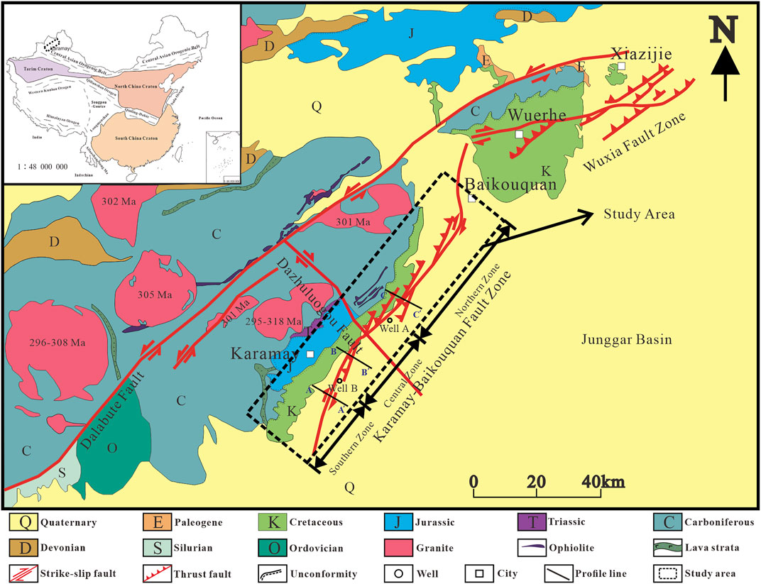
Figure 1. The geological sketch map of the Karamay–Baikouquan Fault Zone and adjacent area (modified after Zhao and Guo, 2012; Chen X. et al., 2016).
The study area has developed sedimentary strata from the Late Paleozoic, and the drilling on the footwall has encountered Carboniferous, Permian, Triassic, Jurassic, and Cretaceous strata in ascending order. The focus of this study is the Carboniferous. The Carboniferous in the footwall must have great burial depth because the deepest well in the study area only encountered the Permian Jiamuhe Formation at a maximum depth of 5,300 m, as indicated by Baiyang-1 Well. The overthrusting Permian strata include the Jiamuhe Formation, Fengcheng Formation, Xiazijie Formation, Lower Wuerhe Formation, and Upper Wuerhe Formation. The Jiamuhe Formation and Fengcheng Formation are two source rocks for potential gas fields in the study area (Li et al., 2018). The Carboniferous strata in the hanging wall mainly consist of volcanic and pyroclastic rocks, as well as some sedimentary and metamorphic rocks (Jin et al., 2018).
The West Junggar Area is a tectonic unit adjacent to the northwestern margin of the Junggar Basin. Its tectonic evolution has a profound impact on the northwestern margin of the Junggar Basin. The West Junggar Area is separated from the Balkhash by the Genghis–Junggar Fault, which is a Mesozoic right-lateral strike-slip fault (Chen et al., 2015). There are many large-scale left-lateral strike-slip faults in the West Junggar Area, exposing Carboniferous strata, multiple granitic plutons, and ophiolite (Chen and Jahn, 2004; Chen and Arakawa, 2005; Windley et al., 2007; Zhou et al., 2008; Geng et al., 2009; Chen et al., 2015). Among these faults, the Dalabute strike-slip fault is the major fault in the northwestern margin of Junggar Basin (Fan et al., 2014), and the general trend is NE-SW. The Dalabute Fault connects with the Karamaili Fault in the northeast and Zhaluleshan-Laba Fault in the southwest, the three of which form an arc of 360 km in length (Chen et al., 2015). The Dalabute Fault can be divided into three zones along the strike based on structural patterns: southern, central, and northern zones. The southern zone extends from north of Suyek to Burkestai and is characterized by strike-slip with transpression. The central zone extends from Burkestai to Baiyanghe and is characterized by reverse faults on the south and normal faults on the north. The northern zone is the north side of the Hala Alat Mountain and is characterized by thrusting and folding (Sun et al., 2008). These characteristics suggest a multi-phase tectonic history. The Dalabute Fault was initiated in the Late Carboniferous (Zhang et al., 1989); the left-lateral strike-slip began in Permian; the thrusting and folding began in the Triassic along with the orogeny; the left-lateral transpression began in the Jurassic (Sun et al., 2008); and the normal faults and down-thrown of the northwestern block began in the Cenozoic (Feng et al., 1990; Sun et al., 2008; Chen et al., 2015).
Geophysical explorations, including gravity, magnetic, and electrical, began in the early 1950s in the Junggar Basin. Since the 1990s, 3D seismic data have covered most of the northwestern margin of the basin. Many oil fields have been discovered since 1955, including the Karamay and Baikouquan oil fields. The Carboniferous overthrust and the Permian underthrust are the prospecting targets for future exploration (Chen et al., 2020).
The dataset of this study comprises well-log data and 2D and 3D seismic data. The data source used in this study was acquired by the Xinjiang Oilfield Company. The total length of 2D seismic lines is 230 km, and the total area of the six 3D seismic datasets used exceeds 5,000 km2. The quality of the seismic data has been improved through reprocessing. The seismic horizons were calibrated using synthetic seismic. The regional stratigraphic framework was established by combining seismic and well-log datasets. Collectively, the stratigraphic and lithological characteristics and structural relationships were analyzed.
Structural Patterns
The KBFZ exhibits combined characteristics of thrust-nappe and strike-slip systems on cross-sections. Specifically, the derived faults of the Dalabute Fault are mainly imbricate thrust-nappe, and deep strike-slip faults are developed in the deep Carboniferous. Structural patterns vary from south to north due to different local controlling factors. The KBFZ is divided into three zones based on fault characteristics, degree of deformation, and lithology, namely, northern, central, and southern zones, respectively (Figure 1). The nearest well near the boundary of the zone is selected as the zone boundary.
The northern zone extends from Well A to the northern boundary of the KBZB. There are two mid-high angle thrust faults trending NW-SE at a depth of 2,500 m, and the Carboniferous strata were overthrust onto the Permian strata and became a nappe (Figure 2). The hanging wall nappe has a higher degree of deformation and lower volcanic content. The underthrust consists of primarily Permian strata that show some brittle deformation. The strata at the footwall span from Carboniferous to Cretaceous with a lower degree of deformation and greater thickness. The competence of the strata appears to decrease downward. Overall, the strata dip toward the basin center with the influence of the KBFZ.
Figure 2
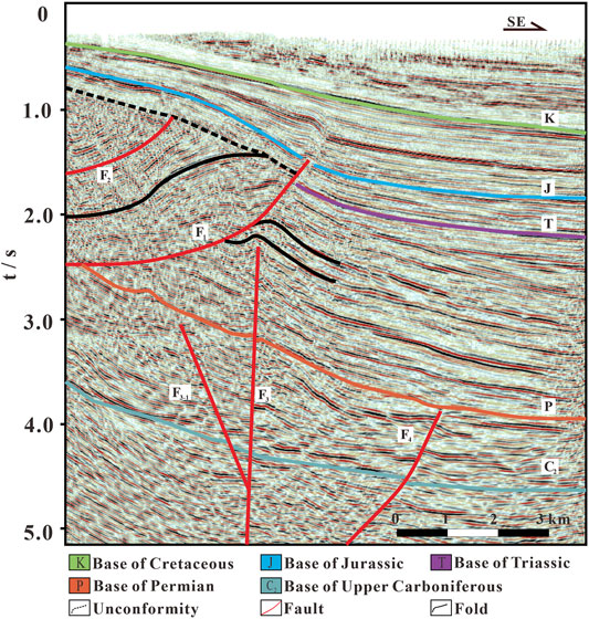
Figure 2. Seismic profile of the northern zone of the Karamay–Baikouquan Fault Zone.
The central zone extends from Well B to Well A. In the upper part, the thrust faults form an imbricated structure. These faults partially cut through the Jurassic, but rarely the Cretaceous and the dips of the faults increase upward (Figure 3). In the lower part, there are multiple deep strike-slip faults, the growth of which might have been influenced by the overthrust. The combinations of some of the deep faults appear to be flower structures. The faults and associated faults within the Carboniferous strata are densely packed. Compared to the northern zone, there is a higher volcanic content and lower degree of folding in the hanging wall and a lower thickness in the Permian in the footwall.
Figure 3
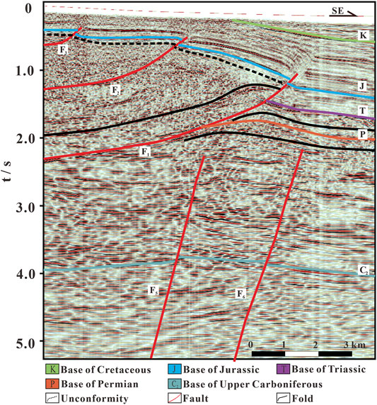
Figure 3. Seismic profile of the central zone of the Karamay–Baikouquan Fault Zone.
The southern zone extends from Well B to the southern boundary of the KBFZ. The structural style is similar to that of the central zone, with thrust faults in the hanging wall and deep strike-slip faults in the footwall (Figure 4). The seismic facies is more chaotic and less continuous. In the hanging wall, the Permian is mostly missing and the Triassic is localized and much thinner than that in the footwall. These are characteristics of growth faults (Xiong et al., 2017). In the footwall, the Carboniferous strata are primarily volcanic rocks, and the Permian is overthrust above Triassic. As a result, the Permian is often missing in the southern zone. In the footwall, there is an increase in the thickness of the Triassic and younger strata.
Figure 4
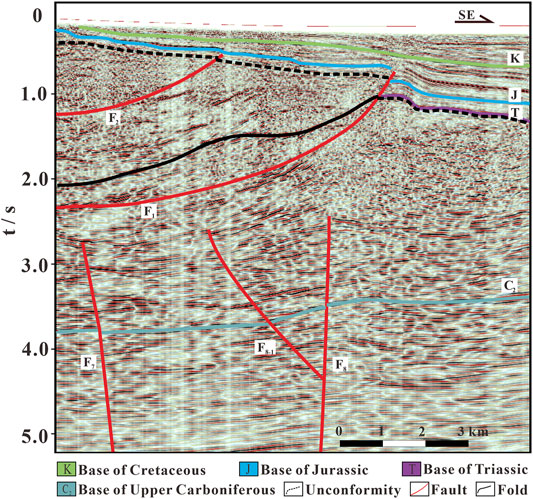
Figure 4. Seismic profile of the southern zone of the Karamay–Baikouquan Fault Zone.
Discussion
Tectonic Evolution
To improve the understanding of the tectonic history of the KBFZ, we have divided it into five stages since the Carboniferous (Figures 5, 6):
Figure 5
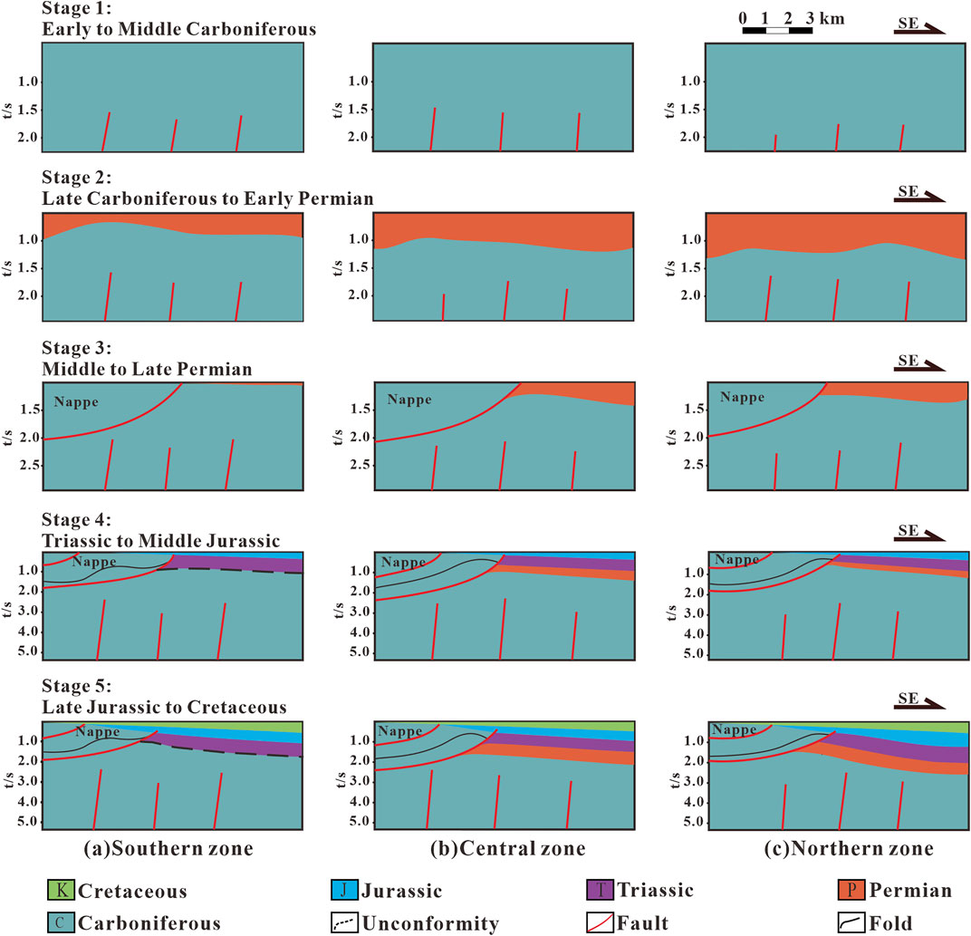
Figure 5. Comparison of tectonic evolution processes in different areas of the Karamay–Baikouquan Fault Zone from Late Carboniferous to Cretaceous.
Figure 6
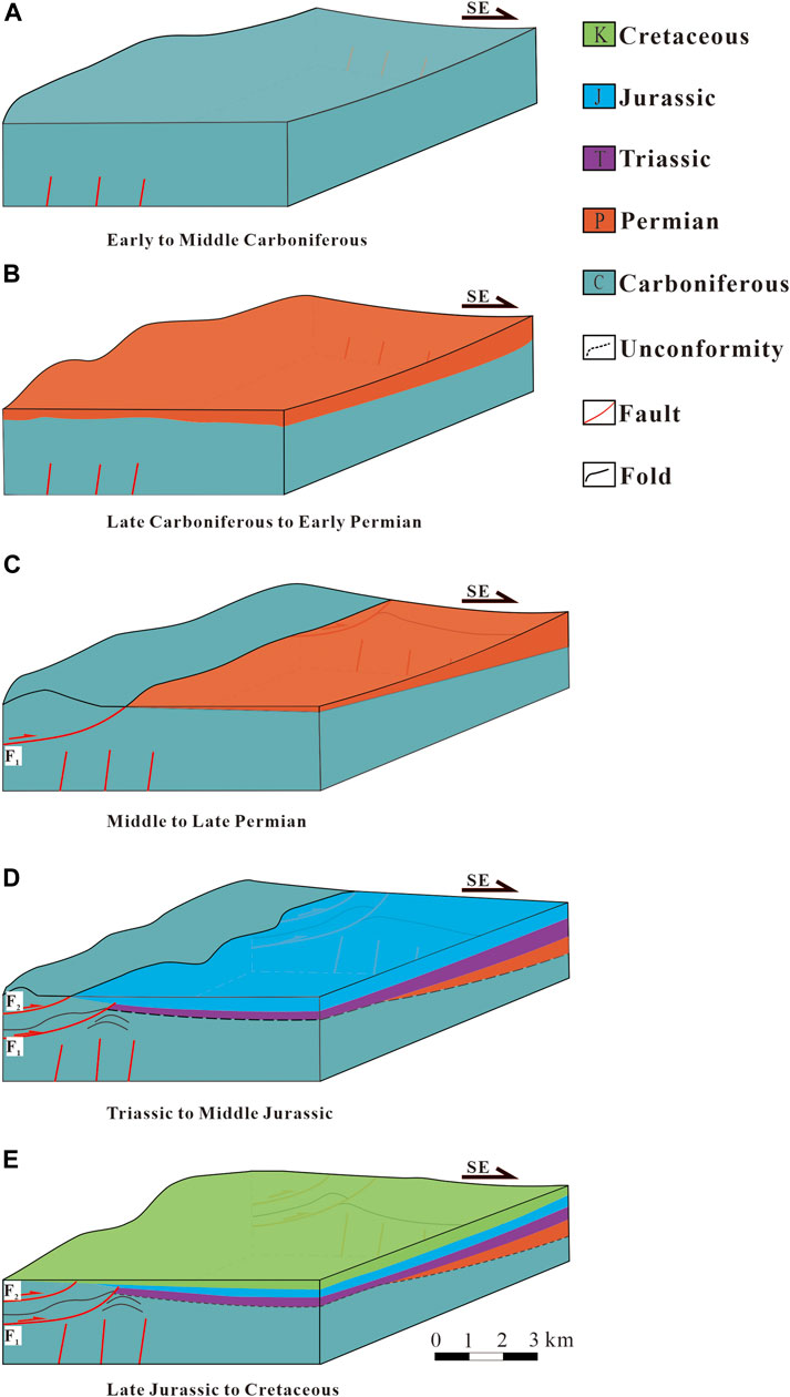
Figure 6. Three-dimensional tectonic evolution of the Karamay–Baikouquan Fault Zone from Late Carboniferous to Cretaceous. (A) Stage 1: Early to Middle Carboniferous; (B), Stage 2: Late Carboniferous to Early Permian; (C), Stage 3: Middle to Late Permian; (D), Stage 4: Triassic to Middle Jurassic; (E), Stage 5: Late Jurassic to Cretaceous.
Stage 1: Early to Middle Carboniferous. Many original strike-slip faults developed in the West Junggar Oceanic Basin. These faults played an important role in tectonic evolution. The tectonic history of the northwestern margin is influenced by plate movements during the Paleozoic. In the Late Paleozoic, the Paleo-Asian Ocean had mainly disappeared, and only residual oceanic basins developed in the Balkhash Lake-West Junggar area (Xu et al., 2010). During Carboniferous, synchronously with the Hercynian orogeny, subduction-accretion occurred between the western Junggar oceanic crust and the Kazakhstan plate (Tang et al., 2010).
Stage 2: Late Carboniferous to Early Permian. This is a transitional stage. The study area transitioned into intracontinental evolution, and the entire Junggar Basin began to develop. The West Junggar oceanic basin had closed, and the Kazakhstan-Junggar Plate had merged with the Siberian Plate and the Tarim Plate. This area had completed the ocean-continent transition (Shi et al., 2017) from oceanic plate subduction (possibly mid-ocean ridge subduction) to the intracontinental environment and entered a new stage of basin evolution (Yang et al., 1992; Cheng and Wang, 1998; Shi et al., 2017). Then, the study area began to uplift and developed landforms (Zhang et al., 2021). During the Early Permian, the study area experienced intracratonic extension and crustal thinning (Sui, 2015), resulting in intensive magmatic intrusion (Chen S. et al., 2016). It is likely that the magma followed the faults and formed some positive volcanic landscapes, which may have modified the depositional environments. At the same time, the Dalubute Fault was formed and exhibited left-lateral strike-slip movement.
Stage 3: Middle to Late Permian. During this stage, the compressive stress had increased significantly, and the activation of the Dalabute Fault had imposed different structural styles in the upper and lower parts of the basin. In the upper part, under the compressive stress from the northwest, the Carboniferous and some Permian strata overthrust upon Permian strata along the detachment surface, forming a compressional structural domain. In the lower part, the original strike-slip faults were reactivated, showing different degrees of growth at different locations. At the same time, the thrust–nappe resulted in the deformation of the underthrusting of the footwall. In addition, there was a regional uplift of the northwestern margin of the Junggar Basin, which resulted in significant erosion of the Permian strata and formed a major unconformity between the Permian and Triassic (Cai et al., 2000).
Stage 4: Triassic to Middle Jurassic. During this stage, the thrust-nappe had a further modification on the structural pattern of the KBFZ. The Indochina collision had increased the compressional stress to maximum (Guo et al., 2012) and resulted in a second phase of thrusting. On the one hand, this caused further deformation of the first phase of thrusting and further modification of the faults within the Carboniferous strata. On the other hand, this caused further modification of the previous fold and fault structures in the underthrust and induced localized strike-slip movement.
Stage 5: Late Jurassic to Cretaceous. During this stage, there was a decrease in tectonic activity except for regional subsidence, resulting in a thick accumulation of the Jurassic-Cretaceous strata.
Two Vertically Stacked Structural-Sedimentary Systems
Despite the complex spatiotemporal evolution of the KBFZ since the Late Paleozoic, the study area can be divided into two vertically stacked structural-sedimentary systems based on the phases of faulting, directions of stress, stratigraphy, and lithologic associations. One is a Late Paleozoic structural-sedimentary system consisting of Carboniferous-Early Permian volcanic and sedimentary rocks. The other is a Mesozoic structural-sedimentary system consisting of hanging wall thrust-nappe and Mesozoic sedimentary strata. The strike-parallel cross-section of the KBFZ shows the coexistence of strike-slip and thrust structures. The strike-slip dominates in the south, whereas the thrusting dominates in the north.
1) Late Paleozoic structural-depositional system: there were multiple phases of volcanic intrusion, eruption, and deposition of volcanic clasts in the southern part of the KBFZ, resulting in positive topographic relief. After the Mesozoic thrust–nappe, the volcanic landscape was eroded and superposed with the thrust–nappe. In the central zone of the KBFZ, the Carboniferous shows good continuity in seismic reflections. Strike-slip faults are common and show inherited growth. On the right side of the cross-section near the Dazhuluogou Fault, the upwelling of magma caused vertical compression and lateral extension locally and may have caused some metamorphism in the Carboniferous strata. The strike-slip near the edge of the nappe was likely influenced by the gravity of the nappe and the variable competence of the strata and showed a growth-promoting pattern.
2) Mesozoic structural-depositional system: this system shows various combinations of nappe and strike-slip structures. Since the Permian-Triassic, there had been multiple phases of thrusting along the regional detachment surface, which brought the Carboniferous strata over the Permian-Triassic strata (Xu et al., 2008). The first phase of thrusting in the Middle Permian mainly consists of Carboniferous strata with original strike-slip faults. The second phase since the Triassic followed the strike-slip fault from the first phase but with modifications. On the basin side, there was syndeposition. There was less volcanic material in the nappe in the northern zone, likely due to the involvement of other sedimentary rocks. On the Mahu Depression side, the stratification is clearer in the seismic data. Overall, the strike-slip movement was inhibited by the thrust-nappe.
Controlling Factors of the Structural Pattern and Evolution
The Junggar Basin is one of the most proliferous oil and gas basins in western China. In the past few years, there have been consecutive discoveries, and there are potential prospects in the deep basin. Understanding the structural patterns and the mechanism is essential for future hydrocarbon exploration. The main controlling factors of the variation of the structural patterns in the KBFZ can be summarized as stress periods, stress directions, and stratigraphic and lithologic associations.
First, the combined influence from different stages of the Dalabute strike-slip fault and the Genghis–Junggar strike-slip fault had led to different tectonic patterns. The Dalabute Fault started in the Late Paleozoic, and the Genghis–Junggar fault developed right-lateral strike-slip in the Mesozoic (Chen et al., 2015). These two major faults combined had resulted in thrust-nappe in the upper part and strike-slip in the lower part during the same stage of the stress field. When a geological body is affected by two coeval stress fields with different directions, stress concentration will occur in the structural weak zone, and lateral structures that intersect with the regional shortening direction at a high angle will be generated in the thrust fault zone (Wang et al., 2007), such as the Dazhuluogou Fault and its associated strike-slip faults in the study area. Second, the northwestern margin of Junggar Basin was under strong NE-SW compressive stress during the Hercynian and Indochina orogeny (Xu et al., 2009). The result was that the Carboniferous strata at the KBFZ overthrust above the Permian and developed a combination of thrust-nappe and strike-slip structures.
Third, the degree of deformation in the folds is largely controlled by stratigraphic and lithologic associations. The thrust-nappe and the strike-slip are not separate but closely related systems. The upper parts in the northern and southern zones have different structural styles due to the competency of the strata. Stratigraphic-lithologic variations are related to the detachment structure. The basin margin is dominated by thrust-nappe, whereas the basin center is dominated by strike-slip. The ratio of volcanic and sedimentary rocks determines the degree of deformation in the strata. Due to the multi-phase nature of the tectonic history, the original strike-slip faults in the Carboniferous strata showed different levels of movement at different phases, which increased the fragmentation of the strata.
According to the fold dominant wavelength theory, the viscosity and thickness of the competent and incompetent strata largely determine the degree of folding and folding style (Chen et al., 2007). In the northern zone of the KBFZ, the thickness of the overlying Mesozoic strata has little variation, whereas the Permian strata are thick. Therefore, the degree of folding is high and the wavelength of the folds is short, which greatly improves the transmission of the compressional stress and the degree of deformation in the deformation front and the transition zone. In the southern zone of the KBFZ, the Permian strata are thin and the folds are rare. The wavelength of the folds is long, which limits the transmission of the compressional stress and the degree of deformation.
Conclusion
The overall structural division of the KBFZ, the analysis of structural patterns and controlling factors, and the evolution process have been provided in this study. This study lays a good foundation for future oil and gas exploration in deep formations in the study area and analysis of structural characteristics in areas with similar conditions. From this study, the following conclusions can be drawn:
1) The Karamay–Baikouquan Fault Zone (KBFZ) at the northwestern margin of the Junggar Basin can be divided into northern, central, and southern zones spatially based on fault characteristics, degree of deformation, and lithology. Temporarily, the basin fill can be divided into two main structural-sedimentary systems: a Late Paleozoic system consisting Carboniferous-Early Permian volcanic and sedimentary rocks and a Mesoic system consisting of thrust-nappe and Mesozoic sedimentary rocks. The tectonic history of the Carboniferous strata of the northwestern margin can be divided into five stages: Early-Middle Carboniferous, Late Carboniferous-Early Permian, Mid-Late Permian, Triassic- Middle Jurassic, and Late Jurassic-Cretaceous.
2) The KBFZ exhibits a variety of structural styles due to a combination of stress periods, stress direction, and stratigraphic-lithologic associations. The different stages of the Dalabute strike-slip fault and the Genghis–Junggar strike-slip fault produced the Dazhuluogou and other strike-slip faults. Strong compressive stress during the Hercynian and Indochina orogeny led to the difference in the patterns of strike-slip and nappe. The ratio of the volumes of volcanic and sedimentary rocks and their thickness is a key factor that determines the degree of deformation in the strata. This study has implications for further understanding of the structural styles and tectonic evolution of the northwestern margin of the Junggar Basin and future oil and gas exploration in this area.
Data Availability Statement
The original contributions presented in the study are included in the article/Supplementary Material. Further inquiries can be directed to the corresponding author.
Author Contributions
YM: conceptualization, writing—review and editing, formal analysis, and discussion. TW and ZL: conceptualization, methodology, formal analysis, and discussion. YY: conceptualization, formal analysis, and discussion. LZ and YB: resources, supervision, and discussion.
Funding
The study was funded by the National Natural Science Foundation of China (no. 41902142), the Basic Scientific Research Fund Project of the Chinese Academy of Geological Sciences (no. JKY202013) and Geological Survey Project of China Geological Survey (no. DD20190287).
Conflict of Interest
LZ and YB were employed by the Xinjiang Oilfield Company.
The remaining authors declare that the research was conducted in the absence of any commercial or financial relationships that could be construed as a potential conflict of interest.
Publisher’s Note
All claims expressed in this article are solely those of the authors and do not necessarily represent those of their affiliated organizations or those of the publisher, the editors, and the reviewers. Any product that may be evaluated in this article, or claim that may be made by its manufacturer, is not guaranteed or endorsed by the publisher.
Acknowledgments
The authors thank the reviewers and editors, whose comments and suggestions greatly improve the manuscript. They also acknowledge the support of Xinjiang Oilfield Company.
References
Cai, Z., Chen, F., and Jia, Z. (2000). Types and Tectonic Evolution of Junggar Basin[J]. Earth Sci. Front. 7 (04), 431–440. doi:10.3321/j.issn:1005-2321.2000.04.010
Chen, B., and Arakawa, Y. (2005). Elemental and Nd-Sr Isotopic Geochemistry of Granitoids from the West Junggar Foldbelt (NW China), with Implications for Phanerozoic Continental Growth. Geochimica Cosmochimica Acta 69 (5), 1307–1320. doi:10.1016/j.gca.2004.09.019
Chen, B., and Jahn, B.-m. (2004). Genesis of Post-collisional Granitoids and Basement Nature of the Junggar Terrane, NW China: Nd-Sr Isotope and Trace Element Evidence. J. Asian Earth Sci. 23 (5), 691–703. doi:10.1016/s1367-9120(03)00118-4
Chen, L., Yang, Y., Wang, F., Lu, H., Zhang, Y., Wang, X., et al. (2020). Exploration History and Enlightenment in Junggar Basin[J]. Xinjiang Pet. Geol. 41 (05), 505–518. doi:10.7657/XJPG20200501
Chen, S., Guo, Z., Qi, J., and Xing, X. (2016). Three-stage Strike-Slip Fault Systems at Northwestern Margin of Junggar Basin and Their Implications for Hydrocarbon Exploration[J]. Oil Gas Geol. 37 (03), 322–331. doi:10.11743/ogg20160304
Chen, S., Qi, J., Yu, F., and Yang, Q. (2007). Deformation Characteristics in the Southern Margin of the Junggar Basin and Their Controlling Factors[J]. Acta Geol. Sin. 81 (02), 151–157. doi:10.3321/j.issn:0001-5717.2007.02.002
Chen, X., Chen, Z., Bai, Y., Han, S., Ding, W., Li, J., et al. (2016). Late Paleozoic Concentrated Mineralization of Balkhash-Junggar Metallogentic Belt in the Western Part of the Central Asian Metallogentic Domain[J]. J. Earch Sci. Environ. 38 (03), 285–305. doi:10.3969/j.issn.1672-6561.2016.03.001
Chen, X., Nie, L., Ding, W., Wang, X., Wang, Z., and Ye, B. (2015). The Relationship between Strike-Slip Tectonic System and Geochemical Anomalies in the West Junggar, Northwestern China and its Implication for Mineral Exploration[J]. Acta Petrol. Sin. 31 (02), 371–387.
Cheng, S., and Wang, Y. (1998). Basic Characteristics of Geotectonics Evolution of Xinjiang[J]. Xinjiang Geol. 16 (02), 97–107.
Fan, C., Su, Z., and Zhou, L. (2014). Kinematic Features of Darlbute Fault in Northwestern Margin of Junggar Basin[J]. Chin. J. Geol. 49 (4), 1045–1058. doi:10.3969/j.issn.0563-5020.2014.04.002
Feng, H., Li, X., and Liu, J. (1990). The Structural Evolution of the Darabut Fault System in West Jungger[J]. J. Xi'an Coll. Geol. 12 (02), 46–55. doi:10.19814/j.jese.1990.02.006
Geng, H., Sun, M., Yuan, C., Xiao, W., Xian, W., Zhao, G., et al. (2009). Geochemical, Sr–Nd and Zircon U–Pb–Hf Isotopic Studies of Late Carboniferous Magmatism in the West Junggar, Xinjiang: Implications for Ridge subduction?[J]. Chem. Geol. 266 (3-4), 364–389. doi:10.1016/j.chemgeo.2009.07.001
Guo, F., Hou, S., Liu, R., Xia, B., Yuan, Y., and Wan, Z. (2012). Balanced Cross-Section for Restoration of Structural Evolutin in a Foreland Thrust Belt: Taking the Northwestern Margin of Junggar Basin for Example[J]. Mar. Geol. Front. 28 (12), 46–51. doi:10.16028/j.1009-2722.2012.12.005
Guo, W., Teng, L., Qu, J., Ren, B., and You, X. (2015). Structural Characteristics and its Significance for Hydrocarbon Exploration of Karamay-Xiazijie Fault Zone, Northwest Margin of Junggar Basin[J]. Xinjiang Geol. 33 (03), 373–377. doi:10.3969/j.issn.1000-8845.2015.03.018
He, D., Yin, C., Du, S., Shi, X., and Ma, H. (2004). Characteristics of Structural Segmentation of Foreland Thrust Belts——A case study of the fault belts in the Northwestern[J]. Earth Sci. Front. 11 (03), 91–101. doi:10.3321/j.issn:1005-2321.2004.03.011
Hu, A., Jahn, B., Zhang, G., Chen, Y., and Zhang, Q. (2000). Crustal evolution and Phanerozoic crustal growth in northern Xinjiang: Nd isotopic evidence. Part I. Isotopic characterization of basement Rocks[J]. Tectonophysics 328 (1), 15–51. doi:10.1016/s0040-1951(00)00176-1
Jahn, B.-m., Capdevila, R., Liu, D., Vernon, A., and Badarch, G. (2004). Sources of Phanerozoic granitoids in the transect Bayanhongor-Ulaan Baatar, Mongolia: geochemical and Nd isotopic evidence, and implications for Phanerozoic crustal growth. J. Asian Earth Sci. 23 (5), 629–653. doi:10.1016/s1367-9120(03)00125-1
Jin, J., Wang, J., Liu, J., Tuxun'ayi, T., Ji, H., Jia, H., et al. (2018). Characteristic and distribution of lithology-lithofaces of deep Carboniferous reservoirs in the Ke-Bai fractured zone of the northwestern margin in Junggar Basin[J]. J. Northwest Univ. Sci. Ed. 48 (02), 238–245. doi:10.1016/s1367-9120(03)00125-1
Kuang, J., and Qi, X. (2006). The structural characteristics and oil-gas explorative direction in Junggar foreland Basin[J]. Xinjiang Pet. Geol. 27 (01), 5–9. doi:10.3969/j.issn.1001-3873.2006.01.002
Li, Z., Liu, H., Bian, B., Chen, G., and Wang, C. (2018). Structure characterization and exploration potential analysis of the shielding belt in the northwestern rim of Junggar Basin [J]. Special Oil Gas Reservoirs 25 (05), 56–60. doi:10.3969/j.issn.1006-6535.2018.05.011
Pang, X. (2010). Key challenges and research methods of petroleum exploration in the deep of superimposed basins in western China[J]. Oil Gas Geol. 31 (05), 517–534.
Şengör, A. M. C., Natal'in, B. A., and Burtman, V. S. (1993). Evolution of the Altaid tectonic collage and Palaeozoic crustal growth in Eurasia[J]. Nature 364 (6435), 299–307. doi:10.1038/364299a0
Shao, Y., Wang, R., Zhang, Y., Wang, Y., Li, Z., and Liang, H. (2011). Strike-slip structures and oil-gas exploration in the NW margin of the Junggar Basin, China[J]. Acta Pet. Sin. 32 (06), 976–984. doi:10.7623/syxb201106007
Shi, J., Chen, X., Ding, W., and Li, B. (2017). Late Paleozoic ocean-continent transition in West Junggar, Central Asian Orogenic Belt: evidence from late Carboniferous Rhyolites[J]. J. Geomechanics 23 (01), 150–160. doi:10.3969/j.issn.1006-6616.2017.01.011
Sui, F. (2015). Tectonic Evolution and Its Relationship with Hydrocarbon Accumulation in the Northwest Margin of Junggar Basin[J]. Acta Geol. Sin. 89 (04), 779–793. doi:10.3969/j.issn.0001-5717.2015.04.010
Sun, Z., Hong, T., and Zhang, T. (2008). Strike-slip-thrust composite structures and its relationships to hydroncarbon in Hala'alate mountains, northern Xinjiang[J]. Chin. J. Geol. 43 (02), 309–320. doi:10.3321/j.issn:0563-5020.2008.02.007
Tang, G., Wang, Q., Wyman, D. A., Li, Z., Zhao, Z., Jia, X., et al. (2010). Ridge subduction and crustal growth in the Central Asian Orogenic Belt: evidence from Late Carboniferous adakites and high-Mg diorites in the western Junggar region, northern Xinjiang (west China)[J]. Chem. Geol. 277 (3-4), 281–300. doi:10.1016/j.chemgeo.2010.08.012
Wang, X., Wang, X., and Ma, Y. (2007). Characteristics of structure transform zones in the fold-thrust belts on the southern margin of Junggar basin, Northwest China[J]. Oil Gas Geol. 28 (03), 345–354. doi:10.3321/j.issn:0253-9985.2007.03.007
Windley, B. F., Alexeiev, D., Xiao, W., Kröner, A., and Badarch, G. (2007). Tectonic models for accretion of the Central Asian Orogenic Belt. J. Geol. Soc. 164 (1), 31–47. doi:10.1144/0016-76492006-022
Xiao, W., and Kusky, T. (2009). Geodynamic processes and metallogenesis of the Central Asian and related orogenic belts: Introduction. Gondwana Res. 16 (2), 167–169. doi:10.1016/j.gr.2009.05.001
Xiao, W., Song, D., Windley, B. F., Li, J., Han, C., Wan, B., et al. (2019). Research progresses of the accretionary processes and metallogenesis of the Central Asian Orogenic Belt[J]. Sci. China Earth Sci. 49 (10), 1512–1545. doi:10.1360/SSTe-2019-0133
Xiong, L., Yu, F., Yao, G., Ni, C., An, Y., Li, Z., et al. (2017). Genesis and physical modeling of backward propagation thrust fault: a case study of Ke-Bai fault belt in the northwestern margin, Junggar Basin[J]. Geotect. Metallogenia 41 (06), 1011–1021. doi:10.16539/j.ddgzyckx.2017.06.002
Xu, J., Ma, Z., Qu, G., and Li, J. (2008). Study on basin-range coupling along northwestern margin of Junggar Basin[J]. Xinjiang Pet. Geol. 29 (02), 143–146.
Xu, Q., Ji, J., Gong, J., Zhao, L., Tu, J., Sun, D., et al. (2009). Structural style and deformation sequence of western Junggar, Xinjiang, since Late Paleozoic[J]. Acta Petrol. Sin. 25 (03), 636–644.
Xu, X., ZHou, K., and Wang, Y. (2010). Study on extinction of the remant oceanic basin and tectonic setting of West Junggar during Late Paleozoic[J]. Acta petrol. Sin. 26 (11), 3206–3214.
Yang, G., Wang, X., Li, B., and Shi, X. (2011). Transpression and wrench faults of northwestern margin of Junggar Basin[J]. Chin. J. Geol. 46 (03), 696–708. doi:10.3969/j.issn.0563-5020.2011.03.007
Yang, K., Xiong, Y., Li, J., and Xian, R. (1992). Plate tectonics and basin types in northwestern China[J]. Oil Gas Geol. 1 (01), 47–56.
Zhang, Q., Wei, Z., and Sun, S. (1989). The formation age of the Darbut fault zone in west Junggar[J]. Xinjiang Pet. Geol. 10 (01), 35–38.
Zhang, Y., Wang, X., Liu, J., Liang, H., Li, Z., and Wang, R. (2011). Wuerhe-Xiazijie strike-slip structure and petroleum exploration significance in northwestern margin of Junggar Basin[J]. Xinjiang Pet. Geol. 32 (05), 447–450.
Zhang, Y., Zeng, Y., and Tang, W. (2021). Permian attributes and tectonic evolution of the west Junggar Basin[J]. Petroleum Sci. Bull. 6 (03), 333–343.
Zhao, G., and Guo, J. (2012). Precambrian geology of China: Preface. Precambrian Res. 222-223, 1–12. doi:10.1016/j.precamres.2012.09.018
Zhou, T., Yuan, F., Fan, Y., Zhang, D., Cooke, D., and Zhao, G. (2008). Granites in the Sawuer region of the west Junggar, Xinjiang Province, China: Geochronological and geochemical characteristics and their geodynamic Significance[J]. Lithos 106 (3), 191–206. doi:10.1016/j.lithos.2008.06.014
Keywords: Junggar Basin, Karamay–Baikouquan Fault Zone, structural pattern, tectonic evolution, carboniferous
Citation: Ma Y, Wang T, Yang Y, Liu Z, Zhang L and Bai Y (2022) Stratigraphic-Tectonic Evolution and Characterization of the Carboniferous in the Karamay–Baikouquan Fault Zone in the Northwestern Margin of the Junggar Basin, Northwest China. Front. Earth Sci. 10:908314. doi: 10.3389/feart.2022.908314
Received: 30 March 2022; Accepted: 20 May 2022;
Published: 01 July 2022.
Edited by:
Chen Zhang, Chengdu University of Technology, ChinaReviewed by:
Pengfei Hou, Colorado School of Mines, United StatesYaoyao Zhang, Chinese Academy of Geological Sciences (CAGS), China
Copyright © 2022 Ma, Wang, Yang, Liu, Zhang and Bai. This is an open-access article distributed under the terms of the Creative Commons Attribution License (CC BY). The use, distribution or reproduction in other forums is permitted, provided the original author(s) and the copyright owner(s) are credited and that the original publication in this journal is cited, in accordance with accepted academic practice. No use, distribution or reproduction is permitted which does not comply with these terms.
*Correspondence: Tao Wang, wangtao@cags.ac.cn