 Changmao Feng
 Guangjian Zhong*
94% of researchers rate our articles as excellent or good
Learn more about the work of our research integrity team to safeguard the quality of each article we publish.
Find out more
BRIEF RESEARCH REPORT article
Front. Earth Sci., 09 May 2022
Sec. Marine Geoscience
Volume 10 - 2022 | https://doi.org/10.3389/feart.2022.873615
This article is part of the Research TopicGas Hydrate Appearance Accumulation, Exploration and Exploitation in Continental MarginsView all 16 articles
Gas hydrates were newly discovered in the Dongsha Waters of the South China Sea by drilling in 2013 and 2019. The drilling results show that the hydrates consist of microbial gas and thermogenic gas, but the source layers of the thermogenic gas are not clear. The Chaoshan depression is the largest relict Mesozoic basin under the Dongsha Waters where thick T3—K strata, up to 5000 m, have developed under thin Cenozoic sediments. The T3—J1 and J3 bear the two main layers of hydrocarbon source rocks rich in II2-III type organic matter, mainly in the western sag, the middle low bulge, and the eastern sag. The T3—J1 developed bathyal - neritic mud rocks, generally greater than 400 m in thickness. The J3 mainly developed closed and semi-closed bay type mud, also II2-III type. Nowadays these two layers are in their mature - over mature stages, thus potentially high-producing. There have developed deep faults cutting through the Mesozoic strata and distributing fractures within the Cenozoic sediments. Analysis of geochemical and geological samples dredged from the seabed indicates a significant oil and gas leakage activity well correlated spatially with the Mesozoic-associated faults. The association of fault-fractures can act as good channels for the thermogenic gas to move upward and diffuse into the temperature pressure stabilization zone of the hydrate. Thus, sufficient gas from the Mesozoic production layers is deemed the main source of thermogenic gas. The area where the Mesozoic faults are activated is the main leakage area of thermogenic gas, thus the main target for future hydrate exploration.
The northern part of the South China Sea has undergone more than 20 years of regional geological surveys. Rich hydrates have been discovered in the Shenhu and Dongsha survey areas, wholly in the Cenozoic Basins, in the northern South China Sea (Han et al., 2013; Su et al., 2014; Liang et al., 2016; Su et al., 2017; Zhang et al., 2017; Sha et al., 2019; He et al., 2020; Teng et al., 2020). Recently, hydrates (Zhong et al., 2020) have also been found in the Chaoshan depression, in a relict Mesozoic Basin in the Dongsha Waters, where the Cenozoic sequences are very thin while the Mesozoic strata is thick (Shao et al., 2007; Yang et al., 2008; Hao et al., 2009; Zhong et al., 2020). Although the hydrates found in the Dongsha Waters are similar in mixed biogenic and thermogenic compositions to the hydrates found elsewhere in the South China Sea, the thermogenic gas in the lower part may not come from the Cenozoic layers as they are too thin (less than 1000 m) to produce enough thermogenic gas. With seismic and geochemical data, it is shown that the Mesozoic marine sedimentary layers are a potential source of the thermogenic gas. Hydrates and a high geochemical anomaly index indicate that gas seepage correlates well with the deep Mesozoic faults. Association of the deep fault in Mesozoic and shallow fracture in Cenozoic act as good transport passages. More hydrates can be expected from the Mesozoic source.
The Chaoshan depression is a Mesozoic Basin which lies in the Dongsha Waters in the northeast of the South China Sea, with an area of more than 37,000 km2. The residual maximal thickness of Mesozoic sedimentary sequences is more than 5000 m (Zhong et al., 2020). It can be subdivided into six subordinate units, i.e., the eastern sag, the western sag, the middle low bulge, the northern slope, the middle slope, and the western slope (Figure 1). In September 2003, an exploration well (MZ-1-1) was drilled north of Dongsha Island. Although no hydrocarbon was shown, it confirmed the existence of thick Mesozoic sequences, including marine hydrocarbon source rocks and effective reservoir-cap combinations (Shao et al., 2007; Hao et al., 2009). The Chaoshan depression developed in the upper Triassic - lower Jurassic (T3-J1), middle Jurassic (J2), upper Jurassic (J3), and Cretaceous (K) (Qiang et al., 2018; Sun et al., 2018; Zhong et al., 2020). The T3-J1 is a set of neritic - bathyal depositions (Chen et al., 2005), the thickness is generally greater than 500 m, locally up to 3000 m. The J2 is a set of neritic depositions, with thickness generally greater than 400 m, locally up to 1200 m. The J3 is a set of neritic—bathyal depositions (Shao et al., 2007; Wu et al., 2007; Hao et al., 2009), 200–2500 m thick. The lower Cretaceous is a set of transitional facies depositions. The upper Cretaceous deposition has river-alluvial plain facies, lake facies to the north, and transitional facies to the south (Shao et al., 2007; Hao et al., 2009).
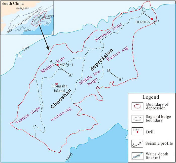
FIGURE 1. Survey line location and tectonic division map of the Dongsha Waters in the northern South China Sea.
In 2013, the Guangzhou Marine Geological Survey (GMGS) conducted the first hydrate drilling exploration in the northeastern Chaoshan depression and obtained evidence of hydrates at 8 sites of the 13 drilling sites. The hydrates occur in various forms such as massive, lamellar, veined, and nodular and scattered (Zhang et al., 2015). In 2019, another well, HD 2019-1 (Figure 1), was successful again in drilling gas hydrates from 60 m below the seabed in the same area. The new sampled hydrates comprise rich thermogenic gas (Zhong et al., 2020). However, the details of the hydrates and the geology have been less reported. Given the thin Cenozoic sediments, the underlying thick Mesozoic is inferred as the potential gas source for the hydrates (Zhong et al., 2020). More than 20 years of geophysical and geochemical surveys enable analysis of the source.
GMGS has conducted extensive 2D multi-channel seismic and seafloor site sampling surveys over the Dongsha Waters. Up to now, the seismic grid density of the central and western parts of the Chaoshan depression has reached 16 km × 32 km, locally 2 km × 4 km, being coarser in the northeast boundary. The most-used 2D seismic streamer has 480 channels in 12.5 m spacing. The shooting spacing is 37.5 m using a source capacity of 5080 cubic inches. The coverage is up to 80 fold. The seismic profiles displayed later have been processed with routine industry procedures and pre-stacked time migration.
The seismic data were interpreted with the GeoFrame 2012 software platform. The formation is interpreted primarily based on correlation with the geologic exploration of the MZ-1-1 well (Figure 2) and seismic stratigraphic analysis. On this basis, combined with the reflection characteristics of productive mudstone on the seismic profile, data were traced by section, and time-depth-thickness was converted and mapped.
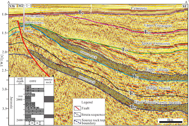
FIGURE 2. (A,A′) Seismic section typical of the mud hydrocarbon source layers developed in the Chaoshan depression (see line position in Figure 1).
With the drill-seismic correlation, a basin simulation was carried out using IES Petromod software, and the distribution plan of the source rock Ro was mapped.
Site geochemical samples were collected in the central and southwestern Chaoshan depression with a grid of 8 km × 16 km. About 200 samples were selected for testing with items ranging from top air, top air heavy hydrocarbons, acid hydrolyzed hydrocarbons, acid hydrolyzed hydrocarbons, heavy hydrocarbons, fluorescence spectrum, altered carbonates, methane oxidizing bacteria, and butane oxidizing bacteria. The tests were carried out in Hefei Training and Testing Center of Sinopec Asset Management Co., Ltd. The indicators of the top air, top air heavy hydrocarbons, acid hydrolyzed hydrocarbons, altered carbonates, and methane oxidizing bacteria were selected and comprehensively analyzed. After normalization of these indicators, the Kriging and moving average methods were respectively used to map the comprehensive anomaly distribution of geochemical exploration.
It was confirmed from the MZ-1-1 well that the Chaoshan depression had developed two sets of mainly hydrocarbon source rocks in the T3-J1 and bathyal—neritic and neritic facies in the J3. The organic carbon content of the 1800–2000 m section of late Jurassic was 0.18–1.15%, the average was 0.67%, belonging to poor hydrocarbon source rock. The thickness of hydrocarbon source rock in the 2100 m–2400 m section of in the T3-J1 was 46.16 m, and the organic carbon content was 1.00–1.48%, with an average of 1.32%, belonging to medium hydrocarbon source rock. These two sets of hydrocarbon source rocks were of organic matter type II2-III (Yang et al., 2008; Hao et al., 2009).
In the seismic section next to the MZ-1-1 well (Figure 2), the muddy rock layer featured medium-weak amplitude, weak continuous, and low—frequency or blank reflections. From interpretation of the seismic grid, both sets of source rocks thickened outward in various directions from the drilled high Mesozoic (Figure 3). The T3-J1 mudstone layer becomes much thick, larger than 1000 m to the northeast region of the eastern sag over where the HD2019-1 well was drilled. The J3 mudstone layer also thickens, to generally 400–800 m, toward the middle low bulge and the western sag, prevailing in the NE-SW direction.
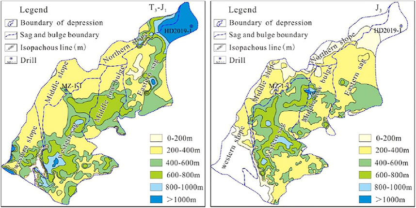
FIGURE 3. Map of mud rock thickness of the two main hydrocarbon source layers in the Chaoshan depression.
The mud hydrocarbon source rock of the J3 mainly develops in the lower layer, its seismic facies characteristics are weak amplitude, medium-high frequency, medium-weak continuous, locally blank reflection, or chaotic reflection configuration (Figure 2), belonging to the bathyal-neritic deposition. This set of mud rock is distributed in the western sag, the middle low bulge, and the southern part of eastern sag, elongating in the NE-SW direction with stable thickness at about 400–800 m (Figure 3).
Organic matter maturity is forwardly modeled based on seismic tying with the MZ-1-1 well where the hydrocarbon source rocks lie mostly below 1700 m. The maturity value, Ro, generally tends to increase sub-linearly with the formation depth from top to bottom (Figure 4), greater than 2.0% below 1700 m, and up to 3.0% at the bottom of the medium-upper Jurassic (about 2400 m). The hydrocarbon source rock has entered the late phase of over mature (Yang et al., 2008). The middle-upper Jurassic source rock reached low maturity to the end of the late Jurassic period. The lower cretaceous reached the late hydrocarbon-generating stage in the middle of the late Cretaceous period (Figure 4).
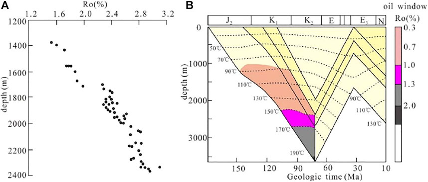
FIGURE 4. Profile of the vitrinite reflectance and hydrocarbon generation history of the MZ-1-1 well (Yang et al., 2008). (A) Ro profile; (B) hydrocarbon generation history profile).
On the plan view, the thickness of the T3-J1 hydrocarbon source rock increased with the formation deposition. Nowadays, except for the northern part of the northern slope and the eastern part of the eastern sag which are still in the immature-low mature stage (Ro<0.7%), the rest of the regions have entered the mature hydrocarbon-generating stage. Most of the western sag, the southern part of the western slope, the southern-central part of the eastern sag, and the middle low bulge central regions are all entering the over mature stage (Ro>2.0%) (Figure 5).
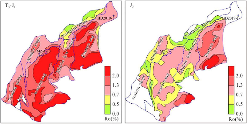
FIGURE 5. Current Ro value distribution of the main hydrocarbon source rock of the Chaoshan depression.
Except in the western slope, J3 hydrocarbon source rocks are in their immature stage in the middle slope, the northern slope, and the southern part of the middle low bulge; the low maturity-maturity stage is present in the other region. The central and southern part of the eastern sag and the southern part of the western sag enter into the gas generating stage (1.3% < Ro ≤ 2.0%), locally into the over mature stage (Figure 5). Therefore, the Chaoshan depression mainly developed two sets of hydrocarbon source rocks distributed in the NE-SW direction on the plane in T3-J1 and J3. Most of the hydrocarbon source rocks are in their mature to over-mature stage nowadays. The potential for Mesozoic thermogenic gas generation is great.
The Mesozoic in the Chaoshan depression faulted mainly in three strikes: NE, near SN, and near EW (Figure 6). The faults can be recognized as two generations, one during the Mesozoic and another during the Cenozoic Era (Figure 7). The earlier one has offset the Mesozoic sequences, generally with small throws, resulting in fragmented, weak, and chaotic reflections of the Mesozoic sequences. While the young one has more distributed fractures with lasting activity from the Pliocene to the Quaternary, which leads to instability and blank reflections of the young sediments.
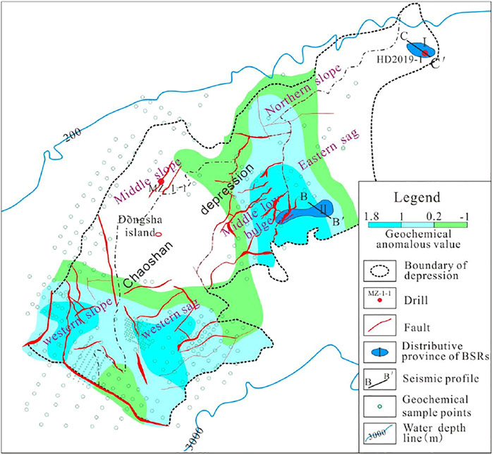
FIGURE 6. Map of sample site and oil and gas geochemical anomalies, and Mesozoic faults in Chaoshan depression.
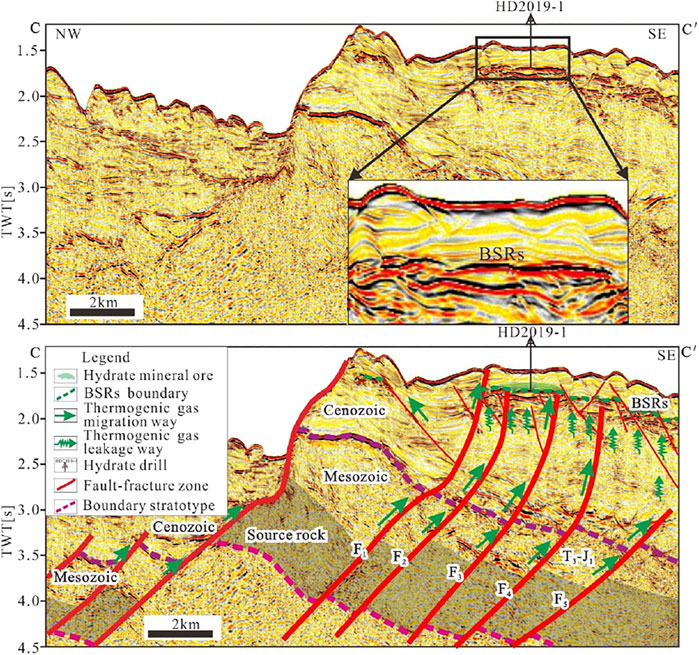
FIGURE 7. (C,C′) profile hydrate accumulation pattern analysis graph (see line position in Figure 1).
Widespread bottom simulating reflectors (BSRs) present the seismic profiles over the northeastern most corner of the Chaoshan depression, named as the NO. I BSR anomaly area, where the 2013 and 2019 drilling surveys were conducted with discoveries of hydrates. As an example, seismic profile C-C' (Figure 7) reveals that BSRs coincidently appeared above the fault-fracture zones, e.g., F1, F2, F3, F4, F5, and others. The association of the fault deep into the Mesozoic and fractures within the shallow covering sediments form good channels for the thermogenic gas to migrate vertically upward and diffuse as a hydrate ore body as an expression of the BSRs.
Submarine leakage of hydrocarbon leads to a geochemical anomaly on the seafloor. A quantified geochemical anomaly is calculated as described previously by normalization of five tested items over the sampled region. Its relative variation reflects the varying extent of hydrocarbon leakage.
Figure 6 shows that there are three obvious geochemical anomaly areas in the Chaoshan depression, i.e., in the western slope, the southern part of the western sag, and the junction area of the middle low bulge and the southern part of the eastern sag. They are potential areas of hydrocarbon leakage. Coincidently, these areas are distributed with numerous submarine mud volcanoes (Figure 8) which also usually indicates extensive leakage of oil and gas (Yan et al., 2017).
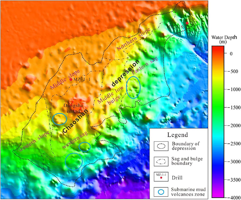
FIGURE 8. Distribution map of the submarine mud volcanoes in the Dongsha Waters (mud volcanoes according to Yan et al., 2017; Yan et al., 2022).
The overlap map of the geochemical anomalous area and the Mesozoic fault distribution shows a clear correlation between them (Figure 6). The geochemical anomaly is often high over the fault zones.
Most of the mapped faults cut through the two sets of source rocks in the Mesozoic, and break to the Cenozoic. The Cenozoic in this area is thin, generally, less than 1000 m, and does not have the gas source foundation for the formation of thermogenic gas. Therefore, it can be concluded that the hydrate thermogenic gas in this area mainly comes from the Mesozoic.
The thermogenic gas in the lower part of the Chaoshan depression hydrate ore body in Dongsha Waters comes from the Mesozoic (Figure 9). The deep region’s fault-fractures communicate the temperature and pressure stability region of the hydrate and the Mesozoic hydrocarbon source rock, and the deep thermogenic gas is migrated along the transport system to the overlying formation and mixed with the microbial gas, eventually forming hydrate. The fault plays a key role in the process of hydrate accumulation in the region. The Mesozoic fault development area is the main leakage area of thermogenic gas, and the gas source of thermogenic gas in this area is sufficient.
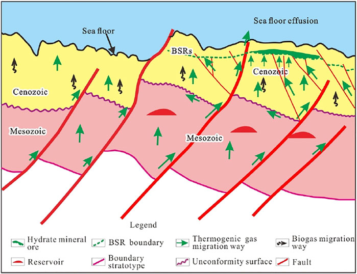
FIGURE 9. The schematic model for gas hydrate accumulation in the Chaoshan depression.
Apart from the northeastern most corner of the Chaoshan depression, the junction area of the middle low bulge and the southern most part of the eastern sag (Figure 6) is also found with a large span of clearly visible BSRs (Figure 10) over where high organic carbon is seen from results of the geochemical survey (Figure 6). Here the Mesozoic sequences develop more completely, with the T3- J1, J3 hydrocarbon source rock entering into a mature–over mature period. Similar fault-fractures, such as F6, F8, and F9, cut deep to Mesozoic, and branch upward as F7, F10, and more fractures (Figure 10) connecting with them, forming well passages for the thermogenic gas to migrate upward to the Cenozoic. Moreover, abundant authigenic carbonate nodules and deep-water fauna, e.g., shells, coral, and sponges, are found from dredged samples over some of the mud volcanoes by the area, which implies vigorous leakage of hydrocarbon (Zhong et al., 2020; Yan et al., 2021). Given the gas leakage condition and appearance of BSRs, the junction area of the middle low bulge and the southern most part of the eastern sag can be utilized as a future drilling target.
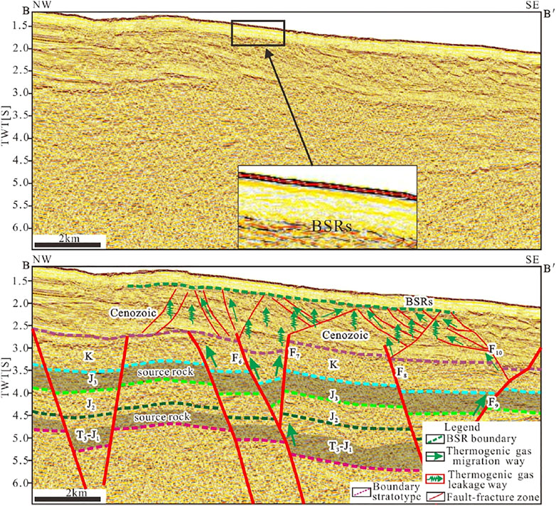
FIGURE 10. (B,B′) profile hydrate accumulation pattern analysis graph (see line position in Figure 1).
The oil and gas that leaked from the Mesozoic becomes the main source of thermogenic gas of the natural gas hydrate over the Dongsha Waters. The remaining hydrocarbon still can be traced through future exploration considering their wide distribution.
1) By regional correlation with previous drilling results of MZ-1-1, the Mesozoic source rocks are widely distributed over the Dongsha Waters, including the northeastern corner of the Chaoshan depression where hydrates were drilled. They source rocks are well matured to produce sufficient thermogenic gas contributing to hydrates.
2) Geochemical anomalies hinting at the micro-leakage of oil and gas from the deep are well correlated with zones of the Mesozoic fault-fractures which act as good transport channels for the thermogenic gas to leak and diffuse.
3) Enrichment of the Mesozoic thermogenic gas source in the gas hydrate is of great significance for hydrate and Mesozoic petroleum exploration.
The original contributions presented in the study are included in the article/Supplementary Material, further inquiries can be directed to the corresponding authors.
The author CF and GZ completed the main body of the paper. MS calculated the thickness map. Others participated in the preparation of the map.
The authors declare that the research was conducted in the absence of any commercial or financial relationships that could be construed as a potential conflict of interest.
All claims expressed in this article are solely those of the authors and do not necessarily represent those of their affiliated organizations, or those of the publisher, the editors and the reviewers. Any product that may be evaluated in this article, or claim that may be made by its manufacturer, is not guaranteed or endorsed by the publisher.
Three reviewers are thanked for their constructive comments and suggestions. This research was funded by the secondary project of China Geological Survey(DD20221860, DD20190212).
Chen, B., Wang, J. L., Zhong, H. Z., and Hao, H. J. (2005). Geophysical Study of Pre-tertiary Basin Style of Chaoshan Sag in South China Sea. J. Tongji Univ. (Natural Science) 33, 1274–1280. Available at: https://kns.cnki.net/kcms/detail/detail.aspx?dbcode=CJFDanddbname=CJFD2005andfilename=TJDZ200509027andv=MTEyNDZZUzdEaDFUM3FUcldNMUZyQ1VSN2lmWStadUZ5bmhVcnJOTVNmUGRMRzRIdFRNcG85SFk0UjhlWDFMdXg=
Han, X. Q., Yang, K. H., and Huang, Y. Y. (2013). Origin and Nature of Cold Seep in Northeastern Dongsha Area, the South China Sea: Evidence from Chimney-like Seep Carbonates. Chin. Sci. Bull. 58, 1865–1873. doi:10.1007/s11434-013-5819-x
Hao, H. J., Lin, H. M., Yang, M. X., Xue, H. Y., and Chen, J. (2001). The Mesozoic in Chaoshan Depression: a New Domain of Petroleum Exploration. China Offshore Oil and Gas 15, 157–163. Available at: https://kns.cnki.net/kcms/detail/detail.aspx?dbcode=CJFDanddbname=CJFD2001andfilename=ZHSD200103000anduniplatform=NZKPTandv=zLQGLhpKClZwe3o6p34gwP_7lpX_oKnS1CUEXPkK4DgZnGtFENF231n3XTySl8PE
Hao, H. J., Shi, H. S., Zhang, X. T., Jiang, T. C., and Tang, S. L. (2009). Mesozoic Sediments and Their Petroleum Geology Conditions in Chaoshan Sag: a Discussion Based on Drilling Results from the Exploratory Well LF35-1-1. China Offshore Oil and Gas 21, 151–156. Available at: https://kns.cnki.net/kcms/detail/detail.aspx?dbcode=CJFDanddbname=CJFD2009andfilename=ZHSD200903001anduniplatform=NZKPTandv=9wmqc4yDGf7coDxOI3W_QlTzYls3Df4rmRD3rcgSXJ6mVS0tpm1c9YcwubOW7tUE
He, J. X., Yan, W., Zhu, Y. H., Zhang, W., Gong, F. X., Liu, S. L., et al. (2013). Bio-genetic and Sub-biogenetic Gas Resource Potential and Genetic Types of Natural Gas Hydrates in the Northern Marginal Basins of South China Sea. Nat. Gas Industry 33, 121–134. doi:10.3787/j.issn.1000-0976.2013.06.023
He, J. X., Zhong, C. M., Yao, Y. J., Yan, P., Wang, Y. L., Wan, Z. F., et al. (2020). The Exploration and Production Test of Gas Hydrate and its Research Progress and Exploration prospect in the Northern South China Sea. Mar. Geology. Front. 36, 1–14. doi:10.16028/j.1009-2722.2020.127
Liang, J. Q., Zhang, G. X., Lu, J. A., Su, P. B., Sha, Z. B., Gong, Y. H., et al. (2016). Accumulation Characteristics and Genetic Models of Natural Gas Hydrate Reservoirs in the NE Slope of the South China Sea. Nat. Gas Industry 36, 157–162. doi:10.3787/j.issn.1000-0976.2016.10.020
Qiang, K. S., Zhang, G. X., Zhang, L., Lv, B. F., Zhong, G. J., Feng, C. M., et al. (2018). A Study of Depositional Characteristics of the Jurassic Strata in Chaoshan Sub-basin, Northern South China Sea, and its Control on Reservoir Beds. Geology. China 45, 48–58. doi:10.12029/gc20180105
Sha, Z. B., Xu, Z. Q., Fu, S. Y., Liang, J. Q., Zhang, W., Su, P. B., et al. (2019). Gas Sources and its Implications for Hydrate Accumulation in the Eastern Pearl River Mouth Basin. Mar. Geology. Quat. Geology. 39, 116–125. doi:10.16562/j.cnki.0256-1492.2019010902
Shao, L., You, H. Q., Hao, H. J., Wu, G. X., Qiao, P. J., and Lei, Y. C. (2007). Petrology and Depositional Environments of Mesozoic Strata in the Northeastern South China Sea. Geol. Rev. 53, 164–169. Available at: https://kns.cnki.net/kcms/detail/detail.aspx?dbcode=CJFDanddbname=CJFD2007andfilename=DZLP200702004anduniplatform=NZKPTandv=KltIONSOe0fHeETIqY1QtFzN1TPRFED6SFMbehBWY0zPARPbOucyyzYL0_ybZV6c
Su, P. B., Liang, J. Q., Fu, S. Y., Lv, W. J., and Gong, Y. H. (2017). Geological Background and Accumulation Models of Gas Hydrate Reservoir in Northern South China Sea. Geology. China 44, 415–427. doi:10.12029/gc20170301
Su, P. B., Sha, Z. B., Chang, S. Y., Liang, J. Q., and Fu, S. Y. (2014). Geological Models of Gas Hydrate Formation in the Eastern Sea Area of the Pearl River Mouth Basin. Nat. Gas Industry 34, 162–168. doi:10.3787/j.issn.1000-0976.2014.06.26
Sun, M., Ren, J. F., Zhong, G. J., and Yi, H. (2018). Fold Deformations of Mesozoic Strata and Their Genetic Mechanism in Southwestern Dongsha Waters of Northern South China Sea. Geol. Rev. 64, 828–842. doi:10.16509/j.georeview.2018.04.003
Teng, T. T., Su, X., Liu, H. D., Cui, H. P., Chen, F., Cheng, S. H., et al. (2020). Archaeal Diversity in Sediments of Core 973-5 from Deep-Sea Cold Seep, Dongsha Area in South China Sea. Geoscience 34, 104–116. doi:10.19657/j.geoscience.1000-8527.2019.009
Wu, G. X., Wang, R. J., Hao, H. J., and Shao, L. (2007). Microfossil Evidence for Development of Marine Mesozoic in the North of South China Sea. Mar. Geology. Quat. Geology. 27, 79–85. Available at: https://kns.cnki.net/kcms/detail/detail.aspx?dbcode=CJFDanddbname=CJFD2007andfilename=HYDZ200701014anduniplatform=NZKPTandv=scsCLrFrBHbYPzGMgb8QCrH1YG-7mzkQWmv96Wi81yBiPRhKLkUg3TlVwMTPPxI7
Yan, P., Wang, Y., Liu, J., Zhong, G., and Liu, X. (2017). Discovery of the Southwest Dongsha Island Mud Volcanoes amid the Northern Margin of the South China Sea. Mar. Pet. Geology. 88, 858–870. doi:10.1016/j.marpetgeo.2017.09.021
Yan, P., Wang, Y. L., Jin, Y. B., Zhao, M. X., and Zhong, G. J. (2021). Deep-water Coral of Multiple Benthal Strategies Discovered from mounds in the Dongsha Waters in the South China Sea. Earth Sci. Front. doi:10.13745/j.esf.sf.2022.1.13
Yan, Y., Liao, J., Yu, J., Chen, C., Zhong, G., and Wang, Y. (2022). Velocity Structure Revealing a Likely Mud Volcano off the Dongsha Island, the Northern South China Sea. Energies 15, 195, 1–18 doi:10.3390/en15010195
Yang, S. C., Tong, Z. G., He, Q., and Hao, J. R. (2008). Mesozoic Hydrocarbon Generation History and Igneous Intrusion Impacts in Chaoshan Depression, South China Sea: a Case of LF35-1-1 Well. China Offshore Oil and Gas 20, 152–156. Available at: https://kns.cnki.net/kcms/detail/detail.aspx?dbcode=CJFDanddbname=CJFD2008andfilename=ZHSD200803002anduniplatform=NZKPTandv=PQDF9xpW_G1zCXbFA5lqpfH6NiGiKTabS1erksKv_rAVoUWu-zKPpXSC2LrtRUO3
Zhang, G., Liang, J., Lu, J. a., Yang, S., Zhang, M., Holland, M., et al. (2015). Geological Features, Controlling Factors and Potential Prospects of the Gas Hydrate Occurrence in the East Part of the Pearl River Mouth Basin, South China Sea. Mar. Pet. Geology. 67, 356–367. doi:10.1016/j.marpetgeo.2015.05.021
Zhang, W., Liang, J. Q., Lu, J. A., Wei, J. G., Su, P. B., Fang Y, X., et al. (2017). Accumulation Features and Mechanisms of High Saturation Natural Gas Hydrate in Shenhu Area, Northern South China Sea. Pet. Exploration Develop. 44, 670–680. doi:10.1016/s1876-3804(17)30082-4
Zhao, Z. Q., Sun, M., Wan, X. M., Chen, S. H., Zhao, J., Song, L. J., et al. (2020). The Application of Microbial Exploration Technology to the Oil and Gas Survey of Chaoshan Depression. Geology. China 47, 645–654. doi:10.12029/gc20200306
Keywords: chaoshan depression, the dongsha waters in the northern south china sea, mesozoic erathem, source of gas hydrate, gas channel by fault-fracture association
Citation: Feng C, Zhong G, Sun M, Lei Z, Yi H and Zhao Z (2022) Analysis of the Thermogenic Gas Source of Natural Gas Hydrates Over the Dongsha Waters in the Northern South China Sea. Front. Earth Sci. 10:873615. doi: 10.3389/feart.2022.873615
Received: 11 February 2022; Accepted: 18 March 2022;
Published: 09 May 2022.
Edited by:
Zhifeng Wan, Sun Yat-sen University, ChinaReviewed by:
Yan Pin, South China Sea Institute of Oceanology (CAS), ChinaCopyright © 2022 Feng, Zhong, Sun, Lei, Yi and Zhao. This is an open-access article distributed under the terms of the Creative Commons Attribution License (CC BY). The use, distribution or reproduction in other forums is permitted, provided the original author(s) and the copyright owner(s) are credited and that the original publication in this journal is cited, in accordance with accepted academic practice. No use, distribution or reproduction is permitted which does not comply with these terms.
*Correspondence: Changmao Feng, ZmVuZ2NoYW5nbUAxNjMuY29t; Guangjian Zhong, MjY0NTA3ODkwNkBxcS5jb20=
Disclaimer: All claims expressed in this article are solely those of the authors and do not necessarily represent those of their affiliated organizations, or those of the publisher, the editors and the reviewers. Any product that may be evaluated in this article or claim that may be made by its manufacturer is not guaranteed or endorsed by the publisher.
Research integrity at Frontiers
Learn more about the work of our research integrity team to safeguard the quality of each article we publish.