 Yunping Yang
 Wanli Liu1
- 1Tianjin Research Institute for Water Transport Engineering, Ministry of Transport, Tianjin, China
- 2State Key Laboratory of Hydrology-Water Resources and Hydraulic Engineering, Hohai University, Nanjing, China
- 3State Key Laboratory of Hydraulic Engineering Simulation and Safety, Tianjin University, Tianjin, China
- 4Changjiang Hydrology Bureau, Changjiang Water Resources Commission, Wuhan, China
Human activities and climate change have profoundly changed the hydrological and geomorphological evolutionary processes and trends of rivers and lakes, which, in turn, has affected the utilization of their waterway depth. This study chose the Dongting Lake–Jingjiang confluence of the Changjiang River (Yangtze Rvier), since the operation of the Three Gorges Project, the split ratio of water and the sediment distribution of the three outlets of Dongting Lake—that is, Songzikou, Taipigkou, and Ouchikou—have continued to decrease. Along with the decreasing flow of Dongting Lake, the relative increase in the runoff of the Jingjiang reach and the increase in riverbed erosion intensity have increased the relative height difference between Jingjiang and Dongting Lake, intensifying the reduction of the split ratio of water and the sediment distribution of the three outlets. The riverbed erosion of the Jingjiang reach has created a promising foundation for an increase in the waterway dimensions. However, the length of the reach not meeting the requirements of 4.5× 200 m (water depth × width) is 18.4 km, of which the length in the river-lake confluence is 12.6 km, accounting for 68.35% of the total length of obstructed navigation. Furthermore, at the reach (Zhicheng–Dabujie reach) affected by the first outlet (Songzikou), a 4.5-m flume has been formed, but its width is less than 200 m. Moreover, the “steep slope and rapid current” phenomenon is clear, and it affects the safety of ships. At the reach (Taipingkou reach) affected by the second outlet, the shrinkage of the bottomland, and the intersecting braided river channels make the low-flow routes unstable, the water depth being less than 4.5 m. At the reach (Tianxingzhou–Ouchikou reach) affected by the third outlet, the shoreline of the reach has collapsed and retreated significantly. Additionally, beach erosion and the downstream movement of cut banks have caused the downstream waterway width at the reach to be reduced to less than 200 m or formed shoals with a water depth of less than 4.5 m. Owing to the jacking effect of the lake’s outflow backwater, the flow rate of the reach (Xiongjiazhou–Chenglingji reach) affected by the confluence of Dongting Lake decreased, creating a shoal with a water depth of less than 4.5 m in the navigation waterway. The results of this study have guiding significance for understanding the changes of channel conditions and the improvement of channel scale in the intersection area of rivers and lakes.
Introduction
Against the background of intense human activities and global climate change, the hydrology, sedimentation, and landform processes of most lakes globally have changed tremendously (Yu et al., 2018; Mammides, 2020; Grant et al., 2021). Dongting Lake is the second-largest freshwater lake in China and an important lake in the middle reaches of the Changjiang River. Incoming water from the upper reaches of the Changjiang River enters Dongting Lake through Songzikou, Taipingkou, and Ouchikou. Meanwhile, Dongting Lake also receives the “four rivers”—that is, the Xiangjiang River, Zishui River, Yuanjiang River, and Lishui River—which flow from Chenglingji to the Changjiang River, forming a complex river-lake relationship with the Changjiang River (Huang et al., 2012), It affects the disaster prevention and mitigation of river basin flood (Duan et al., 2016), water quality safety (Duan et al., 2018) and economic and social development (Duan et al., 2016). Owing to the impact of climate and human activities, the relationship between Dongting Lake and the Changjiang River has undergone many changes since the beginning of the 20th century (Han et al., 2016; Zheng, 2016; Dai et al., 2017). The opening and operation of the Three Gorges Project in June 2003 meant that the river-lake relationship had entered a new period of change (Hu et al., 2013; Lai et al., 2014; Fang et al., 2014; Zhan et al., 2015; Li et al., 2021a).
Over the past 20 years, researchers have been studying the impact of the Three Gorges Reservoir operation on the river-lake relationship in terms of the spatial and temporal evolution of water and sediment in the Dongting Lake (Nakayama and Watanabe, 2008; Zhang et al., 2016), the water exchange capacity of the Changjiang River and Dongting Lake (Li et al., 2013; Ou et al., 2014; Zhu et al., 2016; Lai and Wang, 2017; Mao et al., 2017), floods (Jiang et al., 2007; Huang et al., 2014; Lai and Wang, 2017; Wu et al., 2019; Geng et al., 2021), the volumes of the river and lake (Liao et al., 2018; Lu et al., 2018), and ecological and environmental factors (Zhang et al., 2016; Lu et al., 2018; Zhang et al., 2020). The Three Gorges Reservoir operation has affected the flow of the Changjiang River (Wang et al., 2016), causing the early dry out of Dongting Lake and the volume of water entering the lake through the three outlets to decline (Zhou and Zhang, 2018). From 2003 to 2008, natural inflow, reservoir regulation, and riverbed erosion contributed 76.19%, 10.32%, and 13.49% to the process of reducing the flow through the three outlets of Dongting Lake. Moreover, from 2009 to 2015, the respective figures were 66.05%, 19.75%, and 14.20% (Chen et al., 2018). The Three Gorges Reservoir’s impoundment during the flood recession period further reduced the water level of Dongting Lake. Combined with the upstream cascade reservoirs, the impact on Dongting Lake increased (Fang et al., 2014).
The Jingjiang Cut-off Project was the main reason for the decrease in the volume of sediment coming out of Dongting Lake from 1971 to 2002. With the operation of the Three Gorges Reservoir, siltation in the lake area changed to erosion (Zhou et al., 2016; Zhu et al., 2016; Lu et al., 2018) and bottomland shrinkage (Yu et al., 2019). For example, a mathematical model predicts that after the Three Gorges Project has been in operation for 20 years, the decrease in the middle and high-water levels of the Jingjiang reach will be limited, but the riverbed elevation of the flood channels at the three outlets will decrease significantly, although the diversion ratio of the three outlets will not decrease (Li et al., 2009). Under a scenario in which the lake volume remains constant, the reduction in the volume of water outflow from Dongting Lake is approximately 23% of the water storage capacity of the Three Gorges Reservoir (Zhang et al., 2019); under a scenario with different flow-water levels, the jacking strength between floods of the river and lake are both weakened (Duan et al., 2019; Liu et al., 2019); under a scenario with the same flow from the Zhicheng Hydrological Station of the Changjiang River, the flow of the Jianli Hydrological Station is weakened by the jacking of the Dongting Lake outflow, which is also weakened by the jacking of the discharge water of Jingjiang reach (Yu et al., 2017).
Since the operation of the Three Gorges Reservoir, the erosion of the Dongting Lake area has caused the low water level to increase and the depth of the waterway to increase (Zhang et al., 2015). The phase 1 waterway regulation project has been implemented in the Jingjiang reach, and the waterway depth has been increased from 2.9 m in 2002 to 3.5–3.8 m in 2020 (Yan et al., 2019; Yang et al., 2019). An inspection of waterway conditions found that the depth of the waterways from Yichang to Wuhan and Wuhan to Anqing had favorable conditions, increasing from 3.5 m and 4.5 m to 4.5 m and 6.0 m, respectively (Yang et al., 2019). Meanwhile, the complex relationship between the hydrodynamic, sediment discharge, and bottomland evolution in the confluence area of Dongting Lake and the Changjiang River has been noted, a key reach for waterway management and dredging maintenance (Dong et al., 2020). Existing studies have also focused on changes in riverbed erosion and silting (Xia et al., 2016; Xia et al., 2017; Yang et al., 2017; Yang Y. et al., 2018; Yang et al., 2018b; Yang et al., 2018c), bottomland changes (Zhao et al., 2020; Yang et al., 2021), diversion relationships (Liu et al., 2017; Hu et al., 2020; Yang et al., 2021), and navigation obstruction characteristics (Yan et al., 2012; Yang et al., 2019; Li et al., 2021b) in the confluence area of Dongting Lake and Changjiang River since the operation of the Three Gorges Reservoir. The existing studies have paid little attention to the influence of the adjustment of diversion relationship of Dongting Lake on channel conditions in the intersection area of river and lake, especially the influence on the development and utilization of water depth resources in the main channel of the Changjiang River.
The shipping function of the river supports economic and social development along the river. Until 2020, the water discharge volume of the Changjiang River has been 30.6 × 10⁸ t, accounting for 78.6% of that of China’s inland rivers. However, previous studies have rarely examined changes in waterway depth in the confluence areas of rivers and lakes. Consequently, using the Jingjiang reach, which is affected by the confluence of the Changjiang River and Dongting Lake, as the research object, the water, sediment, and contour data of the Changjiang River–Dongting Lake region from 1955 to 2020 were used to study the hydrological effects of Dongting Lake and the impact of the overbank evolution of the Jingjiang reach on the waterway conditions at the river-lake confluence area, as well as to analyze the influence of the changing river-lake relationship on the waterway conditions of the Jingjiang reach of the Changjiang River.
Research Area
Overview of Dongting Lake and Changjiang River
The Jingjiang reach (Zhicheng–Chenglingji reach) is located in the middle reaches of the Changjiang River (Figure 1A), with a total length of 375 km. Dongting Lake is located on the south bank of the Changjiang River. Water diverges and enters Dongting Lake from Songzikou, Taipingkou, and Ouchikou, merging into the Changjiang River at Chenglingji (Figure 1B). The hydrological stations along the Jingjiang reach are Zhicheng, Shashi, Jianli, and Luoshan Hydrological Stations. The hydrological Stations at Songzikou of Dongting Lake are Xinjiangkou Station and Shadaoguan Station, at Taipingkou the Hydrological Station is Mituosi Station, at Ouchikou the hydrological stations are Tangjiagang Station and Guanjiapu Station, and at the confluence into the Changjiang River, the hydrological station is Chenglingji Station (Figure 1C).
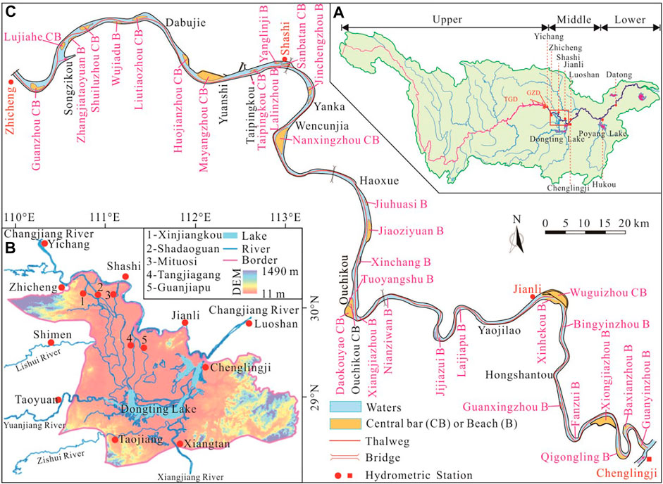
FIGURE 1. Overview of the middle reaches of the Changjiang River and Dongting Lake; (A) Changjiang River Basin; (B) Relationship between Dongting Lake and Jingjiang reach; (C) Jingjiang reach.
Waterway Regulation Project
Songzikou is the first diversion area from the Changjiang River to Dongting Lake, covering the reach from Zhicheng to Changmenxi, the distributed central bars being Guanzhou and Lujiahe, the waterway regulation project (Figure 2A) being implemented in the Zhicheng–Changmenxi reach from 2013 to 2017. The purpose was to stabilize the diversion relationship and have a good overbank shape. The control target was 3.5 × 150 × 1,050 m (water depth × width × bending radius).
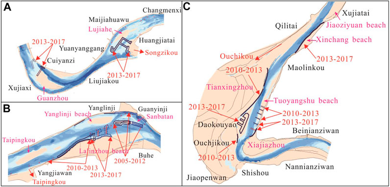
FIGURE 2. Waterway regulation project; (A) Zhicheng–Changmenxi reach; (B) Taipingkou reach; (C) Tianxingzhou–Ouchikou reach.
Taipingkou is the second diversion area from the Changjiang River to Dongting Lake, covering the Taipingkou reach, the distributed central bars being Taipingkou and Sanbatan, and the beaches being Lalinzhou and Yanglinji. From 2005 to 2012, two phases of waterway regulation projects were implemented at Sanbatan, mainly to stabilize it, and from 2010 to 2017, two phases of Lalinzhou protection projects were implemented to stabilize the waterway boundaries (Figure 2B).
Ouchikou is the third diversion area from the Changjiang River to Dongting Lake, covering the Tianxingzhou–Ouchikou reach, with the Xinchang Beach, Tianxingzhou, Tuoyangshu Beach, Ouchikou central bars, Doukouyao central bars, and Xiangjiazhou Beach. The bars most directly affected by the diversion of Ouchikou are the Tianxingzhou and Tuoyangshu Beaches. From 2010 to 2013, the protection of the high bar on the left of Tianxingzhou, the lower section of the Tuoyangshu Beach, and the bank protection project was implemented, and from 2013 to 2017, the Dakouyao central bars, Tuoyangshu Beach, and Xinchang Beach protection projects were implemented to stabilize the waterway boundary and increase the waterway water depth to 3.5 m and above (Figure 2C).
Research Data, Methods, and Models
Data
The water level, water, and sediment data of Zhicheng, Shashi, Jianli, and Luoshan Hydrological Stations from 1955 to 2020 were collected to analyze changes in the water and sediment conditions in the Jingjiang reach. Data on the water and sediment volume of Songzikou (Xinjiangkou, Shadaoguan Hydrological Station), Taipingkou (Mituosi Hydrological Station), Ouchikou (Guanjiapu, Tangjiagang Hydrological Stations), and Chenglingji Hydrological Station of Dongting Lake from 1955 to 2020 were collected to analyze the water and sediment conditions of the Dongting Lake area, the contour data of the riverbed of the Jingjiang reach (Zhicheng–Chenglingji reach) being collected to analyze the waterway conditions, bottomland deformation, and cross-section changes in the Dongting Lake–Jingjiang confluence area (Table 1).
TABLE 1. Data characteristics and sources.
Calculation Method of Branch Diversion Ratio and Waterway Dimension
The navigational datum is the water level H0 corresponding to the position of a section, usually the water surface line along the river course with a 98% guarantee calculated using the synthetic duration curve method (Figure 3A) (Changjiang Waterway Bureau, 2014). In addition, the difference between the water level of the navigational datum and the elevation of the waterway bottom is the water depth (h). The dimensions of a waterway include its water depth (H), width (B), bend radius (R), and navigation clearance height (Hmax). If the water depth corresponding to the actual lowest navigable water level (h) is less than the target navigation depth (H), a break will appear in the depth contour corresponding to H—a navigation obstacle due to insufficient water depth (Figure 3B). If a location on the waterway has h greater than H—the depth contour at H is not broken—but a width less than B, the location is a navigation obstacle caused by insufficient navigable width. Similarly, if R is too small for safe passage, route adjustments may lead to insufficient waterway width and/or depth.
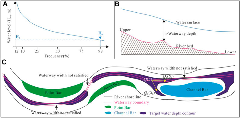
FIGURE 3. Calculation process of waterway depth, ratios of water and sediment. (A) Determination of lowest navigable water level; (B) Waterway water depth calculation process; (C) Calculation of navigation obstruction ratios of water and sediment.
The calculation of the split ratios of water and sediment ratios (Figure 3C) is as follows: firstly, the total inflow of the braided reach Q and S is obtained by measuring the runoff at the cross-section of its inlet. If the runoff flowing into each branch is Qi and Si (i = 1, 2, … , n where n is the number of branches), the split ratios of water and sediment distribution ratios ηi and ξi of each branch is given by:
Calculation Method of Riverbed Erosion and Deposition
The amount of sediment erosion and silting in the Jingjiang reach can be calculated using the sediment discharge method. The upstream control station is the Zhicheng Station (SZhicheng, 108 t/y), and the downstream control station is the Luoshan Station (SLuoshan, 108 t/y). Sediment diverges from Songzikou, Taipingkou, and Ouchikou into Dongting Lake—that is, (Sthree outlets = SSongzikou+STaipingkou + SOuchikou, 108 t/y). The difference in sediment discharge volume between the upstream and downstream, plus Dongting Lake, is the amount of sediment erosion and silting in the Jingjiang reach (VJingjiang reach, 108 t/y), which can be calculated as follows:
The hydrological control stations at Songzikou are Xinjiangkou (SXinjiangkou, 108 t/y) and Shadaoguan (SShadaoguan, 108 t/y); the hydrological control station at Taipingkou is Mituosi (SMituosi, 108 t/y); the hydrological control stations at Ouchikou are Guanjiapu (SGuanjiapu, 108 t/y) and Tangjiagang (STangjiagang, 108 t/y). Consequently, the formula for sediment erosion and deposition can be expressed as follows:
Research Results
Runoff and Sediment Variation of Changjiang River
From 1955 to 2002 and 2003 to 2020, the runoffs of Zhicheng, Shashi, Jianli, and Luoshan Hydrological Stations were 4,450 × 108 m3/y, 3,933 × 108 m3/y, 3,567 × 108 m3/y, and 6,408 × 108 m3/y and 4,282 × 108 m3/y, 3,907 × 108 m3/y, 3,780 × 108 m3/y, and 6,222 × 108 m3/y, respectively, the variations being −3.76%, −0.65%, +5.95%, and −2.90% (Figure 4A). From 1955 to 2020, the sediment at the Zhicheng, Shashi, Jianli, and Luoshan Hydrological Stations exhibited a decreasing trend. From 1955 to 2002 and 2003 to 2020, the sediment at the Zhicheng, Shashi, Jianli, and Luoshan Hydrological Stations were 5.00 × 10⁸, 4.33 × 10⁸, 3.70 × 10⁸, and 4.11 × 10⁸, and 0.42 × 10⁸ t/y, 0.52 × 10⁸, 0.68 × 10⁸, and 0.84 × 10⁸ t/y, respectively, the variations being −91.58%, −87.95%, −81.53%, and −79.45% (Figure 4B).
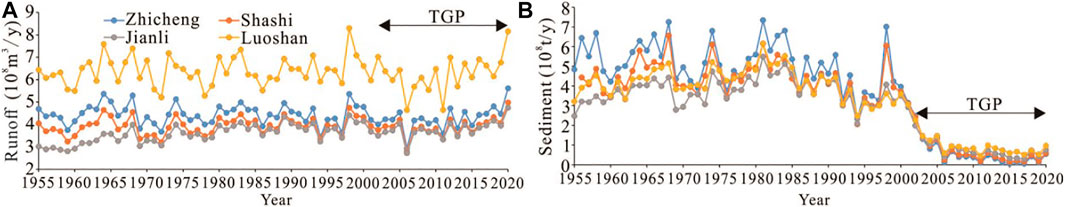
FIGURE 4. Runoff and sediment in the mainstream of Changjiang River; (A) Runoff; (B) Sediment.
Variation of Runoff and Sediment in Dongting Lake
From 1955 to 2002 and 2003 to 2020, the runoffs of Songzikou, Taipingkou, and Ouchikou of Dongting Lake were 419 × 108, 163 × 108, and 336 × 108 m3/y, and 306 × 108 m3/y, 81 × 108 m3/y, and 111 × 108 m3/y respectively, the extent of the decrease being 26.97%, 50.31%, and 66.96% (Figure 5A). The extent of the decrease between all three outlets was 48.00% (Figure 5C). From 1955 to 2002 and 2003 to 2020, the sediment of Songzikou, Taipingkou, and Ouchikou of Dongting Lake were 4,652 × 104, 1887 × 104, and 5,842 × 104, and 474 × 104, 116 × 104, and 282 × 104 t/y, respectively, the extent of the decrease being 89.81%, 93.85%, and 95.17% (Figure 5B). The extent of the decrease in sediment between all three outlets was 92.94% (Figure 5C). Comparing the data from 2003 to 2020 with that from 1955 to 2002, the runoff of Chenglingji Hydrological Station decreased by 13.84% (Figure 6). From 1955 to 2007, the amount of sediment at Chenglingji Station showed a decreasing trend, whereas from 2007 to 2012 it increased slightly, before showing a decreasing trend from 2013 to 2020 (Figure 5D). Comparing the data from 2003 to 2020 with that from 1955 to 2002, the amount of sediment at Chenglingji Station decreased by 55.8%.
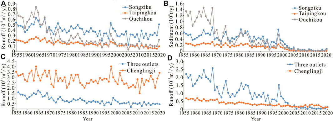
FIGURE 5. Three outlets diversion relationship of Dongting Lake; (A) Runoff of Songzikou, Taipinghkou, and Ouchikou; (B) Sediment of Songzikou, Taipinghkou, and Ouchikou; (C) Runoff of three outlets and Chenglngji of Dongting Lake; (D) Sediment of three outlets and Chenglngji of Dongting Lake.
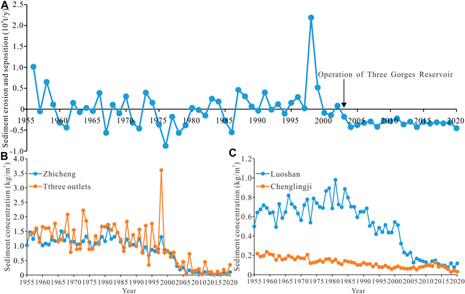
FIGURE 6. Sediment scouring, sediment concentration, deposition in Jingjiang reach and Dongting Lake; (A) Sediment erosion and deposition; (B) Comparison of sediment content in three outlets of Dongting Lake and mainstream of Changjiang River; (C) Sediment content of Chenglingji Hydrological Station and Luoshan Hydrological Station.
Since 1955, affected by the cut-off of the Lower Jingjiang reach, the construction of the Gezhouba Dam, and the Tree Gorges Dam, the river regime change at the gate section of the three outlets, and other factors, the riverbed of the Jingjiang reach has been eroded. Furthermore, at the same flow rate, the water level has dropped and the riverbeds of the splitting channels of the three outlets have been silted up-that is, the split ratio of water and the sediment distribution capacities of the three outlets have been in a state of attenuation (Table 2). From 1955 to 1966, the split ratios of water and sediment of the three outlets of Dongting Lake were 29.8% and 35.4%, respectively; during the systematic cut-off period of the Lower Jingjiang reach from 1967 to 1972, the split ratio water and the sediment distribution ratio of the three outlets were 23.7% and 28.3%, respectively, 6.1% and 7.1% less than before the cutting off. From 1973 to 1980, the decay rate of the split ratio of water and the sediment distribution capacity of the three outlets increased, with the average distribution ratios being 18.8% and 21.6%, respectively. After the Gezhouba Dam was built in 1981, the decay rate of the diversion ratios of the three outlets slowed down from 1981 to 1998. The split ratio of water and the sediment distribution ratio of the three outlets were 14.0% and 16.4% from 1999 to 2002 and 11.6% and 20.7% from 2003 to 2020, respectively. In other words, with the operation of the Three Gorges Project, the split ratio of water of the three outlets decreased by 2.4%, and the sediment distribution ratio increased by 4.3%. From 1955 to 2002, the sediment distribution ratio of the three outlets of Dongting Lake was higher than the split ratio—the split effect of the three outlets caused the sediment content of the Jingjiang reach to trend downwards. From 2003 to 2020, the sediment distribution ratio was higher than the split ratio of water by approximately 9.1%, which was higher than the 2.4%–5.6% difference in the period 1955–2002, before the impoundment of the Three Gorges Project, further increasing the erosion intensity of the Jingjiang reach.
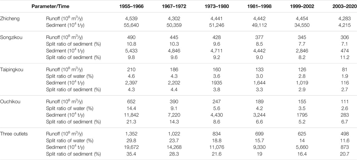
TABLE 2. Runoff and sediment quantity, split ratio of water and the sedimentof the three outlets of Dongting Lake.
Sediment Deposition in Jingjiang Reach
From 1955 to 2002, the riverbed of the Jingjiang reach was alternately eroded and silted. From 2003 to 2020, it was in a state of continuous scouring, the cumulative erosion total being 5.98 × 10⁸ t, and the annual erosion total being 0.33 × 10⁸ t/y (Figure 6A). From 2003 to 2020, 39.4% of the sediment volume at Luoshan Hydrological Station was from the erosion of the Jingjiang reach, 10.7% was due to the exchange interaction with Dongting Lake, and 49.9% was from the river basin upstream of Zhicheng Station. Before the operation of the Three Gorges Project, the sediment content of the three outlets was higher than that of the Jingjiang reach during the medium flood years. After the operation of the Three Gorges Project, the sand content of the three outlets was higher than that of the Jingjiang reach. In other words, the changes in Dongting Lake’s sediment distribution from 2003 to 2020 have caused the Jingjiang reach to erode (Figure 6B); the sediment content of Chenglingji Station, where Dongting Lake convergences into the Changjiang River, is lower than that of Luoshan Hydrological Station on the Changjiang River, its confluence effect aggravating the sediment erosion in the Jingjiang reach (Figure 6C).
Verification of Waterway Conditions
The water depths of the Jingjiang reach waterway were tallied based on the river contour that was surveyed in October 2020 (Figure 7). Given a waterway width of 200 m, it was found that there were 14 waterwar with water depths less than 4.5 m in the Jingjiang reach, including the Guanzhou, Lujiahe, Zhijiang, Jiangkou, Dabujie, Yuanshi, Taipingkou, Wakouzi, Zhougongdi, Jianli, Damazhou, Tiepu, Chibakou, and Guanyinzhou waterways. The minimum water depths of the 19 remaining waterways were all greater than 4.5 m.
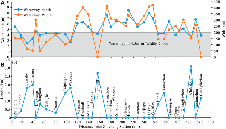
FIGURE 7. Verification of waterway conditions; (A) Minimum water depth and width; (B) Length not meeting 4.5 × 200 m.
After drawing a 4.5 m depth contour through the Jingjiang reach, it was found that there were 13 waterways with widths less than 200 m, that is, the Zhicheng, Guanzhou, Lujiahe, Zhijiang, Jiangkou, Dabujie, Yuanshi, Taipingkou, Wakouzi, Zhougongdi, Jianli, Damazhou, and Guanyinzhou waterways. The other 20 channels had widths greater than 200 m on their 4.5 m depth contours. Given a waterway scale of 4.5 × 200 m, the Jingjiang reach was either insufficiently wide or deep in the Guanzhou, Lujiahe, Zhicheng, Jiangkou, Dabujie, Yuanshi, Taipingkou, Wakouzi, Zhougongdi, Jianli, Damazhou, Chibakou, and Guanyinzhou waterways. These navigation hindering waterways accounted for 5.3% of the Jingjiang reach’s total length (18.4 km). The Songzikou, Taipingkou, Ouchikou of Dongting Lake, and confluence-affected reaches have a navigation obstruction length of 12.6 km, accounting for 68.35% of the total navigation obstruction length. In other words, the confluence area of Dongting Lake exhibited a higher degree of navigation obstruction than other mainstream reaches.
Discussion
Waterway Conditions of Songzikou Diversion Area
In 1955–2002 and 2003–2020, the split ratio of water of Songzikou was 419 × 108 m3/y and 305.8 × 10⁸ m3/y, respectively, the split ratios of water being 9.5% and 7.1%. The right branch of the Lujiahe has a sandy riverbed, and the left branch has a sandy pebble riverbed. The left branch has higher erosion resistance than the right branch (Li Y. et al., 2021). Since the decrease in the split of Songzikou means the relative increase in runoff of the Jingjiang reach, the left branch of the Lujiahe reach was eroded and developed due to weak eroded resistance, which caused a relative decrease in the split ratio of water of the left branch of the Lujiahe reach (Figure 8A). On the relationship between the flow of Zhicheng Hydrological Station and the split ratio of water of the left branch of the Lujiahe reach, 2008–2017 exhibited a decreasing trend compared to 2003–2007 (Figure 8B). After a comprehensive analysis, it is believed that the decrease in the split ratio of water of Songzikou is an important factor causing the instability of the Lujiahe branch. From 2003 to 2017, phase 1 of the channel regulation project of the Jingjiang reach was implemented, and the split ratio of water of the left branch of the Lujiahe increased by 11.1%. The implementation of the project played a positive role in suppressing the eroded of the right branch and the reduction of the left branch split ratio of water.
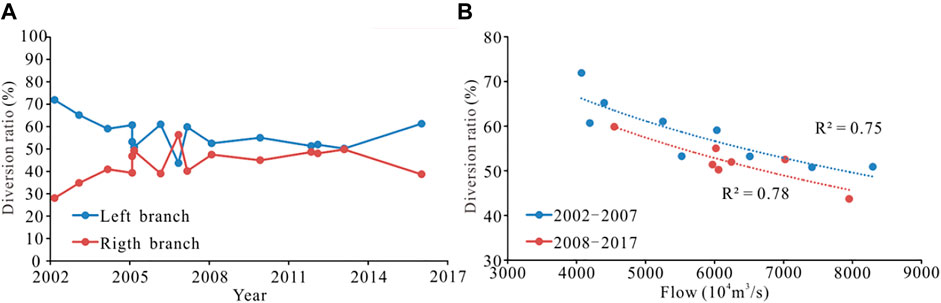
FIGURE 8. Split ratio of water of Lujiahe reach. (A) Split ratio of water; (B) Same flow to split ratio of water.
The planned waterway size of the Jingjiang reach is 4.5 × 200 m × 1,050 m, the weight of navigable ships being 5,000 t. According to the Changjiang River trunk line, the maximum speed of ascending rapids for the existing 5000-ton ships is 2.8 m/s and the maximum slope is 8‱. From 2005 to 2018, the maximum flow velocity of the Zhicheng–Changmenxi reach increased significantly, reaching a maximum of 3.50 m/s. In 2020, the maximum flow velocity was reduced to 3.28 m/s (Figure 9A, Figure 9C), which was still not conducive to the safety of ships; the vertical slope of the Zhicheng–Chenerkou reach was relatively small, the slope of the Chenerkou–Changmenxi reach having a significant increasing trend. Affected by the decrease in the split ratio of flow of the Songzikou, the increase in the split ratio of water of the right branch of the Lujiahe reach caused significant erosion of the branch, resulting in a weak hydrodynamic force on the left branch, resulting in the waterway water depth less than 4.5 m or the width being less than 200 m (Figure 9B).
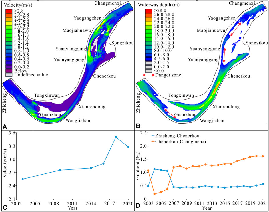
FIGURE 9. Hydrodynamic and waterway changes in shunt area of Songzikou; (A) Velocity distribution; (B) Water depth; (C) Maximum velocity; (D) Maximum gradient.
The erosion resistance of the riverbed of the right branch was higher than that of the downstream sandy riverbed, which meant the headward transmission effect due to the downstream water level drop was significant. Since 2007, the slope of the Changmenxi–Dabujie reach has been higher than 8‱ (Figure 9D), creating the phenomenon of “steep slopes and rapid currents,” which is not conducive to the safety of ships.
Waterway Conditions of Taipingkou Diversion Area
Relationship Between Branch Diversion and Main Waterway
During the dry season of 1975–2000, the flow diversion ratio of the north branch of the Sanbatan Central bar was higher than that of the south branch; thus, the main navigable waterway was located in the north branch (Figure 10). The flow diversion ratio of the north branch decreased during 2000–2003, after which a multi-phase waterway regulation project was implemented. From 2004 to 2012, the flow diversion ratio of the north branch exhibited an increasing trend, the desired flow diversion ratio being achieved through the waterway regulation project. Since 2013, the enlargement of the Yanglinji Beach, through silting, significantly narrowed the inlet of the north branch, rapidly reducing its flow diversion ratio from more than 60% in 2012 to approximately 15% in.
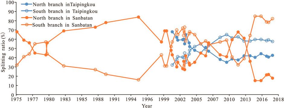
FIGURE 10. Relationship between the beach evolution and branch diversion ratio in the Taipingkou reach.
Since the implementation of Phase 1 of the Jingjiang Reach Waterway Regulation Project, the flow diversion ratio of the north branch was restored to some extent in 2016–2017, reaching 21.3% at the beginning of 2017, before decreasing to 17.8% by the end of 2017. Since the formation of the Taipingkou Central bar, the dry-season flow diversion ratio of the Taipingkou south branch has increased gradually, exceeding the flow diversion ratio of the north branch since 2004 and maintaining a level above 50% during 2004–2017. As shown by the flow diversion ratios, the Taipingkou south branch has been dominant over the north branch, making it appropriate to select the south branch as the main branch. The flow diversion ratio of the north branch of the Sanbatan Central bar has been higher than that of the south branch in most years; therefore, the north branch was usually selected as the customary main navigable waterway during the dry season, despite a slight decline in the flow diversion ratio in recent years. From 1955 to 2020, both the split ratios of water and the sediment ratio of Taipingkou were decreasing. Consequently, with the decreasing volume of sediment in the river basin, the south branch of Taipingkou developed a erosion trend. Since 2003, the 4.5 m waterway of the south branch of Taipingkou has been finished (Figure 10) and used as the main waterway during the dry season. Affected by sediment excavation activities in the north branch of Taipingkou since 2014 (Zhao et al., 2020; Yang et al., 2021), the north branch of Taipingkou has been greatly erosion and a 4.5 m waterway has been opened since 2018 as a dry-season waterway, forming a two-branch navigable route.
Morphological Changes of Beach
From 1955 to 1975, the split ratio flow and split ratio of water of the Taipingkou fluctuated. During this period, the scale of the Lalinzhou Beach was relatively large, and the central bars of Taipingkou had not yet formed (Figure 11). The 1975–1993 Taipingkou split ration of water by 29.3% compared with that from 1955 to 1975, which caused a relative increase in the runoff of the Jingjiang reach, causing the upper section of the Lalinzhou Beach to erode and separate, forming the Taipingkou central bars. From 1993 to 2008, the middle and upper sections of Lalinzhou Beach largely collapsed, corresponding to an increase in the area of the Taipingkou central bars, a great decrease in the area of Sanbatan, silting and erode of the upper section of Lalinzhou beach, and the silting up of its lower section. From 2008 to 2019, the area of the Taipingkou central bars and Sanbatan central bars exhibited a decreasing trend, the area of the upper section of Lalinzhou Beach being stable, and the area of the lower section exhibiting an increasing trend.
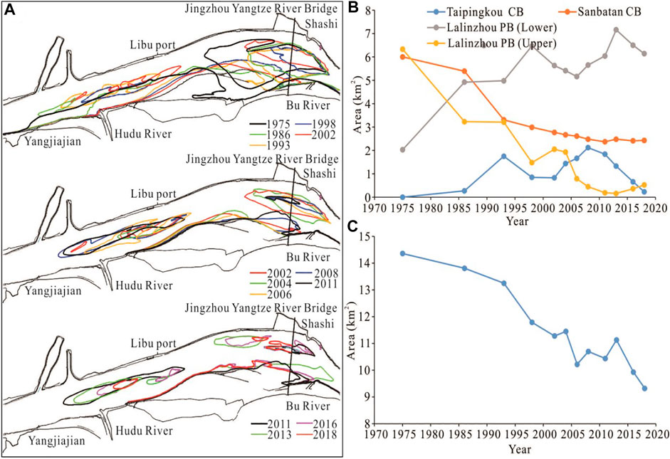
FIGURE 11. Shape and area of beach; (A) Beach evolution process; (B) Beach and Central bars area changes; (C and D) area variation.
Changes in Waterway Conditions
Since 2017, the water depth of the waterway in the Taipingkou reach has been maintained at 3.5–3.8 m, the planned water depth of the second-phase channel regulation project of the Jingjiang reach being 4.5 m. The water depth conditions of the 4.5 m waterway in the Taipingkou reach are checked based on the actual measured water depth contour from 1975 to 2018 (Figure 12A). The Taipingkou reach consists of four waterways: 1) Waterway 1, from the Taipingkou south branch to the Sanbatan south branch; 2) Waterway 2, from the Taipingkou south branch to the Sanbatan north branch; 3) Waterway 3, from the Taipingkou north branch to the Sanbatan north branch; and 4) Waterway 4, from the Taipingkou north branch to the Sanbatan south branch (Figure 12B). During 1975–2018 (Figure 12C), the 4.5 m water depth conditions gradually improved for waterways 1 and 2. Since 2011, a 4.5 m isobath has run unobstructed throughout Waterway 1, and since 2008 a 4.5 m isobath has run unobstructed throughout Waterway 2.
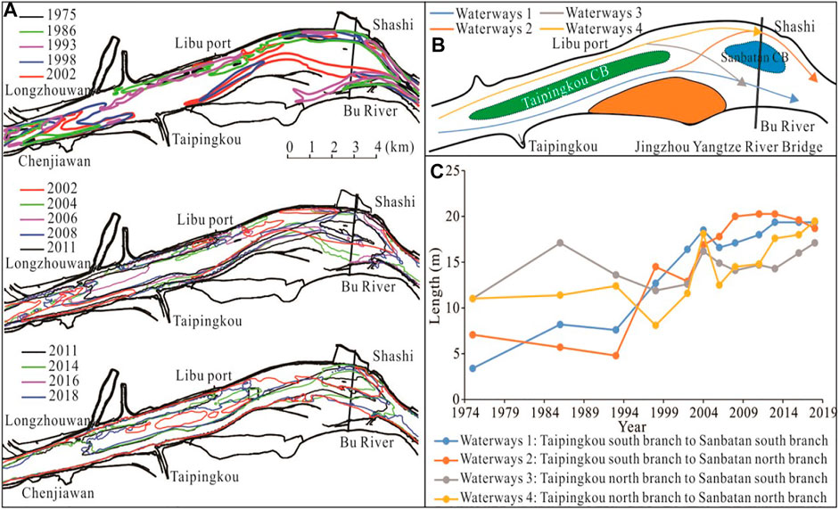
FIGURE 12. Waterway condition of the Taipingkou reach; (A) 4.5 m contour; (B) Route of waterway; (C) Length of 4.5 m isobath.
In terms of the waterway depth, the implemented waterway improvement project has achieved the expected goal, maintaining Waterway 2 as the main navigable waterway during the dry season. Since the implementation of the Three Gorges Project, the water depth conditions for the north branch have gradually improved as the river branches in the Taipingkou reach have been erode out, creating what is now the existing 4.5 m isobath throughout. Moreover, from the 2018 bathymetric survey map, a 4.5 m isobath has also developed throughout waterways 3 and 4.
Waterway Conditions of Ouchikou Diversion Area
With the decrease in the split ration of water at Ouchikou, the relative increase in the runoff of the Jingjiang reach has caused the collapse of the right edge of Tianxingzhou Central Bar and the erode of the upper section of the Tuoyangshu Beach, directly affecting the waterway conditions of the downstream reaches (Figure 13A). Since 2003, the right edge of Tianxingzhou has collapsed significantly. Shoreline protection was implemented during the first phase of the channel regulation of the Jingjiang reach, but the unprotected area still exhibited a collapsing trend, collapsing approximately 360 m from 2016 to 2019 (Figure 13B). From 2003 to 2019, the head of the Tuoyangshu Beach was headward erode and silted downstream at its lower end, squeezing the navigation channel, making the collapse of the Tokouyao Central Bars even more significant. From 2013 to 2017, the first phase of the channel regulation project of the Jingjiang reach was implemented, and the middle and lower sections of the Tuoyangshu Beach and the Tokouyao Central Bar were protected. However, the upper and middle section of the unprotected Tuoyangshu Beach was still in a state of erode and receding, scouring sediment downstream which silted up the navigation channel to form a silt-navigational-obstruction body.
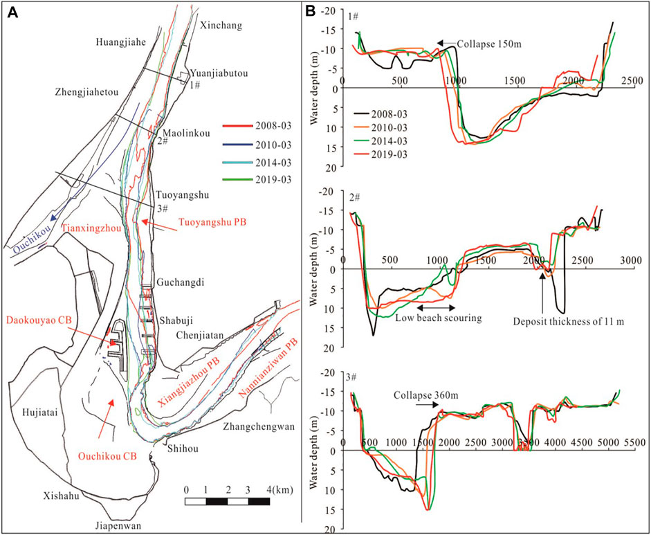
FIGURE 13. Changes of waterway and channel conditions in the confluence area of the Tianxingzhou–Ouchikou reach; (A) Length of 4.5 m isobath in the Tianxingzhou–Ouchikou reach; (B) Transverse section changes.
In 2017–2018, the riverbed scour in the Xinchang–Guchangdi reach was approximately 792 × 104 m3. The sediment transported downstream was prone to silt in the Ouchikou reach and needed to be dredged and maintained (Fan et al., 2020). With the decrease of the split ratio of water at Ouchikou, the collapse of the shoreline of Ouchikou and the receding of the head of the beaches have been aggravated (Jia et al., 2016). The unstable boundary of the waterways has created navigation obstruction problems, the siltation body formed by erosion causing the downstream water depth to be less than 4.5 m or the width to be less than 200 m.
Waterway Conditions in Confluence Area of Dongting Lake
From 2012 to 2020, the Xiongjiazhou–Chenglingji reach of the Dongting Lake’s confluence area showed “beach erosion on the convex bank and channel siltation on the concave bank” (Figure 14), consistent with the distribution characteristics from 2002 to 2012 (Zhu et al., 2016; Zhu et al., 2018). Affected by the operation of the Three Gorges Reservoir, the flow redistribution of the Lower Jingjiang reach during the year ensures that the beaches on the convex bank last longer in the mainstream area than the deep channel on the concave bank, increasing the erosion power of the beaches (Han et al., 2017). The erosion of the beaches on the convex bank of the curved river section causes the bending radius to decrease, making the channel bending radius insufficient and affecting the navigation safety of ships. The Xiongjiazhou–Chenglingji reach has continuous sharp bends, and the Xiongjiazhou, Chibakou, Baxianzhou, and Guanyinzhou reaches are affected by the jacking effect of the outflow of Dongting Lake (Lai et al., 2013; Sun et al., 2017). In 2012, the 4.5 m channel at the confluence of Dongting Lake and Jingjiang reach was disconnected. After the operation of the Three Gorges Reservoir, the river-lake hydrological jacking in the confluence area weakened (Yu et al., 2017; Liu et al., 2019; Duan et al., 2021), and in 2020, the 4.5 m channel in the confluence area of Dongting Lake and Jingjiang reach opened, only scattered shoals with a water depth of less than 4.5 m causing insufficient navigation width.
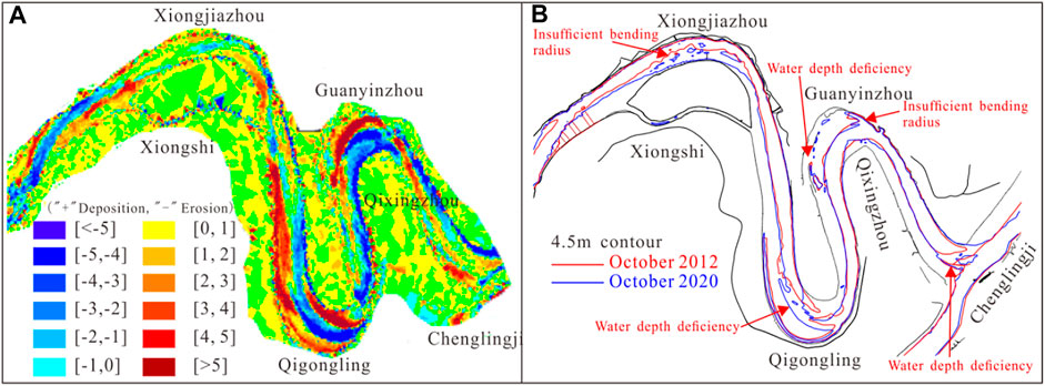
FIGURE 14. Water depth condition of the bend channel of the Xiongjiazhou–Chenglingji reach; (A) River bed erosion and deposition distribution; (B) Length of 4.5 m isobath in the Xiongjiazhou–Chenglingji reach.
Conclusion
This study took Dongting Lake and the confluence area of the middle reaches of the Changjiang River as the research object, analyzed the influence of the confluence relationship between rivers and lakes on the water depth conditions of the main channel of the Changjiang River, and further deepened the understanding of the navigation obstruction characteristics of the main channel of the Changjiang River.
After the operation of the Three Gorges Project (2003–2020), the Jingjiang reach (Zhicheng, Shashi, Jianli, Luoshan), the three outlets of Dongting Lake (Songzikou, Taipigkou, Ouchikou), and the Chenglingji Hydrological Station sediment of decreased by 79.45%–91.58%, 92.94%, and 55.8%, respectively, compared with conditions before the operation of the Three Gorges Project (1955–2002). The extent of runoff changes were −3.76 to 5.95%, −48.00%, and −13.80%, respectively, which has caused new changes in the river-lake relationship. Affected by the decrease in the volume of incoming sediment and the sediment content in the river basin, the Jingjiang reach has been eroded continuously since 2003, which has provided a favorable environment for the improvement of waterway conditions. The length of the Jingjiang reach not meeting the requirements of 4.5 × 200 m was 18.4 km, accounting for 5.3% of the total length of the reach. The Songzikou, Taipingkou, Ouchikou, and outlets of Dongting Lake had a navigation obstruction length of 12.6 km, accounting for 68.35% of the total length of the Jingjiang reach. The reach (Zhicheng–Dabujie reach) affected by the first outlet of Dongting Lake (Songzikou) exhibited the “steep slope and rapid current,” phenomenon, affecting the navigation safety of ships. Meanwhile, the downstream riverbed erosionr caused the water level to drop, and the waterway water depth was less than 4.5 m. The reach affected by the second outlet (Taipingkou reach) exhibited bottomland shrinkage, frequent alternation of branch channels, and extremely unstable dry-season navigation routes. The reach affected by the third outlet (Ouchikou reach) exhibited shoreline collapse, beach erosion, and oscillating movement. Furthermore, the channel boundary was unstable, making the downstream navigation width insufficient or producing shoals with a water depth of less than 4.5 m. The reach affected by the inflow into the Dongting Lake (the Xiongjiazhou–Chenglingji reach) was affected by jacking by the backwater outflow from the lake. The slowing of the flow in this reach caused scattered shoals with a water depth of less than 4.5 m in the navigation waterway.
Compliance With Ethical Standards
The contributing authors have no conflict of interest, including specific financial interests, relationships, or affiliations relevant to the subject matter or materials contained within this manuscript.
Data Availability Statement
The data and code for this study are available upon request from the corresponding authors.
Author Contributions
Full text written by YY; JZ put forward the research ideas; MJ, LY, WL, LZ, and others contributed to data processing and graph rendering.
Funding
This study was funded by the National Key Research and Development Program of China (2018YFB1600400; 2021YFB2600500), Fundamental Research Funds for Central Welfare Research Institutes (TKS20200404), Special Scientific Research Project of Changjiang Waterway Regulation (SXHXGZ-2020-4, QD20190608-4, GDYN20211102).
Conflict of Interest
The authors declare that the research was conducted in the absence of any commercial or financial relationships that could be construed as a potential conflict of interest.
Publisher’s Note
All claims expressed in this article are solely those of the authors and do not necessarily represent those of their affiliated organizations, or those of the publisher, the editors and the reviewers. Any product that may be evaluated in this article, or claim that may be made by its manufacturer, is not guaranteed or endorsed by the publisher.
References
Chen, M. F., Yao, W., Li, Y. T., Sun, Z. H., and Ba, Q. A. (2018). Contribution Rate for the Change of Diversion through the Three Outlets and its Response to the Three Gorges Reservoir Operation. China Rural Water and Hydropower (12), 116–121. doi:10.3969/j.issn.1007-2284.2018.12.023
Dai, M., Wang, J., Zhang, M., and Chen, X. (2017). Impact of the Three Gorges Project Operation on the Water Exchange between Dongting Lake and the Yangtze River. Int. J. Sediment Res. 32 (4), 506–514. doi:10.1016/j.ijsrc.2017.02.006
Dong, Z. F., Huang, B. B., Li, M., and Gao, K. C. (2020). Maintenance Dredging Technology of Lujiahe Waterway in Middle of the Yangtze River. Port Waterway Eng. 565 (1), 90–96. doi:10.3969/j.issn.1002-4972.2020.01.016
Duan, W., He, B., Chen, Y., Zou, S., Wang, Y., Nover, D., et al. (2018). Identification of Long-Term Trends and Seasonality in High-Frequency Water Quality Data from the Yangtze River basin, China. PLoS ONE 13 (2), e0188889. doi:10.1371/journal.pone.0188889
Duan, W., He, B., Nover, D., Fan, J., Yang, G., Chen, W., et al. (2016). Floods and Associated Socioeconomic Damages in China over the Last century. Nat. Hazards 82, 401–413. doi:10.1007/s11069-016-2207-2
Duan, Y. X., Li, J. B., Lv, D. Q., Wang, D. Y., Dai, W., and Liu, W. (2019). ianqing, et al. Hydrological Conditions and the Mutual Supporting Effects at the Intersection Area of Dongting Lake and Yangtze River Under the Operation of the Three Gorges Reservoir. Resour. Environ. Yangtze Basin 28 (10), 2471–2483. doi:10.11870/cjlyzyyhj201910019
Fan, W. T., Chen, Y., and Hu, Z. Q. (2020). Analysis on the Evolution and Maintenance Measures of Ouchikou Waterway from 2017 to 2018. China Water Transportation (Waterway Sci. Technology) 6, 1–7. doi:10.19412/j.cnki.42-1395/u.2020.06.001
Fang, C. M., Hu, C. H., and Chen, X. J. (2014). Impacts of Three Georges Reservoir’s Operation on Outflow of the Three Outlets of Jingjiang River and Dongting Lake. J. Hydraulic Eng. 45 (1), 36–41. doi:10.13243/j.cnki.slxb.2014.01.005
Geng, M., Wang, K., Yang, N., Qian, Z., Li, F., Zou, Y., et al. (2021). Is Water Quality Better in Wet Years or Dry Years in River-Connected Lakes? A Case Study from Dongting Lake, China. Environ. Pollut. 290, 118115. doi:10.1016/j.envpol.2021.118115
Grant, L., Vanderkelen, I., Gudmundsson, L., Tan, Z., Perroud, M., Stepanenko, V. M., et al. (2021). Attribution of Global lake Systems Change to Anthropogenic Forcing. Nat. Geosci. 14, 849–854. doi:10.1038/s41561-021-00833-x
Han, J., Zhang, W., Fan, Y., and Yu, M. (2017). Interacting Effects of Multiple Factors on the Morphological Evolution of the Meandering Reaches Downstream the Three Gorges Dam. J. Geogr. Sci. 27 (10), 1268–1278. doi:10.1007/s11442-017-1434-0
Han, Q., Zhang, S., Huang, G., and Zhang, R. (2016). Analysis of Long-Term Water Level Variation in Dongting Lake, China. Water 8 (7), 306–321. doi:10.3390/w8070306
Hu, G. W., Mao, D. H., Li, Z. Z., and Feng, C. (2013). Research Overview on the Influence of the Three Gorges Project Construction on Dongting Lake. J. Nat. Disasters 22 (5), 44–52. doi:10.13577/j.jnd.2013.0507
Hu, P., Lei, Y., Deng, S., Cao, Z., Liu, H., and He, Z. (2020). Role of Bar‐channel Interactions in a Dominant branch Shift: The Taipingkou Waterway, Yangtze River, China. River Res. Applic 37 (10), 494–508. doi:10.1002/rra.3761
Huang, Q., Sun, Z., Opp, C., Lotz, T., Jiang, J., and Lai, X. (2014). Hydrological Drought at Dongting Lake: Its Detection, Characterization, and Challenges Associated with Three Gorges Dam in Central Yangtze, China, Characterization,and Challenges Associated with Three Gorges Dam in Central Yangtze, China. Water Resour. Manage. 28 (15), 5377–5388. doi:10.1007/s11269-014-0807-8
Huang, S., Li, J., and Xu, M. (2012). Water Surface Variations Monitoring and Flood hazard Analysis in Dongting Lake Area Using Long-Term Terra/MODIS Data Time Series. Nat. Hazards 62 (1), 93–100. doi:10.1007/s11069-011-9921-6
Jia, D., Shao, X., Zhang, X., Lu, Y., and Hei, P. (2016). Morphological Responses in a Meandering and Island-Braided Reach of the Middle Yangtze River to the Three Gorges Reservoir Impoundment. Int. J. Sediment Res. 31, 131–138. doi:10.1016/j.ijsrc.2016.01.002
Jiang, J. H., Lai, H. J., and Huang, Q. (2007). The Characteristics of Flood Responses to the Restoration of Polders on Dongting Lake, China. Hydrological Sci. J. 52 (4), 671–685. doi:10.1623/hysj.52.4.671
Lai, X. J., and Wang, Z. M. (2017). Flood Management of Dongting Lake after Operation of Three Gorges Dam. Water Sci. Eng. 10 (4), 303–310. doi:10.1016/j.wse.2017.12.005
Lai, X., Jiang, J., Liang, Q., and Huang, Q. (2013). Large-scale Hydrodynamic Modeling of the Middle Yangtze River Basin with Complex River-lake Interactions. J. Hydrol. 492 (1), 228–243. doi:10.1016/j.jhydrol.2013.03.049
Lai, X., Liang, Q., Jiang, J., and Huang, Q. (2014). Impoundment Effects of the Three-Gorges-Dam on Flow Regimes in Two China's Largest Freshwater Lakes. Water Resour. Manage. 28 (14), 5111–5124. doi:10.1007/s11269-014-0797-6
Li, J. B., Zhou, Y. Q., Ou, C. M., Cheng, W. Y., Yang, Y., and Zhao, Z. H. (2013). Evolution of Water Exchange Ability between Dongting Lake and Yangtze River and its Response to the Operation of the Three Gorges Reservoir. Acta Geographica Sinica 68 (1), 168–177. doi:10.3969/j.issn.0375-5444.2013.01.012
Li, M., Hu, C. H., and Fang, C. M. (2021a). Study on Pattern and Mechanism of River Section Topography Adjustment in the Downstream of the Three Gorges Project. J. Hydraulic Eng. 49 (12), 1439–1450. doi:10.13243/j.cnki.slxb.20180205
Li, M., Hu, C. H., Zhou, C. C., and Peng, S. B. (2021b). Analysis on the Evolution Mechanism of The"steep Slope and Rapid Flow"section of Lujia Waterway in the Middle Reaches of the Yangtze River under New Conditions of Water and Sediment. J. Hydraulic Eng. 52 (2), 158–168. doi:10.13243/j.cnki.slxb.20200418
Li, Y., Li, B., Bing, L., Guishan, Y., and Rongrong, W. (2021c). Characteristics of Flow Change in Dry Season and Countermeasures of Songzikou River, a River-lake Connected Channel of Lake Dongting since 1960. J. Lake Sci. 33 (6), 1885–1897. doi:10.18307/2021.0622
Li, Y. T., Guo, X. H., Tang, J. W., and Sun, Z. H. (2009). Changes on Runoff Diversion from Jingjiang Reach of the Yangtze River to Dongting Lake after the Operation of Three Gorges Reservoir. J. Basic Sci. Eng. 17 (1), 21–31. doi:10.1109/MILCOM.2009.5379889
Liao, X. H., Zhu, F., Li, X. C., and He, F. Z. (2018). Research on the Channel Storage Characteristic of the Dongting Lake Based on Typical Year Flood. China Rural Water and Hydropower 5 (143), 134–137. doi:10.3969/j.issn.1007-2284.2018.05.027
Liu, L. S., Li, M., and Zheng, L. (2017). Evolution Mechanism of Sand and Gravel Braided Reach in Middle and Lower Yangtze River. Eng. J. Wuhan Univ. 50 (3), 346394. doi:10.14188/j.1671-8844.2017-03-005
Liu, Y., Li, J. B., Li, H., Yang, B., and Liu, W. (2019). Effect of the Three Gorges Reservoir Operation on Flood Inter-jacking in the confluence Section of Rivers and Lakes. J. Water Resour. Water Eng. 30 (2), 114–122. doi:10.11705/j.issn.1672-643X.2019.02.18
Lu, C., Jia, Y., Jing, L., Zeng, Q., Lei, J., Zhang, S., et al. (2018). Shifts in River-Floodplain Relationship Reveal the Impacts of River Regulation: A Case Study of Dongting Lake in China. J. Hydrol. 559, 932–941. doi:10.1016/j.jhydrol.2018.03.004
Mammides, C. (2020). A Global Assessment of the Human Pressure on the World's Lakes. Glob. Environ. Change 63, 102084. doi:10.1016/j.gloenvcha.2020.102084
Mao, D., Feng, C., Feng, C., Zhou, H., Hu, G., Li, Z., et al. (2017). The Runoff Variation Characteristics of Dongting Lake, China. Tecnol. Cienc. Agua 08 (2), 77–91. doi:10.24850/j-tyca-2017-02-08
Nakayama, T., and Watanabe, M. (2008). Role of Flood Storage Ability of Lakes in the Changjiang River Catchment. Glob. Planet. Change 63, 9–22. doi:10.1016/j.gloplacha.2008.04.002
Ou, C., Li, J., Zhou, Y., Cheng, W., Yang, Y., and Zhao, Z. (2014). Evolution Characters of Water Exchange Abilities between Dongting Lake and Yangtze River. J. Geogr. Sci. 24 (4), 731–745. doi:10.1007/s11442-014-1116-0
Sun, Z. H., Li, Q., Yan, X., and Luo, F. B. (2017). Analysis of the Critical Relationship between the Waterlevels of Dongting Lake and Chenglingji Station. Adv. Water Sci. 28 (4), 496–506. doi:10.14042/j.cnki.32.1309.2017.04.003
Wang, J., Sheng, Y., and Wada, Y. (2017). Little Impact of the T Hree G Orges D Am on Recent Decadal lake Decline across C Hina's Y Angtze P Lain. Water Resour. Res. 53 (5), 3854–3877. doi:10.1002/2016WR019817
Wu, Y., Xue, L., Liu, Y., and Ren, L. (2019). Uncertainty Assessment of Extreme Flood Estimation in the Dongting Lake basin, China. Hydrol. Res. 50 (4), 1162–1176. doi:10.2166/nh.2019.088
Xia, J., Deng, S., Lu, J., Xu, Q., Zong, Q., and Tan, G. (2016). Dynamic Channel Adjustments in the Jingjiang Reach of the Middle Yangtze River. Sci. Rep. 6, 22802. doi:10.1038/srep22802
Xia, J., Zhou, M., Lin, F., Deng, S., and Lu, J. (2017). Variation in Reach-Scale Bankfull Discharge of the Jingjiang Reach Undergoing Upstream and Downstream Boundary Controls. J. Hydrol. 547, 534–543. doi:10.1016/j.jhydrol.2017.02.026
Yan, J., Fu, Z. M., Chen, Q., Liu, Q. F., and Geng, J. L. (2012). River-Bed Evolution and Navigation Condition of Ouchikou Waterway in the middle Yangtze River. Port Waterway Eng. 462 (1), 99–104. doi:10.3969/j.issn.1002-4972.2012.01.021
Yan, T., Yang, Y.-p., Li, Y.-b., Chai, Y.-f., and Cheng, X.-b. (2019). Possibilities and Challenges of Expanding Dimensions of Waterway Downstream of Three Gorges Dam. Water Sci. Eng. 12 (2), 136–144. doi:10.1016/j.wse.2019.05.004
Yang, Y. P., Zhang, M. J., Sun, Z. H., Han, J. Q., and Wang, J. J. (2018c). The Relationship between Water Level Change and River Channel Geometry Adjustment in the Downstream of the Three Gorges Dam. J. Geographical Sci. 28 (12), 1943–1961. doi:10.1007/s11442-018-1575-9
Yang, Y. P., Zhang, M. J., Sun, Z. H., Li, H. G., and Li, K. Y. (2018b). Characteristics and Reason of Riverbed Evolution Difference in the Middle Yangtze River Based on River Unit Model. J. Basic Sci. Eng. 26 (1), 70–84. doi:10.16058/j.issn.1005-0930.2018.01.007
Yang, Y., Zhang, M., Liu, W., Wang, J., and Li, X. (2019). Relationship between Waterway Depth and Low-Flow Water Levels in Reaches below the Three Gorges Dam. J. Waterway, Port, Coastal, Ocean Eng. 145 (1), 04018032. doi:10.1061/(asce)ww.1943-5460.0000482
Yang, Y., Zhang, M., Zhu, L., Liu, W., Han, J., and Yang, Y. (2017). Influence of Large Reservoir Operation on Water-Levels and Flows in Reaches below Dam: Case Study of the Three Gorges Reservoir. Sci. Rep. 7, 15640. doi:10.1038/s41598-017-15677-y
Yang, Y., Zhang, M., Zhu, L., Zhang, H., Liu, W., and Wang, J. (2018a). Impact of the Operation of a Large‐scale Reservoir on Downstream River Channel Geomorphic Adjustments: A Case Study of the Three Gorges. River Res. Applic 34 (10), 1315–1327. doi:10.1002/rra.3372
Yang, Y., Zheng, J., Zhang, M., Zhu, L., ZhuWang, Y. J. J., Wang, J., et al. (2021). Sandy Riverbed Shoal under Anthropogenic Activities: The sandy Reach of the Yangtze River, China. J. Hydrol. 603, 126861. doi:10.1016/j.jhydrol.2021.126861
Yu, D. D., Yang, B., Li, J. B., Xu, M., and He, Z. (2017). Analysis on the Evolution Characteristics and Driving Factors of the Jingnan Three Port River Structure of Yangtze River in Recent 61 Years. J. Water Resour. Water Eng. 28 (4), 13–20. doi:10.11705/j.issn.1672-643X.2017.04.03
Yu, S. C., Yu, D. Q., Wang, L. C., Li, C. C., He, Q. H., and Xiang, F. F. (2019). Remote Sensing Study of Dongting Lake Beach Changes before and after Operation of Three Gorges Reservoir. Earth Sci. 44 (12), 4275–4283. doi:10.3799/dqkx.2019.182
Yu, Y., Mei, X., Dai, Z., Gao, J., Li, J., Wang, J., et al. (2018). Hydromorphological Processes of Dongting Lake in China between 1951 and 2014. J. Hydrol. 562, 254–266. doi:10.1016/j.jhydrol.2018.05.015
Zhan, L., Chen, J., Zhang, S., Huang, D., and Li, L. (2015). Relationship between Dongting Lake and Surrounding Rivers under the Operation of the Three Gorges Reservoir, China. Isotopes Environ. Health Stud. 51 (2), 255–270. doi:10.1080/10256016.2015.1020306
Zhang, C., Yuan, Y., Zeng, G., Liang, J., Guo, S., Huang, L., et al. (2016). Influence of Hydrological Regime and Climatic Factor on Waterbird Abundance in Dongting Lake Wetland, China: Implications for Biological Conservation. Ecol. Eng. 90, 473–481. doi:10.1016/j.ecoleng.2016.01.076
Zhang, D. D., Dai, M. L., Xu, G. H., and Deng, P. X. (2019). Research on Change of the Outflow of Dongting Lake during the Refill Period of the Three Gorges Reservoir. Adv. Water Sci. 30 (5), 613–622. doi:10.14042/j.cnki.32.1309.2019.05.001
Zhang, M., Feng, X. X., Liu, Z., and Li, W. J. (2015). Impact on Dongting Lake Channel Caused by the Change of Flow and Sediment Environment after Three Gorges Project Impoundment. Adv. Water Sci. 26 (3), 423–431. doi:10.14042/j.cnki.32.1309.2015.03.013
Zhang, Y., Lai, X., Zhang, L., Song, K., Yao, X., Gu, L., et al. (2020). The Influence of Aquatic Vegetation on Flow Structure and Sediment Deposition: A Field Study in Dongting Lake, China. J. Hydrol. 584, 124644. doi:10.1016/j.jhydrol.2020.124644
Zhao, W. Y., Yang, Y. P., Zhang, H. Q., Zhang, M. J., Yuan, J., and Yang, B. C. (2020). Adjustment Patterns and Causes of the Morphology of sandy Riverbed Downstream of the Three Gorges Dam. Adv. Water Sci. 31 (6), 862–874. doi:10.14042/j.cnki.32.1309.2020.06.006
Zheng, S. R. (2016). Reflections on the Three Gorges Project since its Operation. Engineering 4 (2), 389–397. doi:10.1016/j.eng.2016.04.002
Zhou, Y., Jeppesen, E., Li, J., Zhang, Y., Zhang, X., and Li, X. (2016). Impacts of Three Gorges Reservoir on the Sedimentation Regimes in the Downstream-Linked Two Largest Chinese Freshwater Lakes. Sci. Rep. 6, 35396. doi:10.1038/srep35396
Zhou, J. J., and Zhang, M. (2018). Effect of Dams on the Regime of the Mid-lower Yangtze River Runoff and Countermeasures. J. Lake Sci. 30 (6), 1471–1488. doi:10.18307/2018.0601
Zhu, L. L., Xu, Q. X., and Chen, Z. H. (2018). Extraordinary Scour of Jingjiang Reach Downstream from Three Gorges Project. J. Basic Sci. Eng. 26 (1), 85–97. doi:10.16058/j.issn.1005-0930.2018.01.008
Keywords: Changjiang River waterway, Dongting Lake, deep-water resources, navigation safety, shipping, river-lake confluence, obstructed navigation
Citation: Yang Y, Liu W, Zhang J, Yang L, Jia M and Zhu L (2022) Changes of Divergence and Confluence Relationship Between Dongting Lake and the Yangtze River After the Operation of the Three Gorges Project and Its Impact on the Waterway Depth. Front. Earth Sci. 10:829669. doi: 10.3389/feart.2022.829669
Received: 06 December 2021; Accepted: 14 January 2022;
Published: 10 February 2022.
Edited by:
Xijun Lai, Nanjing Institute of Geography and Limnology (CAS), ChinaReviewed by:
Weili Duan, Xinjiang Institute of Ecology and Geography (CAS), ChinaPingping Luo, Chang’an University, China
Copyright © 2022 Yang, Liu, Zhang, Yang, Jia and Zhu. This is an open-access article distributed under the terms of the Creative Commons Attribution License (CC BY). The use, distribution or reproduction in other forums is permitted, provided the original author(s) and the copyright owner(s) are credited and that the original publication in this journal is cited, in accordance with accepted academic practice. No use, distribution or reproduction is permitted which does not comply with these terms.
*Correspondence: Yunping Yang, eWFuZ3NhbjUyMF81MjFAMTYzLmNvbQ==; Jie Zhang, emhhbmdqaWVAdGl3dGUuYWMuY24=