 Wanfeng Liu1
 Huyuan Zhang
- 1College of Civil Engineering, Longdong University, Qingyang, China
- 2College of Civil Engineering and Mechanics, Lanzhou University, Lanzhou, China
- 3Key Laboratory of Mechanics on Disaster and Environment in Western China, Lanzhou University, Ministry of Education, Lanzhou, China
Loess tablelands are large-scale platforms with flat top surfaces in the center of Chinese Loess Plateau, such as Dongzhiyuan, which is a ∼900 km2 loess stratum, with the thickness larger than 200 m. The break of loess tablelands is widely reported due to the retreat of gully systems, resulting in serious social problems and economic losses. The retreating rate of large gullies has been 0.5–6.6 m/year over the past 2,000 years, estimated by the calculation of erosion modulus, literature archaeology, and field monitoring. The retreating rate of a small gully can reach 7.5–27.0 m/year after a rainstorm. To protect the farmland, buildings, roads, and pipelines near to the gully head areas, a project named Gully Stabilization and Highland Protection (GSHP) was launched by the local government, including the small watershed management (SWM) around loess slopes and gully channels and sponge city construction (SCC) achieved by improving the drainage system of tableland surfaces. These efforts improve the soil and water conservations, although they contribute less to controlling gully expansion. From the perspective of mutual promotion of gravity erosion and hydraulic erosion, this paper proposes a technical framework for GSHP, focusing on the avoidance of geological disaster. This case study reports on an illustrative GSHP project, the restoration of Huoxianggou gully, including the backfilled loess embankment across the gully for convenient urban transportation, and the stabilization of unstable loess slopes. After the implementation, the retreat of the gully head has been stopped, and the soil erosion rate has been reduced by 90%.
Introduction
A loess is a loose aeolian deposit of yellowish silt-sized dust, mostly formed during the Quaternary period (Liu, 1965; Liu, 1985). Loess deposits are widespread in China, which is mainly along the middle reaches of the Yellow River in central China and is called as the Chinese Loess Plateau (Figure 1) The thickness of loess sediments can be as large as several hundred meters. Dongzhiyuan loess tableland is an example, where there is a specific geometrographic unit with broad and flat top surfaces surrounded by deep gully systems, at Xifeng District of Qingyang, Gansu Province, China (Figure 2).
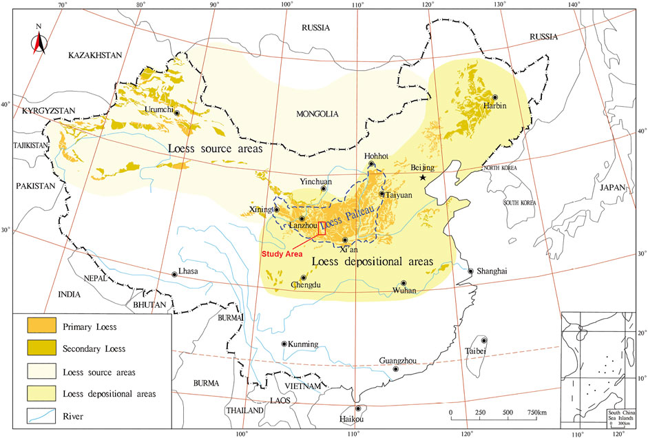
FIGURE 1. Loess distribution and the Chinese Loess Plateau (Li et al., 2018).
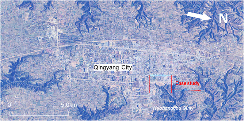
FIGURE 2. Loess tableland of Dongzhiyuan eroded by gullies.
During the rainy season, the huge flat surface of the loess tableland receives intense precipitation, and flood water discharges into the gullies. Serious erosion is found on the gully head, bed, and side slopes. Also, the gully heads have expanded quickly towards the central tableland, resulting in a shrinkage of the tableland. This process was speeded up due to the urbanization of Qingyang City at the center of the loess tableland of Dongzhiyuan. The shrinkage of the tableland limits urbanization and economic development, which is the biggest challenge for the local government.
To solve this problem, the local government consulted, with an open mind, various experts, such as experts in Quaternary geology, soil and water conservation, geological hazard prevention, meteorology, water conservancy, and urban planning. The preliminary consensus was that gully expansion is a natural process but has been speeded up by human activity in recent years. Gully heads are extremely sensitive to hydraulic scouring and piping erosion during rainfalls, which cause rapid retreat of the radial gully system on the tableland margin. Geotechnical engineering measures are recommended by experts to stabilize gully head and improve the local soil and water conservation. Geological disaster control has become a priority for reducing both gravity and hydraulic erosions. This technical idea has been summarized as Gully Stabilization and Highland Protection (GSHP), hereafter referred to as the GSHP project. Until now, the major engineering measures in the GSHP project includes backfilling, drainage, slope stabilization, and ecological slope protection (Huo et al., 2020). Based on hydrological modeling of typical watershed and field observations, the GSHP project has clearly reduced the surface runoff and sediment (Huo et al., 2021). This paper summarizes the major opinions that emerged during the initial stages of the GSHP project and proposes a technical framework for selecting effective engineering measures in practice.
Breaking Up of Loess Tableland by Gully Erosion
Landforms refer to various forms of the Earth's surface that result from internal and external geological processes over time. Geomorphology divides loess landforms into three main types: the tableland, ridges, and hillocks. Loess tableland is a geomorphic unit developed at the end of the Tertiary with a large area and a flat top, which was later eroded due to uplift (Zhang, 1983). It is considered that homogenous loess deposits masked the underlying bedrocks and therefore inherited a flat top surface (Tsunekawa et al., 2014; Li et al., 2020).
The loess tableland of Dongzhiyuan is the most intact and the largest tableland in the world with a loess thickness of 150–200 m. Originally, the tableland was recorded as being more than 110 km long (north to south) and about 50 km wide (east to west). Because of the serious soil erosion, there are now just 89 km left (north–south) and 46 km east–west. Approximately 756–1,344 km2 of the tableland retreated in the past 1,000 years, nearly 1 km2/year (Derbyshire, 2001).
The huge tableland has a flat surface generally with 1–3° inclination, which was renowned as being a granary in the 1980s because of the abundant grain harvest in Gansu Province. There are seven large gully systems around the tableland in a radial formation (Figure 2). The gully heads are only ∼50 m apart in some locations, and they are tending to split the tableland into two parts, owing to the rapid erosion in the past few decades.
After a rainfall, flood water converges from the tableland surface and pours down with silt, washing away the fertile soil and leaving behind the barren land. The whole tableland surface is being continuously cut and shrunk year on year. The most recent investigation recorded 37 gullies of different sizes surrounding the tableland margin. On the tableland edge area 50 m away from the gully heads, there are 27 schools, 5,384 households, and more than 200 buildings, which are directly threatened by gully head expansion. Therefore, tableland protection is a huge challenge for the local government to protect both the local residents and the economic development.
Gully Expansion From a Geological View
Geologically, Loess Plateau on a regional scale inherits the basic morphological characteristics of ancient landforms because loess has covered the underlying bedrock in geological history, but the relative height difference is smaller than that of the ancient topography (Li et al., 2018).
Geomorphology describes the evolution process of a river valley from the principle of “erosion basis.” The downward erosion of a valley does not cease until the valley reaches the base level of erosion. On the loess plateau, the bed channels of the gullies are usually higher than the local erosion basis, resulting in continuous downward erosion in the last thousand years.
The gullies that formed during the geological period are referred to as ancient erosion gullies, while the gullies that have formed onto the slope of ancient erosion gullies since the Holocene are referred to as modern erosion gullies. The former gullies are mainly distributed at the lower reaches of the gully system, characterized by a wide channel and a typical U-shaped cross section. The latter are mainly distributed at the upper reaches of the gully system as the modern gully heads, characterized by a narrow and deeply grooved channel and a typical V-shaped cross section.
Statistics of Gully Head Expansion
Using the methods of archaeological investigation and historical literature research, Shi (1999) investigated the geomorphologic age of the Loess Plateau. Shi (1999) estimated that the original loess tableland began to be broken no earlier than 2,000 years ago, and the main destruction occurred in the Chinese Sui and Tang Dynasties (AD 907). This means that the river valleys and large gullies around the loess tableland have existed for at least 1,000 years. Shi (1999) mentioned that modern erosion continuously carved the tableland, resulting in longer, deeper, and wider gullies than ever before.
Based on the methodology established by Shi (2001), Yao (2009) made a new attempt to quantify the extension of gullies. Gullies are simplified as triangular pyramids, which can be enlarged equally and uniformly during historical erosion. The enlarged gullies are supposed to be originally filled by the soil eroded away, which can be calculated by the erosion modulus of the gullies. Assessment results indicated that 77 typical gullies around the Dongzhiyuan Tableland expanded their head toward the upstream direction with a rate between 0.45 and 6.56 m/year in the last 2,000 years. Typical results of the nine gullies with complete watersheds are named A series and are reported in Table 1.
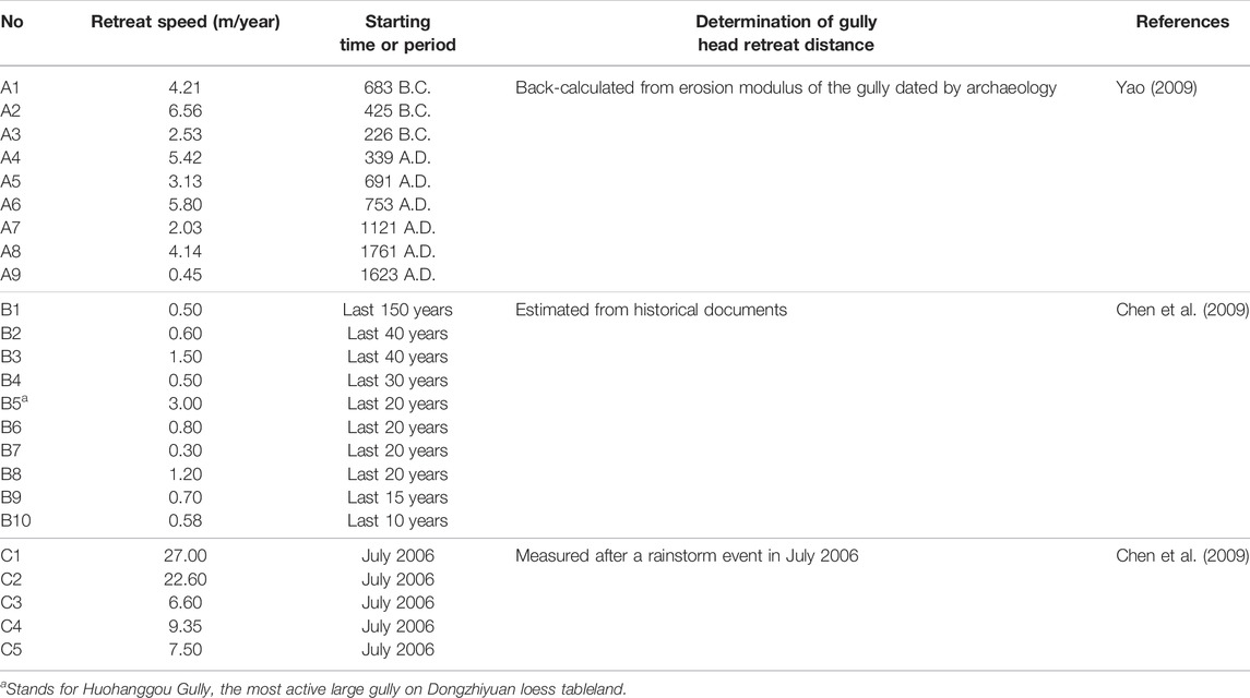
TABLE 1. Speed of gully head retreat estimated by different methods.
Table 1 also lists the head retreat speed of several gullies in the recent past, as estimated by Chen et al. (2009). The gully expansion of the B series was estimated from historical records, while the gully expansion of the C series was determined by field measurement after a single rainstorm event. Small gullies of the C series retreated 7.5–27.0 m/year after a rainstorm event. In contrast, the big gullies of the B series tended to be stable over a long period if rainwater flood seldom discharged into the gullies. For example, these kinds of gullies extended 0.3–3.0 m/year during 10–150 years.
It should be noted that the retreat of gully head highly depends on the discharge of rainwater flooding. Fast retreat of a gully results from not only intensive scouring erosion but also the increasing height of the newly formed slope. The newly formed slope prompts potential gravitational erosion, such as rockfall and slope slide. Therefore, scouring erosion plays a critical role in the retreat of gullies.
Huohanggou Gully has been recognized as the number one threat to the urban safety of Qingyang City because of its fast penetration into the downtown area. In 1949, a Yellow River investigation team measured the gully expansion and reported that this gully had retreated at least 300 m from 1889 to 1949, or 5 m/year. According to the data of Chen et al. (2009) as indicated by B5 in Table 1, this gully has retreated 3 m/year over the last 20 years after a stormwater pond was constructed in 1952 at the gully head area.
Mechanism of Gully Head Retreat
Gully erosion is an advanced stage of rill erosion, which makes the rills wide and deep. Continuous undercut results in collapse of the gully head and triggers the upslope extension of most of the gullies. Also, the slumping and collapsing of the sidewalls contribute to a higher proportion of soil loss (Shit et al., 2020).
A headcut refers to a sudden step change in the bed elevation of a gully channel, and intense erosion occurs at this site due to the jet flow scouring from the upstream area (Bennett, et al., 2000). Gully headcut erosion is caused by a complicated process, including plunge pool erosion, headwall erosion, pore water pressure change, tension crack development, and mass failure (Vanmaercke et al., 2016). Headcut erosion mainly depends on the area of the upstream catchment and rainfall characteristics, such as the rainfall intensity and slope topography (Bennett, 1999).
The three-dimensional features of a modern erosion gully can be described simply by three geometric parameters: the length, top width, and depth of the gully. If the changes in geometric parameters are recorded, the gully expansion can be classified simply by the maximum increasing parameter. Thus, the erosion of a gully can be predominated by head retreat, widening, or deepening. Much more detailed investigations indicate that modern erosion gullies are expanded by rapid retreat of the gully head rather than widening or deepening.
For erosion gullies, five different types of loess erosion can be distinguished from a gully profile (Zhang, 1980, Figure 3): (I) sheet and/or rill erosion zone, (II) subsurface piping erosion zone, (III) incising erosion zone, (IV) gravitational erosion zone, and (V) scouring erosion zone. Simply speaking, sheet erosion is dominant at the upper part of the slope, while gravitational erosion occurs mainly at the middle of the slope, and underground piping erosion occurs at the toe of the slope. Vertical scouring erosion occurs mainly in the gully bed by deepening and extending the gully into the loess hillside and finally creating head cuts and steep banks.
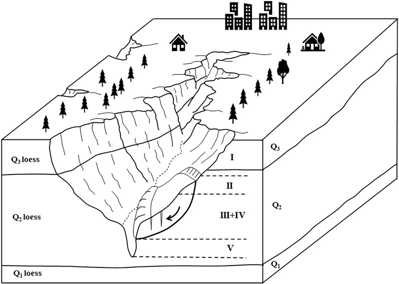
FIGURE 3. Zonation of erosions at upstream of loess gully (modified from Zhang, 1980). I, sheet erosion zone; II, subsurface piping erosion zone; III, incising erosion zone; IV, gravitational erosion zone; V, scouring erosion zone).
The development of gullies has a negative impact on engineering construction, especially road construction. When a route passes through the gully area, backfilling and erecting bridges crossing deep ditches are required. Subgrades are often damaged due to the development of gullies. For example, in Northwest China, after a rainstorm, many new gullies will be formed, and the existing gullies will be lengthened for several meters, resulting in the damage of subgrades.
Generally, the development of gullies can be divided into four stages, i.e., rill and cutter stage, headcut stage, balanced section stage, and stopping development stage. It should be pointed out that the whole process of gully development is, in fact, continuous. The main significance of stage division is to choose approximate control measures.
At the first stage, local surface water is concentrated in a small concave part of the slope and begins to wash out, forming a shallow cutting ditch of about 30–50 cm. The longitudinal section of the shallow trench is roughly the same as that of the slope with a triangular cross section. At the second stage, falling water or a steep cliff is formed at a height usually of 2–10 m, sometimes up to 10–15 m. Under the wash of running water, the gully head continuously retreats in the watershed direction. At the same time, the gully bottom is rapidly incised and deepened to 25–30 m. At the third stage, the gully mouth reaches the local erosion base level, such as the river surface or terrace. The longitudinal section of the trench bottom is close to the “balance section.” Before the equilibrium section is reached at the third stage, intensive erosion continues to cut down, and the slopes on both sides continue to collapse. At the fourth stage, the gully bed approaches the “equilibrium section.” The undercutting stops, and the headcut becomes more and more gentle, so the gully is no longer lengthened. Sediments appear at the gully bottom, and gully slopes collapse gradually until a naturally stable condition is reached. Plants grow on to the sediments or the side slopes surface.
Suitable spillway structures are suggested by Shit et al. (2020) to control gully head (Table 2). It is clear that a pipe spillway has a good adaptability to different overfalls or head steps, which is characterized by low cost and less maintenance.
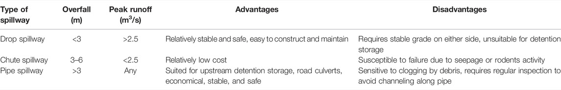
TABLE 2. Suitability of different spillways as gully head control structure (Shit et al., 2020).
Strategies and Measurements for the GSHP Project
The aims of the GSHP include measures to prevent the erosion of the loess highland from a practical perspective and an integrated technical system from an academic perspective for selection of effective engineering measures to prevent gully head expansion.
Various measures have been practiced for soil and water conservation in Chinese Loess Plateau, in fact, from different disciplines, such as small watershed management (SWM), geological disaster control (GDC), and sponge city construction (SCC). The different disciplines have different emphases when dealing with soil and water conservation. After 70 years of practice, several measures have been confirmed to be effective in controlling the shrinkage of Dongzhiyuan loess tableland. Strategies and major measures for GSHP are listed in Table 3, and a framework of core technical measures is indicated in Figure 4. Mitigation measures are recommended to be scheduled following the steps: first stormwater regulation, then gully head stabilization, and finally the soil and water conservation on gully slopes and channels.
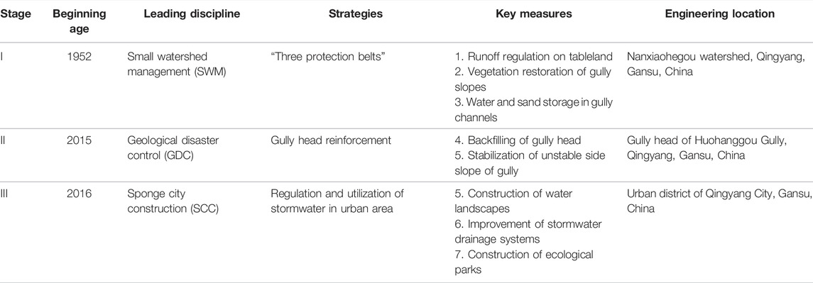
TABLE 3. Strategies and measurements of the GSHP project.
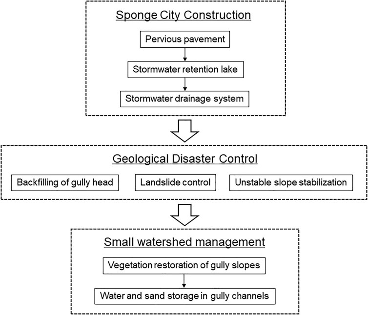
FIGURE 4. The framework of the GSHP project.
Practical protection of the loess tableland started in 1952, when a soil and water conservation agency was established in the central Dongzhiyuan Tableland, Qingyang City, Gansu Province, China. Therefore, early measures, at stage I, focused on passive control of soil and water in the gully channel and on the sides of the slopes. At stage II, innovation shifted to active protection—geotechnical stabilization of gully heads or side slopes. Stage III is characterized by SCC, which paid close attention to regulation and efficient utilization of rainwater on the tableland surface. Artificial lakes were constructed for stormwater retention or storage. A stormwater drainage system was specially designed to deliver the overflowing water down to gully beds.
Strategies From Small Watershed Management
Soil erosion studies have traditionally been conducted in single watersheds or at a regional scale using aerial photographs or field survey methods (Vanmaercke et al., 2016). In 1952, Xifeng Soil and Water Conservation Experimental Station was established in a watershed at Dongzhiyuan Tableland. Based on statistical data and successful erosion control on loess slopes, approximately 63% of the total runoff was generated from loess tableland, which contributed 86.3% of the total eroded sediment in watersheds (Guo et al., 2018). From successful practice in single watersheds, three “protection belts” were suggested as major reclamation areas in GSHP project. This emphasized the runoff regulation on tableland, vegetation restoration on slopes, and water and sand storage in gully channels for controlling serious erosion of the loess tableland. When the steep slope is converted into terrace forest and grassland, the erosion of coarse sediment into the Yellow River can be effectively reduced (Zhao et al., 2013). Actually, vegetation restoration plays an important role in the reformation of scattered rills, shallow gullies, or even cutter gullies on slopes because the root systems provide additional cohesion and shear and tensile strength (De Baets et al., 2008).
Strategies From Geological Disaster Control
A gully head is characterized by discrete steps, i.e., the sudden change in the elevation of a gully channel. If rainfall intensity exceeds a certain threshold, the gully head will move in upstream direction because of intense jet flow scouring, tension crack development, and mass failure. It was found that gully head retreat was caused by flow incision, headwall erosion, and gully bank collapse (Dong et al., 2019). In other words, large-scale gullying is closely related to geological disasters, such as mudflows, rockfall, and landslides. Geological disasters and gravitational erosion destroy the root systems, limiting the vegetation restoration effects. Therefore, gully head stabilization becomes a primary concern for establishing a base for further vegetation restoration.
In addition to the “three protection belts,” close attention was paid to gully head stabilization, and the GSHP project was moved to its second stage. At this stage, four “protection belts” were designated as the reclamation target for the GSHP project, i.e., four landform units of tableland, gully heads, slopes, and gully channels. Specifically, reclamation included runoff regulation on the tableland, reinforcement of the gully head, vegetation restoration on slopes, and water and sand storage in the gully channels.
Geotechnical engineering plays a critical role in stabilization of landslides and unstable slopes and the backfilling of eroded sinkholes in gully head areas. Additional equipment must be provided to discharge rain flood down to the gully beds. Shit et al. (2020) analyzed the suitability of different types of spillways as gully head control structures. A pipe spillway is suitable for any gully head height and any peak flood discharge and capable of upstream detention storage or road culverts.
Strategies From Sponge City Construction
Qingyang City has suffered from limited precipitation, water resource shortage, and urban waterlogging over a long period of history. Especially in recent years, increasing rainwater is discharged down to the tableland, which has resulted in intensive erosion of gullies around the tableland due to rapid urban expansion and urban plot surface hardening.
In 2016, Qingyang City joined a demonstration program of the Sponge City project in China. Sponge City is a new design concept in China for urban planning based on the low impact development (LID) principle (US EPA, 2000). The major emphasis of the LID requirements in municipal permits is the reduction of impervious areas in order to facilitate infiltration and reduce urban runoff for specified categories of new development and redevelopment projects.
New stormwater pipelines were constructed in Qingyang City to capture rainwater from tableland surface, and artificial lakes were constructed to collect stormwater for ecological usage. As a result, both volume and peak runoff were reduced, and the intensive headcut of gullies was successfully controlled. Ecological parks were planned as recreational areas for citizens, such as the forest park in Huohanggou Gully, the wetland park in Zhangtiegou Gully, and the geological park in Xiaokongtong Gully.
SCC is characterized by practical collection and regulation of stormwater from tableland surface, improving the utilization of water resources. The implementation of the sponge city project is considered to have promoted the GSHP project into its third stage. During this stage the GSHP project has provided active measures controlling the intense erosion at the gully head by the stormwater from the tableland surface.
Case Study of Gully Head Stabilization
Huohanggou Gully, as a natural ditch, has served as an urban drainage channel for a period of long history, discharging rain flood from the downtown area in Qingyang City to the gully bed. Since the 1940s, this gully threatened the safety of city streets. Table 4 lists a brief history of the major hazardous events, such as fast head penetration into city blocks and landslide and the major mitigation measures. Since 2017, large-scale engineering has been conducted to control geological hazards in the gully head area, including both backfilling of the gully head and stabilization of unstable side slopes. No retreat of the gully head has been observed since the reclamation. This is of important academic value for the GSHP project to set up appropriate statutory mitigation measures.
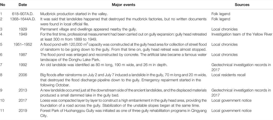
TABLE 4. Major hazardous events and rehabilitation of the Huohanggou Gully.
The elevation of the gully head approaching loess plateau is 1,400 m, and the gully bed is 1,284 m. The 116 m difference between the elevation of the head and the bed covers 300 m of the plateau. Meteorological data show that the average annual rainfall is 540 mm, mainly occurring from July to September. The largest single rainfall event reached 200 mm, about 40% of the average annual rainfall. The maximum flood was estimated at 4,000 m3 according to the drainage area of 20 km2 based on local topography. The average flood flow into Huohanggou Gully was 30–50 m3/s, and the peak flow was 500 m3/s based on the hydrological observation. It is obvious that rain floodwater discharged into the gully without regulation possesses a huge amount of energy to intensively erode the gully bed and side slopes.
Figure 5 provides an overall impression of the GSHP conducted in Huohanggou Gully. The Donghu Lake Park is a beautiful park now, where a large flood pond was firstly dug on the tableland surface in the 1950s, and reconstructed in 1987 using concrete in the same position, for collecting stormwater from the nearby urban area as indicated by arrows in Figure 6. Next to the Donghu Lake Park on the east side, there is a backfilled high embankment at the gully head area as the foundation of a main street crossing the gully. Next to the north side of the backfilled embankment are the stabilized loess slopes. Figure 7 shows the layout and the detailed structure of the embankment. Representative sections as shown in Figure 6 will be presented subsequently.
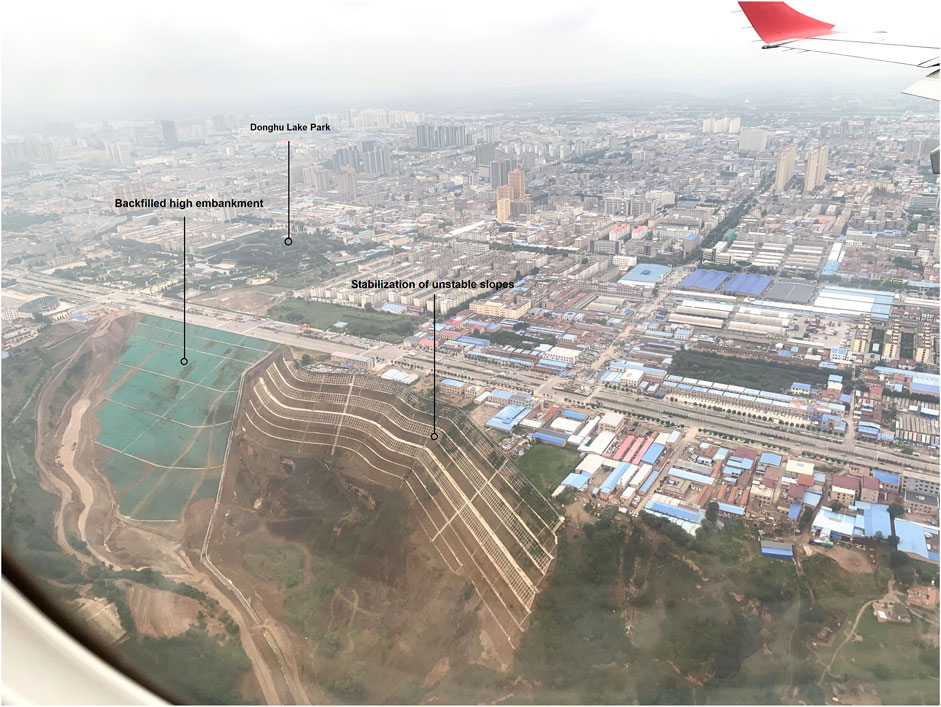
FIGURE 5. Geohazard control engineering at Huohanggou Gully as seen from an airplane.
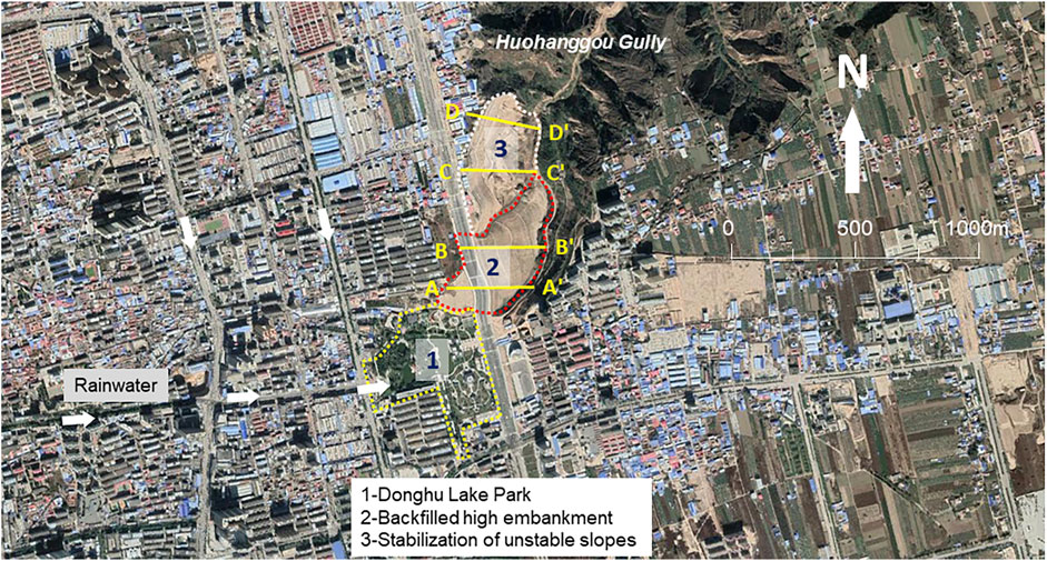
FIGURE 6. Layout of geohazard control engineering at Huohanggou Gully. A—A’, B—B’, C—C’, and D—D’ are section lines.
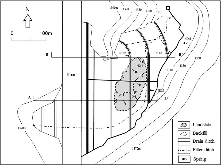
FIGURE 7. Layout of the backfilled high embankment. A—A’ and B—B’ are section lines.
Backfilled High Embankment
The loess strata contain horizontally continuous paleosols, which become the impermeable floor of the phreatic aquifer in the Loess Plateau area. This aquifer is generally a few meters in thickness, and widely distributed, collecting drinking water used by local farmers over a long period of history. When the gully is cut down to the paleosol layer, spring water from the aquifer is exposed as four natural springs at the gully bed, which have wetted and eroded the toe of the side slopes and triggered three landslides.
Huohanggou Gully is a typical gully closely related to the disasters in the Loess Plateau: strong flood erosion coexisting with landslide at the head of the gully area. The characteristic features include the following three aspects: First, the upper reaches of the valley are rich in recharge of floodwater. With the acceleration of urbanization, especially the increase in impervious surface area, even under the same rainfall conditions, the flood peak tends to increase year on year. Second, the gullies have a larger longitudinal grade, with high potential for flood erosion and destruction. Third, the ditch slopes are steep and the foot of the slope is soaked and washed by the groundwater overflow, so landslide hazards occur.
From the perspective of traffic engineering only, it may be more economical to use a bridge to cross the gully for an urban road. If this kind of plan is adopted under a philosophy of “out of mind, out of thinking,” the gully head will invade into the city, and serious urban problems will be passed on to the following generations.
The local government selected an expensive scheme, a high-fill embankment after a variety of comparisons and demonstrations. This scheme has comprehensive benefits: The backfilled embankment is arranged along the road axis to solve the traffic problem; the high embankment reinforces the steep slopes on both sides of the gully; the drainage system is set up inside the embankment to manage the flood and block the ditch head erosion. This case is not only a road promotion project but also a typical gully stabilization project. Figures 8 and 9 give representative section profiles, indicating the backfilled area and the original landform.
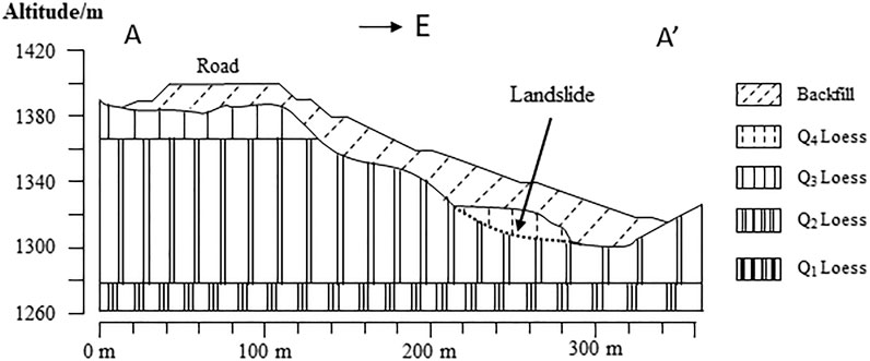
FIGURE 8. A–A′ profile across the high backfill embankment.
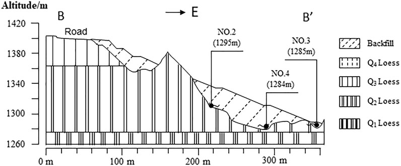
FIGURE 9. B–B′ profile across the high backfill embankment.
The major embankment was backfilled by compacted loess soil layer by layer. It was designed according to the standard of urban main road, with a maximum width of 60 m, eight lanes in two directions, opening up a main road for this city. At the same time, the embankment was equipped with an integrated trench, in which rainwater pipes, sewage pipes, and water supply pipes were installed at the same time. As a result, dual purposes have been achieved from the backfilled embankment, gully head stabilization, and the throughput of traffic.
Stabilization of Unstable Slopes
Groundwater is the main factor affecting the landslides in Huohanggou Gully. On the one hand, groundwater has eroded the slope toe for a long time, making the gully slope steeper, and on the other hand, the existence of groundwater greatly reduces the shear strength of the soil, and these results in the reduction of effective normal stress and friction resistance due to the hydrodynamic pressure. In addition, the height difference between the slope top and ditch bed is more than 100 m, and the gradient is 30–70°. The high, steep terrain is the most vulnerable topographic condition for the formation of landslides. Buildings on the slope top have created additional load for a potential landslide. Tillage has also continuously destroyed the natural vegetation, resulting in elevated infiltration of precipitation.
Based on an analysis of the landslides, comprehensive treatment measures were proposed, including slope cutting, surface water interception and drainage, and ditch backfilling. Figures 10 and 11 give representative profiles of the slope cut and the original landform. Firstly, the buildings on the slope top were relocated. Then, the slope was cut into eight steps, reducing the down-sliding force on the slope body, and stabilized by anchor lattice beam technology. Drainage channels were constructed on each platform to prevent the surface water from infiltrating into the slope body. The large amount of earth cut from the original slope was used for backfilling of sink holes. A concrete retaining wall was cast in situ at the gully bottom to ensure the stability of the backfilled slope. A blind ditch was constructed in the backfilled area to discharge water safely and smoothly.
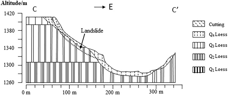
FIGURE 10. C–C′ profile across the stabilization of unstable slope.
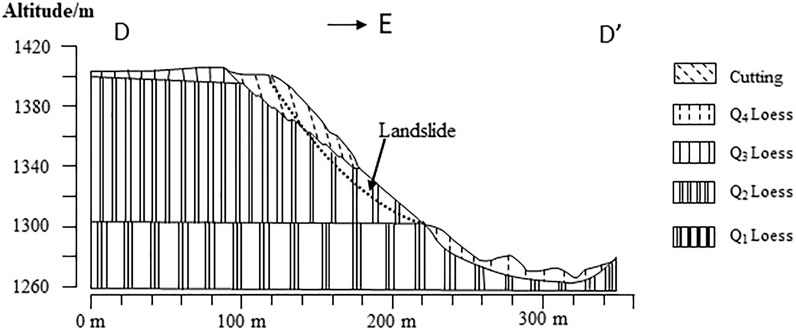
FIGURE 11. D–D′ profile across the stabilization of unstable slope.
Effectiveness and Uncertainty of GSHP Project
Dongzhiyuan loess tableland is the largest topographic platform in Chinese Loess Plateau, with unique hydrological characteristics. In the semi-arid climate, although the total annual rainfall is insufficient, the rainfall is mainly concentrated in the rainy season. Rainfall first accumulates on the huge, flat top surface to form floods, which are then discharged into the surrounding gully system. The major impact of urbanization is the rapid increase in floods because of imperviousness on surface runoff and infiltration due to urban development. On the one hand, the elevated urban floods result in serious gravity and hydraulic erosion to the gully head area, but on the other hand, the scarce rainwater resources are wasted in this process.
GSHP project emphasizes the extreme importance of geological hazard control in reducing the gully head retreat and beneficial utilization of rainwater resources. It arranges the mitigation measures in the following steps: first stormwater regulation, then gully head stabilization, and finally the soil and water conservation on gully slopes and channels.
As shown in Figure 5, the gully heads that invaded into the urban districts with a length of more than 500 m have been backfilled and recreated as Donghu Lake Park. The flood ponds constructed in the Park can store and adjust peak flow before discharging into the Huohanggou Gully. The drainage culvert buried in the backfilled high embankment dissipate the energy of the discharged flood and terminate the process of hydraulic erosion. The stabilization of the unstable slope gets rid of potential gravity erosion in the future. It is believed that GSHP project makes the watershed hydrology of Huohanggou Gully more eco-friendly than before. Direct evidence includes the following facts: The geological disasters that threatened the safety of urban districts in the past 50 years have been eliminated, and more than 90% of soil erosion in this gully has been effectively cut off.
Another advantage of GSHP project is the rainwater harvesting. Flood ponds create waterscape in Donghu Lake Park for leisure and entertainment. The rainwater stored in the rainy season will be transported to support the ecological restoration and improve the soil and water conservation.
As an emerging project, there is still some debate about the basic goals of GSHP project: controlling gully head expansion, eliminating geohazards, reducing soil erosion, or all. In fact, GSHP is a comprehensive project with multiple objectives and large investment. It needs to evaluate the benefits from a long-term perspective through input–output analysis. At least so far, the following technical uncertainties should be noted.
Differential settlement of backfilled loess is an important problem. Settlement cracks in a highly backfilled embankment poses a major threat to the stability of the embankment owing to the potential erosion of groundwater along the cracks, especially in a collapsible loess area. Therefore, strict quality control must be carried out to compact the loess soil as densely as possible during construction period, followed by long-term settlement monitoring. Regular inspection is necessary to check if drainage ditches have been blocked by sediments or by rodents. Emergency backfilling or grouting of the cracks is required if piping is detected.
Disturbed loess becomes more erosive than the natural loess. Rapid surface erosion usually takes place on a loess embankment. Therefore, once the loess embankment is constructed, it is necessary to carry out ecological protection or vegetation restoration of the embankment surfaces by native plants. If a loess slope is partially cut for stabilization of the slope, the freshly exposed surfaces must be covered by vegetation.
The stormwater retention pond, such as that in Donghu Lake Park, is a small reservoir that is located at a gully head that has high potential energy. Close attention must be paid to the defects such as foundation seepage and piping. Also, the risk of secondary disaster must be evaluated based on reservoir engineering principles, such as the extraordinary discharge or even collapse under extreme rainfall conditions, or the liquefaction of foundations during an earthquake.
Conclusion
Summarizing the historical document, this paper analyzes the environmental hazards involved in intensive soil erosion in loess tableland area so as to extract the theoretical concepts concerning the GSHP project. The major conclusions can be drawn as follows.
1) Loess tableland is a specific landform unit with a huge and flat surface, where rainstorms are concentrated to form sudden floods. If flood water is discharged into adjacent gullies without effective control, unpredictable hazards will occur, such as intensive erosion of the gully channel, fast expansion of the gully head, or even landslides.
2) Traditional measurements for soil and water conservation can effectively control sheet erosion on side slopes in a small watershed, but they have less effect on head extension control.
3) Geotechnical stabilization of gully heads or side slopes is required as a priority to control the gully head expansion, so as to establish a base for the subsequent control of sheet erosion.
4) A systematic sewage network needs to be specially designed based on the LID idea, collecting stormwater from the huge surface of the loess tableland, regulating the discharge flow, and transporting the water to places of beneficial usage.
Data Availability Statement
The original contributions presented in the study are included in the article/Supplementary Material, further inquiries can be directed to the corresponding author.
Author Contributions
WL: Data curation, Writing—original draft. HZ: Conceptualization, Methodology, Investigation, Writing—review and editing, Funding acquisition, Project administration. JZ: Investigation. AH: Investigation.
Conflict of Interest
The authors declare that the research was conducted in the absence of any commercial or financial relationships that could be construed as a potential conflict of interest.
Publisher’s Note
All claims expressed in this article are solely those of the authors and do not necessarily represent those of their affiliated organizations or those of the publisher, the editors, and the reviewers. Any product that may be evaluated in this article, or claim that may be made by its manufacturer, is not guaranteed or endorsed by the publisher.
Acknowledgments
All authors are grateful for the financial support provided by the Fundamental Research Funds for the Central Universities of China (No. lzujbky-2017-ct02, lzujbky-2018-it24).
References
Bennett, S. J., Alonso, C. V., Prasad, S. N., and Römkens, M. J. M. (2000). Experiments on Headcut Growth and Migration in Concentrated Flows Typical of upland Areas. Water Resour. Res. 36, 1911–1922. doi:10.1029/2000WR900067
Bennett, S. J. (1999). Effect of Slope on the Growth and Migration of Headcuts in Rills. Geomorphology 30 (3), 273–290. doi:10.1016/S0169-555X(99)00035-5
Chen, S. Y., Xu, J. M., Wang, W. L., Zhao, A. C., and Li, H. Y. (2009). Erosion Features of Head-Cut and its Control Measures on Dongzhiyuan of the Loess Plateau. Bull. Soil Water Conservation 29 (4), 37–41. (In Chinese).
De Baets, S., Poesen, J., Reubens, B., Wemans, K., De Baerdemaeker, J., and Muys, B. (2008). Root Tensile Strength and Root Distribution of Typical Mediterranean Plant Species and Their Contribution to Soil Shear Strength. Plant Soil 305, 207–226. doi:10.1007/s11104-008-9553-0
Derbyshire, E. (2001). Geological Hazards in Loess Terrain, with Particular Reference to the Loess Regions of china. Earth Sci. Rev. 54 (1-3), 231–260. doi:10.1016/s0012-8252(01)00050-2
Dong, Y., Xiong, D., Su, Z., Duan, X., Lu, X., Zhang, S., et al. (2019). The Influences of Mass Failure on the Erosion and Hydraulic Processes of Gully Headcuts Based on an In Situ Scouring experiment in Dry-Hot valley of China. Catena 176, 14–25. doi:10.1016/j.catena.2019.01.004
Guo, M., Wang, W., Kang, H., and Yang, B. (2018). Changes in Soil Properties and Erodibility of Gully Heads Induced by Vegetation Restoration on the Loess Plateau, China. J. Arid Land 10, 712–725. doi:10.1007/s40333-018-0121-z
Huo, A., Peng, J., Cheng, Y., Luo, P., Zhao, Z., and Zheng, C. (2020). Hydrological Analysis of Loess Plateau Highland Control Schemes in Dongzhi Plateau. Front. Earth Sci. 8, 528632. doi:10.3389/feart.2020.528632
Huo, A., Yang, L., Luo, P., Cheng, Y., Peng, J., and Nover, D. (2021). Influence of Landfill and Land Use Scenario on Runoff, Evapotranspiration, and Sediment Yield over the Chinese Loess Plateau. Ecol. Indicators 121, 107208. doi:10.1016/j.ecolind.2020.107208
Li, Y., Shi, W., Aydin, A., Beroya-Eitner, M. A., and Gao, G. (2020). Loess Genesis and Worldwide Distribution. Earth-Science Rev. doi:10.1016/j.earscirev.2019.102947
Shi, N. H. (2001). Study on Historical Geography of the Loess Plateau. Zhengzhou: Yellow River Water Conservancy Press. (In Chinese).
Shi, N. H. (1999). Trifling Notes on Investigation of the Loess Plateau, 3. Collections of Essays on Chinses Historical Geography, p1–28. (In Chinese)., NO.
Shit, P. K., Pourghasemi, H. R., and Bhunia, G. S. (2020). Gully Erosion Studies from India and Surrounding Regions. Springer.
Tsunekawa, A., Liu, G., Yamanaka, N., and Du, S. (2014). Restoration and Development of the Degraded Loess Plateau. China: Springer.
US EPA (2000). Low Impact Development (LID): A Literature Review[R]. United States Environmental Protection Agency. EPA-841-B-00-005.
Vanmaercke, M., Poesen, J., Van Mele, B., Demuzere, M., Bruynseels, A., Golosov, V., et al. (2016). How Fast Do Gully Headcuts Retreat? Earth-Science Rev. 154, 336–355. doi:10.1016/j.earscirev.2016.01.009
Yao, W. B. (2009). The Evolution Process and Causes of Dong Zhiyuan Landform in Historical Period. China: Doctoral thesis of Shaanxi Normal University. (In Chines).
Zhang, Z. H. (1980). Loess in China. GeoJournal 4, 525–540. https://www.jstor.org/stable/41142973.
Zhang, Z. H. (1983). The Compilation Principle of Landscape Type Map of Chinese Loess Plateau. Hydrogeology Eng. Geology. (2), 29–33. (In Chinese).
Keywords: Chinese loess plateau, gully expansion, gully head stabilization, sponge city, soil and water conservation
Citation: Liu W, Zhang H, Zhu J and Hu A (2022) Strategies for Gully Stabilization and Highland Protection in Chinese Loess Plateau. Front. Earth Sci. 10:812609. doi: 10.3389/feart.2022.812609
Received: 10 November 2021; Accepted: 21 February 2022;
Published: 31 March 2022.
Edited by:
Gonghui Wang, Kyoto University, JapanReviewed by:
Jianqi Zhuang, Chang’an University, ChinaShenghua Cui, Chengdu University of Technology, China
Copyright © 2022 Liu, Zhang, Zhu and Hu. This is an open-access article distributed under the terms of the Creative Commons Attribution License (CC BY). The use, distribution or reproduction in other forums is permitted, provided the original author(s) and the copyright owner(s) are credited and that the original publication in this journal is cited, in accordance with accepted academic practice. No use, distribution or reproduction is permitted which does not comply with these terms.
*Correspondence: Huyuan Zhang, emhhbmdodXl1YW5AbHp1LmVkdS5jbg==