 Youjun Li
 Hongri Zhang
 Liming Huang1
- 1Guangxi Transportation Science and Technology Group Co., Ltd., Guangxi, China
- 2School of Naval Architecture, Ocean and Civil Engineering, Shanghai Jiaotong University, Shanghai, China
Landslides are frequent in the Nanpeng River fault zone in southwest Yunnan. Based on a Zhen Qing Expressway survey, the geological conditions and characteristics of landslides in this area were studied. The conclusions are as follows: 1) the geological background was the internal cause of local highly steep slopes and broken rock masses. The main landslide types in study area are fault-type and accumulation landslides. 2) The formation of fault-type landslides is related to endogenous causes, such as tectonic movements, but they are less easily triggered than accumulation landslides. Accumulation landslides are related to broken rock masses and are sensitive to external factors such as rainfall and artificial unloading. 3) The coordinated control of permanent support engineering, local deformation control, and overall support reinforcement should be considered as preventive measures.
Introduction
Fault zones are a common geological structure mainly formed by crustal extrusion or plate relative movement and results in the fragmentation of the rock structure and uneven stress in these areas. Then, frequent landslides (Sun, 2005; Lin and Wang, 2017; Huang et al., 2020; Deng et al., 2021) and structural damage (Liu et al., 2020) are often reported in fault zones. The origin of the geological structure has an important influence on the formation and development of landslides (Martel, 2004). The inter-laminar shear dislocation zones formed by fractures may become potential slide zones, which has been proved by field tests and mesoscopic analysis (Huang et al., 2008). Fractures of river valleys and bank slopes have had barrier and differentiation effects on the transfer of valley slope stress (Huang and Li 2008). The size of landslide distribution in a vertical fault strike was determined to be negatively correlated with the dip angle of the fault, and landslides were more likely to occur when the slope direction is parallel to the fault strike (Chen et al., 2014). Unique original fault structures (like a natural sustaining arch) can strongly inhibit the movement of a landslide before structures are damaged to the volume-expansion point, thus avoiding the occurrence of sudden landslides (Chen et al., 2021). Meanwhile, in highly tectonically active regions, landslides and active faults have been closely related in spatial distribution (Qi et al., 2010; Qi et al., 2021). Some typical landslide movement rates have increased by more than 20% related to the fault activity (Huang et al., 2013; Jiang et al., 2015). Landslide movement rates (LMR) have indicated that more than 70% of global landslides are caused by earthquakes (Broeckx et al., 2020). Therefore, it is necessary to conduct a study on the cause and formation mechanism of landslides in fault zones and then propose appropriate treatment measures.
The faults in southwest Yunnan Province, China, occur at equal intervals and in parallel and cut across geological bodies and geomorphological units with high mountain slopes and deep canyons. Landslides are the main regional geological hazard with a high-frequency in these regions (Huang and Li et al., 2011; Yin et al., 2017). Landslide susceptibility maps prepared by different methods showed that landslides in this area are closely related to fractures, rainfall, and human activities (Lan et al., 2004; Sidle et al., 2011; Shao et al., 2020). As landslides occurred frequently during construction and have caused property damage and geological hazards in Yunnan Province, geological surveys, field experiments, numerical simulations and other methods have been used to study landslides (Sidle et al., 2014; Yang et al., 2015; Du & Chen, 2022) and more results have been obtained in areas with frequent human activities.
However, the Nanpeng River fault zone in southwest Yunnan is subject to few human activities and so inadequate geological and hydrological engineering data are available. The formation mechanisms and classification of landslides in the Nanpeng River fault zone have not been reported. The Zhenkang to Qingshuihe Expressway (hereinafter referred to as Zhen Qing Expressway) follows the Nanpeng River fault zone, which provides research data for landslides in this area. Based on the construction results of Zhen Qing Expressway, this paper examines the geological conditions in the Nanpeng River fault zone, summarizes the local landslide development, characteristics, causes, and history, explores the distribution and formation of landslides, and analyzes the typical landslide design principles and effects to provide reference information for the prevention of landslides.
Project overview
The starting point of Zhen Qing Expressway is located near Zhenkang County, Yunnan Province, and the route is generally oriented from north to south. The end point is at the Dawan River in north Mengding Town (Figure 1). The overview is shown in Table 1.
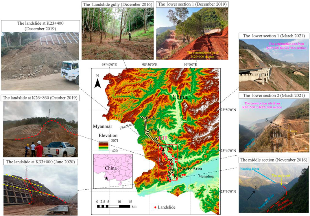
FIGURE 1. Location and typical landslides of the research area.

TABLE 1. Overview of the Zhen Qing Expressway.
The K19 to K33 section of Zhen Qing Expressway is the main research area of this paper and it is spread along the west bank of the Nanpeng River fault zone. During the survey process, geological mapping and site surveys were conducted at a ratio of 1:2000. The researchers participated in the design of landslide treatment for the entire project, identified 50 landslides and hidden danger points, and tracked and verified possible landslides that may occur in the construction process. A total of 10 new landslides and hidden danger points, which were caused by heavy rainfall and artificial disturbances, were added during the construction process.
Analysis of factors influencing landslide development
Topographical features
This research area has a deep canyon due to long-term erosion. The mountain range is mainly north to east; the topography and landform as a whole presents a steep upper, less-steep lower, and deep stepped features. The elevation is 420 m–3,000 m and the relative height difference is 50 m–350 m; the slope topography is mostly concave with a wide upper and narrow lower arc; and the terrain is steep in the middle and flat at the bottom. The sections with different elevations in the research area have greatly different terrain as follows. 1) The upper section (elevation 900 m–3,000 m) has a gradient that varies from 60 to 80 with some parts nearly vertical. 2) The middle section (Elevation 700 m–900 m) exhibits different lithological characteristics, which were mostly formed by accumulation with a main component of from a collapse and the residue. Its gradient varies from 20–45 and has a platform width of 20 m–100 m. 3) The lower section (Elevation 500 m–700 m) with a gradient of approximately 30–60, covered by the Quaternary (Figures 2, 3), and the bottom is the Nanpeng River. The K19 to K33 section of Zhen Qing Expressway is mainly distributed along the lower section.
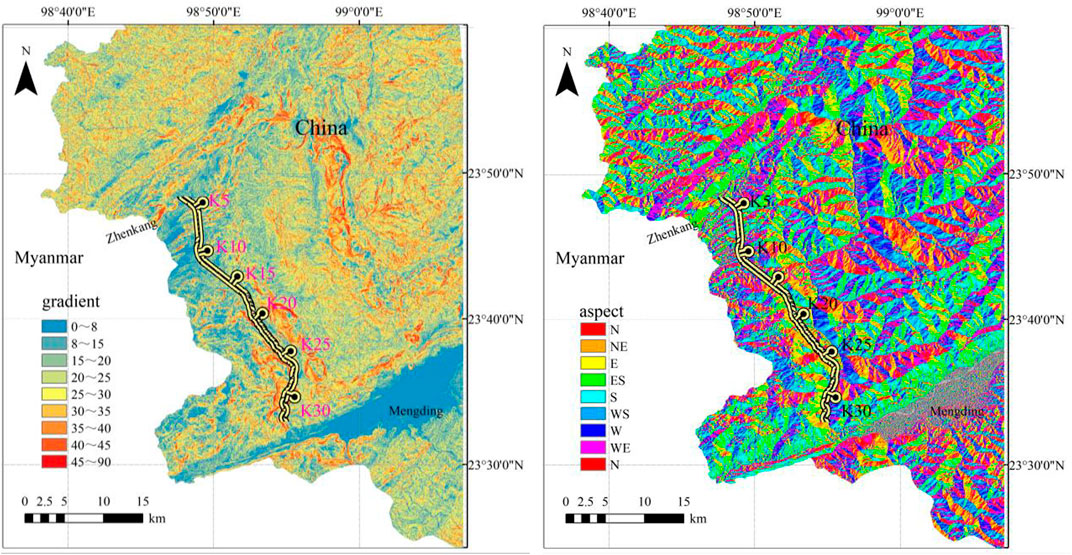
FIGURE 2. Gradient of the research area.
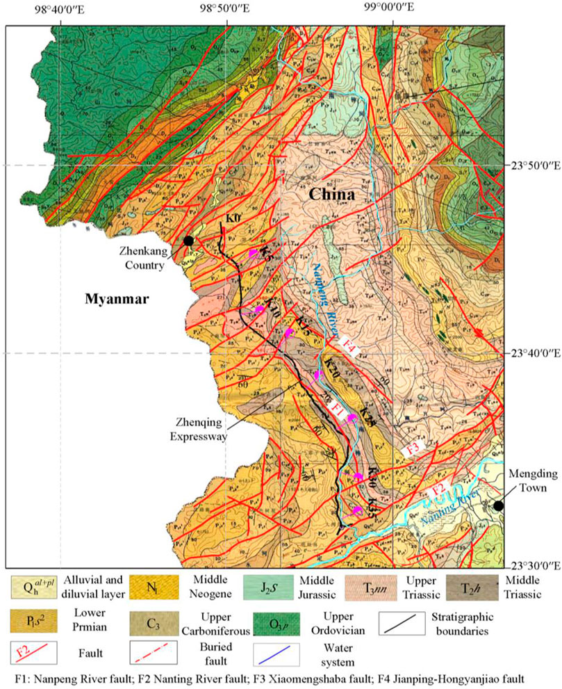
FIGURE 3. Main strata and faults in the research area.
Along the route, the ridgelines are distributed along the both banks of the Nanpeng River, and the strong tectonic movement and erosion-solution effects lead to deep river valleys and the confrontation of peaks on both sides. Topographic and geomorphological factors, such as elevation, gradient, and undulation, exhibit the following characteristics. 1) The elevations of the bottom of the Nanpeng River, the collapsed slope platform on the west bank, and the west side are 200 m–400 m, 498 m–3,000 m, and 1,000 m–1,500 m, respectively. This huge height difference constitutes a natural air front. 2) The gradient change trend is steep-slow-steep and forms a typical stepped landform. The steeper slope controls the direction of gravity and tectonic stress on the slope and increases the possibility and danger of landslides. 3) The gradient of the upper section is greater than 45, which provides a material source to the middle section.
Stratigraphic lithology and geological formations
The research area is located at the boundary between the Myanmar and Philippine plates. The fold belts named Fugong-Zhenkang and Changning-Menglian intersect in this area. The principal stress direction is NNE-SEE (Xie et al., 2001), and the research area is subjected to compressive stress from the east and west sides. The geological strata of the Quaternary, the Upper Triassic, and the Lower Permian is exposed in the research area and excludes the Cretaceous and Jurassic. The area is dominated by a large area of sedimentary strata. Clastic and carbonate rocks are the main components. The loose clastic and carbonate rock groups with soft and weak phases are distributed in strips along the fault zone (Figure 3). The main attitude of the rock mass of the K19 to K30 section varies from SW215° < 30° to SW240° < 60°. In the area near the Nanting River fault, a M7.6 earthquake occurred in 1988 (Zhu et al., 1994; Wang et al., 2015) and the attitude of the rock mass changed from NE50° < 20° to SW200° < 30°. Carbonate faulting and clastic rock twisting are found in the area. Therefore, the rock mass structure in the research area is relatively broken, which indicates that the landslide has a rich source of material.
Meteorology and hydrology
The research area is in the low-latitude area of southwestern Yunnan, with an average annual rainfall of 1300 m–1,500 mm, and the rainy season is concentrated in May to October. The area lies in the subtropical monsoon climate zone. Continuous rainfall in the rainy season often exceeds 15 days. The rainfall in this area exhibits characteristics of high intensity, long time, and short interval. The types of groundwater in the research area are mainly loose rock pore water, bedrock fissure water and carbonate rock karst fissure water. All of them are recharged by rainfall and have the characteristics of seasonal variation. As shown in Figure 3, the watersheds on both sides are composed of carbonate rocks, so the pore water and bedrock fissure water are in the recharge area and runoff area of karst fissure water, and receive recharge from karst fissure water. This means karst fissure water recharges them directly.
Types of landslides and formation mechanisms of the Nanpeng River fault zone
Types of landslides in the Nanpeng River fault zone
The above analysis indicates that the research area has a typical stepped landform and large undulating terrain, which provides space for landslides. The hard carbonate rock composition controls the maximum boundary of slope deformation and failure so that the soft clastic rock in the area easily forms secondary structural planes after the action of the structure and earthquake, which becomes the priority failure deformation portion. The softer clastic rock in the middle section is in the runoff and drainage area of carbonate fissure water. The rock mass structure of clastic rock in this area is broken, and provides abundant groundwater migration and recharge channels (Liu et al., 2022a) and favorable conditions for the development of the rainfall slip effect (Liu et al., 2022b). Earthquakes frequently occur in southwestern Yunnan. The minimum straight-line distance between the research area and the Nanting River fault is only 5 km, which indicates an obvious seismic distance effect. Earthquakes can damage the mechanical properties of the rock mass and provide internal power for the formation of landslides. Finally, human activities, such as road cutting, are likely to cause stress redistribution of the slope and break the original stable state. Therefore, the geological background of this area is the internal cause of landslide formation and rainfall and artificial activity are external causes. According to the above factors, the landslide type in the research area can be divided into fault-affected landslides and accumulation landslides.
Mechanism of landslide formation in the Nanpeng River fault zone
According to the results of the regional investigation and engineering exploration, the formation mechanism of landslides in the Nanpeng River fault zone occurs as follows. 1) During the formation of folds and faults, the two groups of large faults in the NW and NE directions strongly squeeze the rock mass and act on the four-dimensional stress field pattern. The harder rock layers in the Daxiaodong anticline are uplifted to form an unloading effect and the softer rock layers are extruded into strips to form a wide platform. 2) During the process of mountain denudation, weathering, and river erosion, the rock mass in the core of the anticline is gradually cut down, the bottom support is gradually reduced, the front surface of the rock mass is increased, and the unloading effect is further intensified. In the process of weathering and denudation, a large amount of colluvial gravel and gravel soil are formed in the carbonate rock formation, which are accumulated on the platform of the softer rock formation. 3) Events, such as strong earthquakes and rainstorms, cause loose blocks to become unstable and push to form landslides and further push the front edge of the collapsed slope to deform. 4) Under the action of erosion, part of the material of the steeper landslide body accumulates on the slope, and along with the lithological different zone in the long-term high-intensity rainfall season, a saturated zone is formed, which results in a lateral net water pressure and pushes the upper part of the landslide body again. Thus, the existing landslide gradually forms (Figure 4). The formation of fault-affected landslides undergoes the above processes, whereas that of accumulation landslides mainly undergoes different processes.
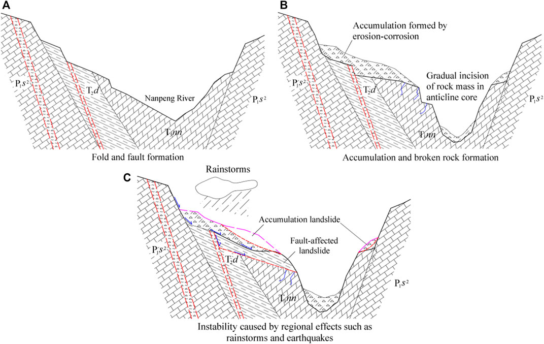
FIGURE 4. Front and landslide depression of the K33 + 800 fault-influenced landslide.
Countermeasures for slope protection design in the Nanpeng River fault zone
Characteristics of fault-influenced landslides and countermeasure design
The formation of fault-influenced landslides in the research area is mainly affected by the geological background and earthquakes. Such landslides have the following characteristics in topography, distribution range, plane shape, and rock structure. 1) The topography has a typical steep-gentle-steep step-like topography. 2) The distribution area of the landslide is near the influence range of the Holocene active fault, which is called the Nanting River fault, and the distance effect on landslide is obvious. 3) The plane of landslide is mostly tower shaped, and the sliding surface is in the weak structural plane of the rock mass. 4) The lithology of the stratum is mainly composed of clastic and carbonate rocks, and the carbonate weathering layer of landslides is more than 50 m thick. As the main boundary of this type of landslide, carbonate rock controls the deformation range of the landslide and recharges the groundwater in the clastic rock. The harder carbonate rock boundary facilitates the amplification of seismic effects, and so landslides with huge volumes are mostly distributed nearby or above the Holocene active fault influence range.
Considering the K33+800 landslide as an example (Figure 5), the landslide is located on a slope approximately 4.5 km from the Nanting River fault. The overall terrain slope is 25–35°. The steep-platform-gentle typical chair landform had the following shape: the width of the gentle slope platform was approximately 100 m, the main sliding direction of the landslide was approximately 94°, the trailing edge is a chair-shaped steep sill with a height difference of approximately 100 m, and landslide depressions develop under the steep sill. On both sides of the depression branch, the depression is a double-ditch homologous landform, the front edge is convex like a tongue, and the sliding body is approximately 1.8 km long and 1.2 km wide. The landslide volume is estimated at more than 18 million m3. The east side of the mountain limits the possibility of large deformation of the landslide. The long-term erosion and unloading of the Nanpeng River could not revive the landslide. Therefore, the occurrence of the landslide is mainly affected by the earthquake and the sensitivity to external factors is low. The Zhen Qing Expressway raises the longitudinal plane in this section to avoid cutting the toe of the slope and tries to pass as a bridge to minimize disturbance to the landslide. No signs of deformation have been observed to date (after the completion of this section of the bridge).
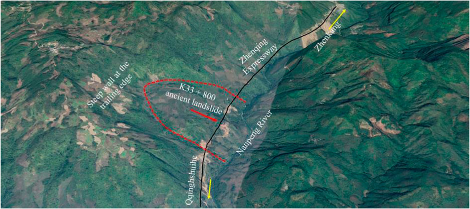
FIGURE 5. K33 + 800 fault-affected ancient landslide (from Google Earth).
Characteristics of accumulation landslides and protection countermeasures
Accumulation landslides have the following characteristics and triggering factors in the distribution range. These landslides are mainly distributed in the middle section of the stepped landform, which is mainly covered by residual and slope deposits of poor sorting and high porosity. The underground water type is loose rock pore water and is recharged by rain. For common accumulation landslides, rainfall and engineering construction have a great influence on the stability of the landslides in the study area. The failure modes of accumulation landslides are mainly of the traction type, and the sliding surface is an arc or broken line type. The sliding surface is shallow and often located at the rock-soil interface, and the landslide volume is generally small.
The landslide from cutting accumulation on the right side of K26 + 860 is considered as an example. The slope was originally designed to be 40 m high (10 m-high a grade) and limited by the 220 kV electrical tower at the rear; the comprehensive slope rate was designed as 0.75 and the whole slope was equipped with anchor cable lattice beams. The grade 3# and 4# had completed the excavation and anchor cable tensioning before the landslide occurred. Cumulative rainfall in the landslide area reached 203 mm in 24 h on 7 October 2019, and the landslide occurred 2 days later. The slope dropped rapidly in a projectile shape and accumulated at a comprehensive slope degree of 9. The structure of the non-sliding soil on the trailing edge of the landslide was extremely loose and the section was rough. The sliding surface of 15 m deep is located inside the accumulation body with an arc shape. The shear entrance is approximately 10 m behind the excavation line, and the shear exit is at the foot of grade 2# (Figures 6, 7). An overly loose soil structure may be the cause of landslides still occurring after protective structures are completed, and researchers have built a corresponding slope FEM under saturated conditions by the GEO5 to verify. A comprehensive method combining test evaluation, empirical assessment, and back calculation evaluation is used to evaluate the physical and mechanical parameters of the rock and soil. For the underlying bedrock, its parameters have little effect on the results of slope simulation analysis, which can be directly evaluated based on field investigation data. For residual soil and the sliding zone, the key parameters, such as modulus and strength, are calculated by a back analysis method according to the parameter interval provided by a laboratory test. According to the consistency requirements of slope failure characteristics and the stability coefficient in each excavation stage of landslide simulation analysis and actual working conditions, the rock and soil adopts to the Mohr-Coulomb model and the parameters under saturated conditions as shown in Table 2.
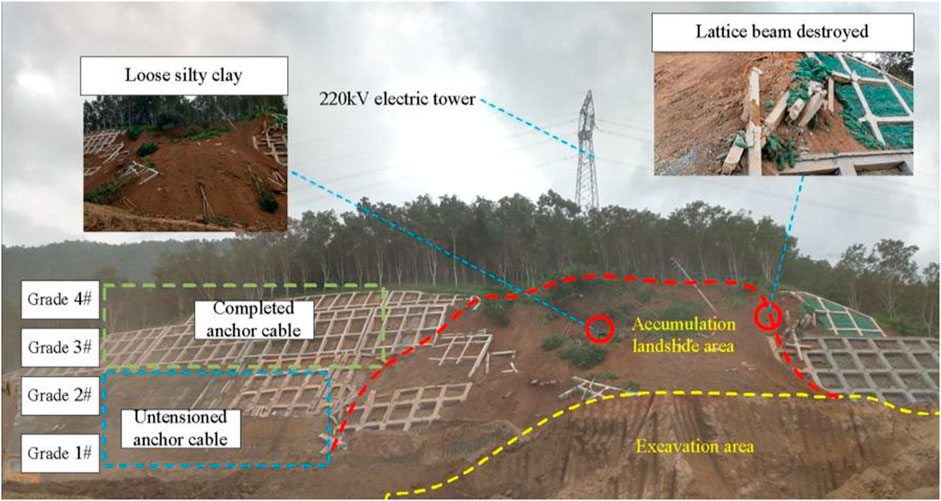
FIGURE 6. Accumulation landslide at K26 + 860 (7 October 2019).
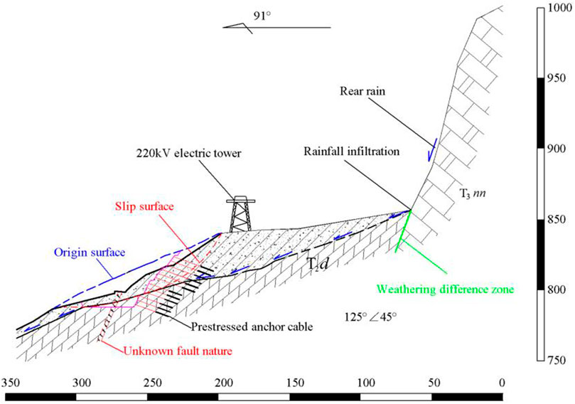
FIGURE 7. Engineering geologic profile of K26 + 860.
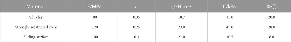
TABLE 2. Physical and mechanical parameters.
The origin slope design adopted the lattice beam anchor cable with a horizontal and vertical spacing of 3 m, a length of 20 m–40 m, and a single anchor cable design pullout force of 550 kN. The calculation results show that after completion of grade 4#, the approximately connected plastic zone distributed from the bottom to the top appeared. After completion of grade 2#, the plastic zone appears and rapidly penetrates the whole slope (Figure 8). Therefore, the main reasons for the landslide are as follows. 1) The soil has a high porosity, low shear strength, and developed seepage channels. Rainfall easily infiltrates along the surface and accumulates at the rock-soil interface, forming a potentially weak surface. 2) Through the unloading excavation at the front edge of the slope, even if the unloading height is as small as 5 m, the plastic zone is easily formed.
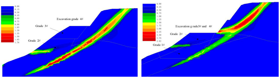
FIGURE 8. Plastic shear strain zone during the excavation of K26 + 860 slope.
The basic countermeasures to deal with the landslide of the accumulation body are as follows. 1) In the design of the landslide of the accumulation body at the fault, when rainstorm conditions are considered, the influence of the average rainfall intensity and duration on the slope stability in the past 3 years should be combined with the meteorological and hydrological conditions of the region for the temporary safety of construction. 2) Unloading at the bottom of the loose accumulation easily causes deformation cracks in the rear, and the slopes at all levels should be cut off based on the feasibility. According to the above treatment countermeasures, the K26 + 860 landslide is treated by clearing unloading, slope top micro piles, and using deep anchoring. A cut landslide generally remains stable for at least 2 years after completion (Figure 9).
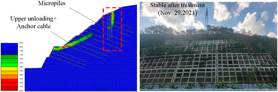
FIGURE 9. Elevation of the K26 + 860 landslide after disposal.
Conclusions
1) The tectonic background of the Nanpeng River fault zone is the internal cause of landslide formation, and the stress pattern of extrusion on all sides is the main factor that constitutes high and steep slopes and broken rock bodies, which provides space for landslides; frequent seismic activities provide energy sources for landslides.
2) The formation process of the landslide in the Nanpeng River fault zone is mainly as follows: the fault strongly squeezes the rock mass to form steep terrain and an initial structural plane → under the action of erosion and dissolution, the mountain mass cuts into a loose deposit → and the mountain mass becomes unstable due to strong earthquakes, rainstorms, and artificial activities. Then, blocks become unstable and move to form landslides. These types of landslides are mainly fault-affected and accumulation landslides.
3) The fault-affected landslides in the Nanpeng River fault zone have good stability and their gentle slope platforms can be used as construction sites; accumulation landslides are more sensitive to rainfall and artificial activities. Unfavorable working conditions should be fully predicted and dynamic adjustments should be implemented to coordinate permanent support. Coordination of engineering measures and local deformation control measures should be used as preventive measures (AQSIQ, 2015).
Data availability statement
The datasets presented in this study can be found in online repositories. The names of the repository/repositories and accession number(s) can be found in the article/Supplementary Material.
Author contributions
HZ: writing and revising the manuscript and presiding over relevant research. YL: data editing and sorting of the manuscript and manuscript writing.
Conflict of interest
YL, HZ, LH, HL, and XW were employed by Guangxi Transportation Science and Technology Group Co., Ltd.
Publisher’s Note
All claims expressed in this article are solely those of the authors and do not necessarily represent those of their affiliated organizations, or those of the publisher, the editors, and the reviewers. Any product that may be evaluated in this article, or claim that may be made by its manufacturer, is not guaranteed or endorsed by the publisher.
References
Aqsiq, (2015). General administration of quality supervision, inspection, and quarantine of the people’s republic of China. Seismic Ground Motion Param. Zonation Map China, GB18306. 30 .
Broeckx, J., Rossi, M., Lijnen, K., Campforts, B., Poesen, J., and Vanmaercke, M. (2020). Landslide mobilization rates: A global analysis and model. Earth-Science Rev. 201, 102972. doi:10.1016/j.earscirev.2019.102972
Chen, H., Qin, S. Q., Xue, L. L., and Xu, C. (2021). Why the Xintan landslide was not triggered by the heaviest historical rainfall: Mechanism and review. Eng. Geol. 294, 106379. doi:10.1016/j.enggeo.2021.106379
Chen, X. L., Hui, H. J., and Zhao, Y. H. (2014). The relationship between fault properties and landslide distribution: Taking the large-scale landslide in the Wenchuan earthquake as an example. Seismol. Geol. 36 (2), 358–367.
Deng, J. H., Gao, Y. J., Yao, X., Dai, F. C., Ren, K. Y., Wang, F., et al. (2021). Recognition and implication of Basu giant rock avalanche. Adv. Eng. Sci. 53 (03), 19–28.
Du, Y., and Chen, C. (2022). Data mining for landslide genetic mechanism analysis in the yunnan Province of China. Geotech. Geol. Eng. (Dordr). 40 (11), 5631–5642. doi:10.1007/s10706-022-02237-z
Huang, R. Q., and Li, W. (2011). Formation, distribution and risk control of landslides in China. J. Rock Mech. Geotechnical Eng. 3 (2), 97–116. doi:10.3724/sp.j.1235.2011.00097
Huang, R. Q., and Li, W. L. (2008). Research on development and distribution rules of geohazards induced by Wenchuan earthquake on 12th may, Yanshilixue Yu Gongcheng Xuebao/Chinese Journal of Rock Mechanics and Engineering, 27(12), 2585–2592.
Huang, R. Q., Pei, X., and Cui, S. A. (2016). Study on the fragmentation characteristics and formation mechanism of rock mass in the sliding zone of Daguangbao landslide. J. Rock Mech. Eng. 35 (1), 1–15.
Huang, R. Q., Pei, X. J., and Li, T. B. (2008). Basic characteristics and formation mechanism of the largest scale landslide at Daguangbao occurred during the Wenchuan earthquake. J. Eng. Geol. 16 (6), 730–741.
Huang, X., Yang, W. M., Zhang, C. S., Shen, J. F., and Liu, T., (2013). The genetic mechanism of the Suoertou landslide in the Pingding-Huama fault zone in southern Gansu. Geol. Bull. 32 (12), 1936–1942.
Jiang, X. Z., Wen, B. P., and Jiang, S. (2015). Analysis of the main controlling factors of the luoertou landslide activity in zhouqu, Gansu_Jiang xiuzi. J. Jilin Univ. (Earth Sci. Ed. 45 (6), 1798–1807.
Lan, H. X., Zhou, C. H., Wang, L. J., Zhang, H. Y., and Li, R. H. (2004). Landslide hazard spatial analysis and prediction using GIS in the Xiaojiang watershed, Yunnan, China. Eng. Geol. 76 (1-2), 109–128. doi:10.1016/j.enggeo.2004.06.009
Lin, Q. G., and Wang, Y. (2018). Spatial and temporal analysis of a fatal landslide inventory in China from 1950 to 2016. Landslides 15 (12), 2357–2372. doi:10.1007/s10346-018-1037-6
Liu, N. F., Li, N., Li, G. F., Song, Z. P., and Wang, S. G. (2022a). Method for evaluating the equivalent thermal conductivity of a freezing rock mass containing systematic fractures. Rock Mech. Rock Eng. 55, 7333–7355. doi:10.1007/s00603-022-03038-9
Liu, N. F., Li, N., Wang, S. G., Li, G. F., and Song, Z. P. (2022b). A fully coupled thermo-hydro-mechanical model for fractured rock masses in cold regions. Cold Regions Sci. Technol. 205, 103707. doi:10.1016/j.coldregions.2022.103707
Liu, N. F., Li, N., Xu, C. B., Li, G. F., Song, Z. P., and Yang, M. (2020). Mechanism of secondary lining cracking and its simulation for the Dugongling tunnel. Rock Mech. Rock Eng. 53 (10), 4539–4558. doi:10.1007/s00603-020-02183-3
Martel, S. J. (2004). Mechanics of landslide initiation as a shear fracture phenomenon. Mar. Geol. 203 (3-4), 319–339. doi:10.1016/s0025-3227(03)00313-x
Qi, S., Xu, Q., Lan, H., Zhang, B., and Liu, J. (2010). Spatial distribution analysis of landslides triggered by 2008.5. 12 Wenchuan Earthquake, China. Eng. Geol. 116 (1-2), 95–108. doi:10.1016/j.enggeo.2010.07.011
Qi, T., Meng, X., Qing, F., Zhao, Y., Shi, W., Chen, G., et al. (2021). Distribution and characteristics of large landslides in a fault zone: A case study of the NE qinghai-tibet plateau. Geomorphology 379, 107592. doi:10.1016/j.geomorph.2021.107592
Shao, X., Ma, S., Xu, C., Shen, L., and Lu, Y. (2020). Inventory, distribution, and geometric characteristics of landslides in baoshan city, yunnan Province, China. Sustainability 12 (6), 2433. doi:10.3390/su12062433
Sidle, R. C., Furuichi, T., and Kono, Y. (2011). Unprecedented rates of landslide and surface erosion along a newly constructed road in Yunnan, China. Nat. Hazards (Dordr). 57 (2), 313–326. doi:10.1007/s11069-010-9614-6
Sidle, R. C., Ghestem, M., and Stokes, A. (2014). Epic landslide erosion from mountain roads in yunnan, China – challenges for sustainable development. Nat. Hazards Earth Syst. Sci. 14, 3093–3104. doi:10.5194/nhess-14-3093-2014
Sun, D. Y. (2005). Landslide at badu station on nankun railway and its treatment. J. Railw. Eng. Soc. S1, 320–326.
Wang, S. J., Liu, B. J., Zhang, J. S., Liu, B. F., Duan, Y. L., Song, X. H., et al. (2015). Study on the velocity structure of the crust in southwest Yunnan of the north-south seismic belt—results from the menghai-gengma-lushui deep seismic sounding profile. Sci. China Earth Sci. 58 (12), 2175–2187. doi:10.1007/s11430-015-5189-0
Xie, F. R., Su, G., Cui, X. F., Shu, S. B., and Zhao, J. T. (2001). Modern tectonic stress field in Southwest Yunnan, China. Acta seimol. Sin. 14 (1), 18–24. doi:10.1007/s11589-001-0157-5
Yang, Y. Y., Xu, Y. S., Shen, S. L., Yuan, Y., and Yin, Z. Y. (2015). Mining-induced geo-hazards with environmental protection measures in yunnan, China: An overview. Bull. Eng. Geol. Environ. 74 (1), 141–150. doi:10.1007/s10064-014-0608-6
Yin, Y., Xing, A., Wang, G., Feng, Z., Li, B., and Jiang, Y. (2017). Experimental and numerical investigations of a catastrophic long-runout landslide in Zhenxiong, Yunnan, southwestern China. Landslides 14 (2), 649–659. doi:10.1007/s10346-016-0729-z
Keywords: landslide formation mechanism, disaster prevention, landslide, fault zone, accumulation landslide
Citation: Li Y, Zhang H, Huang L, Li H and Wu X (2023) The formation mechanism of landslides in typical fault zones and protective countermeasures: A case study of the Nanpeng River fault zone. Front. Earth Sci. 10:1092662. doi: 10.3389/feart.2022.1092662
Received: 08 November 2022; Accepted: 28 November 2022;
Published: 05 January 2023.
Edited by:
Naifei Liu, Xi’an University of Architecture and Technology, ChinaCopyright © 2023 Li, Zhang, Huang, Li and Wu. This is an open-access article distributed under the terms of the Creative Commons Attribution License (CC BY). The use, distribution or reproduction in other forums is permitted, provided the original author(s) and the copyright owner(s) are credited and that the original publication in this journal is cited, in accordance with accepted academic practice. No use, distribution or reproduction is permitted which does not comply with these terms.
*Correspondence: Hongri Zhang, MjUzNTQxNDYxQHFxLmNvbQ==