 Fan Zili
 Fu Guang1
 Fu Hongjun
95% of researchers rate our articles as excellent or good
Learn more about the work of our research integrity team to safeguard the quality of each article we publish.
Find out more
ORIGINAL RESEARCH article
Front. Earth Sci. , 10 January 2023
Sec. Structural Geology and Tectonics
Volume 10 - 2022 | https://doi.org/10.3389/feart.2022.1052611
This article is part of the Research Topic Basins and Related Tectonics View all 11 articles
From accumulation mechanisms and the identification of effective faults, hydrocarbon distribution in slope areas of petroliferous basins is assessed. In this study, we superimpose two methods to develop a set of key methods, which can identify effective faults for hydrocarbon accumulation in slope areas. The first of this set of methods includes locating the distribution area of the connected sand bodies and paleotectonic ridges overlying the formation where the sand bodies are located, which aids determining the lateral migration path of hydrocarbons in slope areas. The second set of methods includes identifying the lateral sealing parts of faults that are oriented perpendicular or oblique to the channel sand bodies, thereby determining the faults that are effective for hydrocarbon accumulation. By applying these methods, we identify the effective faults in the first member of the Nantun Formation (K1n1) on the Wunan slope of the Wuerxun Depression in the Hailar Basin. The results show that the effective faults in K1n1 are located mainly in its middle and northern parts, with a few distributed in the south-central part. This is conducive to reservoir development, since hydrocarbons which were generated in the western trough source rocks of K1n1, accumulated in the nearby trap formed from a suitable configuration of the fault and sand body of K1n1. This is consistent with previous exploration data, and the observation that hydrocarbons discovered in K1n1 on the Wunan slope are mainly distributed in the middle and northern parts of the region, and a small amount occur in the south-central part. The results show that this set of methods is feasible for determining effective faults for hydrocarbon accumulation in slope areas.
Research on hydrocarbon exploration in the slope areas of petroliferous basins has expanded considerably in recent years. The results suggest that in slope areas, the distribution of hydrocarbons is influenced by its lateral migration path and controlled by whether or not faults are sealed, the relationship between these faults and the spread of the river channel sand bodies, as well as the relationship between the faults and the lateral migration path of the hydrocarbons. Sealed faults along hydrocarbon migration pathways that are oriented perpendicular or oblique to the channel sand bodies are effective in reservoir formation; other faults are not considered as effective for hydrocarbon accumulation.
Recently, multiple studies have attempted the identification of effective faults for hydrocarbon accumulation in slope areas; these studies adopted a similar methodology. For example, Jin (2012), Henares et al. (2014), Zhu et al. (2015), Li et al. (2017), Meng et al. (2020a) and Yang et al. (2020b), made predictions of the argillaceous content of fault rocks by assessing fault distance in the target formation, as well as the thickness of the faulted rock formation and their argillaceous content. Studies also assessed the lateral sealing of faults according to the predicted relative value of the argillaceous content of the fault rocks (Lyu et al., 2016; Fu et al., 2012; Fu and Zhan, 2016; Wang et al., 2017). Other studies focused on two aspects—the distribution of the sand body connection area and oil–gas potential field at the top of the formation, which were then combined to predict the lateral migration path of hydrocarbons in the slope area (Zhou et al., 2006; Wang et al., 2009; Fu and Wang, 2018a; Wang et al., 2018b; Fu and Wang, 2019); the relationship between the lateral migration path of the hydrocarbons and the distribution of faults were used to identify the effective faults for hydrocarbon accumulation. A common observation from these studies is that faults located only along the lateral migration path of hydrocarbons are effective for hydrocarbon accumulation. This has contributed to an improved understanding of the regularity of hydrocarbon distributions in slope areas of petroliferous basins and improved hydrocarbon exploration practices.
However, the distribution of hydrocarbons in slope areas is affected not only by fault sealing and lateral migration path distribution, but also by their spatial configuration, in addition to the spatial configuration of the fault orientations and the orientation of the channel sand bodies. Relatively few field-based studies of effective faults for hydrocarbon accumulation in slope areas combine these influences in their assessments. Most studies are limited to the spatial configuration between sealed faults and the lateral migration path of hydrocarbons (Fu et al., 2014; Wu et al., 2015; Hu et al., 2018) and do not consider the configuration between sealed faults and the orientation of channel sand bodies. Thus, these results do not accurately reflect the hydrocarbon distribution in slope areas; this makes hydrocarbon exploration practices uncertain and risky. Effective fault determination methods for hydrocarbon accumulation in slope areas is important for correct understanding of the hydrocarbon distribution in slope areas and for guiding the exploration.
Exploration studies show how hydrocarbon generated from source rocks in sag areas move along a lateral migration path in a sand body to slope areas under the effect of buoyancy. Hydrocarbons accumulate in traps formed by a suitable configuration of the lateral migration path of hydrocarbons with the fault and sand body; no hydrocarbons accumulate if the configuration of the trap consists of just the fault and sand body. Most fault and sand body traps form as a result of the perpendicular or oblique intersection of sealed faults and channel sand bodies. Therefore, only sealed faults that are perpendicular or oblique to the channel sand bodies and located in the lateral migration path of the hydrocarbons could stop their lateral migration. This would allow the hydrocarbons to accumulate in traps formed by suitable configurations of the fault and sand body (Figure 1A). If sealed faults, perpendicular or oblique to the channel sand bodies, are not located along the lateral migration path of the hydrocarbons, they would not accumulate in the fault—sand body configuration (Figure 1B). This analysis demonstrates that only sealed faults located in the lateral migration path of hydrocarbons, and oriented perpendicular or oblique to channel sand bodies, are effective faults for hydrocarbon accumulation in slope areas. If any these three conditions are not met, the fault is not considered effective for hydrocarbon accumulation in slope areas.
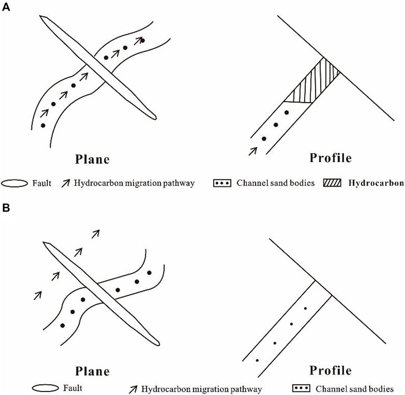
FIGURE 1. Schematic of typical faults for hydrocarbon accumulation in a slope area; (A) Effective faults for hydrocarbon accumulation; (B) Non-effective faults for hydrocarbon accumulation.
To determine the effective faults for hydrocarbon accumulation in slope areas, the lateral migration path of hydrocarbons in the slope areas and the distribution of the sealed faults are identified. Configuring them could help determine the effective faults for hydrocarbon accumulation.
To determine the lateral migration path of hydrocarbons in slope areas, the areal distribution of the connected sand body in the target layer and the distribution of paleotectonic ridges overlying the sand body are confirmed first. When superimposed, they demarcate the lateral migration path of hydrocarbons in the slope area. A distribution map of sand ratio of the formation in the target formation is made from drilling data—specifically, the sand ratio of the formation at known wells and the characteristics of the hydrocarbon in the sand body. From this, the minimum sand ratio of the formation in which the sand bodies are located in the hydrocarbon distribution area is taken as the minimum sand ratio of the formation required for sand body connection (Zhang et al., 2018). Encircling the area where the sand ratio of the formation is larger than the minimum sand ratio of the formation required for sand body connection, gives us the sand body connection area (Figure 2). The paleo-burial depth of the formation top where the sand body occurs is reconstructed by the paleo-burial depth reconstruction method (Fu et al., 2021) to estimate the paleo-burial depth during hydrocarbon accumulation. The hydrocarbon paleo-potential energy is calculated from Eq. 1 to create a paleo-potential energy distribution map (Figure 2). The distribution of paleotectonic ridges overlying the formation where the sand body is located can be obtained by the hydrocarbon paleo-potential energy isoline method (Figure 2). The lateral migration path of hydrocarbons in the slope area is obtained by superimposing the above-mentioned sand body connection area with the distribution of paleotectonic ridges overlying the formation where the sand body is located (Figure 2).
where:
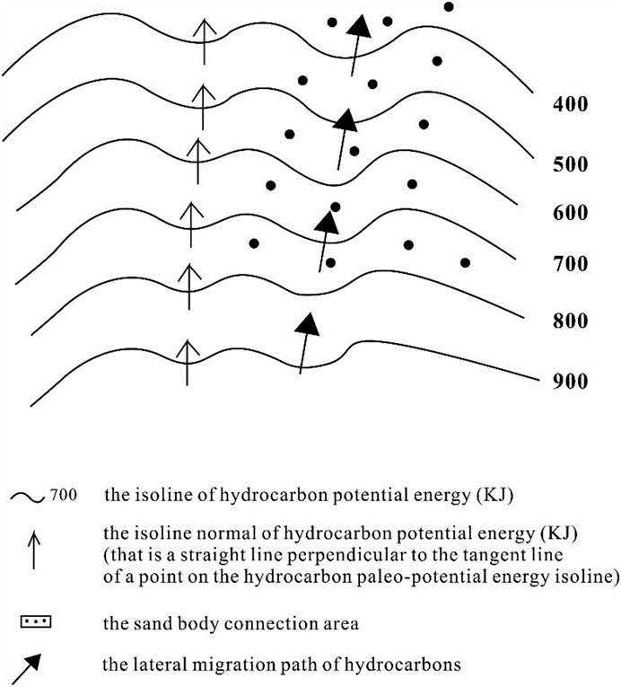
FIGURE 2. Schematic determining the lateral migration path of hydrocarbons in a slope area.
To determine the distribution of sealed effective faults, it is necessary to determine the distribution of the sections of the faults that are laterally sealed and the distribution of faults that are oriented perpendicular or oblique to the channel sand bodies. For this, the distribution of faults developed in the target formation of the slope area is interpreted from 3D seismic data, the fault distance in the target formation, and the thickness and argillaceous content of the rock formation being faulted. The argillaceous content of faults at different sites is calculated from Eq. 2; thus, the argillaceous content of the fault rocks at all known wells in the study area is estimated, as well as the displaying features of the hydrocarbon in nearby target formations. The minimum argillaceous content of fault rocks in the hydrocarbon distribution area is taken as the minimum argillaceous content of fault rocks required for hydrocarbon accumulation through faults (Fu and Hu, 2016). Sealed fault sites typically have greater fault rock argillaceous content than the minimum argillaceous content of fault rocks required to trap hydrocarbons.
Where
Research on sedimentary microfacies in the study area help determine the direction of the spread of channel sand bodies. The orientation of fault extensions developed within the target formation are acquired by interpreting the above-mentioned 3D seismic data. The distribution of faults that are perpendicular or oblique to the channel sand bodies are obtained by combining the direction of the spread of channel sand bodies with the orientation of fault extensions. When the distribution of the sealed part of the faults are superimposed over faults that are perpendicular or oblique with the channel sand bodies, the parts that overlap mark the distribution area of the effective faults that seal-in the hydrocarbons (Figure 1). Superimposing the distribution of the lateral migration path of the hydrocarbons in the slope area and the distribution of effective faults which seal them in, the sealed faults that are located both on the lateral migration path of the hydrocarbons, and are perpendicular or oblique to the channel sand bodies are the effective faults for the accumulation of hydrocarbons (Figure 1).
The methods discussed in this paper were applied to the first member of the Nantun Formation (K1n1) on the Wunan slope of the Wuerxun Depression in the Hailar Basin. We examined the potential of this method in determining the effective faults for hydrocarbon accumulation in the Wunan slope area by correlating the results from this sample study with the currently known distribution of hydrocarbons in the area.
The Wunan slope area is located to the east of the troughs in the southern part of the Wuerxun Depression. It includes three tectonic units—ring depressions, slope breaks, and slope areas (Figure 3). Currently, the Wuerxun Depression is the focus area for hydrocarbon exploration. The stratigraphy of this area includes, from bottom to top, the Lower Cretaceous Tongbomiao Formation, the Nantun Formation, the Damoguaihe Formation and the Yimin Formation, the Upper Cretaceous Qingyuangang Formation, with thin Cenozoic strata (Figure 3). A large volume of the hydrocarbons occur in K1n1; they originate from the lower source rocks in K1n1 of the western trough. In planar view, the hydrocarbons are mainly distributed near the faults in the slope area of the ring depressions and slope breaks, but not all faults in the slope area host hydrocarbons. This is mainly controlled by the distribution of the effective faults for the hydrocarbon accumulation. To guide the hydrocarbon exploration in K1n1 in the Wunan slope area requires accurate identification of the effective faults for hydrocarbon accumulation.
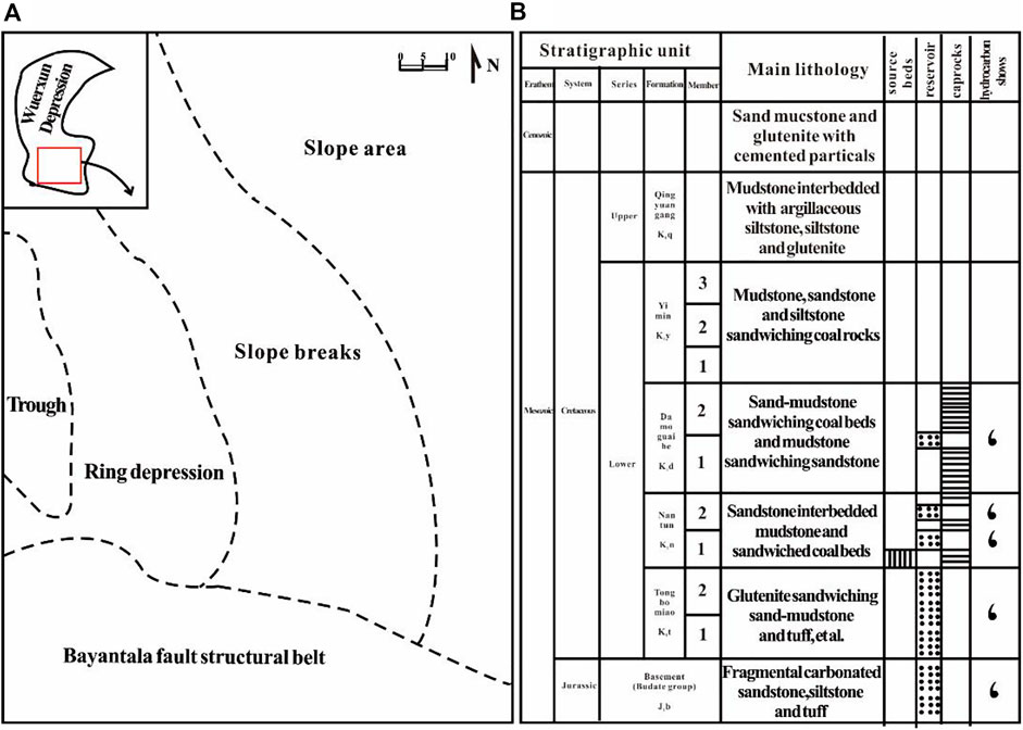
FIGURE 3. (A) Structural and (B) stratigraphic characteristics of the Wunan slope area.
The typical structure of hydrocarbon reservoirs corresponds well with the accumulation model for hydrocarbons trapped in K1n1 along the Wunan slope. Here, the hydrocarbons generated from the source rocks in the lower part of K1n1 in the western trough migrate upward through the oil source faults. These faults not only connect the source rocks in the lower part of K1n1 with the K1n1 reservoir, they were active at the end of the sedimentation period of the Yimin Formation which marks the hydrocarbon accumulation period. Since they are blocked by the regional mudstone caprock of the first Member of the Damoguaihe Formation (K1d1), the hydrocarbons laterally migrate to the K1n1 reservoir and laterally, to its slope area. They accumulate, finally, in the trap formed by a suitable configuration of the fault and sand body, and form a reservoir (Figure 4).
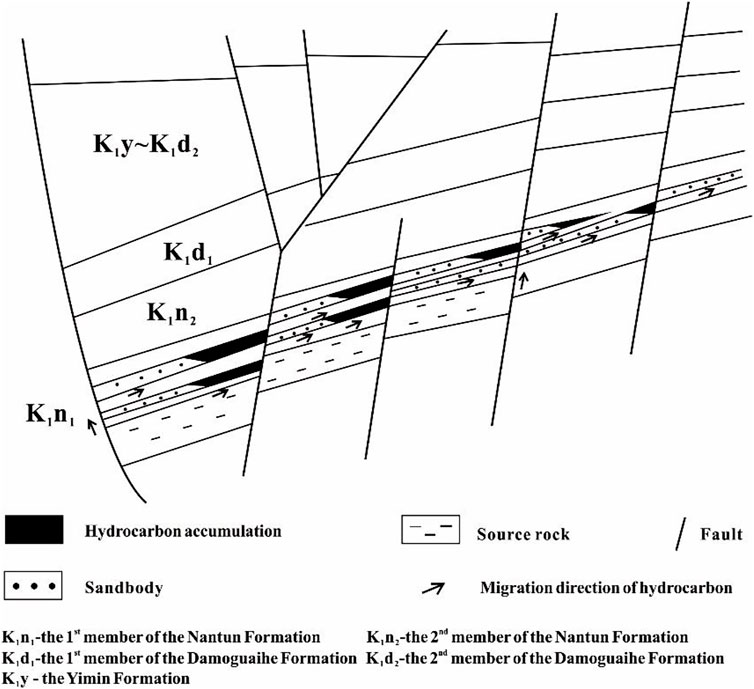
FIGURE 4. Schematic of the hydrocarbon accumulation model for the first member of the Nantun Formation (K1n1) in the Wunan slope area.
The sand ratio of the formation for the two oil formations in K1n1 are obtained from the drilling data. When combined with the hydrocarbon distribution for the Nantun Formation in this area (Figure 5A), the minimum value of sand ratio of the formation required for sand body connection is estimated to be about 19%. The distribution of the sand body connection area for these two oil formations in the Wunan slope area is also obtained (Figure 5B, Figure 5C). Except for a part of the central area, Figure 5B clearly shows that sand bodies of oil formation Ⅰof K1n1 in the Wunan slope area are all connected. The sand bodies of oil formation Ⅱ of K1n1 are also connected, except for parts of the central and northeastern area (Figure 5C). The burial depth of the top of the K1n1 formation is obtained from the paleo-burial depth reconstruction method (Fu et al., 2021) and corresponds to the paleo-burial depth of formation during the hydrocarbon accumulation period, i.e. the late sedimentary period of the Yimin Formation (Fu et al., 2013). The hydrocarbon paleo-potential energy value is calculated from Eq. 1. The distribution of the paleotectonic ridges that overlie the formation where the sand bodies are located is obtained from the hydrocarbon paleo-potential energy field. The distribution of the lateral migration paths of the hydrocarbons in K1n1 is obtained by superimposing the distribution of the sand body connection areas of K1n1 in Wunan slope area with the distribution of the paleotectonic ridges overlying the formation where the sand bodies are located (Figure 6). This figure suggests that there are seven lateral migration paths, from west to east, in the Wunan slope area. The three lateral migration paths of the hydrocarbon extend northward, and the four lateral migration paths of the hydrocarbon extend southward.
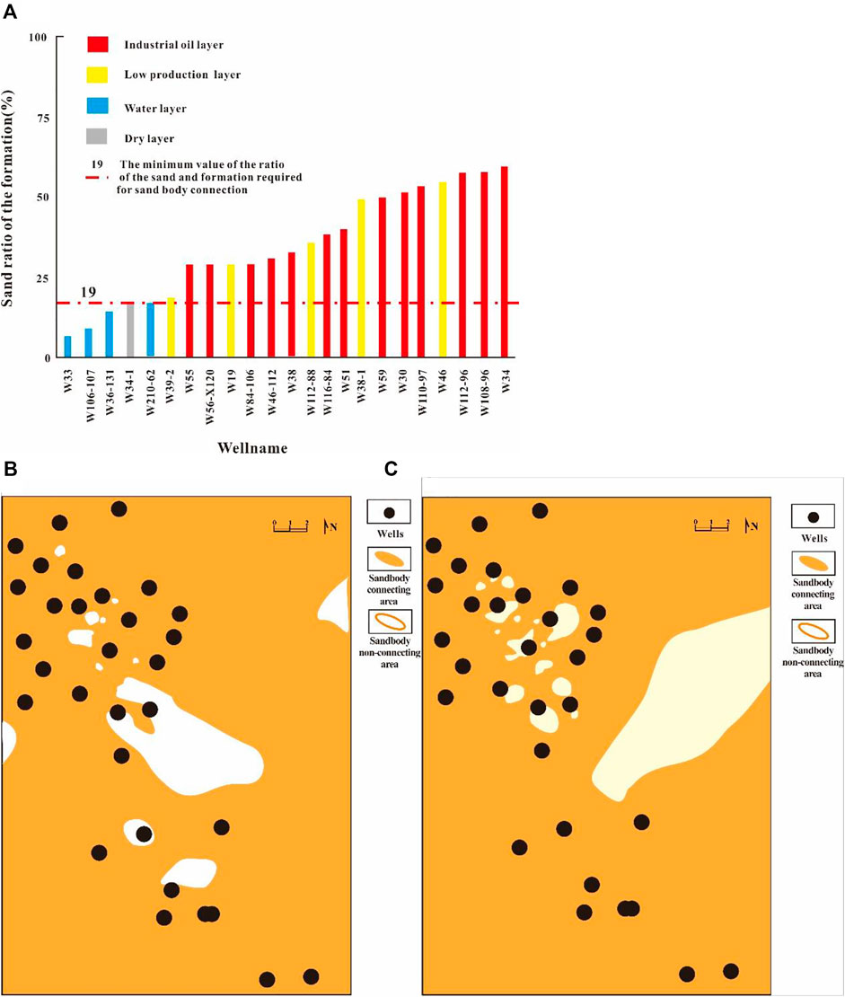
FIGURE 5. Determination of sand body connection distribution area for the first member of the Nantun Formation (K1n1) in the Wunan slope area; (A) The determination chart of the minimum value of the ratio of the sand and formation required for sand body connecting distribution in the Nantun Formation; (B) The sand body connecting distribution in oil formation Ⅰ of K1n1; (C) The sand body connecting distribution in oil formation Ⅱ of K1n1.
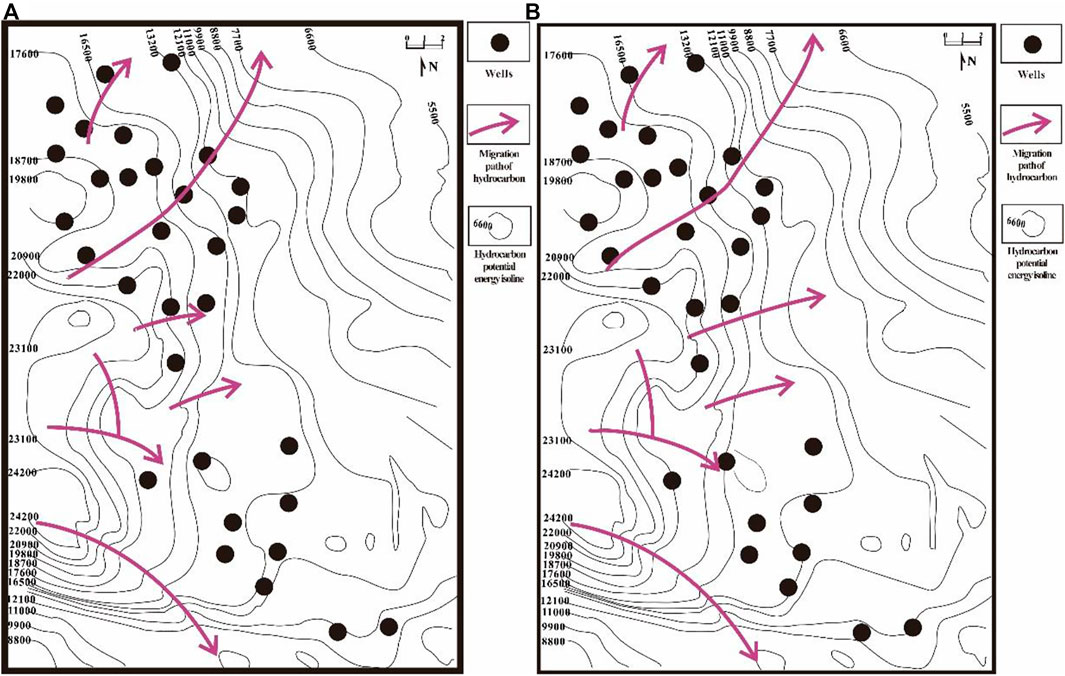
FIGURE 6. Distribution map with the lateral migration path of hydrocarbons in the first member of the Nantun Formation (K1n1) in the Wunan Slope Area; (A) Oil formation Ⅰ; (B) Oil formation Ⅱ.
The faults developed within K1n1 in the Wunan slope area are interpreted from 3D seismic data (Figure 7); the data suggests that a majority of the faults are oriented NW, a few are oriented NEE, and a small number are oriented in the N–S direction. Apart from in the western area, the faults are well-developed and widely distributed; the average density of faults is 0.4–0.5 per km. The fault distance in K1n1, the thickness of the rock formation and the argillaceous content (SGR) of the faulted formations are estimated from this 3D seismic data. Eq. 2 is used to calculate the argillaceous content of the faults in K1n1; the minimum argillaceous content of fault rocks required for hydrocarbon accumulation is estimated to be about 18%— from the relationship between the argillaceous content of the fault rocks at all known wells and the distribution of hydrocarbons in the area (Figure 8A). The fault lateral sealing of K1n1 in the Wunan slope area is evaluated accordingly (Figure 8B); it can be seen that almost all the faults are laterally sealed except for a few in the north.
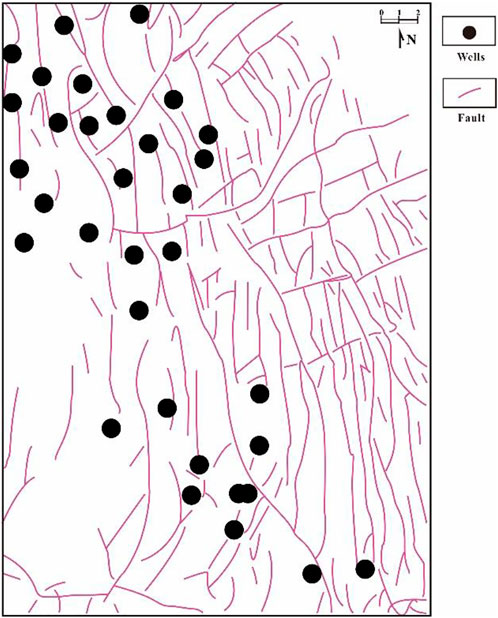
FIGURE 7. Fault distribution map of the first member of the Nantun Formation (K1n1) in the Wunan slope area.
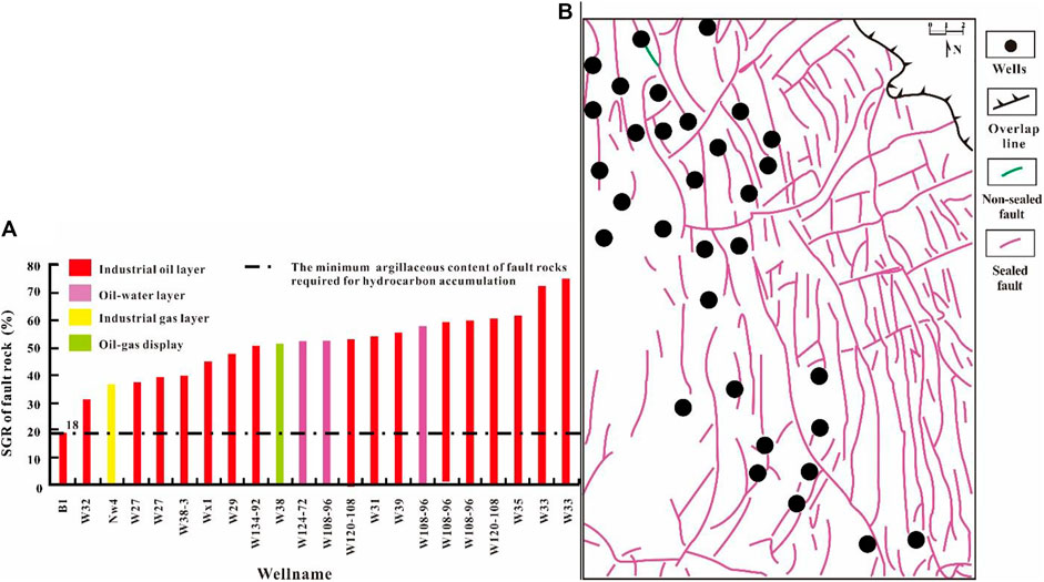
FIGURE 8. Evaluation map of lateral fault sealing of the first member of the Nantun Formation (K1n1) in the Wunan slope area; (A) The minimum argillaceous content of fault rocks required to close the fault; (B) The distribution of lateral sealing faults.
Sedimentary microfacies studies in the region suggest that the orientation of the channel sand body spread in the Wunan slope area is NNE (Figure 9). This is compared with the fault distributions that are perpendicular or oblique to channel sand bodies in the Wunan area (Figure 7 and Figure 9). The results show that the faults in K1n1 that are perpendicular or oblique to the river channel are mainly oriented NW and near-N–S; a few are oriented in the NE direction (Figure 10). Faults perpendicular or oblique to the channel sand bodies in the region are widely distributed, except for in the southwestern region—where they are not developed.
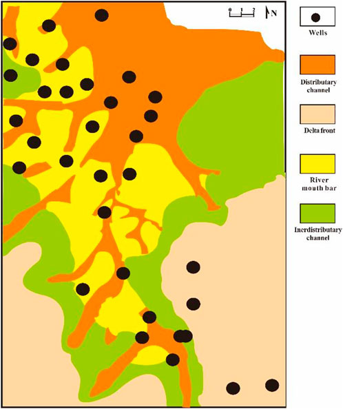
FIGURE 9. Channel sand body distribution map of the first member of the Nantun Formation (K1n1) in the Wunan slope area.

FIGURE 10. Distribution map of sealed faults in the first member of the Nantun Formation (K1n1) in the Wunan slope area oriented vertical or oblique to the channel sand body.
Effective sealing faults that aid hydrocarbon accumulation in K1n1 are widely distributed in the study area—except in the southwest, where these faults are not developed (Figure 8, Figure 10). The distribution of effective faults for hydrocarbon accumulation in K1n1 in the Wunan slope area are obtained by superimposing the distribution of the hydrocarbon lateral migration paths and the distribution of the effective sealing faults that support hydrocarbon accumulation (Figure 11). It can be seen that the effective faults for hydrocarbon accumulation are mainly distributed in the middle and northern part of K1n1; a comparatively smaller number of faults are distributed in the south-central part. Thus, oil formation Ⅰ has fewer effective faults for hydrocarbon accumulation in K1n1 than oil formation Ⅱ.
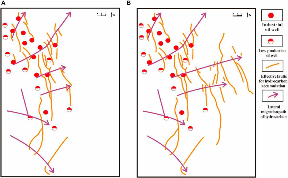
FIGURE 11. Relationship between hydrocarbon accumulating effective faults and hydrocarbon distribution in the first member of the Nantun Formation (K1n1) in the Wunan slope area; (A) Oil formation Ⅰ of K1n1; (B) Oil formation Ⅱ of K1n1.
The hydrocarbons discovered in K1n1 are mainly distributed in the middle and northern part of the Wunan slope area, near the effective faults for hydrocarbon accumulation (Figure 11). Here, hydrocarbons that accumulate near effective faults are obtained from the lateral migration of hydrocarbons from the source rocks of K1n1 of the western trough. Their accumulation is conditional on the configuration of the trap formed by the fault and sand body; they are found by drilling.
The lateral migration path of the hydrocarbons in the slope area were determined by identifying the sand body connection area, and the paleotectonic ridges overlying the formation where the sand body is located. By determining the lateral sealing part of the faults and faults that are perpendicular or oblique to the channel sand bodies, the effective faults for sealing hydrocarbons can be determined. The superimposition of these two methods creates a set of key methods to determine the effective faults for hydrocarbon accumulation in slope areas.
These methods were applied to effective faults determination in the Wunan slope area of the Wuerxun Depression in the Hailar Basin. The effective faults in K1n1 were identified mainly in the middle and northern part, with a smaller number distributed in the south-central part. This is conducive to hydrocarbon accumulation from the source rocks in K1n1 in the western trough given the nearby trap formed from fault and sand body configurations. This result is consistent with the discovery of hydrocarbons in K1n1 in the Wunan slope area, i.e., hydrocarbons are mainly located in the middle and northern part, and with a smaller volume in the center of the southern part.
These methods could be applied to sandy mudstone petroliferous basins to identify effective faults for hydrocarbon accumulation in slope areas.
The original contributions presented in the study are included in the article/supplementary material, further inquiries can be directed to the corresponding authors.
FZ, Writing—original draft, editing, Data curation, and Formal analysis. FG, Methodology and Data curation. FX, Methodology and Resources. WS, Methodology. XH, Data curation. FH, Methodology and Resources. GX, Resources.
We thank editors and reviewers for insightful comments in improving the manuscript.
The authors FZ, FX, WS, XH, and GX were employed by the Exploration and Development Research Institute of Daqing Oilfield Co Ltd. The author FH was employed by Petrochina Daqing Tamsag, LLC.
The remaining authors declare that the research was conducted in the absence of any commercial or financial relationships that could be construed as a potential conflict of interest.
All claims expressed in this article are solely those of the authors and do not necessarily represent those of their affiliated organizations, or those of the publisher, the editors and the reviewers. Any product that may be evaluated in this article, or claim that may be made by its manufacturer, is not guaranteed or endorsed by the publisher.
Fu, G., and Hu, X. L. (2016). Method of fault vertical sealing ability judged by the mudstone content of fault-rock and its application. J. Earth Sci. Environ. 38 (5), 660–667. doi:10.3969/j.issn.1672-6561.2016.05.009
Fu, G., Shi, J. J., and Lyu, Y. F. (2012). An improvement in quantitatively studying lateral seal of faults. Acta Pet. Sin. 33 (3), 414–418. doi:10.7623/syxb201203010
Fu, G., Shi, J. J., and Lyu, Y. F. (2013). Study of ancient displacement pressure of fault rock recovery and its sealing characteristics. J. China Univ. Min. Technol. 42 (6), 996–1001. doi:10.13247/j.cnki.jcumt.2013.06.018
Fu, G., Sun, T. W., and Lyu, Y. F. (2014). An evaluation method of oil-gas lateral transporting ability of fault-sandstone configuration in Nanpu depression. J. China Univ. Min. Technol. 43 (1), 79–87. doi:10.13247/j.cnki.jcumt.000016
Fu, G., and Wang, H. (2018a). Differences of distribution characteristics of oil and gas by the control of fault-sand transporting system in uplifted area and slope area. J. China Univ. Petroleum Ed. Nat. Sci. 42 (3), 22–30. doi:10.3969/j.issn.1673-5005.2018.03.003
Fu, G., and Wang, H. (2019). Prediction method of favorable position in oil-gas accumulation around oil-source. Geotect. Metallogenia 43 (1), 69–76. doi:10.16539/j.ddgzyckx.2019.01.006
Fu, G., and Zhan, M. W. (2016). Geological conditions for lateral sealing of active faults and relevant research methods. Nat. Gas. Ind. 36 (10), 28–34. doi:10.1016/j.ngib.2017.07.008
Fu, G., Guo, H. Y., and Han, X. (2021). A prediction method of favorable positions of transporting oil and gas capacity configuration in different periods of faults. Natural Gas Geosci. 32 (1), 28–37. doi:10.11764/j.issn.1672-1926.2020.10.003
Henares, S., Caracciolo, L., Cultrone, G., Fernandez, J., and Viseras, C. (2014). The role of diagenesis and depositional facies on pore system evolution in a Triassic outcrop analogue (SE Spain). Mar. Petroleum Geol. 51, 136–151. doi:10.1016/j.marpetgeo.2013.12.004
Hu, C. M., Fu, G., and Zhan, M. W. (2018). Hydrocarbon upward uigration condition in different directions and prediction method of distribution area. Geol. Rev. 64 (1), 227–236. doi:10.16509/j.georeview.2018.01.017
Jin, Z. J. (2012). Formation and accumulation of oil and gas in marine carbonate sequences in Chinese sedimentary basins. Sci. China Earth Sci. 55, 368–385. doi:10.1007/s11430-011-4264-4
Li, D., He, D. F., Lian, Y., Lu, Y., and Yi, Z. (2017). Structural evolution and late carboniferous magmatism of the zhongguai arc in the Western junggar basin, northwest China: Implications for tectonic evolution of the junggar ocean. Int. Geol. Rev. 59 (10), 1234–1255. doi:10.1080/00206814.2016.1160801
Lyu, Y. F., Wang, W., Hu, X. L., Fu, G., Shi, Y. F., and Wang, J. J. (2016). Quantitative evaluation method of fault lateral sealing. Petroleum Explor. Develop. 43 (2), 310–316. doi:10.11698/PED.2016.02.20
Meng, Q., Bai, X. F., Zhang, W. J., Fu, L., Xue, T., and Bao, L. (2020a). Accumulation and exploration of petroleum reservoirs in west slope of northern Songliao Basin, China. Petroleum Explor. Dev. 47 (2), 254–265. doi:10.1016/S1876-3804(20)60044-1
Wang, C., Lyu, Y. F., Fu, G., Wang, Y. G., Liu, Z., Sun, T. W., et al. (2017). Ancient lateral sealing evaluation method of fault and its application in hydrocarbon accumulation period. Earth Sci. 42 (10), 1787–1801. doi:10.3799/dqkx.20117.549
Wang, H. R., Fu, G., Su, B., Sun, T. W., and Tang, W. H. (2018b). A method to determine preferential pathways for hydrocarbon migration in “lower source rock and upper reservoir” combination and its application. Oil Gas Geol. 39 (6), 1237–1245. doi:10.11743/ogg20180613
Wang, J. W., Song, G. Q., Song, S. J., Wang, X. Z., and Gao, X. (2009). Controlling factors for petroleum dominant lateral migration along Eogene carrier beds in southern slope of Dongying sag. J. China Univ. Petroleum Ed. Nat. Sci. 33 (5), 36–40. doi:10.1016/j.postharvbio.2008.09.010
Wu, K. J., Liu, L. F., Xiao, F., Zhou, C. X., and Xu, Z. J. (2015). Characteristics of the hydrocarbon pathway system and transport model of the Chepaizi and its surrounding areas in the Junggar basin of China. J. China Univ. Min. Technol. 44 (1), 86–96. doi:10.13247/j.cnki.jcumt.000119
Yang, X., Ji, H. C., Dou, L. R., Du, Y. B., Jia, H. B., Chen, L., et al. (2020b). Tectono-sedimentary characteristics in the area with distributed normal faults: Lower Cretaceous Prosopis Formation in the northern slope of Bongor Basin, Chad. J. Petroleum Sci. Eng. 190, 107081. doi:10.1016/j.petrol.2020.107081
Zhang, J., Fu, G., and Song, D. L. (2018). Lateral migration hydrocarbon identification in fault-sand configuration. Oil Geophys. Prospect. 53 (05), 1041–1048. doi:10.13810/j.cnki.issn.1000-7210.2018.05.018
Zhou, Q. H., Lyu, Y. F., Fu, G., Zhou, Q. Q., and Jiang, L. (2006). The pool-forming pattern and main control factors in west slope of the north of songliao basin. Nat. Gas. Geosci. 6, 765–769. doi:10.11764/j.issn.1672-1926.2006.06.765
Zhu, G. Y., Zou, C. N., Yang, H. J., Wang, K., Zheng, D. M., Zhu, Y. F., et al. (2015). Hydrocarbon accumulation mechanisms and industrial exploration depth of large-area fracture–cavity carbonates in the Tarim Basin, Western China. J. Petroleum Sci. Eng. 133, 889–907. doi:10.1016/j.petrol.2015.03.014
Keywords: slope area, hydrocarbon accumulation, effective faults, determination method, wunan slope area, the 1 st member of the nantun formation (K1n1)
Citation: Zili F, Guang F, Xiaodong F, Shuli W, Hongwei X, Hongjun F and Xiaobo G (2023) Determining effective faults for hydrocarbon accumulation in slope areas of petroliferous basins: Methods and applications. Front. Earth Sci. 10:1052611. doi: 10.3389/feart.2022.1052611
Received: 24 September 2022; Accepted: 10 November 2022;
Published: 10 January 2023.
Edited by:
Wenlong Ding, China University of Geosciences, ChinaReviewed by:
Quanzhong Guan, Chengdu University of Technology, ChinaCopyright © 2023 Zili, Guang, Xiaodong, Shuli, Hongwei, Hongjun and Xiaobo. This is an open-access article distributed under the terms of the Creative Commons Attribution License (CC BY). The use, distribution or reproduction in other forums is permitted, provided the original author(s) and the copyright owner(s) are credited and that the original publication in this journal is cited, in accordance with accepted academic practice. No use, distribution or reproduction is permitted which does not comply with these terms.
*Correspondence: Fan Xiaodong, ZmFueGRkcUBwZXRyb2NoaW5hLmNvbS5jbg==; Fu Hongjun, NjM5NzA1OTdAcXEuY29tJiN4MDIwMGE7
Disclaimer: All claims expressed in this article are solely those of the authors and do not necessarily represent those of their affiliated organizations, or those of the publisher, the editors and the reviewers. Any product that may be evaluated in this article or claim that may be made by its manufacturer is not guaranteed or endorsed by the publisher.
Research integrity at Frontiers
Learn more about the work of our research integrity team to safeguard the quality of each article we publish.