 Peijie Yang1,2
 Yulong Dong
94% of researchers rate our articles as excellent or good
Learn more about the work of our research integrity team to safeguard the quality of each article we publish.
Find out more
ORIGINAL RESEARCH article
Front. Earth Sci., 17 January 2023
Sec. Geohazards and Georisks
Volume 10 - 2022 | https://doi.org/10.3389/feart.2022.1010134
This article is part of the Research TopicGeological Disasters in Deep Engineering Mechanism, Warning and Risk mitigationView all 39 articles
Land subsidence is an environmental geological phenomenon with slowly decreasing ground elevation, The North China Plain is one of the areas with the most serious land subsidence in China, and Guangrao County is one of the subsidence centers. This paper is based on the hydrogeological and engineering geological data of Guangrao County, the groundwater monitoring data for many years and the land subsidence monitoring data, systematically analyzes the dynamic characteristics of groundwater, the distribution and evolution of land subsidence, and the correlation between groundwater exploitation and land subsidence development in different layers of this area. Based on Biot porous medium consolidation theory, establishes a three-dimensional fluid solid coupling numerical model of land subsidence in Guangrao County, restores the development process of land subsidence, predicts and analyzes the subsidence evolution law under different groundwater exploitation schemes, and proposes targeted prevention and control measures. The research results show that: the shallow groundwater forms a cone of depression with Guangbei Salt Field as the center, and the deep groundwater forms an elliptical regional cone of depression with the urban area as the center. The ground is gradually formed two small settlement areas with the urban area of Guangrao County and Guangbei Salt Field as the settlement center, and there is a trend of interrelated expansion. The three-dimensional fluid solid coupling model of land subsidence accurately restored the development process of land subsidence in the study area, predicted that under the current groundwater exploitation conditions, by 2040, the settlement of Guangrao urban settlement center will increase to 1,350 mm, forming a large regional funnel centered around the urban area, and gradually developing and expanding around. Prohibition of groundwater exploitation in the main funnel area is a more reasonable and effective exploitation plan to prevent the development of land subsidence.
Land subsidence is an environmental geological phenomenon that the regional ground elevation decreases slowly due to the consolidation and compression of the surface soil of the crust caused by natural or human factors. It has the characteristics of slow growth, long duration, expansive influence, complex genesis mechanism, and difficult prevention and control (Xue et al., 2003), (Xue et al., 2006), (Ora et al., 2019). The main causes of land subsidence are the development and utilization of underground fluid resources (groundwater, oil, natural gas, etc.), geological structure subsidence, solid mineral exploitation and engineering environmental effects, and overexploitation of groundwater is widely considered to be the most important cause of land subsidence (Liu, 2001), (Galloway and Burbey, 2011). The impact of land subsidence is mainly reflected in four aspects: 1) damage to infrastructure such as pipelines, buildings and dams (Sarah et al., 1779); 2) causing the deformation of pavement and railway foundation, and affect the service capacity of highway and railway; 3) increasing the risk of flooding (Du et al., 2018); 4) a potential channel for ground pollution sources to penetrate into the underground, causing groundwater pollution (Hussain and Abed, 2019).
Since the first discovery of land subsidence in Mexico City in 1891 (Ortega-Guerrero et al., 1999), land subsidence has been found in Ravenna and Venice in Italy (Antonellini et al., 2019), Tokyo and Osaka in Japan (Inaba et al., 1970), San Joaquin Vally and Santa Clara in the United States (Tolma and Poland, 1940), (Jeanne et al., 2019), Bangkok in Thailand (Phien-Wej et al., 2006), Jakarta in Indonesia (Abidin et al., 2011), Saudi Arabia (Othman and Abotalib, 2019), Kathmandu Watershed in Nepal and other regions (Shrestha et al., 2017), and has carried out relevant exploration and research. In China, the earliest record of land subsidence disaster was in Shanghai in 1923 (Zhang and Wei, 2002). Subsequently, land subsidence was found and became increasingly serious in whole the country. The Yangtze River Delta represented by Shanghai and Suzhou Wuxi Changzhou (Li and Wang, 2006), the North China Plain represented by Beijing, Tianjin, Hebei and Shandong (Zhang, 2014), and the Fenwei Basin represented by Xi’an (Wang et al., 2014) are the regions most affected by land subsidence in China, They have invested in a lot of research and achieved many research results.
The North China Plain is among the area with the most serious overexploitation of groundwater in the world, and also the area with the largest land subsidence funnel and the largest subsidence coverage area (He et al., 2006). As an important part of the land subsidence funnel in the North China Plain, the land subsidence in northern Shandong Province is particularly serious. The land subsidence phenomenon in Shandong mainly occurs in Dongying, Dezhou, Binzhou and Weifang, relevant scholars have carried out some research work in Dezhou, Binzhou and other regions (Jia et al., 2015). At present, no scholar has systematically analyzed and studied the land subsidence in Guangrao, Dongying. According to the relevant data of the Dongying land subsidence monitoring network established in 2002, the deep groundwater level in Guangrao County has continued to decline for many years, and the land subsidence rate has not slowed down.
At present, the research on land subsidence mainly focuses on the following aspects: 1) study the settlement mechanism of land subsidence and analyze its related influencing factors (Ji et al., 2019); 2) Investigate on land subsidence disasters, and expand to the secondary disasters caused by land subsidence, such as ground fissures, land collapse, urban waterlogging and water logging (Qin et al., 2018), (Jia et al., 2019); 3) Carry out research on the simulation and prediction of land subsidence, from simple qualitative prediction of single factor to quantitative prediction of multiple models with comprehensive effect of multiple factors (Luo et al., 2018); 4) In terms of land subsidence monitoring technology, make the subsidence monitoring results more accurate and intuitive by expanding from a single leveling method to a variety of monitoring means such as InSAR and GPS using satellite remote sensing technology (Xue et al., 2021); 5) In terms of the prevention and control measures of land subsidence, change the previous mode of discovering disasters—managing them to predicting—controlling disasters (Li et al., 2021).
For the calculation of land subsidence caused by pumping, the current research focuses more on the study of soil constitutive relationship or fluid solid coupling effect with characteristics such as soil creep and parameter time variation, so as to propose the characteristics and laws of soil deformation under different hydraulic conditions. However, for regional land subsidence, due to the existence of a large number of pumping wells, the pumping horizon and pumping volume are different. When conventional numerical analysis methods are used to deal with the boundary conditions of the pumping wells, the grid division is too dense, which will lead to a huge amount of calculation. However, the simplified processing also affects the calculation accuracy, and cannot reasonably and accurately reflect the development characteristics of regional land subsidence based on different pumping information of pumping wells, and predict its development trend.
Therefore, this paper takes Guangrao County, Dongying City, North China Plain as the study area, fully learns from and absorb the research achievements of land subsidence at home and abroad, widely collects the hydrogeology and engineering geology of Guangrao County, the monitoring data of groundwater for many years and the monitoring data of land subsidence over the years, uses the effective stress theory, deeply analyzes the formation mechanism of land subsidence in Guangrao County. Using Biot consolidation fluid solid coupling theory, establishes a three-dimensional porous medium fluid solid coupling numerical model for land subsidence in Guangrao County. Using the line source mass flux method, simulates the production volume of each pumping well, accurately depicts the hydraulic boundary conditions of hundreds of pumping wells with different production horizons and different production volumes in the area. Through numerical analysis, accurately restores the evolution law of land subsidence caused by groundwater exploitation in this area. At the same time, through the design of different groundwater exploitation schemes, predicts the development of land subsidence and proposes effective prevention and control measures. It provides theoretical basis and data support for land subsidence prevention in this area.
Guangrao County is located in the north of the central part of Shandong Province (Figure 1). The geographical coordinates are 118°17′∼118°57′ east longitude and 36°56′∼37°21′ north latitude, with a gross area of 1,166 square kilometers. The northeast of the study area is adjacent to Laizhou Bay of Bohai Sea, with a coastline of 12.35 km. The county is located in the overlapping zone of Mount Tai Yi northern foot piedmont alluvial plain and the Yellow River flood plain. The area terrain gradually inclines from southwest to northeast. The highest elevation in the southwest is 28 m, and the lowest elevation in the northeast is 2 m. The natural slope is 1/1,000∼1/2000. The study area has a monsoon climate, and there is no significant difference in the climate within the territory. The annual average precipitation is about 587 mm, mainly from June to September.
FIGURE 1. Geographical location of the study area.
According to the hydrogeological and engineering geological survey data of the study area, the groundwater system in the area is composed of shallow phreatic water micro confined water system (buried depth 0∼60 m), medium and deep confined water system (buried depth 60∼250 m), and deep confined water system (buried depth >250 m). The buried depth of shallow groundwater level varies greatly, and its distribution characteristics are roughly bounded by Xiaoqing River. The south of Xiaoqing River is mostly well irrigation area, the buried depth of the water level is large, and the main supply source is atmospheric precipitation, followed by river leakage supply, irrigation infiltration supply and runoff supply, and the discharge way is mainly manual pumping. Generally, The year presents the dynamic characteristics of “two peaks and one valley”. From March to April, the spring irrigation starts, and the groundwater is recharged by irrigation infiltration. The water level has its first peak in the year. Later, the water level drops due to continuous pumping, the lowest water level in the year occurs in June. In July, with the arrival of the rainy season, the groundwater is recharged by precipitation infiltration, and the water level has its second peak in the year. Due to the large buried depth of water level and the insufficient intensity of single precipitation, it is difficult for precipitation to effectively recharge groundwater. Therefore, the second peak of water level in the rainy season of 2015–2017 is not obvious. The annual variation of water level affected by artificial exploitation is large, generally more than 10 m. In recent years, the water level continues to return due to the policy of reducing groundwater exploitation (Figure 2). The buried depth of water level in the north of Xiaoqing River is small, the upper soil permeability is good, and it is greatly affected by precipitation and evaporation intensity. The phreatic water is mainly in vertical movement, which is mainly supplied by precipitation infiltration, followed by the Yellow River lateral infiltration and irrigation infiltration; It has the characteristics of direct infiltration replenish, direct excretion, intermittent replenish and continuous excretion; Generally, the lowest water level in the year is reached before the rainy season, and the highest water level in the year is reached in the rainy season. The annual variation is generally less than 2 m (Figure 3). The water level of middle and deep groundwater is very weakly affected by the atmosphere, but mainly affected by artificial exploitation; Generally, the lowest water level occurs during the peak period of water use in summer, and the highest water level occurs during the Spring Festival holiday (Figure 4). In addition, there are 12 rivers in the study area, they belong to the two major water systems of Xiaoqing River and Zhimai River respectively, mainly including Xiaoqing River, Zihe River, Zhimai River, Zhinv River, Yang River, spillway river and preparatory river.
FIGURE 2. Relationship between shallow groundwater dynamics and precipitation in the south of Xiaoqing River.
FIGURE 3. Relationship between shallow groundwater dynamics and precipitation in the north of Xiaoqing River.
FIGURE 4. Relationship between deep groundwater dynamics and annual exploitation.
The hydrogeological conditions and water system distribution in Guangrao County are different from north to south, and the spatial distribution of water resources is also different. The shallow and deep groundwater in the southern well irrigation area is relatively abundant, with good water quality, convenient water intake and stable water supply. However, overexploitation of groundwater for many years has led to a continuous and substantial decline in the groundwater level, causing geological environmental problems such as salt water intrusion and ground fissures. The shallow groundwater in the northern region is brackish water and saline water. Only the deep confined fresh water can be used. The amount of resources is, however, limited, and it is difficult to replenish. The fluorine content of water quality generally exceeds the standard of drinking water, and the development potential is limited. In the north, there are Xiaoqing River, Zhimai River and Yellow River. The surface water is relatively abundant, and the diversion of the Yellow River is relatively convenient.
The first land subsidence leveling survey was carried out in Dongying City in 2002. According to the monitoring data of land subsidence for many years, there is widespread land subsidence in Dongying City, of which Guangrao urban area is one of the subsidence centers, and the cumulative subsidence of the subsidence center is more than 1.5 m (Figure 5), from 2017 to 2021, the area with accumulated subsidence more than 300 mm is 647.81-square-kilometres.On the whole, the development trend of land subsidence in the main urban area and coastal areas of Guangrao County is the most obvious, with an average annual settlement rate of 135.1 mm. The amount of land subsidence in Guangrao County is increasing year by year and developing rapidly. The Development Zone in the north of the city and the coastal area in the East have formed a relatively obvious subsidence funnel. The land subsidence funnel is constantly expanding and connecting with other small funnels, and there is a trend to form a large regional land subsidence funnel, It has had a significant impact on local urban planning and construction, social and economic development and people’s lives (Yang, 2014), (Zhang et al., 2018), (Liu et al., 2014).
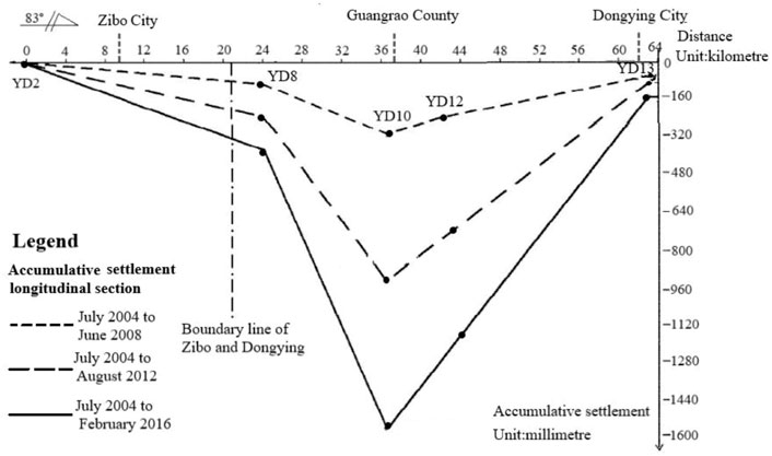
FIGURE 5. Land subsidence accumulative settlement of longitudinal section of Guangrao.
Both groundwater funnel and land subsidence are caused by the reduction of water level in the pumping area due to excessive exploitation of groundwater, and the occurrence time of funnel is synchronized with the occurrence of land subsidence, so it is closely related to the occurrence of land subsidence. The contour lines of groundwater funnel level and land subsidence in different aquifers are drawn by GIS software, and they are superimposed for analysis.
The center of shallow groundwater funnel is located in Dawang Town-Xiliuqiao Village- Damatou Town and Guangbei salt field. The buried depth of the central water level is 50∼56 m, The funnel area with -30 m constant water level coil closed is about 393.32 square kilometers, There are also the serious land subsidence area in the above areas, and the points with the largest subsidence rate are located in the funnel range, the average settlement rate for many years is 102mm/a. This shows that the land subsidence in these areas is closely related to the exploitation of shallow groundwater (Figure 6). The development and utilization of groundwater in the middle layer is low, and there is no groundwater funnel, so it has little correlation with land subsidence (Figure 7). The center of deep groundwater funnel is located in Guangrao urban area, and the buried depth of the central water level is 118∼121 m, The funnel area with −70 m constant water level coil closed is about 428.65 square kilometers, At the same time, there is also a Serious Land Subsidence Area in this area. The point with the largest subsidence rate is located in the funnel range, and the average settlement rate for many years is 131.5 mm/a. The deep groundwater funnel in this area basically coincides with most settlement funnel areas (Figure 8); The analysis shows that the land subsidence here is mainly induced by the exploitation of deep groundwater. Pumping reduces the pore water pressure and increases the effective stress, which leads to land subsidence.
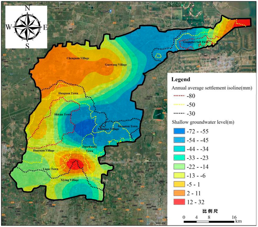
FIGURE 6. Superimposed chart of land subsidence and shallow groundwater funnel development.
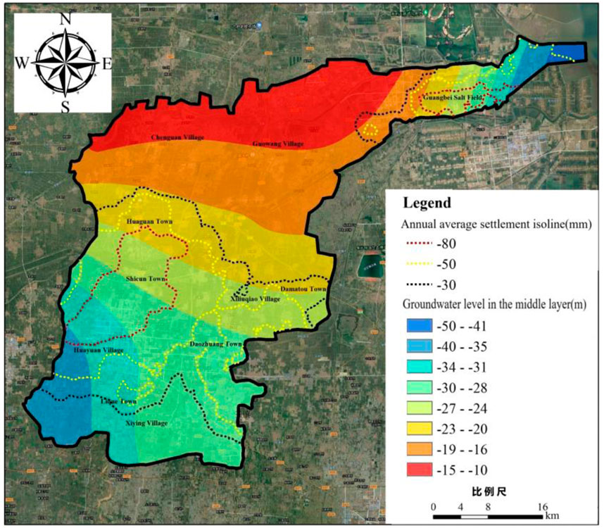
FIGURE 7. Superimposed chart of land subsidence and middle layer groundwater funnel development.
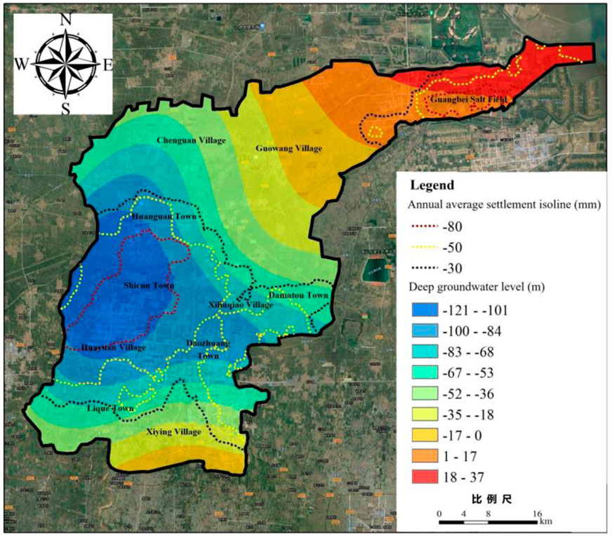
FIGURE 8. Superimposed chart of land subsidence and deep layer groundwater funnel development.
According to the field survey of Guangrao County, combined with the flow field of shallow, middle and deep groundwater and the distribution of land subsidence, the influencing factors of land subsidence in each funnel area are shown in Table 1.
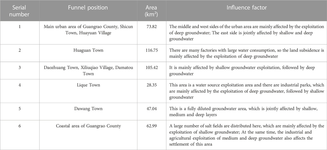
TABLE 1. Correlation between ground subsidence and groundwater in each aquifer in Guangrao County.
The consolidation settlement of soil mass due to water loss is a typical fluid-solid coupling process in porous media, which is microscopically described as the coupling of seepage field and stress field (Jia et al., 2019). Based on groundwater seepage theory and soil consolidation theory, a three-dimensional fluid-solid coupling numerical model of land subsidence is established to predict the evolution trend of land subsidence induced by groundwater exploitation in the study area (Luo et al., 2018) (Xue et al., 2021).
In the coupling model of groundwater flow and porous media, by considering the coupling relationship between pore water pressure dissipation and skeleton deformation in the process of water loss consolidation of soil, derives the three-dimensional consolidation equation of soil with time varying average total stress, gives the stress-strain constitutive relationship in the form of tensor:
where,
The equilibrium equation of porous media under self weight load is:
where,
Geometric equation of deformation of porous media material through its total strain tensor
For fluid motion, the flow field equation in the porous medium model can be established by combining Darcy’s law and the fluid mass conservation equation:
Where,
In the model, for the simulation of pumping wells, the method of one-time application of water level boundary conditions can be used to directly apply the water level change or water pressure change after pumping to the boundary of the pumping well model, or the pumping rate can be applied to the wall model of the corresponding pumping horizon in the model. This method is only applicable to the non-point source pumping wells, and the boundary conditions are:
The third method is to use the mass flux method to directly apply the pumping volume to the edge of the model of the production well, including the model of the non-point source production well and the line source production well, and its effect is equivalent to the pumping rate. The boundary conditions are:
In this study, according to the formation conditions, groundwater data, drilling data and relevant data of pumping well location in the study area, the strata are divided into 4 aquitards and 3 aquifers (Figure 9). The soil parameters of each layer are obtained according to the relevant engineering geological survey reports in the study area and combined with the empirical data on Soil in the [Engineering Geology Manual (Fifth Edition)] (Hua and Zheng, 2017) (Table 2).
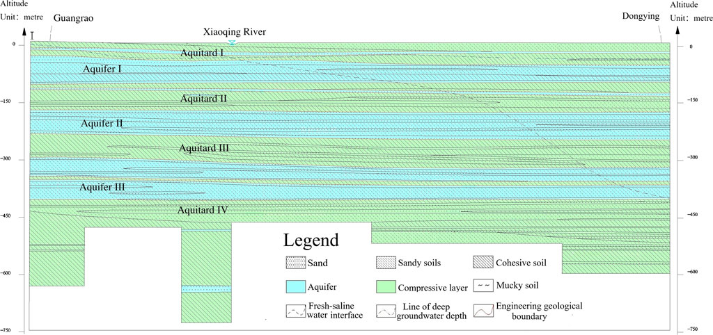
FIGURE 9. Guangrao County division of engineering geological characteristic layers.
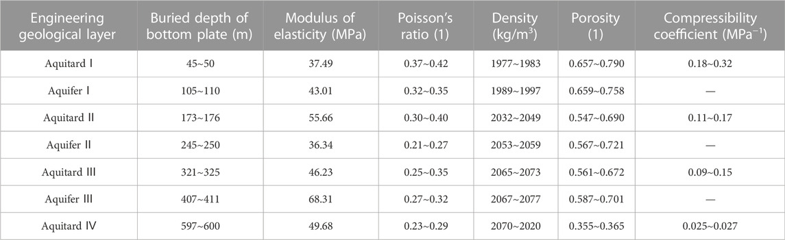
TABLE 2. Physical and mechanical parametres of each layer (range).
The boundary conditions are defined as follows: the flow boundary is used around the study area, and the hydraulic change conditions are obtained by analyzing and calculating the dynamic evolution of groundwater flow field, while limiting the horizontal movement and vertical free sliding; The surface is a zero flow boundary and a free moving boundary; The bottom is a zero flow boundary with fixed displacement in horizontal and vertical directions; The pumping well adopts the flow boundary condition, which converts the actual production into the unit mass flux to limit the horizontal displacement and the vertical free movement. The model boundary is composed of multiple line segments connected with each other, which is equivalent to the actual boundary. Mesh division adopts free subdivision tetrahedral mesh. The numerical model of land subsidence in Guangrao County, Dongying City is divided into 117,538 domain elements, 49,989 boundary elements and 3,994 boundary elements. The numerical model and mesh division are shown in Figure 10.
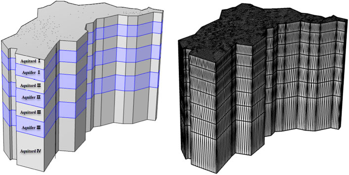
FIGURE 10. Three dimensional fluid solid coupling numerical model of land subsidence in Guangrao County.
Based on the existing InSAR settlement data and GIS spatial analysis technology, the distribution chart of cumulative land subsidence in Guangrao County, Dongying City, Shandong Province from 2017 to 2021 was obtained (Figure 11). Taking 2017 to 2021 as the model validation period, the land subsidence of Guangrao County during this period was simulated by using a three-dimensional numerical model (Figure 12). Through comparative analysis:
1) The spatial ranges of the land subsidence area obtained by the two methods are highly coincident. The model calculates that the area of the settlement area with the accumulated settlement >300 mm is 606-square-kilometres, which differs with the InSAR interpretation area by 6.9%. The settlement range includes the south of Huaguan Town, Shicun town and Huayuan Village, and there is also a certain settlement funnel in the Northeast coastal area.
2) The funnel centers obtained by the two methods is the same. In the region, Regionally Guangrao city is the funnel center, and the small settlement funnel in the Northeast coastal area is the Guangbei salt field.
3) The settlement rates obtained by the two methods are similar. The simulated accumulated settlement of the land subsidence center in 48 months is 498 mm, and the average annual settlement rate for many years is 124.5 mm; According to InSAR interpretation, the accumulated settlement in 48 months is 526 mm, and the average annual settlement rate is 131.5 mm, thus the difference between them is 5.6%
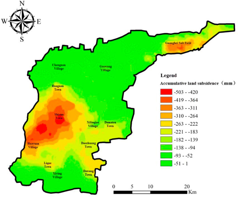
FIGURE 11. distribution chart of land subsidence in Guangrao County, Dongying City (2017–2021).

FIGURE 12. | Numerical simulation of land subsidence in Guangrao County, Dongying City (2017–2021).
From the comparison of numerical simulation results with InSAR Data, it can be concluded that the simulation effect of land subsidence in this period is relatively ideal, which can reflect the actual settlement trend of the region during this period.
At present, there are 11 monitoring points in Guangrao County, Dongying City, and the monitoring data are the four-year cumulative settlement from 2017 to 2021. Among them, The actual effective monitoring data are 20, 55, 63 and 68 points, which are distributed in Lique Town, Shicun town and Daozhuang town (Figure 13). The actual settlement of each effective monitoring control point is statistically compared with the three-dimensional fluid solid coupling numerical simulation results. The results are shown in Table 3.

FIGURE 13. Distribution of effective monitoring points.
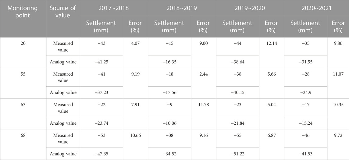
TABLE 3. Comparison between actual monitoring values and numerical simulation results of some settlement monitoring points in Guangrao County, Dongying City.
Comparing the actual measured values of each monitoring point with the simulated values from three-dimensional fluid-solid coupling numerical model, it can be found that the simulated values are in good agreement with the measured values. The minimum absolute simulation error is 2.44%, and the maximum absolute simulation error is 12.14%. The results of the two coincide well, which shows that the numerical model of land subsidence can reflect reliably the development and evolution trend and law of land subsidence in this area.
Based on the calibrated three-dimensional fluid solid coupling numerical model of Guangrao land subsidence, taking the land subsidence of Guangrao County in 2017 as the initial state, restores the evolution process and development law of land subsidence in the region during 2017∼2020, Figures 14A–C show the land subsidence development of Guangrao County in 2017–2018, 2018–2019 and 2019–2020 respectively. It can be seen from the analysis in the figure that the land subsidence in Guangrao County will decrease first and then increase during 2017–2020, the land subsidence from 2017 to 2018 is a stage of rapid development, the development rate from 2018 to 2019 has slightly decreased, but it still maintains a rapid development. After 2019, the land subsidence develops rapidly. On the whole, the development trend of land subsidence in the urban area and coastal area of Guangrao County is the most obvious, with the average annual subsidence rate of 135.1 mm/a and 102 mm/a, respectively. The Open Economic Zone and Guangbei salt field have formed obvious subsidence funnels. The land subsidence funnels are expanding and connecting other small funnels, forming a large regional land subsidence funnels.
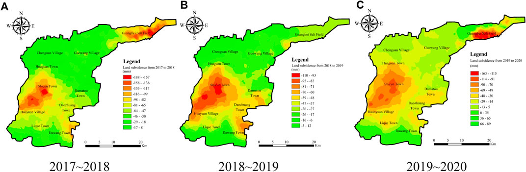
FIGURE 14. Evolution trend of land subsidence in Guangrao County.
By restoring the development process of land subsidence in Guangrao, and combining the statistical information such as distribution of mining wells, mining horizon, and mining volume in the study area, and dynamic distribution characteristics of groundwater. It is found that the main exploitation horizon of groundwater in the urban area of Guangrao County is the fourth and fifth deep groundwater aquifers, which is consistent with the deep groundwater funnel of Guangrao County. Therefore, it is believed that the land subsidence in the urban area of Guangrao County is mainly related to the exploitation of deep groundwater in the fourth and fifth aquifers. Guangbei Salt Field has a large number of brine exploitation wells, The main mining horizon is the second and third aquifers, and the distribution of land subsidence coincides with the distribution of shallow brine funnels. Therefore, it is considered that the land subsidence in Guangbei Salt Field area is relatively related to the mining of shallow brine.
Based on the established three-dimensional fluid-structure coupling numerical model of land subsidence in Guangrao County, the land subsidence trend and rule in Guangrao County in the next 20 years were simulated, calculated and predicted under the condition of maintaining the current pumping conditions and reducing groundwater extraction, and targeted groundwater prevention and control schemes and measures were proposed.
Using the established three-dimensional fluid-solid coupling numerical model of land subsidence in Guangrao area, assuming that the current groundwater exploitation conditions remain unchanged, the land subsidence and groundwater exploitation in 2021 are taken as the initial state to predict the change trend and regulation of land subsidence in the study area in the next 20 years. Our analysis shows that if the current pumping state is maintained, the land subsidence in Guangrao area will continue and increase much more in the next 20 years, by 2025, the maximum settlement of funnel center in Guangrao city will be 784 mm (a), by 2030, the maximum settlement will increase to 1040 mm(b), by 2035, the maximum settlement will be 1220 mm(c), By 2040, the maximum accumulated land subsidence in the study area will reach 1,350 mm, more than three times the maximum accumulated land subsidence in 2021(d). However, the ground subsidence funnel centered on Guangbei Salt Field will gradually recover in the future due to less brine exploitation in recent years. The results are shown in Figure 15.
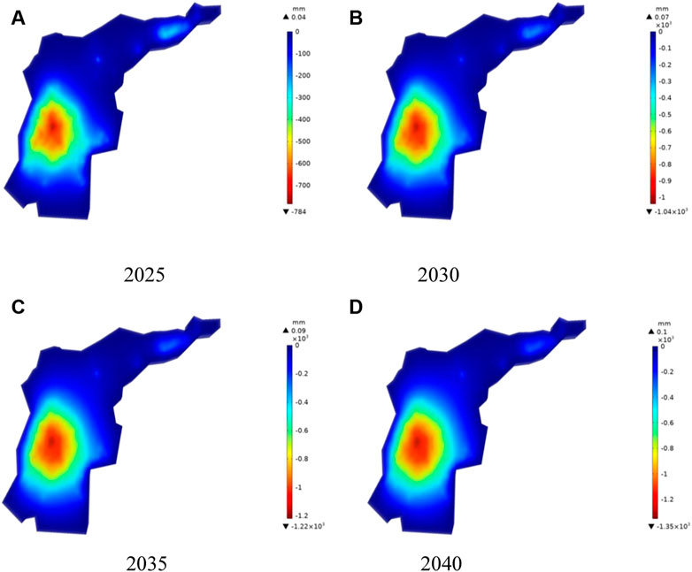
FIGURE 15. The evolution trend of land subsidence in different periods.
Maintain the current groundwater exploitation, and by 2040, the land subsidence funnel in Guangrao County will become a large funnel, and gradually develop and expand around. According to the distribution of local groundwater extraction wells, even if there is no strong pumping source or underground engineering excavation and other factors in the connecting belt areas such as Ligue Town, Dawang Town and Xiliuqiao Town, the phenomenon of land subsidence will also form and develop gradually due to the influence of the nearby land subsidence center. Therefore, when formulating the prevention and control plans or measures for land subsidence, we should consider the phenomenon of “passive subsidence” formed in the middle connecting belt due to the correlation and influence of the centers of multiple land subsidence funnels. We should pay attention to strengthening the investigation and analysis in this aspect, especially when it involves the construction of important engineering buildings or high-precision projects where this phenomenon is often ignored.
Based on the groundwater extraction of each pumping well in 2021, four groundwater reduction schemes, namely 10% reduction, 30% reduction, 50% reduction and 70% reduction, were respectively adopted. The land subsidence distribution chart of the study area in 2040 was obtained through the simulation calculation of the land subsidence fluid-solid coupling model in Guangrao area. The influence law of different groundwater recovery control on land subsidence was analyzed.
Figures 16A–D show the evolvement cloud chart of land subsidence distribution in Guangrao area in 2040 under the condition that the groundwater extraction in 2020 decreases by 10%, 30%, 50% and 70%.
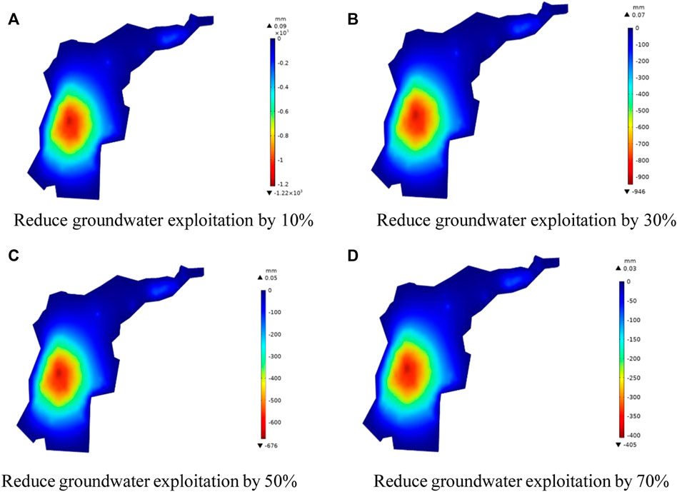
FIGURE 16. Development trends of land subsidence under different groundwater reduction plans in 2040. (A) Reduce groundwater exploitation by 10% (B) Reduce groundwater exploitation by 30%. (C) Reduce groundwater exploitation by 50% (D) Reduce groundwater exploitation by 70%.
It can be seen that with the decrease of groundwater extraction, although the location of the land subsidence funnel is not changed, its development trend will be obviously curbed, especially the land subsidence phenomenon at the center of the land subsidence funnel is significantly slowed down. The maximum cumulative land subsidence in Guangrao County in 2040 is extracted, and the values under the condition of 10%, 30%, 50% and 70% reduction are 1,220 mm, 946 mm, 676 mm and 405 mm respectively. Compared with the maximum cumulative land subsidence under the current groundwater mining condition (1,350 mm), The declines reached 7.63%, 26.93%, 52.93% and 78.00% respectively. The results show that reducing groundwater extraction is one of the simplest and most effective measures to prevent land subsidence.
According to the planning scheme of Dongying Municipal government for partial groundwater exploitation in Guangrao County and the current exploitation amount of each pumping well in the study area, the two areas with the most serious land subsidence in the study area are selected as the no-pumping areas (A and B) in this study, and the requirement that all pumping Wells in the area be shut down is strictly followed. The restricted mining area is shown in Figure 17.
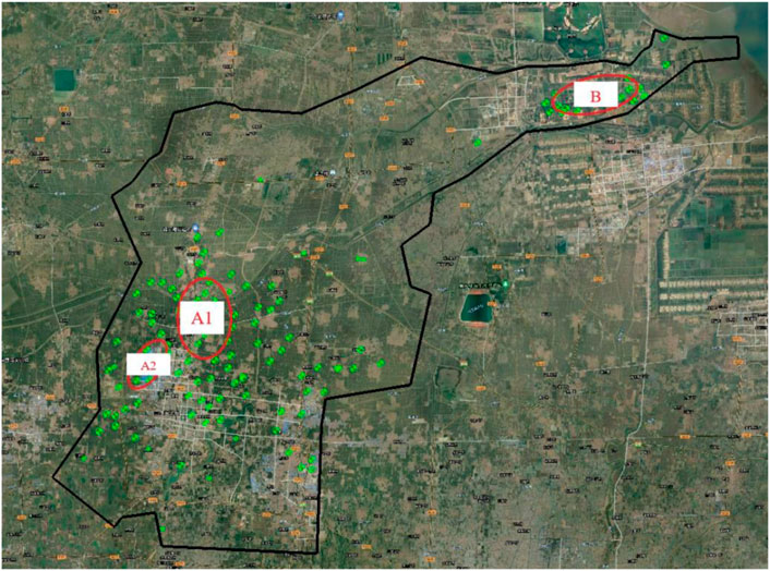
FIGURE 17. Sketch chart of demarcation of prohibited pumping area.
The fluid-solid coupling model was used to simulate the land subsidence in Guangrao area, and the land subsidence distribution chart (Figure 18) in 2040 when the mining prohibition measures were adopted was calculated, and the influence of the groundwater extraction prohibition on the land subsidence in the study area was analyzed.
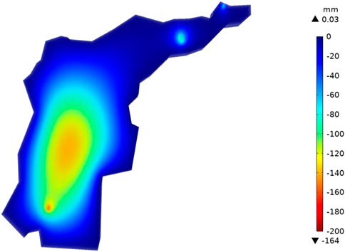
FIGURE 18. Forecast chart of land subsidence in Guangrao County in 2040.
It can be seen that the subsidence trend will change greatly after effective mining prohibition in the main subsidence area. In addition, the maximum land subsidence in the study area in 2040 under the mining prohibition condition is also reduced compared with the current mining condition, from 1,350 mm to 164.00 mm. Moreover, it can be seen that if the mining prohibition measures are implemented in a certain area, not only the land subsidence trend of the area will be slowed down, but also the land subsidence trend of the nearby area will be slowed down. It shows that it is feasible and effective to adopt a scientific mining prohibition scheme for the area with serious land subsidence.
In view of the development characteristics, current situation and development trend of land subsidence in Guangrao County, effective prevention and control of land subsidence in Guangrao County must be carried out. In order to better control the land subsidence within an acceptable range, it is necessary to carry out the prevention and control of land subsidence from the perspective of the whole region. Therefore, it is necessary to divide the prevention and control areas of land subsidence.
It is divided according to the characteristics, current situation and development trend of land subsidence, and the following principles are followed: the objectivity of land subsidence, the difference of land subsidence prevention and control, and the consistency between the prevention and control scope and the prevention and control subject. Taking into account in a comprehensive way the development status, evolution characteristics, cause analysis of land subsidence and the dynamic characteristics of shallow and deep groundwater, the whole area is divided into three areas: Key prevention and control area, Secondary key prevention and control area and General prevention and control area (Figure 19). Based on the analysis and research of land subsidence monitoring results, groundwater dynamic monitoring data and numerical simulation prediction results, and referring to the «Technical code for land subsidence monitor and control», the prevention and control measures for each region are proposed, as shown in Table 4.
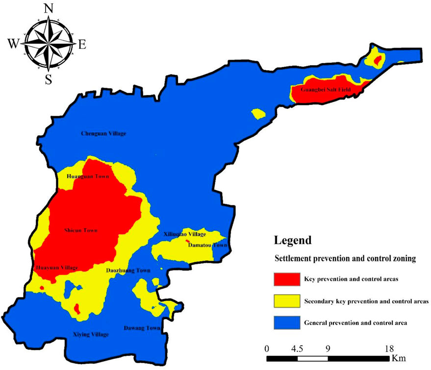
FIGURE 19. Zoning chart of land subsidence prevention and control in Guangrao County.
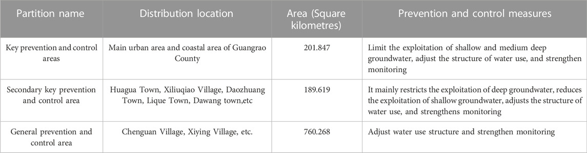
TABLE 4. Zoning table of land subsidence prevention and control in Guangrao County.
1) The numerical simulation calculation in this paper is based on the stratigraphic structure and physical and mechanical parameters in Guangrao area. It is assumed that the soil is continuously homogeneous and the aquifers are all one hydrogeological unit. The completely connected and boundary are continuous replenishment conditions with fixed head, which can form a stable groundwater flow. However, the actual groundwater storage environment and recharge conditions are complex, so it is difficult to have completely continuous aquifer or aquifer in practice, almost all of them are discontinuous and heterogeneous, and there is often hydraulic connection between aquifers. Therefore, there may be some deviation in the deformation and settlement characteristics of stratum in actual engineering.
2) The main purpose of this study is to analyze, restore and predict the regional characteristics and spatio-temporal evolution of land subsidence in the study area, and the accurate simulation of land deformation is not within the scope of this study. In order to improve the calculation efficiency, the porous elastic fluid-solid coupling calculation model does not consider the time effect of land subsidence lag caused by clay creep, etc., so the simulation results may have some errors, but it has no impact on the overall regional distribution characteristics and evolution trend prediction of land subsidence.
1) The land subsidence in Guangrao County has obvious regional characteristics, and gradually formed two subsidence funnels centered on the urban area and the Guangbei Salt Field. The average annual subsidence rate of the urban subsidence center is 131.5 mm/a, and the regional subsidence range includes the south of Huaguan Town, Shicun Town and Huayuan Town, which has a good spatial correlation with the deep groundwater descending funnel, which is mainly caused by excessive exploitation of deep groundwater in the fourth and fifth aquifers, The buried depth of the central water level of the funnel is 118–121 m. The average annual subsidence rate of the subsidence center of the Guangbei Salt Field is 102 mm/a, which has a good spatial correlation with the shallow groundwater descending funnel, which is mainly caused by excessive exploitation of the second and third aquifers, and the buried depth of the central water level of the funnel is 50–56 m.
2) A three-dimensional fluid-solid coupling numerical model of land subsidence in Guangrao County was established to restore the development process of land subsidence in Guangrao County from 2017 to 2020. It is predicted that under the current groundwater exploitation plan, the land subsidence in Guangrao County will continue to develop at a large rate in the next 20 years. By 2040, the land subsidence in Guangrao County will form a large regional subsidence funnel, and the maximum accumulated land subsidence in the urban area will reach 1,350 mm. Attention should be paid to the possible “passive subsidence” phenomenon in the connecting belt such as Lique Town, Dawang Town and Xiliuqiao Town.
3) This paper analyzes and predicts the evolution law of ground subsidence under the reduced and restricted groundwater exploitation schemes. Reducing or restricting groundwater exploitation can significantly slow down the development rate of ground subsidence. In order to curb the rapid development of ground subsidence, it is suggested to strictly control the exploitation of groundwater resources in the main urban area of Guangrao and around the Guangbei Salt Field, adjust the exploitation layout, and strengthen the introduction of foreign water resources. Xiliuqiao Town, Daozhuang Town, Lique Town, Guowang Village and other places can take control of mining, adjust the mining layout, strengthen the exploitation and utilization of shallow groundwater and other measures; The groundwater exploitation in Changuan Village, Xiying Village and other areas is basically in a balanced state.
The original contributions presented in the study are included in the article/Supplementary Material, further inquiries can be directed to the corresponding author.
PY: Conceptualization, Investigation, formal analysis, Writing—original draft; YD: Resources, Methodology, Writing—original draft; GW: Investigation, formal analysis, Writing—review and editing; BH: Investigation, Writing—review and editing; YY: Resources, Supervision. All authors have read and agreed to the published version of the manuscript.
The authors would like to show the gratitude to the financial supports from special financial projects of Shandong Province, Investigation, monitoring and prevention of land subsidence in Shandong Province (No. 370020210001-14).
The authors declare that the research was conducted in the absence of any commercial or financial relationships that could be construed as a potential conflict of interest.
All claims expressed in this article are solely those of the authors and do not necessarily represent those of their affiliated organizations, or those of the publisher, the editors and the reviewers. Any product that may be evaluated in this article, or claim that may be made by its manufacturer, is not guaranteed or endorsed by the publisher.
Abidin, H, Z., Andreas, H., Gumilar, I., Fukuda, Y., Pohan, Y, E., and Deguchi, T. (2011). Land subsidence of Jakarta (Indonesia) and its relation with urban development. Nat. Hazards (Dordr). 59 (3), 1753–1771. doi:10.1007/s11069-011-9866-9
Antonellini, M., Giambastiani, B, M, S., Greggio, N., Bonzi, L., Calabrese, L., Luciani, P., et al. (2019). Processes governing natural land subsidence in the shallow coastal aquifer of the Ravenna coast, Italy. Catena (Amst) 172, 76–86. doi:10.1016/j.catena.2018.08.019
Du, Z., Ge, L., Ng, H. M., Zhu, Q., and Yang, X. (2018). Correlating the subsidence pattern and land use in Bandung, Indonesia with both Sentinel-1/2 and ALOS-2 satellite images. Int. J. Appl. Earth Obs. Geoinf. 67, 54–68. doi:10.1016/j.jag.2018.01.001
Galloway, D. L., and Burbey, T. J. (2011). Review: Regional land subsidence accompanying groundwater extraction. Hydrogeol. J. 19 (8), 1459–1486. doi:10.1007/s10040-011-0775-5
He, Q. C., Liu, W. b., and Li, Z. M. (2006). Land subsidence survey and monitoring in the North China Plain. Geol. J. China Univ. 12 (2), 195–209. doi:10.3969/j.issn.1006-7493.2006.02.006
Hua, J.-X., and Zheng, J. G. (2017). Engineering geology manual. Fifth Edition. Xicheng, China: M. China Architecture & Building Press, 212–216.
Hussain, M. R., and Abed, B. S. (2019). Simulation and assessment of groundwater for domestic and irrigation uses. Civ. Eng. J. 5 (9), 1877–1892. doi:10.28991/cej-2019-03091379
Inaba, Y., Abe, I., Iwasaki, S., Aoki, S., Endo, T., and Kaido, R. (1970). Reviews of land subsidence researches in Tokyo.Land subsidence. Proc. Tokyo Symposium 1, 87–96.
Jeanne, P., Farr, T., Rutqvist, J., and Vasco, D. (2019). Role of agricultural activity on land subsidence in the san Joaquin valley, California. J. Hydrology 569, 462–469. doi:10.1016/j.jhydrol.2018.11.077
Ji, H. L., Yang, Y. B., Zhang, Y. W., Liu, S. Z., and Zhu, Z. Y. (2019). Quaternary sedimentary characteristics and land subsidence model in North Shandong Plain. Acta Geol. Sin. 93 (1), 241–250.
Jia, C., Zhang, G. R., Wang, J. B., and Zhang, Y. W. (2015). Study on land subsidence induced by groundwater extraction and its engineering application:taking Dezhou area of Shandong as an example. J. Earth Sci. Rnvironment 37 (04), 102–110. doi:10.3969/j.issn.1672-6561.2015.04.015
Jia, S. M., Tian, F., and Qi, G. (2019). Urban "chronic disease" - causes of land subsidence and comprehensive prevention and Control Countermeasures. Prev. control Geol. disaster 25 (1), 22–27.
Li, Q, F., and Wang, H. M. (2006). A study on land subsidence in Shanghai. Geol. J. China Univ. 12 (02), 169–178. doi:10.3969/j.issn.1006-7493.2006.02.003
Li, W. P., Wang, L. F., Guo, H. P., Wang, H. G., Wang, Y. L., Zhu, J. Y., et al. (2021). Effectiveness and countermeasures of land subsidence control in China. China Water Resour. 7, 32–35. doi:10.3969/j.issn.1000-1123.2021.07.015
Liu, Y. (2001). New progress and problems in land subsidence research. Earth Sci. Front. 2001 (2), 273–278. doi:10.3321/j.issn:1005-2321.2001.02.009
Liu, Y., Huang, H. J., and Li, P. Y. (2014). Characteristics of land subsidence caused by deep groundwater funnel in the Yellow River Delta. J. Basic Sci. Eng. 22 (05), 896–908. doi:10.1007/s11069-013-0648-4
Luo, Y., Ye, S. J., Wu, J. C., Zhang, Y. H., Jiao, X., and Wang, H. M. (2018). Global sensitivity analysis of parameters in land subsidence model. J. Zhejiang Univ. Eng. Sci. 52 (10), 2007–2013. doi:10.3785/j.issn.1008-973X.2018.10.021
Ora, B., Ag, C., Tb, D., Keesstra, S., Mohammadi, F., and Daliakopoulos, I. N. (2019). Land subsidence hazard modeling: Machine learning to identify predictors and the role of human activities. J. Environ. Manag. 236, 466–480. doi:10.1016/j.jenvman.2019.02.020
Ortega-Guerrero, A., Rudolph, D, L., and Cherry, J, A. (1999). Analysis of long-term land subsidence near Mexico City;field investigations and predictive modeling. Water Resour. Res. 35 (11), 3327–3341. doi:10.1029/1999wr900148
Othman, A., and Abotalib, A, Z. (2019). Land subsidence triggered by groundwater withdrawal under hyper-arid conditions:case study from Central Saudi Arabia. Environ. Earth Sci. 78 (7), 243–248. doi:10.1007/s12665-019-8254-8
Phien-Wej, N., Giao, P, H., and Nutalaya, P. (2006). Land subsidence in Bangkok, Thailand. Eng. Geol. 82 (4), 187–201. doi:10.1016/j.enggeo.2005.10.004
Qin, T. C., Cheng, G. M., and Wang, H. G. (2018). The latest progress of research on land subsidence abroad and its inspiration to China. Geo Log. Bull. China 37 (2/3), 503–509. doi:10.3969/j.issn.1671-2552.2018.02.028
Sarah, D., Soebowo, E., and Satriyo, N. A. Review of the land subsidence hazard in pekalongan delta.central java: Insights from the subsurface. Sch. J. 36 (4), 163–176. doi:10.17794/rgn.2021.4.13
Shrestha, P, K., Shakya, N, M., Pandey, V, P., Bikinshaw, S, J., and Shrestha, S. (2017). Model-based estimation of land subsidence in Kathmandu Valley, Nepal. Geomatics, Nat. Hazards Risk 8 (2), 974–996. doi:10.1080/19475705.2017.1289985
Tolma, C. F., and Poland, J. F. (1940). Ground-water,salt-water infiltration, and ground-surface recession in Santa Clara Valley,Santa Clara county, California. California, CA, USA: American Geophysical Union. doi:10.1029/Tr021i001p00023
Wang, Q. Y., Peng, J. B., Jiang, Z. W., and Teng, H. Q. (2014). Numerical simulation and layerwise mark monitoring of land subsidence and ground fissures of typical section in Xi’an. Rock Soil Mech. 35 (11), 3298–3302.
Xue, Y. Q., Zhang, Y., Ye, S. J., and Li, Q. F. (2003). Land subsidence in China and several problems to be solved. Quat. Res. 2003 (06), 585–593. doi:10.3321/j.issn:1001-7410.2003.06.001
Xue, Y. Q., Zhang, Y., Ye, S. J., Wu, J. C., Wei, Z. X., Li, Q. F., et al. (2006). Study on some problems of land subsidence in China. Geol. J. Coll. Univ. 12 (02), 153–160. doi:10.3969/j.issn.1006-7493.2006.02.001
Xue, T. X., Shen, C. Y., and Chen, R. Z. (2021). Monitoring methods and control measures of land subsidence. Constr. Des. Proj. 11 (2), 20–22. doi:10.13616/j.cnki.gcjsysj.2021.11.206
Yang, J. S. (2014). Research progress of land subsidence prevention and control in Shandong Province and analysis of land subsidence law in typical areas. China Popul. Resour. Environ. 24 (S3), 194–198.
Zhang, A., and Wei, Z, X. (2002). Past, present and future research on land subsidence in Shanghai City. Hydrogeology&Engineering Geol. 2002 (05), 72–75. doi:10.3969/j.issn.1000-3665.2002.05.023
Zhang, Y. W. (2014). Formation mechanism,monitoring and warning,controlling research of subsidence of Dezhou in North China Plain. Ph.D thesis (Jinan: Shandong University). doi:10.7666/d.Y2595854
Keywords: land subsidence, groundwater overexploitation, three-dimensional, fluid-solid coupling numerical model, evolution trend
Citation: Yang P, Dong Y, Zhang Y, Wu G and Yao Y (2023) Research on prevention and control methods of land subsidence induced by groundwater overexploitation based on three-dimensional fluid solid coupling model—a case study of Guangrao County. Front. Earth Sci. 10:1010134. doi: 10.3389/feart.2022.1010134
Received: 02 August 2022; Accepted: 29 November 2022;
Published: 17 January 2023.
Edited by:
Guang-Liang Feng, Institute of Rock and Soil Mechanics (CAS), ChinaReviewed by:
Qiu Enxi, Southwest Petroleum University, ChinaCopyright © 2023 Yang, Dong, Zhang, Wu and Yao. This is an open-access article distributed under the terms of the Creative Commons Attribution License (CC BY). The use, distribution or reproduction in other forums is permitted, provided the original author(s) and the copyright owner(s) are credited and that the original publication in this journal is cited, in accordance with accepted academic practice. No use, distribution or reproduction is permitted which does not comply with these terms.
*Correspondence: Yulong Dong, c3R4ZmR5bDExMjJAeWVhaC5uZXQ=
Disclaimer: All claims expressed in this article are solely those of the authors and do not necessarily represent those of their affiliated organizations, or those of the publisher, the editors and the reviewers. Any product that may be evaluated in this article or claim that may be made by its manufacturer is not guaranteed or endorsed by the publisher.
Research integrity at Frontiers
Learn more about the work of our research integrity team to safeguard the quality of each article we publish.