 Yan Lyu1,2
 Zuopeng Wang
- 1College of Geological Engineering and Geomatics, Chang’an University, Xi’an, China
- 2Key Laboratory of Western China Mineral Resources and Geological Engineering, Xi’an, China
The Yellow River Jingtai Stone Forest (YJSF) is situated in the northwestern margin of the Chinese Loess Plateau, and it is not only one of the most precious and rare types of natural landforms in the Loess Plateau but also a protected area of valuable geological relics and landscapes in northwest China. Massive rock structural planes are present in the stone forest. However, few studies have been conducted on the rock mass structural planes for the slope’s stability. Based on the detailed field investigation, structural planes and their combination types are classified based on the rock mass. On this basis, combined with physical, mechanical, and hydraulic tests, the disaster-induced mechanism of the rock mass structural planes is classified and discussed. Results show that the structural planes of the YJSF can be divided into three types, namely, the primary structural plane, tectonic structural plane, and secondary plane. They not only combine with each other to cut the rock mass into different shape blocks but also jointly control the stability of the rock mass slope. The physical and mechanical tests and water sensitivity characteristics show that the conglomerates and muddy sandstones which are the main components of the YJSF have strong tensile and shear strengths under natural situations, while their strengths are reduced under immersion infiltration; in particular, the muddy sandstones are more sensitive to water and have a lower strength than that of the conglomerates. Finally, the disaster-induced mechanism of the YJSF is mainly related to the combination of various structural planes, which can be divided into four failure patterns, namely, creeping slide-tension failure, gradual failure, slipping failure, and dumping failure; coupling action of endogenic and exogenic geodynamic processes was responsible for their formation. The studied results will provide critical, theoretical, and technical support for the slope stability analysis, scenic geological heritage protection, and disaster warning in this area.
Introduction
Chinese Loess Plateau is located in an arid–semiarid region, which is the largest loess accumulation region in the world (An, 2000; Nie et al., 2015; Peng et al., 2019). The YJSF, situated in the northwestern margin of the Loess Plateau, is characterized by different scale peak forest plains and peak cluster depressions. It is not only one of the most precious and rare types of natural landforms in the Loess Plateau but also a protected area of valuable geological relics and landscapes in northwest China, thus attracting thousands of tourists every year.
Due to the extensive development of valleys and complex topography in the YJSF area, geological hazards such as collapses, landslides, and debris flows occur usually, especially in spring and summer. These hazards, on the one hand, lead to a huge threat to the safety of tourists and tourist facilities, and on the other hand, they also pose new challenges to the protection of geological relics and landscape resources. The reason is that the formation of these disasters is not only related to the nature of rock masses and natural conditions in the area but also closely associated with a series of structural planes developed in the rock masses, which control the evolution of the stone forest valleys and the stability of the slope rock masses. However, massive research works on the YJSF have been conducted, but mainly focused on the description of aesthetics and landscape evolution processes (Xu and Fan, 2008; Fan, 2014). Fan (2006) and Zhang (2010) concluded that the formation of the stone forest was related to lithologies, tectonic movements, geomorphology, and weak layers in the rock masses; based on the flowing water, joints, and seasonal winds in this area, Zhang (2014) and Xu and Fan (2008) divided the YJSF landscapes into three major geological relics, consisting of geological structures, geomorphic, and geo-hazard types. These achievements have played an important role in further research of the stone forest. However, it is worth noting that few studies have been conducted on the rock mass structural planes of the stone forest, lacking profound analysis for the slope stability.
A series of observations and research studies have been conducted worldwide on the influences of rock mass structure planes for the slope stability (Lv et al., 2014; Stead and Wolter, 2015). Müller et al. (1970) realized the importance of structure planes to the mechanical characteristics and stability of rock masses; Gu and Wang (1979) put forward the control theory of rock mass structures, clarifying that the existence of rock mass structural planes has an important control effect on the deformation and failure of rock masses. Moreover, the occurrence, scale, density, shape, and combination types of structural planes are the main criteria for analyzing and evaluating the slope stability (Vick et al., 2020).
Hence, based on the detailed field investigation we conducted, this article classifies structural planes and their combination types contained in rock masses of the YJSF, northwestern Loess Plateau, China, in detail. On this basis, combined with physical, mechanical, and hydraulic properties of the rock masses, disaster-induced patterns and mechanisms of the rock mass structural planes are classified and discussed, to shed light on the importance of the structure planes for the slope stability in the YJSF area. The studied results will provide the critical, theoretical, and technical support for the slope stability analysis, scenic geological heritage protection, and disaster warning in this area.
Background of the Stone Forest
Geological Characteristics
The Tibetan Plateau and the Loess Plateau are one of the most important landform units in China, attracting a lot of researchers worldwide (Ding et al., 2014; Peng et al., 2019). The YJSF is located in the transition zone between the Loess Plateau and the Tibetan Plateau (Figure 1A). Due to the extensive uplifting of the Tibetan Plateau during the Cenozoic period, the transition zone and its surrounding areas are characterized by a series of active faults (Yao et al., 2019), especially the Haiyuan active fault which induced massive earthquakes (Tian et al., 2002; Li et al., 2019; Shi et al., 2020; Xu et al., 2021). The studied area is situated at the Laolongwan Depression on the western part of the Haiyuan fault zone (Figure 1B). Research confirmed that the Laolongwan Depression is a small Quaternary rift basin controlled by three groups of faults in the NWW, NEE, and NNE directions (Fan, 2014), with the basin’s subsidence range exceeding 200 m. Uplifting fault blocks around the depression periphery were developed, including the Mijia-Hasi Mountain to the north, Songjia Mountain to the south, Hongxiantai to the west, and Liupan Mountain to the east.
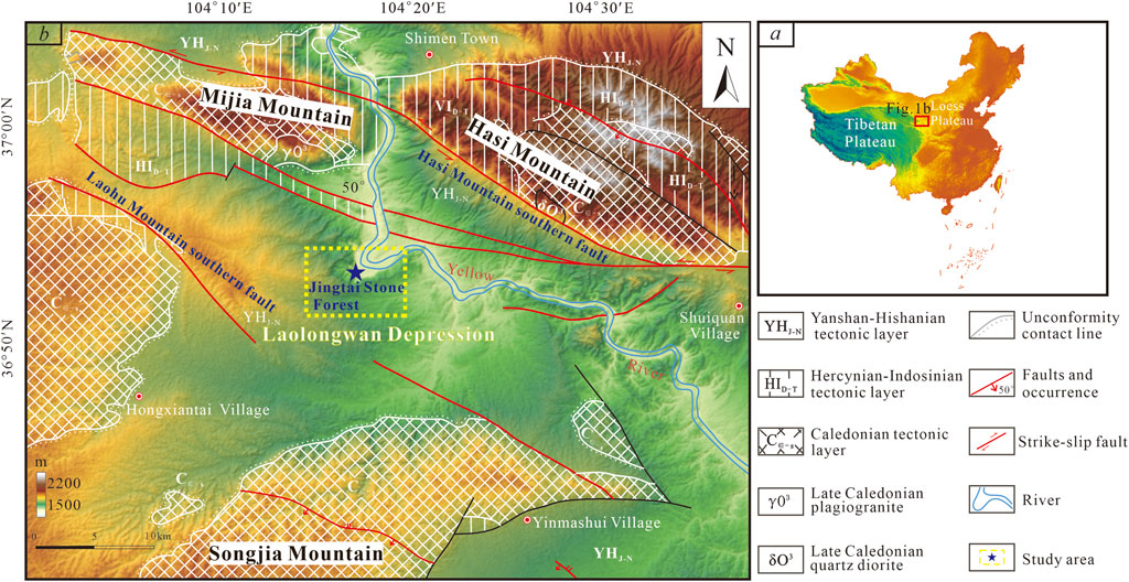
FIGURE 1. (A) Location of the study area in China. (B) Geological map of the study area [modified from Tian et al. (2000) and Fan (2014)].
The strata in the Laolongwan Depression are mainly composed of Cenozoic sedimentary rocks (Fan, 2006; Fan, 2014), which are dominated by Quaternary fluvial and lacustrine facies with a thickness of up to hundreds of meters (Figure 2). According to the degree of rock consolidation, these sedimentary rocks can be divided into upper and lower parts. Among them, the lower part is the Early Pleistocene Wuquanshan Formation with a good degree of consolidation. This formation consists of upper and lower sections, of which the lower rocks are composed of gray–yellow conglomerates with high argillaceous contents and muddy sandstones, while the upper rocks resemble the former, but have lower argillaceous contents. The upper part mainly consists of floodplain facies sandstones and conglomerates, as well as a small amount of aeolian loess. The modern Yellow River flows through the depression basin from west to east, dividing the Cenozoic sedimentary formation into east and west blocks, and the YJSF is developed at the turn of the Yellow River in the western block (Figure 1B).
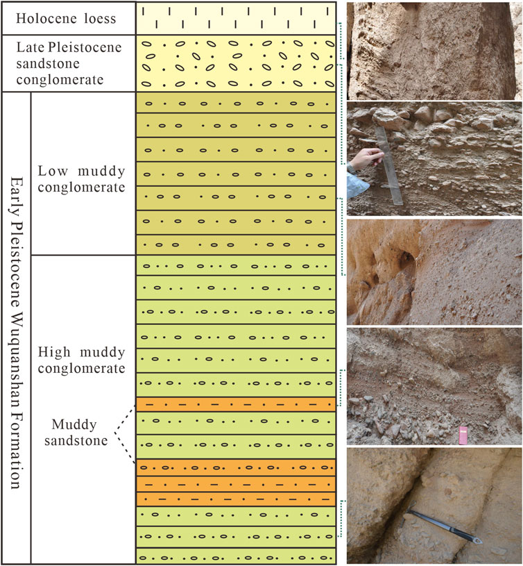
FIGURE 2. Strata histogram and corresponding lithological photos of the YJSF. The lower part is the Early Pleistocene Wuquanshan Formation consisting of upper and lower sections, with different consolidation degrees. The upper part mainly consists of floodplain facies sandstones and conglomerates, as well as a small amount of aeolian loess.
Topography and Geomorphology Characteristics
The terrain of the YJSF is generally high in the southwest and northeast, with low terrain in the middle. The highest elevation is 3,010 m, and the lowest is 1,390 m with an average of 2000 m. According to the classification characteristics of geomorphology, the stone forest displays the typical features of peak-forest plains and peak clusters (Figure 3). The top of a single peak shows a conical and flat shape, with obvious differences in height between the peaks. Bases between the peaks were connected to each other, showing two morphologies of “U” and “V” types. Moreover, there are multilevel active fault-related steeps developed in the upper reaches of the valley, and aeolian landforms such as wind-eroded dimples and wind-eroded niches can be seen on both sides of the ditch wall.
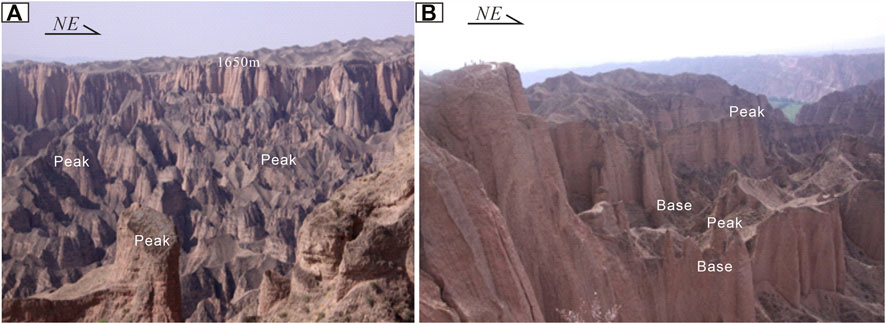
FIGURE 3. Typical features of peak forest plains and peak clusters in the study area.
Climate and Hydrological Characteristics
The studied area is a typical temperate continental arid climate with scarce precipitation. The precipitation in this area is mainly concentrated in the range of July to September and shows a gradual decrease trend from south to north. Its maximum precipitation in a day can reach 57.1 mm, of which the frequency of heavy rains is 1–2 times/year (Fan, 2014). Additionally, precipitation in a wet year is 2–3 times that of a dry year, showing apparent interannual variation traits. Obviously, drought and low rainfall are the major characteristics of climate and hydrology in this area, which played an important role in the formation and evolution of the YJSF and its slope stability.
Collectively, it can be concluded that the formation of the YJSF was closely related to tectonic activities, rock types, topography, and geomorphology, as well as climate and hydrological conditions.
Types and Characteristics of Rock-Mass Structural Planes
The types and characteristics of structural planes in rock masses are very important to the slope stability (Gori et al., 2014; Vick et al., 2020). They can result in discontinuity and non-uniformity of the rock masses. The structural planes of the YJSF can be divided into primary, tectonic, and secondary structural planes, according to their geological genesis, and they jointly control the stability of the slope in this area, as described below.
Primary Structural Planes
Primary structural planes in the YJSF are composed of layers and weak interlayers (Figures 4A–C). The sedimentary layers are the most widely distributed structural planes in the rock mass of the stone forest, mainly developed during the Quaternary Wuquanshan Formation with extensive outcropping in this area (accounting for 70% in the Laolongwan Depression). The strata tilt toward southwest as a whole, and their dip angles vary between 10° and 30°. Their surfaces are relatively flat and well extended, with the intervals of these layers varying from 0.2 to 1 m. The weak interlayers consist of silty mudstones, claystones, and highly muddy sandstones, with a poor consolidation degree and high clay content, and the thickness ranges from 5 to 10 cm. Compared with the layers, the weak interlayers in rock masses have a significant impact on the stability of the YJSF slope, due to their poorer mechanical properties and easy softening or muddying in contact with water (Peng et al., 2015).
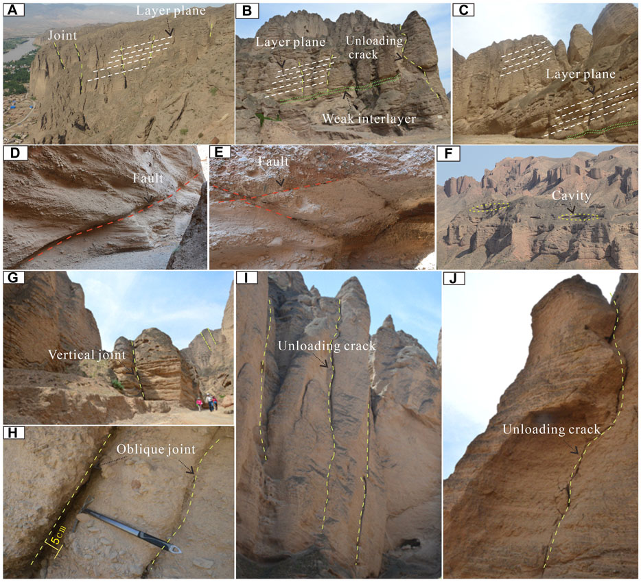
FIGURE 4. Structural plane types and combination characteristics of typical rock slopes in the study area. (A) Layer plane and joint; (B,C) layer plane, joint, and weak interlayer; (D,E) fault; (F) cavity; (G,H) vertical and oblique joints; and (I,J) unloading fracture.
The primary structural planes are a weak structural zone, and thus many cavities such as wind-eroded dens and niches were formed under the action of wind erosion, abrasion, and erosion of rainwater around these planes, which is a common phenomenon in the YJSF area. Moreover, they resulted in the occurrence of a free surface in the rock slope, which is one of the important factors causing the slope instability in the YJSF.
Tectonic Structural Planes
Tectonic structural planes are a fractured plane in rock and soil caused by tectonic stress, including faults, joints, cleavages, and interlayer dislocation planes (Arai and Chigira, 2019; Shao et al., 2019; Blahüt et al., 2020). The tectonic structural planes of the YJSF mainly consist of faults and joints (Figures 4D–H, 5). These faults are dominated by active faults in the NW and NE directions, extending 2–10 km with a 5- to 30-cm-wide fracture zone developed along the faults. Moreover, the fracture zone is well open and filled with sand and gravel, of which some have been muddied into weak interlayers. A group of X-shaped faults can be seen in the Laolonggou area, the southwestern part of the stone forest, indicating that the direction of regional tectonic principal stress is dominated by the NE–SW directions. These faults controlled the flow direction of the Yellow River and the development of valley’s water systems, making the river and its tributaries typical grid-like and comb-like frameworks. Meanwhile, they cut the sedimentary strata into different shape blocks, and the opening degree of the fracture near the slope of the valley is much larger than that of other sections. The development characteristics of these faults provide a prerequisite for the formation of the YJSF.
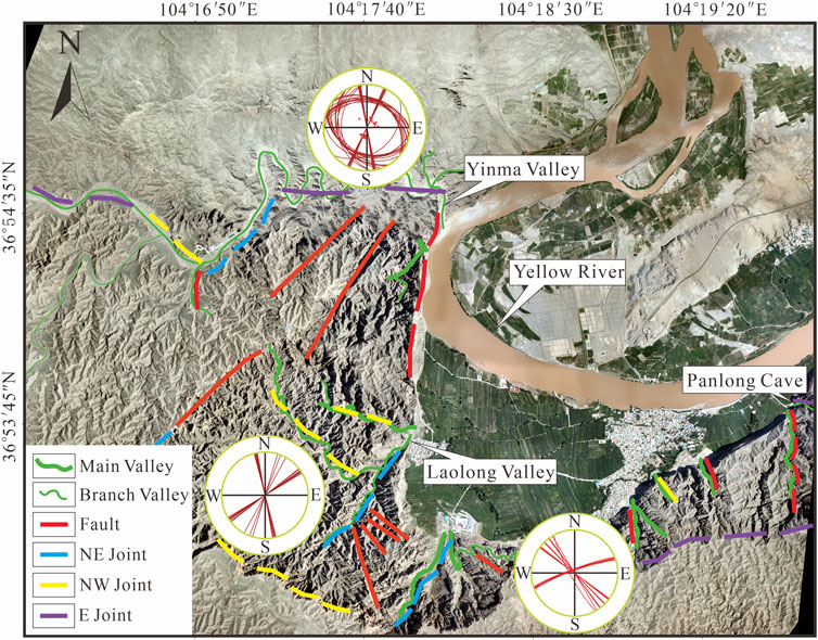
FIGURE 5. Distribution of faults and joints in the study area. Strikes of faults and joints are dominated by the NWW and NE directions.
Except for the faults, joints are also one of the most widely developed structural planes in the studied area, which are mainly distributed in the three regions including the Laolong Valley, Yinma Valley, and Panlong Cave (Figure 5). The Laolong Valley is dominated by vertical joints, and their directions are roughly 340°–350°and 65°–70°, with the joint spacing of 3–18 m. Field investigation shows that they were used as the dominant infiltration channel, and some gullies with a width of 50–100 cm have been formed during the erosion of flowing water, where a series of huge sandy gravel blocks were found within the gullies. There are two types of vertical and oblique joints developed in the Yinma Valley. The vertical joint directions display 10° and 345° trends, and the oblique joint dips are NNE and SW, respectively, with a dip angle of 20°–30°. The joint spacings range from 2 to 3 m, and their open distances are 5–10 cm. The Panlong Cave joints are relatively simple, and a group of near-vertical tensile joints are developed in the NWW direction. The dip and dip angle are 340° and 80°, respectively, which is nearly parallel to the strike of the Panlong Cave. The average distance between joints is about 9 m. The open gap of joints near the stone forest valley is 50–80 cm, while others are 8–10 cm away from the valley. Massive breccia having weak consolidation is filled with these joint gaps.
Secondary Structural Planes
Secondary structural planes in the YJSF are mainly composed of unloading cracks and secondary intercalated muddy rocks (Figures 4I, J), but they are all locally distributed. Unloading cracks were majorly generated at the edge of the slope, characterized by a discontinuous distribution and rough fissure surface. Secondary intercalated muddy rocks were generally filled within the unloading cracks, further leading to the large gaps between fissure surfaces. The formation of secondary structural planes in this area was closely correlated with the gravitational forcing and weathering, coupled with rainfall infiltration.
In summary, the studied primary structural planes were related to the formation of sedimentary rocks, the tectonic structural planes mainly resulted from tectonic activities, and the secondary structural planes were correlated with gravity, water, and wind.
Physical and Mechanical Properties and Water sensitivity
The YJSF is dominantly composed of conglomerates and muddy sandstones. We sampled 30 representative samples in the Laolong Valley, Yinma Valley, and Panlong Cave areas, to analyze the physical and mechanical properties of these rocks under the conditions of natural situation and immersion infiltration, as well as hydraulic properties. Tensile (splitting method), shear (inclination compression mold), and grain-size analysis tests were designed for the conglomerates and muddy sandstones. In addition, as muddy sandstones have obvious softening and disintegration characteristics after encountering water, a fast shear test for the rock was designed.
Grain-Size Analysis
The grain-size analysis results showed that the conglomerates are characterized by uneven grain-size distribution and continuous particle gradation, and on the contrary, the muddy sandstones have the features of uniform grain-size distribution and discontinuous particle gradation (Figure 6). The range diagrams of grain-size content display that both the conglomerates and the muddy sandstones have single-peak curve features; the particles that were cemented into conglomerates are mainly medium-fine gravels, with a small amount of medium-sized sand; and the muddy sandstones are dominated by fine-sized sand and less clay contents, which is one of the critical reasons for the weak cementation of the YJSF.
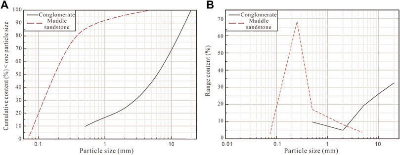
FIGURE 6. Grain size curves of the conglomerate (A) and muddy sandstone (B). The conglomerate is characterized by uneven grain size distribution and continuous particle gradation, and on the contrary, the muddy sandstone has the features of uniform grain size distribution and discontinuous particle gradation.
Tensile and Shear Strength Analyses
The test results showed that the tensile and shear strengths of conglomerates were only 60–70% of those of muddy sandstones under natural situation (Table 1), indicating the degree of conglomerate cementation is lower than that of muddy sandstones. However, under the condition of immersion infiltration, the tensile and shear strengths of the conglomerates and muddy sandstones decreased sharply, which is only 5–10% of those of the natural situation, and their shear strengths were much greater than the tensile strength. Meanwhile, under immersion infiltration, the shear strength of conglomerates was greater than that of muddy sandstones.
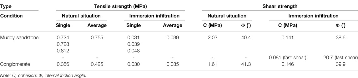
TABLE 1. Test results on the muddy sandstone and conglomerate in the stone forest.
During the fast shear test, the cohesion and internal friction angle of muddy sandstones under immersion infiltration were 81 kPa and 20.7° (Table 1), respectively, which were smaller than the shear strength under the condition of inclination compression mold. Besides, in the direct shear process, when the deformation reached 0.2 mm, the muddy sandstones had a peak strength of 88–192 kPa which increased with increase in the confining pressure (Figure 7), and the residual strength differed from it by 5–10%. This result shows that the muddy sandstones in the YJSF are characterized by strain softening.
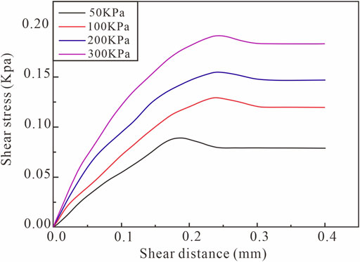
FIGURE 7. Stress–strain curves of the muddy sandstone under the immersion infiltration (fast shear test).
Thus, under the condition of natural situation, both the conglomerates and muddy sandstones in the YJSF have strong tensile and shear strengths, while under immersion infiltration, the collapsibility of muddy sandstones is more obvious, which usually leads to the lack of rock mass and induces slope instability in this area.
Water Sensitivity Analysis
As aforementioned, the physical property tests show that the conglomerates and muddy sandstones in this area have obvious water sensitivity features. Therefore, in order to explore the causes of water sensitivity, a microscopic identification and composition analysis were carried out on two rocks.
The results showed that the conglomerates and muddy sandstones are composed of debris, interstitials, and storage spaces (Figure 8). Among them, the debris that was dominated by quartz and feldspar was the main component of the two rocks accounting for 50–60%; the interstitials were mainly muddy fillings, and obviously appear in muddy sandstones and conglomerates; and the storage spaces were all secondary pores, mainly including water-soluble pores and structural fractures.
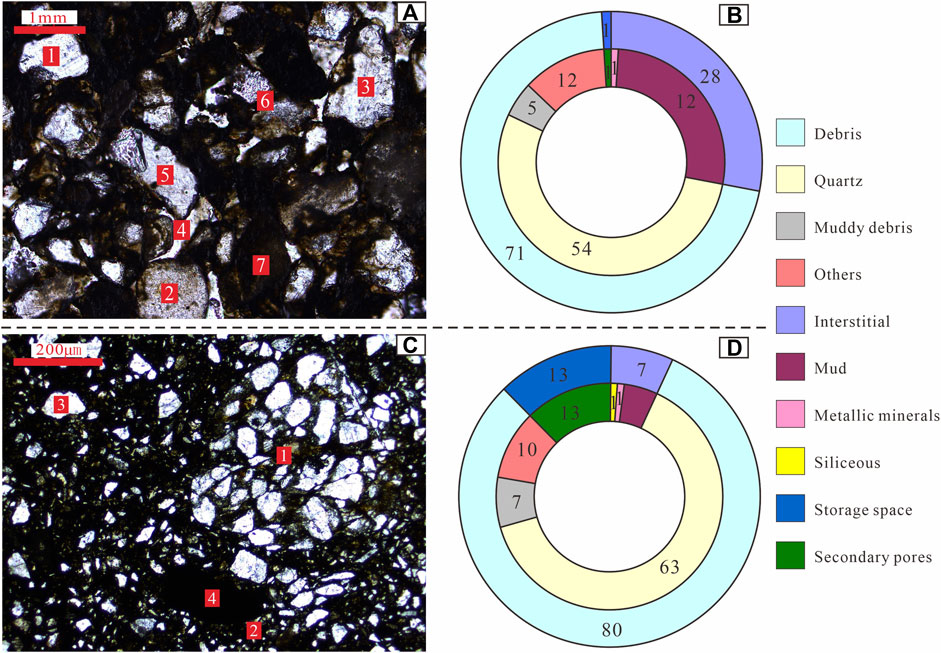
FIGURE 8. Microscopic characteristics and composition proportion of the conglomerate (A,B) and muddy sandstone (C,D). (A) 1–6: quart and feldspar debris; 7: muddy fillings; (C) 1–3: quart and feldspar debris; and 4: muddy fillings.
It was found that the muddy fillings consist of water-sensitive minerals, such as kaolin, hydromica, and illite. When these minerals meet with water, the particles will swell (Leng et al., 2021), making the rock structure to easily collapse. Moreover, muddy components in the rock masses may be taken away by water, forming water-soluble pores and further enhancing the possibility of structural disintegration. Additionally, the muddy fillings also display colloidal properties after encountering water, and have strong flow plasticity and water holding capacity. After continuous water erosion, clay minerals in the muddy sandstones are lost and their strengths are weakened, resulting in the occurrence of cavities in the rock masses. Therefore, the water sensitivity characteristics of the stone forest have a significant influence on the slope stability.
Structural Plane Combination and the Failure Mechanism
According to the aforementioned structural characteristics and their influence on slope stability, this article divides the types of structural planes related to the slope failure of the YJSF into four main types. 1) Combination of vertical joints and weak interlayers (Figures 4A,B). The strike of weak layers is consistent with that of the rock slope, and the vertical joints cut rock masses with a certain width to form quadrangular prism–shaped or inverted cone–shaped blocks. 2) Combination of vertical joints and oblique joints (Figures 4B,D,H). The dip direction of the oblique joints is consistent with that of the rock slope. They jointly cut the rock mass to form quadrangular prism–shaped or irregular blocks. 3) Combination of vertical joints, oblique joints, and weak interlayers (Figure 4B). The dip direction of the oblique joints is consistent with that of the weak interlayers. They jointly cut the rock mass to form irregular blocks. 4) Combination of unloading joints and layer planes (Figures 4I,J). The dip direction of the unloading joints is consistent with that of the layers, which jointly divide the rock mass into irregular blocks.
This combination of structural planes controls the slope stability of the YJSF, and the corresponding failure patterns and mechanism are as follows:
Creeping Slide-Tension Failure
Studies show that the differences in the degree of softness and hardness of the layered rock masses constituting the slope, as well as the location of the soft and hard layers, have an important impact on the slope stability (Insua-Arévalo et al., 2021; Wang et al., 2021). The stratum formation of the YJSF was characterized by relatively soft layers in the upper section and hard layers in the lower section; the upper part is mainly poorly consolidated floodplain facies and secondary aeolian loess, with low strength, while the lower was the Early Pleistocene Wuquanshan Formation with a long diagenesis time and good degree of consolidation which is hard and not easy to deform. Thus, the contact surface between the two layers was a structurally weak zone, similar to a weak interlayer. Under the long-term action of gravity, this kind of sedimentary construction combination tends to develop creeping deformations and failures of the overlying weak rocks along the structurally weak zone (Figure 9A). Additionally, based on the aforementioned physical mechanics and water sensitivity tests, the muddy sandstone strata contained in the conglomerates of the Wuquanshan Formation have relatively weak tensile and shear strengths, and especially under the condition of immersion in water, they are prone to disintegration. Therefore, it can also be found that the interlayers of muddy sandstones generated a non-uniform creep in the overlying stress and the action of water infiltration, causing the overlying relatively hard conglomerate to produce cracking characteristics at its bottom.
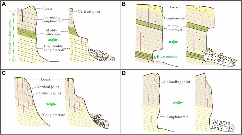
FIGURE 9. Schematic failure mechanism diagrams of the YJSF. (A) Creeping slide-tension failure, (B) gradual failure, (C) slipping failure, and (D) dumping failure.
Gradual Failure
Investigation results show that there are many cavities in the rock layers of the YJSF area, and their formation was mainly related to the muddy sandstones that were sandwiched between the upper and lower conglomerate layers. The mechanism forming these cavities mainly include two aspects: on the one hand, the local disintegration and shedding of particles such as quartz and feldspar occur under the action of wind blowing and abrasion; on the other hand, the muddy sandstones contain massive water-sensitive minerals (e.g., kaolin, illite, and montmorillonite), which swells under the action of high rainfall, leading to the destruction of a muddy sandstone structure. Moreover, under the combined action of the two kinds of external dynamic geology, a special phenomenon that underlying soft rocks were absent and upper hard rocks were suspended extensively appears in the rock wall of the YJSF. Specially, when the muddy sandstones were developed at the bottom of the stone forest, due to the continuous later erosion of the Yellow River, massive large cavities were generated in this area resulting in the occurrence of overlying dangerous rock masses that are predominantly composed of conglomerates. These suspended dangerous rock masses will be gradually collapsed and destroyed due to the gravitational forcing, earthquakes, and other actions (Figure 9B), of which the point of rupture initiation usually follows the preexisting structural planes within the overlying rock masses.
Slipping Failure
In the YJSF area, especially the Yinma Valley area, the rock masses were jointly cut by multiple sets of vertical joints and a set of oblique joints, forming different scale rock blocks. The vertical joints are gradually expanded downward under a series of factors, such as self-weight stress of rock mass, regional tectonic uplifting, and rainfall infiltration. When the vertical structural planes are not completely transfixed or supported by other rock masses, the rock masses remain stable. As the vertical joints gradually expand downward into the oblique joint planes, the rock masses could slide out along the inclined direction of the oblique joint in the lower part, thus forming a slipping failure feature (Figure 9C).
Dumping Failure
There are a series of unloading cracks developed in the rock slopes of the YJSF, which are curved in shape (Figures 4I,J). These cracks were filled with some sands, conglomerates, and loess, and their opening degrees gradually decrease from the top to the bottom. The formation was related to the self-weight stress and weathering unloading. Moreover, the water sensitivity experiments discussed above show that the muddy sandstones and conglomerates contain some argillaceous components, which will swell after encountering water, leading to the destruction of these rock structures and disintegration. During downward expansion of these unloading cracks, the center of gravity of the dangerous rock masses gradually moves outward, and finally, it could result in dumping failure (Figure 9D).
Discussion
Structural planes and their combinations have played an important role in the stability of rock-soil mass slopes (Gu and Wang, 1979; Lv et al., 2014). The stability of the YJSF is related to the coupling action of endogenic and exogenic geological processes. The endogenic dynamic geological processes mainly originated from the Cenozoic uplifting, fault activities, and earthquakes of the Tibet Plateau. During the uplifting process, the Cenozoic sediments in the Laolongwan Depression were affected by differential uplifting and compressional tectonics, resulting in the appearance of strata deformation and a series of tectonic structural planes. These processes could lead to the loosening of the rock mass and reduce their strength. In addition, the northeastern margin of the Tibet Plateau is an area of strong earthquakes, such as the 1920 Haiyuan earthquake (Tian et al., 2000; Tian et al., 2002; Yao et al., 2019; Xu et al., 2021). The process of earthquake has the effect of shattering rock mass, leading to the further development of rock mass structural planes in this basin and appearance of different combinations of structural planes as discussed above.
The studied area is located in a temperate continental climate zone (Fan, 2006), and thus the exogenic dynamic geological processes are dominated by rainfalls and winds. Annual rainfall contents in this area are relatively scarce, but heavy rainfall may occur many times (Zhang, 2010; Zhang, 2014). The rainwater infiltrates into the rock masses along the structural planes; on the one hand, it caused the valley erosion and formed a disaster-generating free surface, and on the other hand, the water in the structural planes can generate hydrodynamic and hydrostatic pressures (Peng et al., 2015), which all aggravate the instability of the YJSF slope. Meanwhile, the muddy sandstones in the area are characterized by strong water sensitivity, which is also one of the important factors causing the slope instability. Compared with the effect of rainfalls, the direct effect of winds is not obvious, but it can denude and blow away the surface-weathered materials for a long time, causing the rock masses to unload and rebound, and further aggravating the development of structural planes in the YJSF area.
Conclusion
Massive structural planes are developed in rock slopes of the YJSF area, northwestern Loess Plateau, China. This article, based on a detailed field investigation, classifies structural planes and their combination types contained in rock masses of the YJSF. On this basis, combined with physical, mechanical, and hydraulic properties of the rock masses, disaster-induced patterns and mechanisms of the rock mass of structural planes are classified and discussed. The main results gained are as follows:
1) The structural planes of the YJSF can be divided into three types, namely, primary structural plane, tectonic structural plane, and secondary plane. They not only combine with each other to cut the rock masses into different-shape blocks but also jointly control the stability of the rock mass slopes.
2) The physical and mechanical tests and water sensitivity characteristics show that the conglomerates and muddy sandstones which are the main components of the YJSF have greater tensile and shear strengths under natural situation, while their strengths are reduced under immersion infiltration; in particular, the muddy sandstones are more sensitive to water and have a lower strength than that of the conglomerates.
3) The failure mechanism of the YJSF is mainly related to the combination of various structural planes, which can be divided into four failure patterns, namely, creeping slide-tension failure, gradual failure, slipping failure, and dumping failure. This study will have a critical influence on the stability analysis of rock slopes and disaster warning in this area.
Data Availability Statement
The original contributions presented in the study are included in the article/Supplementary Material; further inquiries can be directed to the corresponding author.
Author Contributions
YLY performed field investigation, wrote the manuscript, and conducted analysis. GG performed field investigations and experiment. ZW performed field investigations, wrote the manuscript, and conducted analysis. YL performed field investigation and interpretation of data for the work. PM performed field investigation and conducted analysis. JP designed the work and conducted field investigations and writing.
Funding
This research was financially supported by the National Natural Science Foundation of China (Grant No. 41672285) and the Fundamental Research Funds for the Central Universities, CHD (Grant Nos. 300103190742, 300102271403, and 300102261403).
Conflict of Interest
The authors declare that the research was conducted in the absence of any commercial or financial relationships that could be construed as a potential conflict of interest.
Publisher’s Note
All claims expressed in this article are solely those of the authors and do not necessarily represent those of their affiliated organizations, or those of the publisher, the editors, and the reviewers. Any product that may be evaluated in this article, or claim that may be made by its manufacturer, is not guaranteed or endorsed by the publisher.
Acknowledgments
We gratefully appreciate editor YX and two reviewers for their constructive reviews and suggestions, which essentially improved the quality of this article.
References
An, Z. (2000). The History and Variability of the East Asian Paleomonsoon Climate. Quat. Sci. Rev. 19, 171–187. doi:10.1016/s0277-3791(99)00060-8
Arai, N., and Chigira, M. (2019). Distribution of Gravitational Slope Deformation and Deep-Seated Landslides Controlled by Thrust Faults in the Shimanto Accretionary Complex. Eng. Geology. 260, 105236. doi:10.1016/j.enggeo.2019.105236
Blahüt, J., Mitrovic-Woodell, I., Baroň, I., René, M., Rowberry, M., Blard, P. H., et al. (2020). Volcanic Edifice Slip Events Recorded on the Fault Plane of the San Andrés Landslide, El Hierro, Canary Islands. Tectonophysics 776, 228317. doi:10.1016/j.tecto.2019.228317
Ding, L., Xu, Q., Yue, Y., Wang, H., Cai, F., and Li, S. (2014). The Andean-type Gangdese Mountains: Paleoelevation Record from the Paleocene-Eocene Linzhou Basin. Earth Planet. Sci. Lett. 392, 250–264. doi:10.1016/j.epsl.2014.01.045
Fan, W. J. (2014). Study on the Sustainable Development of the Yellow River Stone Forest Geological Landscape in Gansu Province. Dissertation`s thesis. China, Beijing: China University of Geosciences.
Fan, X. (2006). “Landscape Characteristics and Genesis Mechanism of the Yellow River Stone Forest, Gansu Province,” in The 21st Annual Meeting of Tourism Geology and Geoparks Research Branch of Geological Society of China, Xi’an, China, 2006, 363–367. (in Chinese).
Gori, S., Falcucci, E., Dramis, F., Galadini, F., Galli, P., Giaccio, B., et al. (2014). Deep-seated Gravitational Slope Deformation, Large-Scale Rock Failure, and Active normal Faulting along Mt. Morrone (Sulmona basin, Central Italy): Geomorphological and Paleoseismological Analyses. Geomorphology 208, 88–101. doi:10.1016/j.geomorph.2013.11.017
Gu, D. Z., and Wang, S. J. (1979). “The Basic Problems of Engineering Geological Mechanics. Engineering Geology Professional Committee, Geological Society of China,” in Proceedings Of the 1st Chinese Geological Academic conference, Suzhou (China), 1979, 182–189.
Insua-Arévalo, J. M., Tsige, M., Sánchez-Roldán, J. L., Rodríguez-Escudero, E., and Martínez-Díaz, J. J. (2021). Influence of the Microstructure and Roughness of Weakness Planes on the Strength Anisotropy of a Foliated clay-rich Fault Gouge. Eng. Geology. 289, 106186. doi:10.1016/j.enggeo.2021.106186
Leng, Y. Q., Peng, J. B., Wang, S., and Lu, F. (2021). Development of Water Sensitivity index of Loess from its Mechanical Properties. Eng. Geology. 280, 105918. doi:10.1016/j.enggeo.2020.105918
Li, B., Chen, X., Zuza, A. v., Hu, D., Ding, W., Huang, P., et al. (2019). Cenozoic Cooling History of the North Qilian Shan, Northern Tibetan Plateau, and the Initiation of the Haiyuan Fault: Constraints from Apatite- and Zircon-Fission Track Thermochronology. Tectonophysics 751, 109–124. doi:10.1016/j.tecto.2018.12.005
Lv, Y., Peng, J., and Wang, G. (2014). Characteristics and Genetic Mechanism of the Cuihua Rock Avalanche Triggered by a Paleo-Earthquake in Northwest China. Eng. Geology. 182, 88–96. doi:10.1016/j.enggeo.2014.08.017
Müller, L., Malina, H., and Baudendestel, M. (1970). “The Effect of the Geologic Structure on the Stability of an Underground Powerhouse,” in 2nd congress Of I. S. R. M, Belgrade, 1970.
Nie, J., Stevens, T., Rittner, M., Stockli, D., Garzanti, E., Limonta, M., et al. (2015). Loess Plateau Storage of Northeastern Tibetan Plateau-Derived Yellow River Sediment. Nat. Commun. 6, 8511. doi:10.1038/ncomms9511
Peng, J., Fan, Z., Wu, D., Zhuang, J., Dai, F., Chen, W., et al. (2015). Heavy Rainfall Triggered Loess-Mudstone Landslide and Subsequent Debris Flow in Tianshui, China. Eng. Geology. 186, 79–90. doi:10.1016/j.enggeo.2014.08.015
Peng, J., Wang, S., Wang, Q., Zhuang, J., Huang, W., Zhu, X., et al. (2019). Distribution and Genetic Types of Loess Landslides in China. J. Asian Earth Sci. 170, 329–350. doi:10.1016/j.jseaes.2018.11.015
Shao, C., Li, Y., Lan, H., Li, P., Zhou, R., Ding, H., et al. (2019). The Role of Active Faults and Sliding Mechanism Analysis of the 2017 Maoxian Postseismic Landslide in Sichuan, China. Bull. Eng. Geol. Environ. 78, 5635–5651. doi:10.1007/s10064-019-01480-8
Shi, Y.-t., Gao, Y., Shen, X.-z., and Liu, K. H. (2020). Multiscale Spatial Distribution of Crustal Seismic Anisotropy beneath the Northeastern Margin of the Tibetan Plateau and Tectonic Implications of the Haiyuan Fault. Tectonophysics 774, 228274. doi:10.1016/j.tecto.2019.228274
Stead, D., and Wolter, A. (2015). A Critical Review of Rock Slope Failure Mechanisms: The Importance of Structural Geology. J. Struct. Geology. 74, 1–23. doi:10.1016/j.jsg.2015.02.002
Tian, Q. J., Ding, G. Y., and Shen, X. H. (2002). Seismic Tectonic Model of the Northeastern Corner of the Tibet Plateau. Earthquake 22, 9–16. (in Chinese).
Tian, Q. J., Shen, X. H., Ding, G. Y., Chen, Z. W., and Wei, K. H. (2000). Discovery and Preliminary Study of the Laolongwan Tertiary Pull-Apart basin in the Haiyuan Fault Zone. Seismology Geology. 22, 329–336 (in Chinese).
Vick, L. M., Böhme, M., Rouyet, L., Bergh, S. G., Corner, G. D., and Lauknes, T. R. (2020). Structurally Controlled Rock Slope Deformation in Northern Norway. Landslides 17, 1745–1776. doi:10.1007/s10346-020-01421-7
Wang, J., Chen, G., Xiao, Y., Li, S., Chen, Y., and Qiao, Z. (2021). Effect of Structural Planes on Rockburst Distribution: Case Study of a Deep Tunnel in Southwest China. Eng. Geology. 292, 106250. doi:10.1016/j.enggeo.2021.106250
Xu, K. J., and Fan, X. (2008). Characteristics and Evaluations of Geological Trace Landscapes of Yellow River Hoodoo Nation Geopark. J. Arid Land Resour. Environ. 22, 111–115. (in Chinese).
Xu, Y., Liu-Zeng, J., Allen, M. B., Zhang, W., and Du, P. (2021). Landslides of the 1920 Haiyuan Earthquake, Northern China. Landslides 18, 935–953. doi:10.1007/s10346-020-01512-5
Yao, W., Liu‐Zeng, J., Oskin, M. E., Wang, W., Li, Z., Prush, V., et al. (2019). Reevaluation of the Late Pleistocene Slip Rate of the Haiyuan Fault Near Songshan, Gansu Province, China. J. Geophys. Res. Solid Earth 124, 5217–5240. doi:10.1029/2018jb016907
Zhang, T. B. (2014). Evaluation and Utilizing of Yellow River Stone Forest Geoheritage Resource. Master`s thesis. China: Lanzhou University.
Keywords: structural plane, rock slope, disaster-induced mechanism, Yellow River Jingtai Stone Forest, Chinese Loess Plateau
Citation: Lyu Y, Gu G, Wang Z, Leng Y, Ma P and Peng J (2022) Study on the Structural Plane Characteristics and Disaster-Induced Mechanism of the Yellow River Jingtai Stone Forest, Northwestern Loess Plateau, China. Front. Earth Sci. 9:810440. doi: 10.3389/feart.2021.810440
Received: 07 November 2021; Accepted: 30 December 2021;
Published: 02 February 2022.
Edited by:
Yueren Xu, China Earthquake Administration, ChinaReviewed by:
Huafeng Deng, China Three Gorges University, ChinaShouyun Liang, Lanzhou University, China
Copyright © 2022 Lyu, Gu, Wang, Leng, Ma and Peng. This is an open-access article distributed under the terms of the Creative Commons Attribution License (CC BY). The use, distribution or reproduction in other forums is permitted, provided the original author(s) and the copyright owner(s) are credited and that the original publication in this journal is cited, in accordance with accepted academic practice. No use, distribution or reproduction is permitted which does not comply with these terms.
*Correspondence: Zuopeng Wang, enB3YW5nQGNoZC5lZHUuY24=