
95% of researchers rate our articles as excellent or good
Learn more about the work of our research integrity team to safeguard the quality of each article we publish.
Find out more
ORIGINAL RESEARCH article
Front. Earth Sci. , 10 December 2021
Sec. Biogeoscience
Volume 9 - 2021 | https://doi.org/10.3389/feart.2021.802825
 Douglas P. Smith*
 Jamie Schnieders
 Lauren Marshall
 Katherine Melchor
 Skylar Wolfe
 Devon Campbell
 Alyssa French
 Joseph Randolph
 Mattole Whitaker
 Joseph Klein
 Cory Steinmetz
 Ruby Kwan
Spawning gravel scarcity is a limiting factor for successful recovery of federally-threatened anadromous fish like steelhead of central California. A BACI-experimental design using bed particle counts from 2013 through 2021 shows that spawning-sized gravel (32–90 mm) diminished downstream of the former San Clemente Dam site in 2017, following dam removal in 2015. High flows in 2017 transported a pulse of sand and fine-gravel that filled pools and runs throughout the river below the dam. The bed material in the 3 km closest to the dam remained too coarse for redds in riffles and too fine in pools and runs. Time-series bathymetric data of the Los Padres Dam reservoir located in the upper Carmel watershed shows that nearly all bed material (including spawning gravel) in the upper Carmel River watershed was recruited during wet winters that immediately followed expansive wildfires. We studied that effect in detail following the Carmel Fire of August 2020, which preconditioned the slopes adjacent to the Carmel River for debris flows. Our analysis of several fire-mediated debris flows in 2021 show that they contained virtually no mud and held approximately 45% spawning-sized gravel. Although the debris flows contained abundant spawning gravel, and several flow snouts terminated in the Carmel River, the material was dispersed downstream rather than forming bars and patches that could be used for steelhead nest building. The generally small volume of material in the flows relative to the size of the river channel and impediments to debris flow runout limited the contribution of spawning-size gravel to the river.
Salmonid fish such as steelhead (anadromous Oncorhynchus mykiss) build spawning nests (redds) using gravel that falls within a narrow size range (Kondolf and Wolman, 1993). Complex interactions among climatic, geomorphic, biochemical, and human processes can either limit or increase the availability of that resource (Scheurer et al., 2009, Miller et al., 2008; Jacobs et al., 2021). The recent increase in wildfire incidents and intensity in western North America (Westerling et al., 2006) provides an opportunity to better understand the influence of fire on fluvial ecosystems (East and Sankey, 2020). In particular, there have been no studies of the role that fire-mediated colluvial processes play in the direct recruitment of spawning gravel from river-bounding hillslopes. Jacobs et al. (2021) and Flitcroft et al. (2016) argue that occasional post-fire debris flows introduce woody debris and sediment to a river system over time, ultimately improving potential redd occurrence and habitat availability. We directly studied how debris flows that were generated by intense rains following wildfire impacted steelhead habitat quality in a reach of riverbed that had been both starved by 95 years of dam impoundment and impacted by a fine bed material sediment pulse following dam removal.
Steelhead are a key part of California’s coastal watershed and marine ecosystems, but the Carmel River (Figure 1) population is threatened and continues to decline (Williams et al., 2016). Williams et al. (2016) reported that the steelhead population in the Carmel River had been inexplicably declining by about 50% per generation (4-years generation) between 1996 and 2015. Two obvious impediments to steelhead recovery on the Carmel River were the 32 m tall, concrete-arch San Clemente Dam and the Los Padres Dam, a large earthen dam located approximately 7 km upstream from San Clemente Dam (Figure 1; Boughton et al., 2016). San Clemente dam had trapped all bedload (>1.67 × 10⁶ m3) during its operating life, including redd-building gravel, from reaching the lower 30 km of the river (Harrison et al., 2018; Smith et al., 2020). In concert with the waning steelhead population, the number of redds counted downstream from the dam had also been declining (Williams et al., 2016), pointing to a paucity of spawning-sized gravel as one potential limiting factor (Boughton et al., 2016).
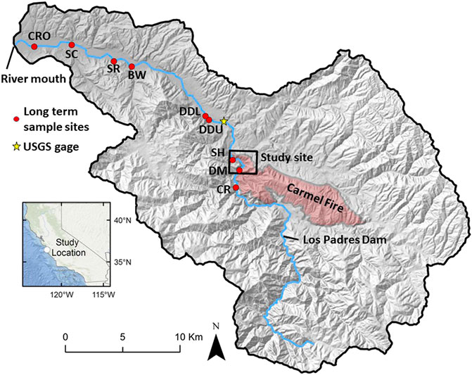
FIGURE 1. Debris flow study site on a shaded relief map of the Carmel River watershed of central coastal California. Study site includes northwestern margin of 2020 Carmel Fire. Former San Clemente Dam site is 30 upstream (south) of DM sample site. Red circles are long term substrate sampling sites fully described by Harrison et al. (2018). Yellow star is USGS Robles del Rio stream gage site 11143200.
San Clemente Dam was removed in 2015 with the anticipation that passive restoration of gravel and large wood transport past the dam site would gradually improve downstream spawning conditions (Boughton et al., 2016). A unique aspect of this dam removal was that most of the reservoir sediment was engineered to remain in place, so it was not available to replenish spawning gravel downstream (Harrison et al., 2018). In 2017, incision, widening, and avulsion in a short reach of river perched on unconsolidated reservoir sand and gravel generated a post-dam sediment pulse of sand and small gravel that covered spawning beds and locally filled pools and runs along more than 30 km of channel downstream to the mouth of the river (Harrison et al., 2018). Short-lived, fine-grained sediment pulses, supplied by erosion of relatively fine-grained reservoir sediment, are expected (Doyle et al., 2003; Major et al., 2012; Randle et al., 2015; Wang and Kuo 2016). The two-year gap between dam removal and a significant post-dam sediment pulse on the Carmel River was unusual. Harrison et al. (2018) ascribed the delay to climate variability typical of the regional Mediterranean climate. Their study ended two years after dam removal, before the life span of the sediment pulse could be determined.
Downstream sedimentary and geomorphic response to dam removal can vary considerably in magnitude, style, and duration (Kibler et al., 2011, Tullos et., al, 2014, East et al., 2015; Foley et al., 2017). Numerical modeling and small-scale flume experiments suggest that sediment pulses from a wide range of sources will evolve and decay through some combined proportion of translation and dispersion (Lisle et al., 2001; Sklar et al., 2009). In contrast, a recent landscape-scale study of post-dam sediment pulses hinted that the translation-dispersion wave-behavior ideals are simplistic (Wohl and Cenderelli 2000; East et al., 2018). East et al. (2018) report that the style and duration of sediment pulse behavior relies on a combination of climate, gradient, large wood, pulse magnitude, and grain size. Our work includes watershed-scale descriptions of a post-dam sediment pulse with a focus on impacts to steelhead spawning habitat.
Harrison et al. (2018) conducted a Before-After-Control-Impact (BACI) study to assess the magnitude and duration of steelhead habitat impacts forced by a sediment pulse following San Clemente Dam removal. Using a habitat suitability model modified from Dettman and Hanna (1991), they found that in addition to spawning-gravel impairment along most of the river, gravel deposition immediately downstream of the former dam had locally improved spawning habitat (Harrison et al., 2018). Our work reanalyzes the 2013 to 2017 Harrison et al. (2018) grain size data set (East et al., 2017), and adds an additional four years (2018–2021) to further assess the temporal and spatial substrate impacts generated by the post-San Clemente Dam sediment pulse.
A sustainable source of spawning sized gravel in the Carmel River is required to foster recovery of steelhead in the post-dam era. Gravel of the appropriate size for redd construction was abundant upstream of the relict reservoir material in 2017 (site “CR” of Figure 1; Harrison et al., 2018; East et al., 2017), but that material did not reach the lower river in significant quantity in 2017 despite the potential for bedload transport generated by two 10-year and one 25-year to 30-year flood event in that year (Harrison et al., 2018; Smith et al., 2020). The long-term re-establishment of significant gravel transport might therefore hinge on removal of Los Padres Dam, located 7 km higher in the watershed (Figure 1). It appears that near-term recovery of spawning gravel in the lower Carmel River will rely upon direct recruitment of colluvial material from canyon walls rather than reconnection with upstream sources. Our study focuses on direct recruitment as a potential gravel source.
The upper Carmel River watershed includes pervasively fractured and faulted granodiorite and metamorphic rocks (Smith et al., 2004) that are the ultimate source of bedload and spawning gravel. The colluvial slopes transport gravel to the valley bottom, and sometimes directly to the stream by dry ravel, landslides, and debris flows. Bathymetric data from the Los Padres Reservoir (Figure 1) provide insights into the conditions that foster bedload recruitment in the Carmel River watershed. Precise re-surveys of the bathymetry and surrounding topography document the episodic nature of reservoir capacity loss (Figure 2). The reservoir capacity dropped from 2,709 to 1,030 acre-feet (38%) between construction in 1941 and the most recent survey in 2017 (MEI, 2005; Smith et al., 2009; 2018). Most capacity loss occurred in years when wildfire was followed by a very wet rainfall season (Figure 2). The combined impact of just two fires, the Marble Cone and Soberanes, accounted for 66% of the long-term capacity loss (Hecht 1981; Smith et al., 2018). The need for both fire and intense rain for bedload recruitment is further supported by noting that the expansive Basin-Complex fire did not immediately lead to loss of reservoir capacity, while the similar Soberanes fire preceded a 7% drop in capacity. A wet winter following the Soberanes Fire was the only obvious difference between the two events (Richmond 2009). The bulk of reservoir-filling material came to rest in the reservoir delta top, and virtually no sediment reached the distal, deep basin floor, indicating that the post-Soberanes Fire sediment was chiefly bed load rather than suspended material. Given the highly fractured condition of local bedrock, the bedload recruited from fire-mediated slope failure likely contains abundant gravel appropriate for spawning habitat. Our current study quantifies the amount of spawning gravel present in several fire-related debris flows in the Carmel River watershed and explores their potential negative and positive impacts on spawning habitat.
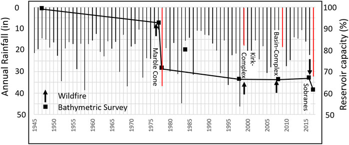
FIGURE 2. Annual rainfall at San Clemente Dam and reservoir capacity at Los Padres Reservoir. Red-highlighted rainfall years occurred immediately after a wildfire. Data from Smith et al. (2009), Smith et al. (2018). Bathymetric survey in 1984 is problematic, given that no dredging occurred to increase capacity. It is ignored in our analysis.
The 650 km2 Carmel River watershed drains the northern terminus of the Santa Lucia Mountains to the Pacific Ocean (Figure 1). The river flows in response to winter storms in a highly variable Mediterranean climate (Figure 3; Boughton et al., 2016; Harrison et al., 2018). The highest flows and greatest geomorphic change typically occur during atmospheric rivers that sporadically convey intense rains to coastal central California.

FIGURE 3. Runoff hydrograph for study period. Approximate return period indicated based upon Log-Pearson III frequency analysis. Data from USGS Robles del Rio gage (site 11143200; Figure 1).
Figure 3 provides context for the post-dam sediment response. Dam removal was immediately followed by a peak flow less than the 2-year event (Q2) in 2016 and then two Q10 and a ∼ Q25 events in 2017. The high flows of 2017 resulted in the post-dam sediment pulse and significant channel morphology change downstream (Harrison et al., 2018). The next year with enough discharge and duration to significantly rework the river bed was 2019 (Figure 3).
California experienced an historic fire season in summer and fall of 2020 giving rise to an opportunity to study the geomorphic and ecological wildfire impacts. The Carmel Fire started in August 2020 and was contained in early September 2020 after burning nearly 7,000 acres (WERT 2020). The fire intensely burned chaparral vegetation on steep slopes between two of the long-term monitoring sites studied by Harrison et al. (2018) and continued in the present study, providing a rare opportunity to observe and quantify both the production of post-fire debris flows, but to also directly assess their impact on channel substrate (Figure 4).
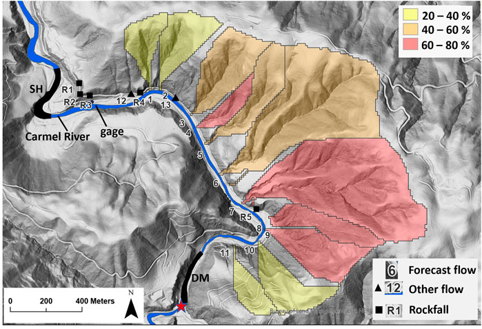
FIGURE 4. Shaded relief map of debris flow study site. Eleven colored regions are watersheds with USGS debris flow likelihood (% chance), given a peak 15 min duration rainfall intensity of 24 mm/hr (USGS 2020). DM and SH are the long-term gravel sampling sites located upstream and downstream, respectively, of the study basins (numbers). Position of tipping bucket rain gage indicated. Red star is site of former San Clemente Dam. Carmel River flow is generally northward in this map.
Post-fire debris flows are preconditioned where intense fire has denuded steep colluvial slopes. Both the probabilities and volumes of post-fire debris flows can be estimated by logistic regression (Cannon et al., 2010; Gartner et al., 2014; Staley et al., 2016; Staley et al., 2017). The unprotected colluvial layer on steep burned slopes with reasonably high clay content soils have a predictable failure probability when rain intensity reaches or exceeds approximately 24 mm/hr for a 15 min window (Staley et al., 2016; Staley et al., 2017). The study site slopes had between 20 and 80% chance of generating debris flows directly into the Carmel River bed.
Debris flow prediction models indicated a reasonably high probability of activity in the study area, conditioned on a rain event in excess of 15-min duration 24 mm/hr intensity. Water year 2021 was a drought year with very few storms. On January 27th, an atmospheric river brought a single, short-lived rain event that exceeded the threshold for debris flow generation. The storm runoff produced the only flood response in the Carmel River that year (Figure 3).
We have two main goals. First, we further evaluate the magnitude and duration of the post-dam sediment pulse on the Carmel River by extending and reanalyzing the data (East et al., 2017) used by Harrison et al. (2018). Second, we fully describe and interpret several fire-mediated debris flows impacting the Carmel River near two of our long-term study sites, a rare opportunity afforded by the 2020 Carmel Fire. Lastly, we interpret the grain size results in terms of temporal and spatial impact on steelhead spawning habitat.
Our study design, sites, and channel substrate sampling methods follow Harrison et al. (2018). We quantified bed grain size at 9 sites with one site above the former San Clemente Dam and the remainder distributed along the 30 km of channel below the dam site (Figure 1). We used the site upstream of the former dam as the control in a BACI study design to assess dam removal impacts on spawning gravel. Each site included 4 or 6 benchmarked transects distributed in riffle, pool, and run morphological units. One hundred grain intermediate-axis measurements were collected at each transect using a 20-count quadrat (1 m × 1 m) at each of 5 evenly spaced locations. A transect represents the sample unit for the BACI statistical analysis. Data were collected in 2 of the 3 years before dam removal, and nearly annually thereafter to follow the evolution of the sediment pulse.
The pooled grain size data at each transect were used to calculate the percentage of particles in the bed that fell between 32 and 90 mm, a range that includes the typical steelhead nest building material. Lastly, we used Wilcoxon rank sum in the BACI analysis to assess the magnitude and longevity of dam removal impacts on spawning gravel. Given that the 2017 sediment pulse diminished spawning habitat by blanketing the pre-existing spawning gravel patches, we interpreted an increase in spawning gravel through time at downstream sites to reflect either bed exhumation driven by sediment pulse attenuation or the re-introduction of additional spawning gravel from upstream sources.
We assessed the potential impacts of post-fire debris flows on spawning gravel by observing and quantifying several flows in winter 2021. To quantify rain intensity, we deployed an event-based Onset RG3-M tipping rain gage near to the study site and away from obstructions (Figure 4). The gage was deployed following the Carmel Fire and before any post-fire precipitation events. To determine debris flow timing, we mounted two time-lapse cameras aimed at two canyon mouths (7 and 8 of Figure 4). The cameras were set to trigger at 15 min intervals. Rain intensity associated with debris flow initiation was determined by comparing time synchronized data of the cameras and rain gage. The rain gage was located 730 and 890 m away from the cameras, close enough to reduce potential time lag errors between the instruments.
Individual rock falls and debris flows were topographically surveyed and mapped by 3 Nikon total station. Survey points at sites 8 and 9 included a combination of total station shots and drone photogrammetry (4 k camera on Phantom 4 Pro) processed in Pix4d software. Digital elevation models (DEM) created for each deposit were georeferenced and volumes were estimated by differencing the deposit DEM and a 1 m resolution LiDAR-based DEM (USGS 2019). We visually determined which deposits had contributed gravel to the Carmel River by noting whether or not the snout had been eroded by the high flow associated with the January storm. We performed particle grain size counts on a subset of the debris flow snouts to estimate the percent of the deposits that were appropriate for steelhead nests, and to estimate the relative abundance of muddy matrix that might negatively impact benthic habitat.
The large-grained, rounded, algae-coated substrate present at the site in 2021 presented an excellent substrate for identifying any new gravel (angular, grey, clean gravel) introduced from debris flows. To assess the impact on the Carmel River channel we walked the channel between the debris flow sites to visually record the presence of newly-recruited gravel, and performed, quadrat-based grain size counts on four transects near the downstream limit of the debris flow study area. We analyzed the impact using a BACI approach employing data from the long-term study sites located immediately upstream (control) and downstream (impact) of the debris flow study area. We also compared the percent spawning gravel at those sites to the data collected near the debris flows and within the debris flow deposits.
Nine years of grain size data that span the removal of San Clemente Dam indicate that spawning-size gravel abundance diminished downstream of the dam site in 2017, relative to the control site, and has not yet recovered (Figure 5; Table 1). The downstream sites (impact) lost spawning gravel when the dam was removed (Figure 5; Wilcoxon: W = 12,482, p = 0.002), in contrast to the upstream site (control), which has remained stable (Figure 5; Wilcoxon: W = 221, p = 0.1).
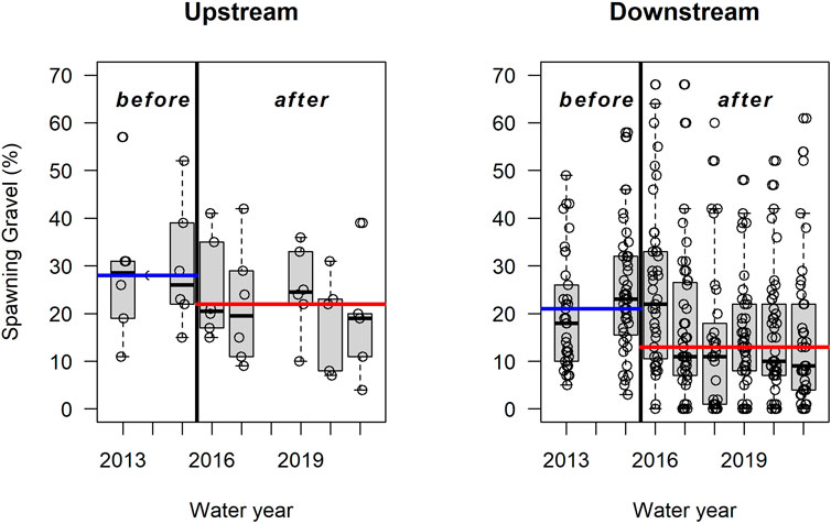
FIGURE 5. Boxplots of transect percent spawning gravel (between 32 and 90 mm) at the upstream (control) site and combined downstream (impact) sites through time. Overall before and after median values are shown in colored horizontal lines. Sizes are intermediate axis dimensions.

TABLE 1. Time series of percent of gravel between 32 and 90 mm in the bed of the Carmel River at the study sites. Site CR is upstream of the former San Clemente Dam. All other sites are below the dam site. Site locations in Figure 1. No data were collected in 2014.
High magnitude flows in 2017 generated a pulse of pool-filling sand and fine-gravel eroded from both unstable reservoir deposits (Harrison et al., 2018), and a river construction project (Smith et al., 2020). Existing spawning gravel was buried by a carpet of finer bed material that impacted all sites in the lower gradient reaches of the river (Figure 6; Harrison et al., 2018). The most recent grain size data (2021) show that the lowermost sites may be recovering as the 2017 sediment pulse washes away to expose the pre-dam removal gravel layer. In contrast, the remaining upstream sites had below average percent spawning gravel in 2021 (Figure 6). If the downstream sites were recovering spawning gravel through additions from upstream sources, we would expect the upstream sites to be showing the recovery first.
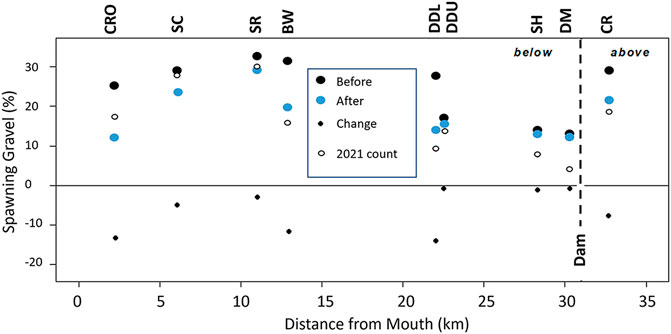
FIGURE 6. Changes in mean percent spawning gravel following dam removal at sites above and below the former San Clemente Dam (vertical bar). Site locations shown in Figure 1. Data in Table 1.
The 3 km long reach of river immediately downstream of the former dam (sites DM and SH; Figure 1) were armored by large cobble and boulder bed material at the time that the dam was removed (East et al., 2017). Following dam removal those sites remained generally too coarse for steelhead nests, except for pools and runs, which were filled by sand and fine gravel that was too fine (Chow et al., 2016; Harrison et al., 2018). These impaired conditions lasted through to the 2020 sampling season.
In 2021, we monitored the river valley between those two sites (DM and SH) to assess the impact of post-fire debris flows on spawning gravel abundance. The steep, granitic, chaparral-covered slopes were denuded by the Carmel Fire (Figure 7). At least 17 post-fire slope failure events occurred in the study reach (Table 2). Time-lapse cameras aimed at two basin mouths indicated that the slopes failed sometime between 0315h and 0330h PST on January 27th, 2021. The debris flows occurred when rain intensity surpassed the 15-minute-duration debris flow threshold of 24 mm/hr, in keeping with forecasts modeled by the United States Geological Survey (Figure 8; USGS 2020; Staley et al., 2017; Gartner et al., 2014).
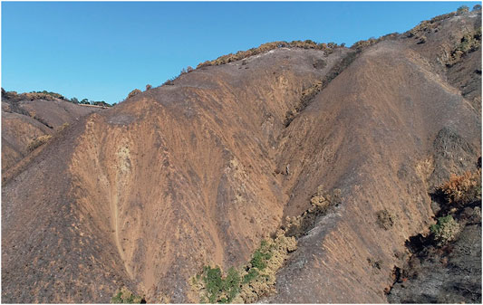
FIGURE 7. Burned slopes before the winter rains of 2021. This example is basin seven of Figure 4 and Table 2.
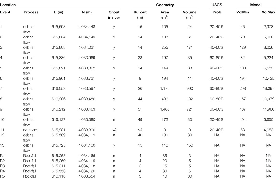
TABLE 2. Debris flow and rockfall deposit inventory at the study site. Site locations in Figure 4. Locations are UTM NAD 83 UTM zone 10 N. USGS model values are debris flow forecasts from USGS (2020). VolMin and VolMax show the range of debris flow volume estimates modeled by USGS (2020).

FIGURE 8. Fifteen-minute duration precipitation intensity during the debris-flow triggering storm. Vertical lines bound the time that the debris flows enter the view of the time-lapse cameras. Horizontal line indicates the threshold intensity predicted to produce debris flows (USGS 2020).
Rilling and gullying were pervasive on the slopes that generated debris flows. Erosional features are consistent with runoff-dominated flows rather than soil-slip related processes. Runoff-dominated flows are thought to be favored on intensely burned slopes where soil infiltration is impaired (Cannon et al., 2000).
Of the 13 debris flows in the study area, 11 were successfully predicted by the USGS model and 10 had volumes that were within the predicted range (Table 2). Flows 12 and 13 and all rockfall events were not predicted by the USGS models because the source basins fell below the minimum 0.2 km2 minimum threshold for inclusion models. Site 11 (Table 2; Figure 4) was the only basin in the study area to fail to produce a flow despite having a published flow probability of 20–40%. The site 11 basin differed from the other sites in having oak woodland rather than chaparral habitat, lower burn intensity, and several abandoned road traces crossing the slope that likely reduced the runoff velocity and increased colluvium stability (Figure 4). Ten of the debris flows we studied entered the flood water of the Carmel River (Figure 9; Table 2), with the potential to impact the substrate. Visual inspection of the debris flow snouts where they had been eroded by the river indicated that the deposit matrices were virtually mud free.
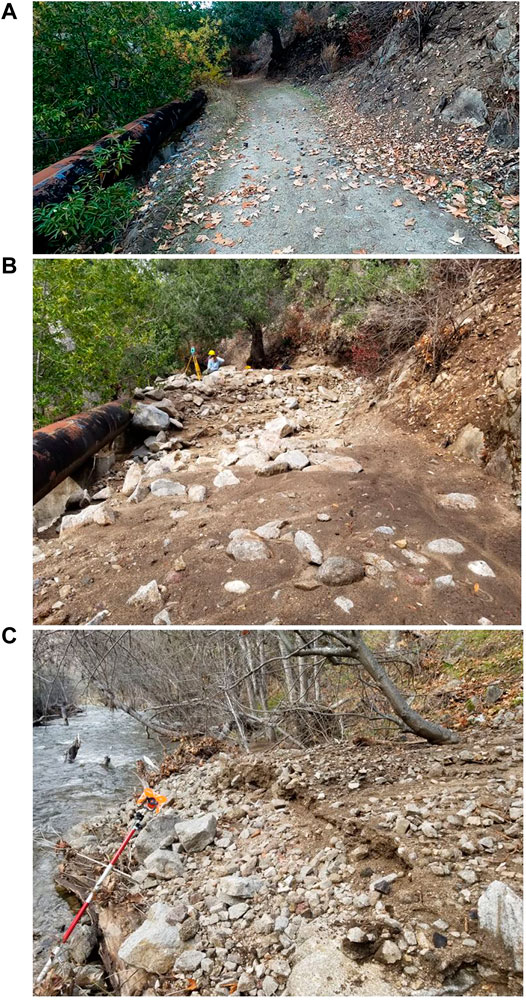
FIGURE 9. Debris flow from basin seven (Figure 4; Table 2). (A) road and pipeline at toe of slope before debris flow. (B) Same view after debris flow (person and total station for scale). (C) Debris flow snout eroded by high water following January 27 storm runoff (1.5 m range pole for scale).
The debris flow snouts had a median of 45% of spawning-sized gravel (Figure 10). Although the debris flows were rich in spawning-sized gravel, and several debris flows reached the river, both reconnaissance observations and a BACI-sampling design of pebble counts in the Carmel River channel show that no significant patches or bars of new gravel were present in the study area when the flood waters receded (Figure 10). Spawning gravel in the Carmel River channel before and after the debris flow event was approximately 12% of the bed, and it was too dispersed to be useful for redds. Particle counts near the debris flow sites (“channel” of Figure 10) included 9% that had been recruited directly from the recent debris flows. Just 3% of the particles located near the debris flows were new particles that also fell within the spawning-size range.
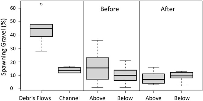
FIGURE 10. Percent spawning gravel in debris flow snouts and Carmel River channel near the debris flows (left panel). BACI assessment (right two panels) uses the 2020 data (before) and 2021 data (after) of long term study sites DM (above) and SH (below). Site locations in Figure 4.
A paucity of spawning gravel may have contributed to the decline of the Carmel population of steelhead. Counter to anticipated results (Boughton et al., 2016), our BACI analysis of percent spawning gravel spanning 9 years indicates that availability of gravel suitable for nest building decreased downstream of the dam site following dam removal (Figure 5). A pulse of pool-filling sand and small gravel swept downstream to the river mouth in 2017. While downstream sites lost gravel to burial by sand, the upstream reach (within 3 km of the dam) has remained generally armored by large cobble and boulders. Apparently, the post-dam sand pulse passed by most of this upper reach. This observation is in keeping with flume experiments where small-scale sediment waves completely translate across a previously-armored substrate (Sklar et al., 2009). The lack of thick deposits in the armored upper reach (outside of pools) is also expected because the gradient is somewhat higher there (1%–0.8%) than at downstream reaches (∼0.2%) (Harrison et al., 2018). In 2021 the percent of spawning gravel was still diminished below pre-dam conditions, but the two sites closest to the mouth showed slight recovery (Figure 6). We are reluctant use “wave” behavior to describe the sediment pulse because wave geometry (thin at ends, thick in middle; Lisle et al., 2001) is not present. Instead, the pulse has a longitudinally-discontinuous geometry, with gaps in some of the riffles, as described by Harrison et al. (2018). As the sediment washes through, it is moving from pool to pool on the way to the sea, behavior noted in another dam related sediment pulse (e.g., Wohl and Cenderelli, 2000). If the downstream two sites are improving, rather than showing natural variability, it reflects the exhumation of spawning gravel through attenuation of the downstream terminus of the sediment pulse. This behavior is also not typical of previously-described post-dam sediment pulses (Cashman et al., 2021). We acknowledge the difficulty in interpreting complex bed dynamics using single annual measurements at widely-spaced, fixed locations on the river.
Although the dam came down in 2015, there was little change downstream of the dam until high flows of 2017 initiated the sand wave that covered or diluted existing spawning gravel. (Figure 5). This lagged response was the result of highly variable rainfall and runoff sequencing (Harrison et al., 2018). Previous studies have determined that post-dam sediment waves can last between 1 and 10 years (Jacobs et al., 2021). A disproportionate number of drought years, when bedload transport is very limited, has extended the San Clemente dam removal impact to six years, and there is little evidence that the sediment pulse is waning except perhaps near the river mouth (Figure 6).
Improvement in spawning gravel abundance was predicted to occur from the transport of new material from upstream sources. The lack of recovery may be the background condition imposed by gravel-trapping behind the Los Padres Dam. If so, spawning gravel will continue to be a limiting factor for steelhead until Los Padres dam is also removed. A temporary increase in spawning gravel noted throughout the study area in 2019 (Figure 5) was likely the result of bedload transport and winnowing of fine particles during two approximately Q5 flow events (Figure 3).
Reservoir studies in the upper Carmel watershed show that abundant bedload can be recruited if a wet year immediately follows wildfire (Figure 2). This pattern was locally witnessed when the January 27, 2021 rains triggered general failure of colluvial slopes adjacent to the Carmel River immediately below the former San Clemente Dam site. The debris flows contained virtually no mud or ash, so they had little potential to negatively impact the channel benthic habitat (Minshall 2003; Flitcroft et al., 2016; Jacobs 2021). The debris flows were sourced in burned chaparral habitat, so there could be no habitat benefits of new large wood pieces (Flitcroft et al., 2016). Ultimately, the debris flows did not contribute enough new gravel to the 10 m-wide river channel to immediately replenish spawning gravels, although the cumulative volume of deposited material was 2,500 m3 and the grain sizes were suitable (Figures 9, 10; Table 2). The debris flows had to traverse a rural road (Figure 9) and, in some places, a relict 1.5 m diameter pipeline. These impediments slowed the debris flow runout lengths, leading to most material being stored in the canyon bottom rather than extending far into the river. In a more natural landscape, the cumulative benefit of the debris flows might have been much greater. Future high flows will continue to erode the flow snouts, so benefits to local gravel supply might be forthcoming (Jacobs et al., 2021).
The complex impacts of climate change on interdependent human, geomorphic, and ecological systems are being considered and inventoried (East and Sankey, 2020; Jacobs et al., 2021). Regional models of climate change point to two variables that will influence recruitment of spawning gravel from the slopes of the Carmel watershed. First, conditions are forecast to be dryer, leaving more fire fuel available early in the fire season (e.g., Ullrich et al., 2018). Second, annual rain will be delivered in fewer, but more intense, storms (e.g., Swain et al., 2017). Our debris-flow study period was a drought year with one intense storm that followed an intense fire, so it is a direct analog for future climate conditions at the site. Our data suggest that a combination of higher fire frequency and more intense precipitation will increase the rate of spawning gravel recruitment in the Carmel watershed in future decades.
The raw data supporting the conclusions of this article will be made available by the authors, without undue reservation.
DS designed the research. JS, LM, SW and KM collected field data for the debris flow study. MW, DC, AF, and JR analyzed geospatial datasets and the USGS debris flow models, produced draft maps and figures, and analyzed drone video. JK, CS, and RK led field collection teams and data analysis for the long-term study. All the authors contributed to the article in early drafts and approved the submitted version.
Data collection for this work was funded from various sources including Monterey Peninsula Water Management District, NOAA Marine Fisheries, and California American Water. This research was partially funded by CSU Council on Ocean Affairs, Science & Technology (COAST) and the US Geological Survey Landslides Hazard Program.
The authors declare that the research was conducted in the absence of any commercial or financial relationships that could be construed as a potential conflict of interest.
All claims expressed in this article are solely those of the authors and do not necessarily represent those of their affiliated organizations, or those of the publisher, the editors, and the reviewers. Any product that may be evaluated in this article, or claim that may be made by its manufacturer, is not guaranteed or endorsed by the publisher.
Students of 2021 GEOL 460 at CSUMB played a supporting role in this project. We appreciate the collaboration of Larry Hampson and Jonathon Leer (both with Monterey Peninsula Water Management District). This work stems from a long collaboration with Amy East (USGS) Joshua Logan (USGS), Lee Harrison (NOAA), Lea Bond (NOAA), and Colin Nicol (NOAA). Amy East, Lee Harrison, and Drs. Milton and Diana Lieberman provided substantive suggestions for manuscript improvement. We greatly appreciate the critical reviews and supportive suggestions of Dr. Peter Nelson and Dr. Shawn Chartrand. We recognize the pioneering work of Sheldon Lieker, John Silveus, and August Delforge in setting the benchmarks and surveying the first data sets in 2013.
Boughton, D. A., East, A., Hampston, L., Kiernan, J., Leiker, S., Mantua, N., et al. (2016). Removing a Dam and Re-routing a River: Will Expected Benefits for Steelhead Materalize in Carmel River, California? NOAA Technical Memorandum, NOAA-TM-NMFS-SWFSC-553. Santa Cruz, CA: US Department of Commerce. Southwest Fisheries Science Center, 89.
Cannon, S. H., Kirkham, R. M., and Parise, M. (2000). Wildfire-related Debris-Flow Initiation Processes, Storm King Mountain, Colorado. Amsterdam (NL)Geomorphology 39 (3–4), 171–188. doi:10.1016/S0169-555X(00)00108-2
Cannon, S. H., Gartner, J. E., Rupert, M. G., Michael, J. A., Rea, A. H., and Parrett, C. (2010). Predicting the Probability and Volume of Postwildfire Debris Flows in the Intermountain Western United States. Geol. Soc. America Bull. 122 (1-2), 127–144. doi:10.1130/B26459.1
Cashman, M. J., Gellis, A. C., Boyd, E., Collins, M. J., Anderson, S. W., McFarland, B. D., et al. (2021). Channel Response to a Dam‐removal Sediment Pulse Captured at High‐temporal Resolution Using Routine Gage Data. Earth Surf. Process. Landforms. doi:10.1002/esp.5083
Chow, K., Fields, J., Flores, S., Hart, K., Kleven, A., Luna, L., et al. (2016). San Clemente Dam Removal Sediment Impacts: Year One Report. Monterey (CA): Watershed Institute, California State University Monterey Bay, 1–38.
Doyle, M. W., Stanley, E. H., and Harbor, J. M. (2002). Geomorphic Analogies for Assessing Probable Channel Response to Dam Removal. J. Am. Water Resour. Assoc 38 (6), 1567–1579. doi:10.1111/j.1752-1688.2002.tb04365.x
East, A. E., Harrison, L., Smith, D. P., Bond, R., Logan, J. B., Nicol, C., et al. (2017). River-channel Topography, Grain Size, and Turbidity Records from the Carmel River, California, before, during, and after Removal of San Clemente Dam. U.S. Geol. Surv. Data Release. doi:10.5066/F74M93HF
East, A. E., Logan, J. B., Mastin, M. C., Ritchie, A. C., Bountry, J. A., Magirl, C. S., et al. (2018). Geomorphic Evolution of a Gravel‐Bed River under Sediment‐Starved versus Sediment‐Rich Conditions: River Response to the World's Largest Dam Removal. J. Geophys. Res. Earth Surf. 123, 3338–3369. doi:10.1029/2018JF004703
East, A. E., Pess, G. R., Bountry, J. A., Magirl, C. S., Ritchie, A. C., Logan, J. B., et al. (2015). Large-scale Dam Removal on the Elwha River, Washington, USA: River Channel and Floodplain Geomorphic Change. Geomorphology 228, 765–786. doi:10.1016/j.geomorph.2014.08.028
East, A. E., and Sankey, J. B. (2020). Geomorphic and Sedimentary Effects of Modern Climate Change: Current and Anticipated Future Conditions in the Western United States. Rev. Geophys. 58 (4), e2019RG000692. doi:10.1029/2019RG000692
Flitcroft, R. L., Falke, J. A., Reeves, G. H., Hessburg, P. F., McNyset, K. M., and Benda, L. E. (2016). Wildfire May Increase Habitat Quality for spring Chinook salmon in the Wenatchee River Subbasin, WA, USA. For. Ecol. Management 359, 126–140. doi:10.1016/j.foreco.2015.09.049
Foley, M. M., Bellmore, J. R., O'Connor, J. E., Duda, J. J., East, A. E., Grant, G. E., et al. (2017a). Dam Removal: Listening in. Water Resour. Res. 53 (7), 5229–5246. doi:10.1002/2017wr020457
Gartner, J. E., Cannon, S. H., and Santi, P. M. (2014). Empirical Models for Predicting Volumes of Sediment Deposited by Debris Flows and Sediment-Laden Floods in the Transverse Ranges of Southern California. Eng. Geology. 176, 45–56. doi:10.1016/j.enggeo.2014.04.008
Harrison, L. R., East, A. E., Smith, D. P., Logan, J. B., Bond, R. M., Nicol, C. L., et al. (2018). River Response to Large-Dam Removal in a Mediterranean Hydroclimatic Setting: Carmel River, California, USA. Earth Surf. Process. Landforms 43 (15), 3009–3021. doi:10.1002/esp.4464
Hecht, B. (1981). “Sequential Changes in Bed Habitat Conditions in the Upper Carmel River Following the Marble-Cone Fire of August 1977,” in California Riparian Systems: Ecology, Conservation and Productive Management. Editors R. E. Warner, and K. M. Hendrix (California: University of California Press), 134–141.
Jacobs, G. R., Thurow, R. F., Buffington, J. M., Isaak, D. J., and Wenger, S. J. (2021). Climate, Fire Regime, Geomorphology, and Conspecifics Influence the Spatial Distribution of Chinook salmon Redds. Trans. Am. Fish. Soc. 150 (1), 8–23. doi:10.1002/tafs.10270
Kibler, K., Tullos, D., and Kondolf, M. (2011). Evolving Expectations of Dam Removal Outcomes: Downstream Geomorphic Effects Following Removal of a Small, Gravel-Filled Dam1. J. Am. Water Resour. Assoc. (Jawra) 47 (2), 408–423. doi:10.1111/j.1752-1688.2011.00523.x
Kondolf, G. M., Sale, M. J., and Wolman, M. G. (1993). Modification of Fluvial Gravel Size by Spawning Salmonids. Water Resour. Res. 29 (7), 2265–2274. doi:10.1029/93WR00401
Lisle, T. E., Cui, Y., Parker, G., Pizzuto, J. E., and Dodd, A. M. (2001). The Dominance of Dispersion in the Evolution of Bed Material Waves in Gravel-Bed Rivers. Earth Surf. Process. Landforms 26 (13), 1409–1420. doi:10.1002/esp.300
Miller, D. J., Burnett, K., and Benda, L. (2008). Factors Controlling Availability of Spawning Habitat for Salmonids at the basin Scale. Am. Fish. Soc. 65, 103–120.
Minshall, G. W. (2003). Responses of Stream Benthic Macroinvertebrates to Fire. For. Ecol. Management 178 (1-2), 155–161. doi:10.1016/s0378-1127(03)00059-8
Richmond, S. (2009). Post-fire Channel Response: A Comparison between the 1977 Marble Cone Fire and 2008 Basin Complex Fire on the Upper Carmel River. Berkeley: University of California. Unpublished Master’s Thesis.
Scheurer, K., Alewell, C., Bänninger, D., and Burkhardt-Holm, P. (2009). Climate and Land-Use Changes Affecting River Sediment and Brown trout in alpine Countries-A Review. Environ. Sci. Pollut. Res. 16 (2), 232–242. doi:10.1007/s11356-008-0075-3
Sklar, L. S., Fadde, J., Venditti, J. G., Nelson, P., Wydzga, M. A., Cui, Y. T., et al. (2009). Translation and Dispersion of Sediment Pulses in Flume Experiments Simulating Gravel Augmentation below Dams. Water Resour. Res. 45, W08439. doi:10.1029/2008wr007346
Smith, D. P., Kvitek, R., Aiello, I., Iampietro, P., Quan, S., Paddock, E., et al. (2009). Fall 2008 Stage-Volume Relationship for Los Padres Reservoir, Carmel River, California: Prepared for the Monterey Peninsula Water Management District. California: The Watershed Institute, California State University Monterey Bay, 30. Publication no. WI-2009-2.
Smith, D. P., Kvitek, R., Iampietro, P., and Consulo, P. (2018). Fall 2017 Stage-Volume Relationship for Los Padres Reservoir, Carmel River, CaliforniaPrepared for the Monterey Peninsula Water Management District. California: The Watershed Institute, California State University Monterey Bay, Publication no. WI-2018-05, 21.
Smith, D. P., Kortman, S. R., Caudillo, A. M., Kwan‐Davis, R. L., Wandke, J. J., Klein, J. W., et al. (2020). Controls on Large boulder Mobility in an “Auto‐naturalized” Constructed Step‐pool River: San Clemente Dam Removal and Reroute Project, Carmel River, California, USA. Earth Surf. Process. Landforms 45(9), 1990–2003. doi:10.1002/esp.4860
Staley, D. M., Negri, J. A., Kean, J. W., Laber, J. L., Tillery, A. C., and Youberg, A. M. (2017). Prediction of Spatially Explicit Rainfall Intensity–Duration Thresholds for post-fire Debris-Flow Generation in the Western United States. Geomorphology, 278, 149–162. doi:10.1016/j.geomorph.2016.10.019
Staley, D. M., Negri, J. A., Kean, J. W., Tillery, A. C., and Youberg, A. M. (2016). Updated Logistic Regression Equations for the Calculation of post-fire Debris-Flow Likelihood in the Western United States: U.S. Geological Survey Open-File Report 2016-1106. Available at: https://pubs.usgs.gov/of/2016/1106/.
Swain, D. L., Langenbrunner, B., Neelin, J. D., and Hall, A. (2018). Increasing Precipitation Volatility in Twenty‐first‐century California. Nat. Clim. Change 8, 427–433. doi:10.1038/s41558‐018‐0140‐y
Tullos, D. D., Finn, D. S., and Walter, C. (2014). Geomorphic and Ecological Disturbance and Recovery from Two Small Dams and Their Removal. PLOS ONE. 9 (9). doi:10.1371/journal.pone.0108091
Ullrich, P. A., Xu, Z., Rhoades, A. M., Dettinger, M. D., Mount, J. F., Jones, A. D., et al. (2018). California's Drought of the Future: A Midcentury Recreation of the Exceptional Conditions of 2012–2017. Earth's Future 6, 1568–1587. doi:10.1029/2018EF001007
USGS (2020). Post-fire Debris-Flow Hazards: Carmel Fire. Monterey, CA. Available at: https://landslides.usgs.gov/hazards/postfire_debrisflow/detail.php?objectid=276.
Watershed Emergency Response Team Evaluation (WERT) (2020). River and Carmel Fires Report. CEU-BEU_004024 and CA-BEU-004081. Monterey, CA: CAL FIRE San Benito Monterey Unit, 164.
Westerling, A. L., Hidalgo, H. G., Cayan, D. R., and Swetnam, T. W. (2006). Warming and Earlier spring Increase Western U.S. forest Wildfire Activity. Science 313, 940–943. doi:10.1126/science.1128834
Williams, T. H., Spence, B. C., Boughton, D. A., Johnson, R. C., Grady Reed Crozier, E., Mantua, N. J., et al. (2016). Viability Assessment for Pacific salmon and Steelhead Listed under the Endangered Species Act: Southwest. US: US Department of Commerce, NOAA Technical Memorandum NMFS.
Keywords: spawning gravel, dam removal, debris flow, wildfire, steelhead, Carmel River
Citation: Smith DP, Schnieders J, Marshall L, Melchor K, Wolfe S, Campbell D, French A, Randolph J, Whitaker M, Klein J, Steinmetz C and Kwan R (2021) Influence of a Post-dam Sediment Pulse and Post-fire Debris Flows on Steelhead Spawning Gravel in the Carmel River, California. Front. Earth Sci. 9:802825. doi: 10.3389/feart.2021.802825
Received: 27 October 2021; Accepted: 29 November 2021;
Published: 10 December 2021.
Edited by:
Edward A. Johnson, University of Calgary, CanadaReviewed by:
Peter Nelson, Colorado State University, United StatesCopyright © 2021 Smith, Schnieders, Marshall, Melchor, Wolfe, Campbell, French, Randolph, Whitaker, Klein, Steinmetz and Kwan. This is an open-access article distributed under the terms of the Creative Commons Attribution License (CC BY). The use, distribution or reproduction in other forums is permitted, provided the original author(s) and the copyright owner(s) are credited and that the original publication in this journal is cited, in accordance with accepted academic practice. No use, distribution or reproduction is permitted which does not comply with these terms.
*Correspondence: Douglas P. Smith, ZG9zbWl0aEBjc3VtYi5lZHU=
Disclaimer: All claims expressed in this article are solely those of the authors and do not necessarily represent those of their affiliated organizations, or those of the publisher, the editors and the reviewers. Any product that may be evaluated in this article or claim that may be made by its manufacturer is not guaranteed or endorsed by the publisher.
Research integrity at Frontiers

Learn more about the work of our research integrity team to safeguard the quality of each article we publish.