- 1State Key Laboratory of Soil Erosion and Dryland Farming on the Loess Plateau, Institute of Soil and Water Conservation, Chinese Academy of Sciences and Ministry of Water Resources, Yangling, China
- 2University of Chinese Academy of Sciences, Beijing, China
- 3Shaanxi Key Laboratory of Earth Surface System and Environmental Carrying Capacity, College of Urban and Environmental Sciences, Northwest University, Xi’an, China
The contradiction between economic growth, social development, and water environment deterioration represent significant challenges for river basin sustainable development. By constructing an indicator system of river basin sustainable development, the entropy method is adopted to conduct a quantitative evaluation of the cities sustainable development level for the Weihe River Basin in Shaanxi Province from 2009 to 2018, and the standard deviational ellipse is used to analyze the evolution of spatial distribution pattern of sustainable development in the study area. Furthermore, the obstacle degree model is applied to analyze the main obstacle factors restricting the improvement of river basin sustainable development. The results show that the sustainable development level of the Weihe River basin in Shaanxi Province improved slowly during the study period and significant regional differences among cities. This study provides a novel approach for future evaluation on sustainable development of the Weihe River basin and even the arid region in Northwest China, to achieve a win-win situation between economic and social development and ecological environment protection.
Introduction
With 1% yearly growth of global water consumption (Wada et al. 2016), it is speculated that by 2050, more than 50% of the world’s population will be chronically short of water (Roshan and Kumar, 2020). Water shortage will not only restrict social and economic development but also cause immeasurable damage to the ecological environment (Silva et al., 2019). Global water crisis is a barrier to sustainable development (Roshan and Kumar 2020); importance should be given to exploring the river basin sustainable development (RBSD).
Amid the unceasing appearance of global environment deterioration, resource depletion, population explosion, and other realistic problems, the concepts of sustainable development and the sustainable utilization of river basin have been recognized by many scholars. At present, the research on RBSD mainly focuses on the assessment of ecological health in the river basin Wu et al. (2020), Jamal et al. (2021); land use/cover changes and its environmental response in the river basin Shen and Ma (2020); optimization and management of water resources Chen et al. (2019), Ferreira et al. (2020); and ecological function zoning and ecological compensation of river basin (Melanie and John, 2018; Gao et al., 2019).
Much work has been done to RBSD during the past decades. A framework for quantitatively evaluating development sustainability was established with water-related eco-environmental carrying capacity as the core measure by Wang et al. (2014). Wang et al. (2019) used a pressure–state–response (PSR) model to quantify the sustainability of water resources in Beijing, China. D'Ambrosio et al. (2020) assessed the sustainability in water use at the basin scale through the water footprint. In recent years, evaluation methods such as system dynamics (Kotir et al. (2016), Pluchinotta et al. (2021), Song et al. (2018)) and sustainability index (Bui et al. (2019), Roobavannan et al. (2020)) have been widely used in the study of RBSD. However, with research concentrating on a single perspective, less attention was paid to the connection between the integrated socioeconomic development of the river basin and its water resources (Zhong et al., 2018). Besides, there is no unified and authoritative theoretical system for RBSD nor does it truly reflect the concept of sustainable development (Silva et al., 2020). Consideration is lacking in the coordinated development of society–economy–ecology to maximize the comprehensive benefits.
Some rivers in China suffer from problems such as the decline of sustainability and the deterioration of the natural environment caused by human activities (Fu et al., 2020). Among them, the problem of water shortage poses a threat to the sustainable development in arid and semiarid areas (Li J. et al., 2019). The Yellow River basin is a miniature of Asia and Africa’s water resource deficit (Chen Y.-p. et al., 2020). As the largest tributary of the Yellow River basin, the Weihe River basin (WRB) is crucial to the sustainable development of the Yellow River basin. The ecological environment of WRB is seriously degraded Wang et al. (2019) and water resources have an obvious restrictive effect on regional development. The mechanism and difference in the midstream of the Yellow River basin can be clarified through the study of WRB, and it also offered a reference for the development of the upstream and downstream in the Yellow River basin.
The entropy weight method, standard deviational ellipse, and obstacle degree model are employed in this article. The entropy method is used to calculate the weight of each indicator, which can provide the basis for the comprehensive evaluation of multiple indicators. It avoids the deviation caused by human factors and makes the evaluation more objective. The method has been used for the evaluation of electric power development (Zhao et al. (2020)), carbon emission (Cui et al. (2021)), the sustainable development capability of agriculture Li Q. et al., (2019), and many other fields. The standard deviational ellipse method analyzes the directivity of spatial distribution well and reflects the concentration degree of each element in the spatial pattern. Standard deviational ellipse was used to examine the effects of land use policy on the spatiotemporal changes in the area of surface water by Xu et al. (2018). Zuo et al. (2021) revealed a dynamic evolution process of ecological civilization construction. Du et al. (2019) investigated the relationship between economic growth and carbon emissions from the construction industry. The obstacle degree model is a mathematical statistical model to calculate the impact factor, and it is widely used in many aspects of comprehensive evaluation of ecological resources and environment such as cultivated land resources security Huang et al. (2021), water resource security (Zhang et al., 2019), etc.
In this article, an indicator system of RBSD is established to analyze the temporal and spatial variation of sustainable development with the case study of WRB in Shaanxi Province. Next, the obstacle degree model is introduced to investigate the main impediments that affect RBSD, with countermeasures put forward accordingly. The project has a theoretical value for implementing scientific development view and enriching sustainable development theory. As for realistic significance, WRB in the northwest arid region of China is selected as a specific case, providing operational and referable suggestions for remodeling the development and evolution process of different rivers.
Material and Methods
Study Area
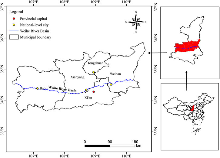
Weihe River basin (34°–37°N, 104°–110°E; Figure 1), originating from Niaoshu Mountain in Gansu Province, flows into the Yellow River basin in Shaanxi Province. It lies in the north of Qinling Mountain, south of Liupanshan Mountain, the east of Loess hilly and gully region, and the west of Guanzhong Plain. Located in the warm temperate zone, WRB in Shaanxi Province has a subhumid continental climate, with an annual mean temperature of 7.8–13.5°C and an annual precipitation of 500–800 mm (Zhao et al., 2016). The main stream of WRB in Shaanxi Province, a length of 502.40 km, covers a drainage area of 67,108 km2, accounting for 50% of the total drainage area of the Yellow River basin in Shaanxi Province. The average annual runoff of the whole river is 1.04 × 10¹⁰ m3, of which the runoff in Shaanxi Province is 6.27 × 10⁹ m3, with the flooding period (July to September) accounting for about 60% (Deng et al., 2020).
The Weihe River is the mother river of Shaanxi, related to the rise and fall of economic and social development in Shaanxi Province. The core of Guanzhong–Tianshui economic region, WRB, plays an important role in the western development strategy of China. By the end of 2018, the population of the study area grew to 2.45×10⁷ people and GDP 9.87×10¹⁴ yuan (Shaanxi Provincial Bureau of Statistics, 2019). The total water resources quantity in the study area, 7.25 × 10⁹ m3, only accounted for 1.95% of that in Shaanxi Province. Only covering one-third of the land area of Shaanxi Province, WRB in Shaanxi Province discharged over three-fourths of the wastewater in Shaanxi Province. The water supply and water consumption of WRB in Shaanxi Province compose more than half of Shaanxi Province, 57.50% and 59.37%, respectively (Shaanxi Province Department of Water Resources, 2018). This study involves five cities on the main stream of WRB in Shaanxi Province, including Xi’an, Tongchuan, Baoji, Xianyang, and Weinan.
In recent years, remarkable changes have taken place in WRB with the intensification of human activities and the rapid development of the regional economy and society. However, multiple issues have attracted public concern, such as insufficient water resources, aggravated water pollution, overexploitation of groundwater, and incomplete containment of soil and water loss. Therefore, the study on sustainable development of WRB in Shaanxi Province is of great significance for promoting green development of the economy and society in Shaanxi province.
Construction of Indicator System
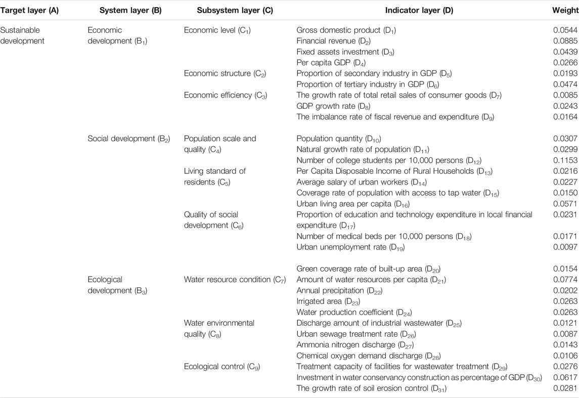
The indicator system was based on the United Nations Sustainable Development Goals (SDGs) and China’s National Plan on Implementation of the 2030 Agenda for Sustainable Development. To clarify the status of RBSD, this article regarded water resources as the core, the basin as a research space, and the complex system composed of human and nature in the basin as a research object. According to the construction principle of indicator system and covering the main environmental and socioeconomic issues contained in the concept of sustainable development with Chinese characteristics, the evaluation indicator is divided into a hierarchical system consisting of target layer (A), system layer (B), subsystem layer (C), and indicator layer (D).
The indicators were chosen for systematicness, completeness, representativeness, and accessibility. In terms of the actual situation, the water resource characteristics, and the evaluation content of WRB, 31 indicators were selected to construct the indicator system of RBSD (Table 1).
Calculation of Weight and the Level of Sustainable Development
To eliminate the magnitude difference among the data, the deviation standardization formula is adopted for each indicator, so that the results are all within the range of (0,1).
Positive Indicator
Negative Indicator
Here, xij and Yij are the original and normalized values of the ith indicator in the year j, respectively.
In information theory, entropy is a measure of uncertainty. According to the characteristics of entropy, the discrete degree of indicator layer can be measured by calculating the entropy value. The larger the discrete degree of indicator, the greater the influence of indicator on a comprehensive evaluation. The entropy method is used to quantify the information of each indicator with the Shannon entropy (Shannon, 1948). Information entropy is employed to calculate the weight of each indicator layer to achieve an objective quality evaluation.
Assuming that there are m evaluation objects and n evaluation indicators, a matrix A with n rows and m columns can be established:
The proportion Zij of the ith indicator in the year j is given as follows:
The entropy ki of the ith indicator is as follows:
The redundancy gi of the information entropy of the ith indicator is as follows:
The weight wi of each indicator is calculated as follows:
The comprehensive evaluation of RBSD is calculated as follows:
Obstacle Degree Model
In the process of sustainable development evaluation, it is not only necessary to measure the level of RBSD but also to understand the critical factors that affect RBSD. Therefore, the obstacle degree model (Chen Y. et al. (2020), Fan and Fang (2020)) is introduced to analyze the obstacle factors of RBSD so as to carry out the pathological diagnosis in a practical application. The formula is as follows:
where Qij represents the obstacle degree of the ith indicator in the year j, and Pij is the deviation degree of indicator i in year j.
Data
In view of accessible and limited data, this article chose 2009 to 2018 as the research period and five cities of WRB in Shaanxi Province were selected as samples to establish a comprehensive indicator system for the sustainable development of WRB in Shaanxi Province. Data were collected from the China Urban Statistical Yearbooks (2010–2019), Shaanxi Statistical Yearbooks (2010–2019), and Shaanxi Water Resources Bulletins (2009–2018). In addition, missing data were obtained by the interpolation method.
Results
Temporal Analysis
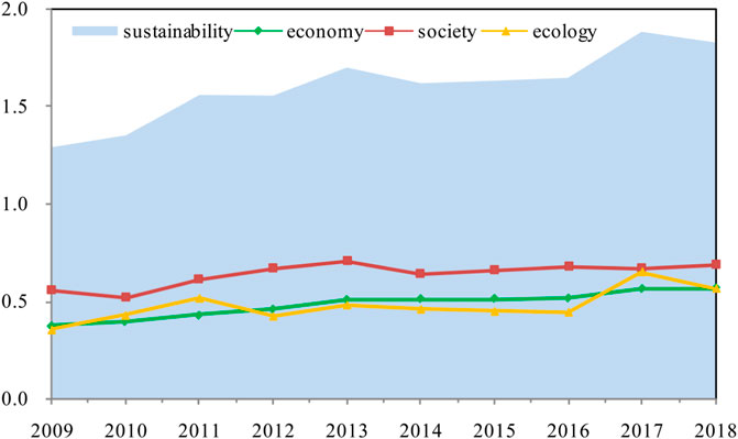
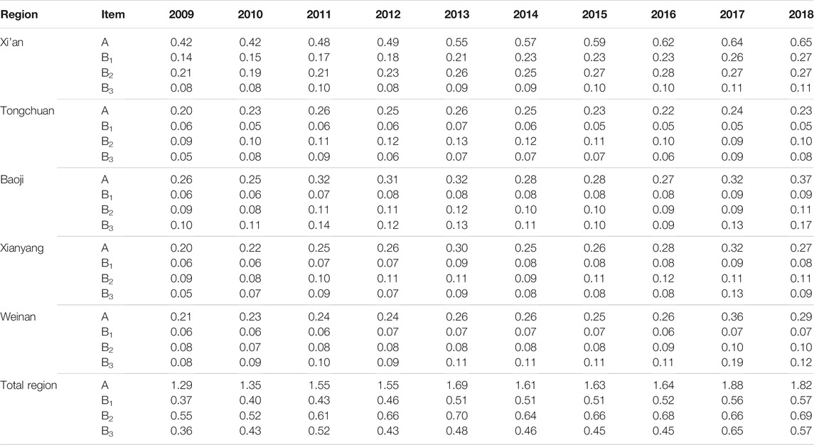
The evaluation levels of sustainable development of WRB in Shaanxi Province rose from 1.29 in 2009 to 1.87 in 2018 with an upward overall trend and a subtle fluctuation (Figure 2 and Table 2). The inflection points were detected between 2013 and 2017, and the values remained around 1.6 from 2014 to 2016.
At the regional scale, the levels of sustainable development in different regions (Table 2 and Figure 3A). The level of sustainable development in Xi’an was much higher than that of the other four cities (Tongchuan, Baoji, Xianyang, and Weinan) from 2009 to 2018. It indicated that the levels of sustainable development of these four cities had different levels of hysteresis, and different regions showed diversified development. The value of Tongchuan was the lowest, hovering between 0.20 and 0.26. The levels of sustainable development in four cities except Tongchuan had seen a yearly increase.
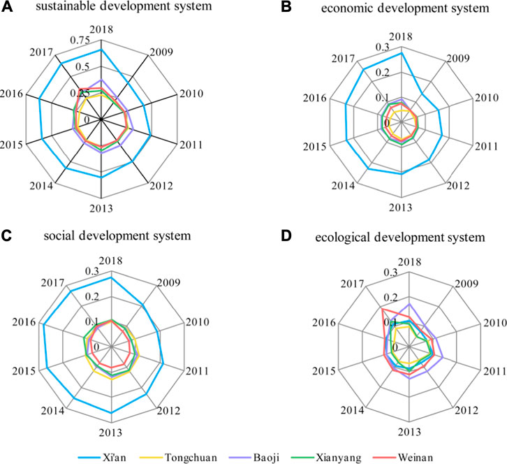
FIGURE 3. The evaluation value of river basin sustainable development by score-radar maps (A) sustainable development, (B) economic development, (C) social development, and (D) ecological development.
The economic development system (B1) and the social development system (B2) were on a similar development track compared with the sustainable development system (A) (Figures 3B,C). In comparison, the value of the ecological development system (B3) was far lower than that of the economic development system (B1) and social development system (B2) (Figure 3D), indicating the lag of ecological development behind local economic and social development. In the economic development system (B1) and the social development system (B2), the values of the four cities (Tongchuan, Baoji, Xianyang, and Weinan) were relatively centralized, with only the value of Xi’an being far ahead than that of the rest (Figure 3A). In the ecological development system (B3), the increased values of Weinan in 2017 and Baoji in 2018 were 0.19 and 0.17, respectively, while the values of the other three cities (Xi’an, Tongchuan, and Xianyang) were relatively stable over the past decade. The level of sustainable development in the ecological system was the lowest, illustrating that the ecological development lagged behind economic and social development in WRB in Shaanxi Province and sustainable development was unbalanced.
Spatial Analysis
Through the change of the spatial distribution for the sustainable development of WRB in Shaanxi Province (Figure 4) and calculation of the relative parameters of standard deviational ellipse (Table 3) from 2009 to 2018, the evolution of spatial pattern was analyzed from four aspects of spatial distribution (center, shape, range, and direction) to account for the dynamic changes of spatial difference.
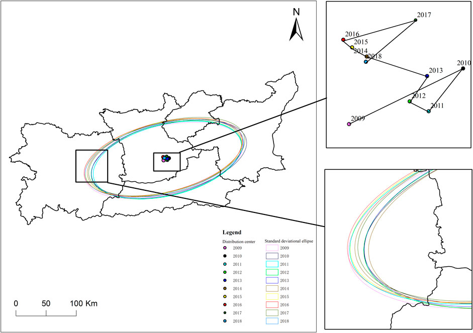
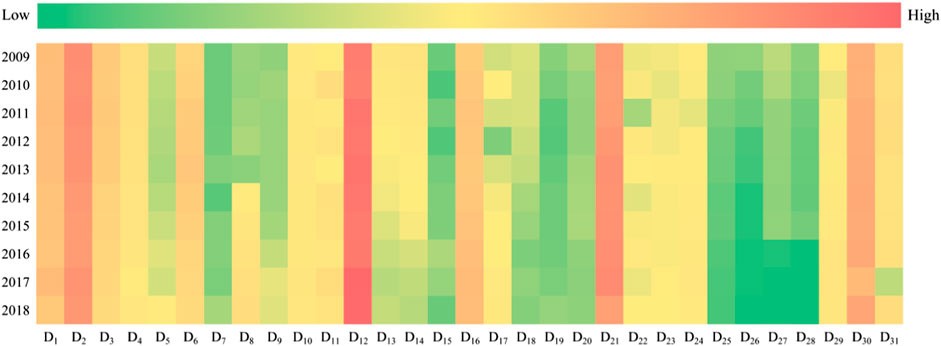
FIGURE 4. The evolution of a spatial distribution pattern on the river basin sustainable development. D1–D31 represent the obstacle degree of the corresponding indicator.
The spatial distribution centers of sustainable development of WRB in Shaanxi Province were adjacent to Xi’an and Xianyang in 2009–2018. Overall, the spatial distribution center shifted to the north, showing that the accelerated growth speed of cities in the northern part of the axis, and the enhanced influence on the overall distribution pattern of the study area. The rotation angle of the standard deviational ellipse of spatial distribution dropped with a small counterclockwise rotation, suggesting that the study area in the northeastern cities were growing faster than the southwestern cities.
From the perspective of a spatial distribution shape, the long axis of the ellipse increased first and then shortened. Such a trend indicated that the spatial distribution shape changed from dispersion to polarization and then to dispersion. The changes in the short axis were the opposite. On the whole, the spatial distribution ellipse showed an obvious flattening trend; that is, the long axis grew and the short axis shrank. Afterward, the flattening trend gradually weakened and the directivity abated.
Obstacle Factor
The obstacle degree of 31 indicators ranked by the obstacle degree model (Table 4 and Figure 5). The biggest obstacle degree was the number of college students per 10,000 (D12). Prior to 2013, the financial revenue (D2) and the amount of water resource per capita (D21) were ranked second and third, respectively. The rankings were reversed from 2013 to 2017, indicating that the influence of economic obstacles on sustainable development of WRB in Shaanxi Province was gradually weakened with the increase of financial revenue. The fourth obstacle indicator was the investment in water conservancy as a percentage of GDP (D30), while the fifth obstacle factors alternated between the gross domestic product (D1) and urban living area per capita (D16).

TABLE 4. Dominant obstacle indicators and the order of obstacle degree on the river basin sustainable development.
Discussion
Extended Implication
The ecological development of WRB in Shaanxi Province fell so far behind economic and social development on the whole during 2009–2018, despite the striking advancement of ecological development that had been made at the later stage of the study. The improvement of ecological development cannot be separated from the management behavior of the government. China attaches great importance to RBSD in the face of environmental degradation and water shortage. In 2014, President Xi Jinping called for a water control policy of “giving priority to saving water, balancing space, systematic treatment, and exerting force all-sided.” From 2016 to 2017, the Shaanxi provincial government issued a series of policies such as the Overall Plan for the Construction of Weihe Ecological Zone in Shaanxi Province and the Implement Plan Comprehensively of River Administrator in Shaanxi Province. Subsequently, a major national strategy of “Ecological conservation and high-quality development of the Yellow River basin” was proposed in 2019. WRB is a typical region with water shortage and underdeveloped economy, and water resources pose an obvious constraint on the sustainable development of WRB in Shaanxi Province. The water resources shortage and ecological environment pollution hamper the sustainable development of the economy and society. Conversely, the long-term development model has only focused on the aspects of economy and society, exerting great pressure on the ecological environment. Thus, solving the contradiction between economic and social development and environmental protection should be considered pivotal to the sustainable development of WRB in Shaanxi Province. The government departments must attach importance to the basin ecological management and water resources conservation for the sake of ensuring sustainable development of WRB in Shaanxi Province.
Among the five cities, Xi’an was identified as the region with the highest level of sustainable development during the study period, while Tongchuan was the lowest. Xi’an has developed into the only megacity in northwest China by virtue of its sound economic-social development foundation and the status as the central city of Shaanxi Province. Xi’an is in a high-speed state of sustainable development; its core leading role constantly enhanced, exerting a siphon effect. Meanwhile, Tongchuan, as a resource–based city in its early development stage, is facing the pressure of resource exhaustion, limited natural conditions, and prominent environmental problems, impeding its sustainable development. The results revealed evident polarization among regions as well as unsynchronized sustainable development. The study area belongs to an important exploitation area of Guanzhong Plain urban agglomeration, having formed a superior economic base in the long-term development. The western development provided favorable conditions for resource-rich regions, which is the main reason for the internal differences in sustainable development among regions. Besides, the implementation of the Belt and Road Initiative has greatly promoted regional coordination and sustainable development.
The results of obstacle degree unexpectedly discovered that the amount of water resource per capita (D21) and the investment in water conservancy as a percentage to GDP (D30) in the ecological development system (B3) were vital factors hindering sustainable development of WRB in Shaanxi Province. The ecological environment, especially water resources, acts as a primary in the river basin sustainable development. Water conservancy construction is regarded as the basic support and important guarantee for promoting economic growth, social progress, and ecological control. In recent years, investment in water conservancy construction and water conservancy projects have seen a continuous increase, especially the construction of the Water Diversion from Hanjiang River to Weihe River basin project (172 major national water conservancy projects of China in 2015 and 10 major water ecological projects of Shaanxi Province in 2017), bringing obvious ecological–economic benefits.
Limitation and Improvement
Indicator Optimization
Including environmental, social, and economic factors, sustainability indicators have been considered as a potential assessment method (Rama et al., 2020). GDP (D1), an important comprehensive statistical indicator in the economic accounting system, is often used to measure the economic status of a country. Its limitation is that it does not involve the ecological environment. Under a rapid social and economic development, GDP cannot fully represent the relationship between human activities and ecological environment, nor can it uncover resource consumption and environmental loss incurred by the economic development. To overcome the above shortcomings, the current system of national economic accounting was reformed based on the sustainable development, with the indicator green GDP (sustainable income) introduced. Green GDP is the calculation of environmental resource elements in a comprehensive environmental–economic accounting system, namely, environmental resource cost and protection services fees are deducted from GDP. Green GDP implicates a harmonious sustainable development model between economic growth and ecological environment, which is conducive to evaluating the effect of economic growth. However, the existing literature is insufficient to answer the question of what is the difference between GDP and green GDP in China (Wu and Han, 2020). Although a traditional indicator (GDP) was used in this article, it does not mean that green GDP is meaningless. In the follow-up work, it can be considered to reasonably adopt the indicator of green GDP in the indicator system of sustainable development and explore the change for RBSD.
Ammonia nitrogen discharge (D27) and chemical oxygen demand discharge (D28) are the indicators of water environmental quality (C8) in the ecological development system (B3); they represent an eutrophication degree and an organic pollutant content in river basin, respectively. According to the Shaanxi Water Resources Bulletin in 2018, the major pollutants exceeding the standard in WRB in Shaanxi Province were ammonia nitrogen, chemical oxygen demand, and total phosphorus. However, the indicator of total phosphorus is not involved in our indicator system due to the lack of data; therefore, it is unclear whether this indicator will lead to the variation on sustainable development of WRB in Shaanxi Province. In addition, the publicly obtained data by the government may need further adjustment according to the actual measured values in the field.
WRB is characterized by severe soil erosion owing to overexploitation, especially in the mining area, highway, railway, and other engineering construction sections. Severe soil and water loss not only threatens the downstream of WRB, but also aggravates the deterioration of the ecological environment. Therefore, given the actual development situation of WRB, the suitable indicators were selected when constructing the indicator system for the sustainable development of WRB in Shaanxi Province. Particularly, the growth rate of soil erosion control (D31) was added to the indicator system. Such an indicator has not been extensively used in sustainable development research but is conducive to the planning and decision-making of basin management. Because the factors affecting RBSD are diversified, whether the indicators in the established indicator system for our study are applicable to other regions remains to be further explored.
Basin Management
Studies in China focusing on water resource management have emphasized the effective utilization of water resources while neglecting the protection of water quality (Cai et al., 2017; Zhou et al., 2015). Few studies have focused on the sustainable development of basin management, especially in arid areas of northwest China.
According to China’s current water law, basin management is combined with the administrative division management. The inevitable consequence is a segmented state, a kind of transition from water resources management to administrative management. Division management hinders overall planning, unified supervision, and rational allocation. Under the restriction of market economy and traditional thoughts, the local government is driven by their respective economic interests, which conflicts with the unified basin management, especially in the exploitation, utilization, and protection of natural resources.
In the practice of RBSD, developed countries such as Australia, the United States, and Germany give importance to the sustainable development, and the coordination of population, resource, and environment, highlighting the long-term management and basin integrity, while taking into account the comprehensive utilization of water resources and engineering measures. Social, ecological, and environmental factors should be reflected in the planning, with the river basin managed as a unit, not as an administrative division. Kotir et al. (2016) investigated the interaction between the population, the water resource, and the agricultural development of the Volta River basin in West Africa, and it could enhance sustainable management within the basin. Wei et al. (2017) describe the evolution of the societal value of water resources in Australia over a period of 169 years and then provide management practices focused on the sustainable water resource use. The theory of RBSD had benefited the development and management practices of river basin ecosystems, such as the Amazon River (Ioris, 2020), the Mississippi River Piazza and La Peyre (2011), the Tennessee River Secchi and Mcdonald (2019), and the Rhine River Jeannot et al. (2018), offering a reference for RBSD in China.
A New Perspective on Sustainability Assessment
The framework of the planetary boundary in 2009 was considered as one of the most symbolic achievements in the field of quantification of international resource and environmental carrying capacity in recent years (Rockström et al., 2009; Running, 2012). The concept first defined the maximum safety threshold of the earth’s ecosystem in a series of environmental problems, such as climate change, water resources consumption, land use, nitrogen and phosphorus cycle, and loss of biodiversity. It is used to judge environmental sustainability as a whole (Steffen et al., 2015). Environmental sustainability can comprehensively reflect the complex effects of human activities on the earth’s ecosystem and provide a policy basis for key fields of environmental governance.
Studies of planetary boundaries have concentrated on global, national, and regional scales (Dao et al., 2018; Huang et al., 2020). Water resource consumption is a compound environmental problem; its influence scope is mainly a river basin. Combining with the planetary boundary framework, the safe interval of water resources utilization and RBSD can be discussed, providing the development space and early warning threshold for regional sustainable development.
Conclusion
This article constructed an indicator system of sustainable development. The entropy method and standard deviational ellipse were used to evaluate temporal and spatial variations for sustainable development of WRB in Shaanxi Province. The obstacle degree model was used to calculate and rank the factors that hindered its sustainable development. First, from the perspective of temporal analysis, the overall rise of sustainable development of WRB in Shaanxi Province is accompanied by regional differences. Economic development is synchronous with the social development, while the ecological development is relatively backward. Second, from the perspective of a spatial pattern evolution, the center of distribution moves north and rotates counterclockwise, the shape variation being dispersion-polarization-dispersion. Lastly, the main obstacle factors affecting the sustainable development of WRB in Shaanxi Province during 2009–2018 include the number of college students per 10,000 (D12), local government revenue (D2), amount of water resource per capita (D21), investment in water conservancy as a percentage to GDP (D30), gross domestic product (D1), and urban living area per capita (D16).
Data Availability Statement
The raw data supporting the conclusions of this article will be made available by the authors, without undue reservation.
Author Contributions
YW: conceptualization, methodology, data curation, investigation, writing-original draft, and writing-review and editing. JS: conceptualization, supervision, validation, project administration, and funding acquisition. XZ: writing-review and editing and validation. HS: writing-review and editing and Validation.
Funding
This study was supported by the Special Funds of the National Natural Science Foundation of China (Grant No.42041004), The Key Research and Development Program of Shaanxi (Grant 2019ZDLSF05-02) and the Hundred Talents Project of the Chinese Academy of Sciences (Grant A315021406).
Conflict of Interest
The authors declare that the research was conducted in the absence of any commercial or financial relationships that could be construed as a potential conflict of interest.
Publisher’s Note
All claims expressed in this article are solely those of the authors and do not necessarily represent those of their affiliated organizations, or those of the publisher, the editors, and the reviewers. Any product that may be evaluated in this article, or claim that may be made by its manufacturer, is not guaranteed or endorsed by the publisher.
References
Brown, M. G., and Quinn, J. E. (2018). Zoning Does Not Improve the Availability of Ecosystem Services in Urban Watersheds. A Case Study from Upstate South Carolina, USA. Ecosystem Serv. 34, 254–265. doi:10.1016/j.ecoser.2018.04.009
Bui, N. T., Kawamura, A., Bui, D. D., Amaguchi, H., Bui, D. D., Truong, N. T., et al. (2019). Groundwater Sustainability Assessment Framework: A Demonstration of Environmental Sustainability index for Hanoi, Vietnam. J. Environ. Manage. 241, 479–487. doi:10.1016/j.jenvman.2019.02.117
Cai, J., Varis, O., and Yin, H. (2017). China's Water Resources Vulnerability: A Spatio-Temporal Analysis during 2003-2013. J. Clean. Prod. 142 (4), 2901–2910. doi:10.1016/j.jclepro.2016.10.180
Chen, J., Mei, Y., and Xiao, W. (2019). Establishment of the Ecological Relationships and Properties of the Lhasa River Basin Water Resources System, China. Sustainable Cities Soc. 47, 101477. doi:10.1016/j.scs.2019.101477
Chen, Y.-p., Fu, B.-j., Zhao, Y., Wang, K.-b., Zhao, M. M., Ma, J.-f., et al. (2020a). Sustainable Development in the Yellow River Basin: Issues and Strategies. J. Clean. Prod. 263, 121223. doi:10.1016/j.jclepro.2020.121223
Chen, Y., Zhu, M., Lu, J., Zhou, Q., and Ma, W. (2020b). Evaluation of Ecological City and Analysis of Obstacle Factors under the Background of High-Quality Development: Taking Cities in the Yellow River Basin as Examples. Ecol. Indicators 118, 106771. doi:10.1016/j.ecolind.2020.106771
Cui, X., Zhao, T., and Wang, J. (2021). Allocation of Carbon Emission Quotas in China's Provincial Power Sector Based on Entropy Method and ZSG-DEA. J. Clean. Prod. 284, 124683. doi:10.1016/j.jclepro.2020.124683
D’Ambrosio, E., Gentile, F., and De Girolamo, A. M. (2020). Assessing the Sustainability in Water Use at the basin Scale through Water Footprint Indicators. J. Clean. Prod. 244, 118847. doi:10.1016/j.jclepro.2019.118847
Dao, H., Peduzzi, P., and Friot, D. (2018). National Environmental Limits and Footprints Based on the Planetary Boundaries Framework: The Case of Switzerland. Glob. Environ. Change 52, 49–57. doi:10.1016/j.gloenvcha.2018.06.005
Deng, W., Song, J., Sun, H., Cheng, D., Zhang, X., Liu, J., et al. (2020). Isolating of Climate and Land Surface Contribution to basin Runoff Variability: A Case Study from the Weihe River Basin, China. Ecol. Eng. 153, 105904. doi:10.1016/j.ecoleng.2020.105904
Du, Q., Zhou, J., Pan, T., and Wu, M. (2019). Relationship of Carbon Emissions and Economic Growth in China's Construction Industry. J. Clean. Prod. 220, 99–109. doi:10.1016/j.jclepro.2019.02.123
Fan, Y. P., and Fang, C. L. (2020). Evolution Process and Obstacle Factors of Ecological Security in Western China, a Case Study of Qinghai Province. Ecol. Indic. 117, 106659. doi:10.1016/j.ecolind.2020.106659
Ferreira, S. C. G., De Lima, A. M. M., and Corrêa, J. A. M. (2020). Indicators of Hydrological Sustainability, Governance and Water Resource Regulation in the Moju River basin (PA) - Eastern Amazonia. J. Environ. Manage. 263, 110354. doi:10.1016/j.jenvman.2020.110354
Fu, J., Zang, C., and Zhang, J. (2020). Economic and Resource and Environmental Carrying Capacity Trade-Off Analysis in the Haihe River basin in China. J. Clean. Prod. 270, 122271. doi:10.1016/j.jclepro.2020.122271
Gao, X., Shen, J., He, W., Sun, F., Zhang, Z., Guo, W., et al. (2019). An Evolutionary Game Analysis of Governments' Decision-Making Behaviors and Factors Influencing Watershed Ecological Compensation in China. J. Environ. Manage. 251, 109592. doi:10.1016/j.jenvman.2019.109592
Huang, L., Feng, Y., Zhang, B., and Hu, W. (2021). Spatio-temporal Characteristics and Obstacle Factors of Cultivated Land Resources Security. Sustainability 13, 8498. doi:10.3390/su13158498
Huang, L. H., Hu, A. H., and Kuo, C.-H. (2020). Planetary Boundary Downscaling for Absolute Environmental Sustainability Assessment - Case Study of Taiwan. Ecol. Indicators 114, 106339. doi:10.1016/j.ecolind.2020.106339
Ioris, A. A. R. (2020). Socioecological Economics of Water Development in the Brazilian Amazon: Elements for a Critical Reflection. Ecol. Econ. 173, 106654. doi:10.1016/j.ecolecon.2020.106654
Jeannot, B., Weill, S., Eschbach, D., Schmitt, L., and Delay, F. (2018). A Low-Dimensional Integrated Subsurface Hydrological Model Coupled with 2-D Overland Flow: Application to a Restored Fluvial Hydrosystem (Upper Rhine River - France). J. Hydrol. 563, 495–509. doi:10.1016/j.jhydrol.2018.06.028
Kotir, J. H., Smith, C., Brown, G., Marshall, N., and Johnstone, R. (2016). A System Dynamics Simulation Model for Sustainable Water Resources Management and Agricultural Development in the Volta River Basin, Ghana. Sci. Total Environ. 573, 444–457. doi:10.1016/j.scitotenv.2016.08.081
Li, J., Zhang, D., and Su, B. (2019a). The Impact of Social Awareness and Lifestyles on Household Carbon Emissions in China. Ecol. Econ. 160, 145–155. doi:10.1016/j.ecolecon.2019.02.020
Li, Q., Wang, W., Jiang, X., Lu, D., Zhang, Y., and Li, J. (2019b). Optimizing the Reuse of Reclaimed Water in Arid Urban Regions: A Case Study in Urumqi, Northwest China. Sustainable Cities Soc. 51, 101702. doi:10.1016/j.scs.2019.101702
Mosaffaie, J., Salehpour Jam, A., Tabatabaei, M. R., and Kousari, M. R. (2021). Trend Assessment of the Watershed Health Based on DPSIR Framework. Land Use Policy 100, 104911. doi:10.1016/j.landusepol.2020.104911
Piazza, B. P., and La Peyre, M. K. (2011). Nekton Community Response to a Large-Scale Mississippi River Discharge: Examining Spatial and Temporal Response to River Management. Estuarine, Coastal Shelf Sci. 91 (3), 379–387. doi:10.1016/j.ecss.2010.11.001
Pluchinotta, I., Pagano, A., Vilcan, T., Ahilan, S., Kapetas, L., Maskrey, S., et al. (2021). A Participatory System Dynamics Model to Investigate Sustainable Urban Water Management in Ebbsfleet Garden City. Sustainable Cities Soc. 67, 102709. doi:10.1016/j.scs.2021.102709
Rama, M., González-García, S., Andrade, E., Moreira, M. T., and Feijoo, G. (2020). Assessing the Sustainability Dimension at Local Scale: Case Study of Spanish Cities. Ecol. Indicators 117, 106687. doi:10.1016/j.ecolind.2020.106687
Rockström, J., Steffen, W., Noone, K., Persson, A., Chapin, F. S., Lambin, E. F., et al. (2009). A Safe Operating Space for Humanity. Nature 461 (7263), 472–475. doi:10.1038/461472a
Roobavannan, M., Kandasamy, J., Pande, S., Vigneswaran, S., and Sivapalan, M. (2020). Sustainability of Agricultural basin Development under Uncertain Future Climate and Economic Conditions: A Socio-Hydrological Analysis. Ecol. Econ. 174, 106665. doi:10.1016/j.ecolecon.2020.106665
Roshan, A., and Kumar, M. (2020). Water End-Use Estimation Can Support the Urban Water Crisis Management: A Critical Review. J. Environ. Manage. 268, 110663. doi:10.1016/j.jenvman.2020.110663
Running, S. W. (2012). A Measurable Planetary Boundary for the Biosphere. Science 337 (6101), 1458–1459. doi:10.1126/science.1227620
Secchi, S., and Mcdonald, M. (2019). The State of Water Quality Strategies in the Mississippi River Basin: Is Cooperative Federalism Working? Sci. Total Environ. 677, 241–249. doi:10.1016/j.scitotenv.2019.04.381
Shaanxi Province Department of Water Resources (2018). Shaanxi Water Resources Bulletin 2018. [2020-5-22]. Available at: http://slt.shaanxi.gov.cn/gb-zxfw-news-3-dfnj-93956. (in Chinese).
Shaanxi Provincial Bureau of Statistics (2019). Shaanxi Statistical Yearbook 2019. Beijing: China Statistics Press. (in Chinese).
Shannon, C. E. (1948). A Mathematical Theory of Communication. Bell Syst. Tech. J. 27 (3), 379–423. doi:10.1002/j.1538-7305.1948.tb01338.x
Shen, Q., and Ma, Y. (2020). Did Water Diversion Projects lead to Sustainable Ecological Restoration in Arid Endorheic Basins? Lessons from Long-Term Changes of Multiple Ecosystem Indicators in the Lower Heihe River Basin. Sci. Total Environ. 701, 134785. doi:10.1016/j.scitotenv.2019.134785
Silva, J. d., Fernandes, V., Limont, M., Dziedzic, M., Andreoli, C. V., and Rauen, W. B. (2020). Water Sustainability Assessment from the Perspective of Sustainable Development Capitals: Conceptual Model and index Based on Literature Review. J. Environ. Manage. 254, 109750. doi:10.1016/j.jenvman.2019.109750
Silva, L. C. C. d., Filho, D. O., Silva, I. R., Pinto, A. C. V. e., and Vaz, P. N. (2019). Water Sustainability Potential in a university Building - Case Study. Sustainable Cities Soc. 47, 101489. doi:10.1016/j.scs.2019.101489
Song, J., Tang, B., Zhang, J., Dou, X., Liu, Q., and Shen, W. (2018). System Dynamics Simulation for Optimal Stream Flow Regulations under Consideration of Coordinated Development of Ecology and Socio-Economy in the Weihe River Basin, China. Ecol. Eng. 124, 51–68. doi:10.1016/j.ecoleng.2018.09.024
Srinivas, R., Singh, A. P., Dhadse, K., Garg, C., and Deshmukh, A. (2018). Sustainable Management of a River basin by Integrating an Improved Fuzzy Based Hybridized SWOT Model and Geo-Statistical Weighted Thematic Overlay Analysis. J. Hydrol. 563, 92–105. doi:10.1016/j.jhydrol.2018.05.059
Steffen, W., Richardson, K., Rockström, J., Cornell, S. E., Fetzer, I., Bennett, E. M., et al. (2015). Planetary Boundaries: Guiding Human Development on a Changing Planet. Science 347 (6223), 1259855. doi:10.1126/science.1259855
Wada, Y., Flörke, M., Hanasaki, N., Eisner, S., Fischer, G., Tramberend, S., et al. (2016). Modeling Global Water Use for the 21st century: the Water Futures and Solutions (WFaS) Initiative and its Approaches. Geosci. Model. Dev. 9, 175–222. doi:10.5194/gmd-9-175-2016
Wang, Q., Li, S., and Li, R. (2019a). Evaluating Water Resource Sustainability in Beijing, China: Combining PSR Model and Matter-Element Extension Method. J. Clean. Prod. 206, 171–179. doi:10.1016/j.jclepro.2018.09.057
Wang, X., Su, P., Lin, Q., Song, J., Sun, H., Cheng, D., et al. (2019b). Distribution, Assessment and Coupling Relationship of Heavy Metals and Macroinvertebrates in Sediments of the Weihe River Basin. Sustainable Cities Soc. 50, 101665. doi:10.1016/j.scs.2019.101665
Wang, Z.-g., Luo, Y.-z., Zhang, M.-h., and Xia, J. (2014). Quantitative Evaluation of Sustainable Development and Eco-Environmental Carrying Capacity in Water-Deficient Regions: A Case Study in the Haihe River Basin, China. J. Integr. Agric. 13 (1), 195–206. doi:10.1016/S2095-3119(13)60423-2
Wei, J., Wei, Y., and Western, A. (2017). Evolution of the Societal Value of Water Resources for Economic Development versus Environmental Sustainability in Australia from 1843 to 2011. Glob. Environ. Change 42, 82–92. doi:10.1016/j.gloenvcha.2016.12.005
Wu, J., Mao, R., Li, M., Xia, J., Song, J., Cheng, D., et al. (2020). Assessment of Aquatic Ecological Health Based on Determination of Biological Community Variability of Fish and Macroinvertebrates in the Weihe River Basin, China. J. Environ. Manage. 267, 110651. doi:10.1016/j.jenvman.2020.110651
Wu, S., and Han, H. (2020). Sectoral Changing Patterns of China's green GDP Considering Climate Change: An Investigation Based on the Economic Input-Output Life Cycle Assessment Model. J. Clean. Prod. 251, 119764. doi:10.1016/j.jclepro.2019.119764
Xu, F., Li, H., and Bao, H. (2018). Performance Comparisons of Land Institution and Land Regulation Systems on Water Area Decrease. Habitat Int. 77, 12–20. doi:10.1016/j.habitatint.2017.12.009
Zhang, K., Shen, J., He, R., Fan, B., and Han, H. (2019). Dynamic Analysis of the Coupling Coordination Relationship between Urbanization and Water Resource Security and its Obstacle Factor. Ijerph 16, 4765. doi:10.3390/ijerph16234765
Zhao, A., Zhu, X., Liu, X., Pan, Y., and Zuo, D. (2016). Impacts of Land Use Change and Climate Variability on green and Blue Water Resources in the Weihe River Basin of Northwest China. Catena 137, 318–327. doi:10.1016/j.catena.2015.09.018
Zhao, D., Li, C., Wang, Q., and Yuan, J. (2020). Comprehensive Evaluation of National Electric Power Development Based on Cloud Model and Entropy Method and TOPSIS: A Case Study in 11 Countries. J. Clean. Prod. 277, 123190. doi:10.1016/j.jclepro.2020.123190
Zhong, S. Z., Yuan, J., Kong, H. N., Liu, B., Tian, X., Chen, W., et al. (2018). Emergy-based Sustainability Evaluation of Erhai Lake Basin in China. J. Clean. Prod. 178, 142–153. doi:10.1016/j.jclepro.2018.01.019
Zhou, Y., Guo, S., Xu, C.-Y., Liu, D., Chen, L., and Wang, D. (2015). Integrated Optimal Allocation Model for Complex Adaptive System of Water Resources Management (II): Case Study. J. Hydrol. 531, 977–991. doi:10.1016/j.jhydrol.2015.10.043
Keywords: sustainable development, the Weihe River basin, entropy method, standard deviational ellipse, obstacle model
Citation: Wang Y, Song J, Zhang X and Sun H (2021) Sustainable Development Evaluation and Its Obstacle Factors of the Weihe River Basin in Shaanxi Province, China. Front. Earth Sci. 9:744224. doi: 10.3389/feart.2021.744224
Received: 20 July 2021; Accepted: 23 August 2021;
Published: 01 October 2021.
Edited by:
Xiaofei Yu, Northeast Normal University, ChinaReviewed by:
Peng Li, Xi'an University of Technology, ChinaGary Feng, National Laboratory for Agriculture and the Environment, Agricultural Research Service (USDA), United States
Copyright © 2021 Wang, Song, Zhang and Sun. This is an open-access article distributed under the terms of the Creative Commons Attribution License (CC BY). The use, distribution or reproduction in other forums is permitted, provided the original author(s) and the copyright owner(s) are credited and that the original publication in this journal is cited, in accordance with accepted academic practice. No use, distribution or reproduction is permitted which does not comply with these terms.
*Correspondence: Jinxi Song, amlueGlzb25nQG53dS5lZHUuY24=
 Yirui Wang
 Jinxi Song
 Xuexian Zhang1,2