 Hongmei Yu
 Wenjian Yang
 Bo Zhao
 Zhengquan Chen
 Bin Zhou3
 Hao Luo
95% of researchers rate our articles as excellent or good
Learn more about the work of our research integrity team to safeguard the quality of each article we publish.
Find out more
ORIGINAL RESEARCH article
Front. Earth Sci. , 18 October 2021
Sec. Volcanology
Volume 9 - 2021 | https://doi.org/10.3389/feart.2021.713444
This article is part of the Research Topic Volcanic Islands - A Challenge for Volcanology View all 11 articles
Weizhou island, located in the north margin of the South China Sea (SCS), is characterized by multi-stage volcanism, several eruption styles and eruption craters, and is also the youngest Quaternary volcanic island in China. An eruption on this island may pose high risk to life and property. However, the eruptive history of Weizhou island, the craters number and location, and their eruptive sequence and characteristics are still being debated, which are important for potential volcanic hazard assessment. In the present study, field surveys, 40Ar/39Ar and 14C geochronological studies and whole rock composition analysis of volcanic rock are used to investigate the eruption sequences associated with Weizhou island and the characteristics of each period. Four volcanoes were discovered at Henglushan, Hengling, Nanwan and Daling. The Henglushan and Hengling volcanoes were produced by early weak explosive and late effusive eruptions, and lavas from these volcanoes represent the foundation of island. Conversely, the Nanwan and Daling volcanoes are linked to multiple explosive eruption phases, with hydromagmatic eruptions in the first and last phase and a magmatic explosive eruption in the second phase. The pyroclastic density currents (PDCs) deposits of the Nanwan and Daling volcanoes virtually cover the entire island. Volcanic activity in Weizhou island started in Early Pleistocene and ended in Late Pleistocene. This can be divided into the following distinct periods: 1,420–1,260, 870–740, 600–480, 283–222 ka, and 33.7–13 ka. The first four periods were dominated by effusive eruptions associated with the Henglushan and Hengling volcanoes, which peaked between 870 and 740 ka. After this period, explosive eruptions began at around 33.7 ka because of magma–water interactions. These explosive eruptions then created the Nanwan and Daling volcanoes. Early effusive lava flows in Weizhou island are characterized by basaltic compositions and are linked with a small amount of fractional crystallization. Magmas in later eruptions contained slightly lower SiO2 and involved some basanite. Fractional crystallization was also less pronounced in these lavas because of their rapid ascent.
The area around Leiqiong (Leizhou Peninsula and Hainan Island) and Beibu Gulf in the north margin of the South China Sea (SCS) was formed during the late expansion stage of the SCS Basin (Figures 1A,B). This region is the largest Quaternary volcanic field in South China and includes Weizhou island in Beibu Gulf (Fan et al., 2006), which is approximately 37 km (20 sea mile) away from Beihai city in Guangxi province (Figure 1B). This island is the youngest Quaternary volcanic islands in China (Li et al., 2005; Huang and Li, 2007), and it covers an area of approximately 25 km2 and reaches a maximum elevation of 79 m asl. The Xieyang island, a small (< 2.0 km2) associated island, is approximately 14 km southeast of Weizhou island. Both islands contain hydromagmatic and ocean erosion features which are exploited for tourism. Consequently, the Weizhou island Volcano National Geopark was established in 2004 to preserve these unique features. Weizhou island hosts almost 20,000 residents and it is visited by thousands of tourists daily, and thus an eruption on the island may pose high risk to life and property.
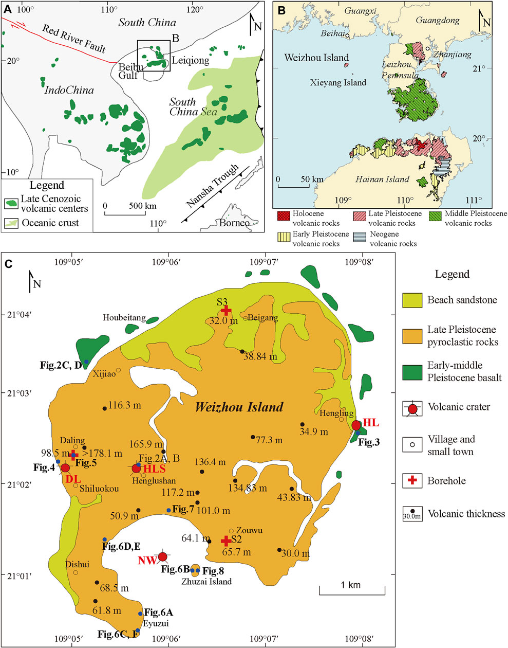
FIGURE 1. (A) Distribution of Late Cenozoic basalts in the SCS and its periphery (Yan et al., 2018). (B) Quaternary volcanic rocks distribution of Leiqiong and the surrounding area of Beibu Gulf, southern China (modified from) (C) Geological map of volcanoes on Weizhou island (modified from Fan et al., 2006; parts of the drilling depths are from Lu, 1993). HLS-Henglushan volcano, HL-Hengling volcano, DL-Daling volcano, NW-Nanwan volcano.
Understanding the history, sequences, and characteristics of eruptions that occurred in Weizhou island is necessary for volcanic hazard assessment. Small oceanic islands are particularly vulnerable to explosive eruptions and the risk is potentially aggravated by their geographical isolation and the weak socioeconomic conditions of local communities (Pimentel et al., 2021). Therefore, detailed studies are needed to widen our understanding of Weizhou island eruptions and their potential impacts.
Weizhou island is characterized by elevated terrain in the south and low-lying terrain in the north. Volcanic rocks in Weizhou island are dominated by alkaline basalts, which exhibit the Dupal isotopic anomaly and geochemical characteristics that are consistent with those of ocean island basalts (OIBs) formed by mixing of the DM and EMII mantle components (Fan et al., 2008; Xu et al., 2012; Yang et al., 2020; Zhang et al., 2020). According to previous studies (Li and Liu, 1991; Lu, 1993; Li and Fang, 2004; Fan et al., 2006), the formation of Weizhou island involved multi-stage volcanism, characterized by several eruption styles, which produced several volcanoes. Rao (1988) suggested the presence of two volcanoes in Weizhou island, with one at sea level, 500 m away from the south of Nanwan, and another in Hengling in the east of the island. Based on the distribution, tectonic characteristics, and topographic features associated with volcanic rocks in Weizhou island, Lu (1993) reported three volcanoes in Henglushan, Nanwan, and Daling. However, Li et al. (2005) proposed that the craters locations are at Henglushan, Nanwan, and Eyuzui (also called Eyushan). Thus, the number, locations, and association between these volcanoes are still being debated.
Based on their characteristics and relationships, volcanic strata in Weizhou island can be partitioned into the following groups: 1) Early Pleistocene Zhanjiang Formation volcano-sedimentary rocks, 2) Middle Pleistocene Maoling Formation flood basalts and pyroclastics, 3) Late Pleistocene Huguangyan Formation basaltic pyroclastics, and 4) Holocene Eyushan Formation flood basalts and pyroclastics (Li and Fang, 2004; Li et al., 2005). Because chronological evidence is generally lacking in previous studies, the assigned volcanic-activity periods in Weizhou island require additional investigation.
In the present study, field surveys, geochronological study and whole rock composition analysis of volcanic rock are used to investigate the eruption sequences associated with Weizhou island and the characteristics of each period, and to reconstruct the eruptive history and evolution of Weizhou island. The findings of the present study provide a scientific basis for eruption forecasting for this island.
The SCS is the largest marginal sea in East Asia. It is in the convergence area of the Indo–Australian, Eurasian, and Pacific plates, which represents the junction between the Pacific and Tethyan Tectonic Domains (Zhou et al., 2008). Expansion of the SCS started at around 32 Ma and lasted until 16 Ma (Briais et al., 1993). Owing to mid-oceanic ridge assimilation processes, expansion basalts (32–16 Ma) are rare around the SCS (Huang et al., 2013; Zeng et al., 2017). Conversely, in the north periphery of the SCS and Indochina region, wide distribution of post-expansion volcanic rocks (<16 Ma) is present (Yan et al., 2014, 2018; Figure 1A). The southeast end of the major right lateral-slip Red River Fault originating from the southeast margin of the Tibetan Plateau traverses the study area, and extends to the north margin of the SCS Basin (Chung et al., 1997; Hao et al., 2001; Yan et al., 2006). According to Jia et al. (2003), basalts in the Beibu Gulf Basin and volcanic rocks of the Red River Fault originate from the same mantle source. The Red River Fault was transformed from a left lateral-slip to a right lateral-slip fault around 5.5 Ma (Leloup et al., 1995; Replumaz et al., 2001; Clift and Sun, 2006; Wang et al., 2016), and this tectonic change likely caused mantle perturbations, which triggered magmatic activities to form Weizhou island (Jia et al., 2003). However, the Hainan mantle plume revealed by geophysical and geochemical data likely influenced Late Cenozoic magmatism in the SCS and its periphery significantly (Montelli et al., 2006; Lei et al., 2009; Yan and Shi, 2007; Yan et al., 2008; Wang et al., 2012; Xia et al., 2016; Kimura et al., 2018).
Based on a comparison of rocks and lithologic characteristics of the Nanwan and Huguangyan volcanoes in Zhanjiang, Guangdong, Liu (1986) indicated that the former likely formed during Pleistocene but the exact period was undetermined. In a study involving boreholes (Bureau of Geology and Mineral Resources of Guangxi, 1985; Li and Liu, 1991; Lu, 1993), the onset of volcanism in Weizhou island is assigned to Early Pleistocene, with distinct evolution in the Early, Middle, and Late Pleistocene. However, because the boreholes did not penetrate igneous rocks, the occurrence of volcanic eruptions prior to the Pleistocene in the island remains undetermined. Based on basalt samples from the intertidal zone in Weizhou island, Long et al. (2004) attributed the earliest volcanic activities in the island to the Neogene or slightly later. Field surveys, volcanic rock characteristics, K–Ar dating, optically stimulated luminescence (OSL) dating of sandstone xenoliths, and mollusk shell 14C dating data were used by Fan et al. (2006) to divide volcanic eruptions in Weizhou island into the following: Early–Late Pleistocene effusive (1.42 Ma–0.49 Ma) and Late Pleistocene hydromagmatic (36–33 ka) styles (Figure 1C). Further, Xu et al., 2020 used electron spin resonance (ESR) to date PDCs deposits and obtained ages between 33 and 13 ka. Based on these data, they suggested that the last volcanic eruption in Weizhou island occurred during the Late Pleistocene.
Field surveys were conducted to determine the locations and number of volcanoes in Weizhou island based on indicators, such as scoria cones, welded agglomerates, welded breccia and volcanic bombs. Profile maps were created by mapping the distribution of ejecta, and these were used to analyze the eruption sequences and characteristics in Weizhou island. According to the volcanic strata, clastic grain size and petrographic characteristics, we have defined the eruption style. The products from each volcano were then systematically sampled. Three drill cores were also acquired from Daling, Zouwu (Figure 1C, S2), and Beigang (S3).
The ages of Weizhou island volcanoes were constrained using the 40Ar/39Ar and 14C geochronological methods.
Eleven basalts and basalts xenoliths from PDCs deposits were selected for the 40Ar/39Ar dating. A cutting machine was used to scrape weathered and potentially contaminated surfaces of the basalts, followed by crushing. Particles with sizes between 180 and 250 μm were then screened, and phenocrysts were removed using a magnetic separator, leaving behind just the matrix. Next, the matrix particles were digested using HCl, HNO3, and HF, followed by drying in an oven at 50°C for 24 h. The dried samples were then screened again to obtain particles with sizes between 180 and 250 μm, and remnants of phenocrysts were removed with the aid of a microscope. Samples were then cleaned using acetone and stored in a glass jar for subsequent analyses. Samples were analyzed by irradiation in a TRIGA reactor and Ar–Ar geochronology using an ARGUS-VI mass spectrometer in Oregon State University (OSU). All ages were calculated using ArArCALC v.2.7.0 software (Koppers, 2002), and uncertainties are reported at the 2σ confidence limits.
Charcoal clasts measuring approximately 5 cm in diameter were encountered at a depth of 175.7 m in the borehole drilled in Daling. Some of these clasts were sent to the BETA Laboratory in Miami, Florida United States for 14C dating, where measurements were performed using a NEC accelerator mass spectrometer and a Thermo Fisher isotope ratio mass spectrometer. The age was calibrated based on the INTCAL13 database on BetaCal3.21 software with 2σ (95% confidence limits). The age in this paper is calendar year obtained from conventional radiocarbon ages.
In the present study, the four volcanoes identified during field surveys are the Henglushan, Hengling, Nanwan, and Daling, and these exhibit distinct eruption characteristics and are associated with different eruption styles.
The Henglushan volcano is a central volcano, and located near Guogailing, Henglushan in the mid-western part of Weizhou island (Figure 1C). Guogailing is a shield-like plateau with a diameter of approximately 1 km and an elevation of 60 m. Welded agglomerates with the pyroclastic size between 2 and 10 cm are present on top of Guogailing, while volcanic bombs approximately 60 cm in diameter are near Guogailing (Figures 2A,B); these are typical features of proximal faces. The Henglushan volcano was formed mainly by effusive central eruptions. Borehole data reveal a maximum basalt thickness of 165 m, and this is characterized by thinning with increasing distance from the volcano (Figure 1C). Lavas from this volcano likely provided the foundation for the formation of Weizhou island. Lava flows in intertidal zones in the southwest and north parts of Weizhou island were mostly derived from eruptions of the Henglushan volcano, with the significant weathering of these spheroidal lava bodies indicating that they originated from ancient volcanic eruptions (Figures 2C,D).
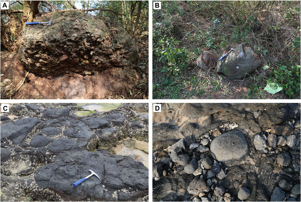
FIGURE 2. Field photographs of volcanic products from Henglushan Volcano. (A) Welded agglomerates on the top of Guogailing at Henglushan. (B) Volcanic bomb with a diameter around 60 cm close to Guogailing. (C) Outcropping lava bodies in Xijiao intertidal zone. (D) Outcropping spheroidal weathered basalts in Xijiao intertidal zone.
Hengling volcano is located near Hengling in the central eastern part of Weizhou island (Figure 1C). Indurated volcanic breccias with size of 0.5–2 cm extending for approximately 100 m are observed at a beach near Hengling. These breccias display banded distribution and contain volcanic bombs with diameters ranging between 10 cm and 1 m (Figures 3A,B), indicating a location near a vent or crater. Although the indurated volcanic breccias are rounded by weathering, breccias with centimetric lengths remain clearly visible (Figures 3C,D). Owing to severe weathering and erosion, distinguishing bombs from spheroidal weathered basalts is difficult. This probably explains the rare mention of a volcano in this location except by Rao (1988) among previous studies. The vent(s) may be eroded or under the sea level. Eruptions associated with the Hengling volcano were also dominantly effusive and the lava can be seen around Hengling volcano.
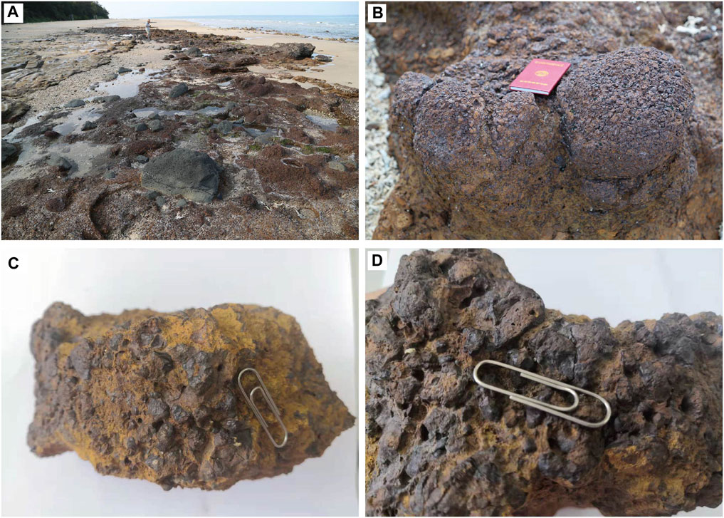
FIGURE 3. Field photographs of Hengling volcano products. (A) Banded volcanic breccias and volcanic bombs inside the breccias. (B) Spheroidal weathered indurated volcanic breccias. (C) Indurated volcanic breccias with weathered matrix. (D) Volcanic breccias with diameter of 0.5–2 cm.
The Daling volcano is in the mid-western part of Weizhou island (Figure 1C), near the shore, and the base of the volcano is at an elevation of 50 m. Welded agglomerates and large volcanic bombs are present in the Shiluokou beach, near Daling (Figure 4A); these features are indicators of a nearby volcano. Lu (1993) used geomorphological features, fault structures, and drill core data to confirm the presence of a volcano in this location. The vent(s) of Daling volcano may also be eroded or under the sea level. In the southwestern shore, thick PDCs deposits (from hydromagmatic eruptions) characterized by numerous cross-bedding, oblique bedding, and U-shaped grooves are present (Figures 4B–D). In addition, palagonitized brown–yellow tephra clasts are observed in the fallout strata produced by magmatic eruption (Figure 4B).
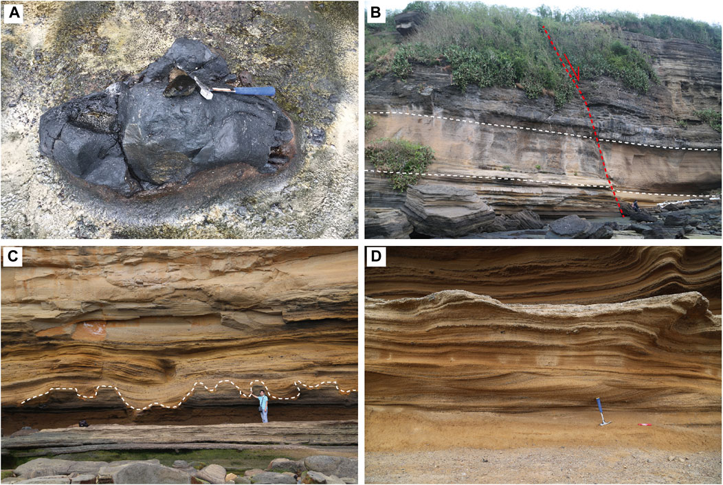
FIGURE 4. Field photographs of Daling volcano deposits. (A) Indurated agglomerates with a baking layer. (B) An approximately 30 m-thick profile of Shiluokou, with PDCs deposits on the top and bottom of the profile and tephra-fall pyroclastics in between. These strata are separated by a normal fault. (C) U-shaped grooves. (D) Cross and oblique beddings in the PDCs strata.
A borehole with depth of 391 m was drilled in Daling and the observed stratigraphy is as follows (Figure 5): Dark red clays are present at between 0 and 33 m depth, followed by pyroclastic layers at between 33 and 132.5 m depth, with yellow/grey–yellow strongly weathered layer at the shallow level and grey/grey–black slightly weathered layer at the deeper level, and soft mudstones, sandstones, and clay below 132.5 m.
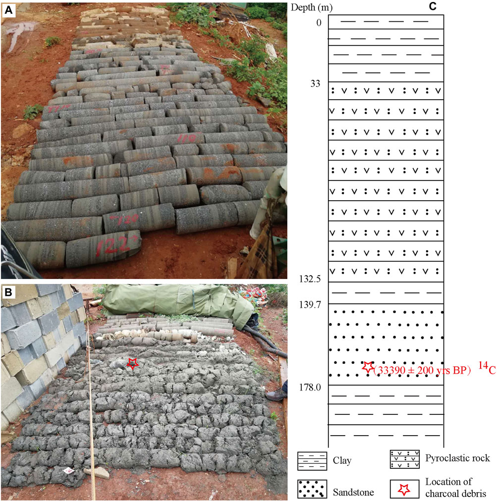
FIGURE 5. Drilled core from Daling. (A) Upper part of the core. (B) Lower part of the core. (C) Stratigraphic column of the Daling borehole.
The Nanwan volcano in the southern part of Weizhou island is almost circular, with a diameter of approximately 2 km, and it represents a maar formed by a hydromagmatic eruption. The south crater wall is missing, probably because of wave erosion or later volcanic activity, whereas well-preserved north, west, and east crater walls appear as vertical cliffs, thereby imparting an armchair-like shape to the volcano. PDCs deposits from the hydromagmatic eruption are distributed around the preserved crater walls. Proximal spatter deposits, such as lava cakes, volcanic bombs and welded volcanic breccias (Figures 6A,B) are also present around the crater walls as well as bean-sized accretionary lapilli (Figure 6C) and bomb sags (Figures 6D,E). Climbing structure was observed in Eyuzui in the south of Nanwan, and the change of the strata inclinations supports that Nanwan is a volcano with several vents (Figure 6F). Considering that the Tianhougong and Zhuzai island profiles in the north and east, respectively, of the Nanwan volcano are the nearest well-preserved stratigraphic profiles, these were analyzed to decipher the eruption sequences of the Nanwan volcano.
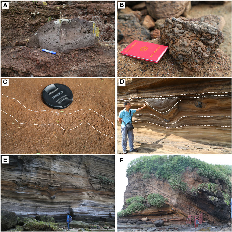
FIGURE 6. Field photographs of Nanwan volcano deposits. (A) Volcanic bomb in brick-red spatter deposits inside the crater walls of Nanwan Volcano. (B) Welded breccias on the eastern side of Zhuzai island. (C) Outcropping accretionary lapilli at the bottom of the PDCs deposits at Eyuzui; Accretionary lapilli are spherical aggregates of volcanic ash, commonly having a concentric structure and formed by clumping of moist ash (Yan et al.,2008; Sigurdsson et al., 2015). (D) Bomb sag structure near Dishui, where volcanic bombs fell into the underlying plastic layer and created cratered surfaces. (E) Thick PDCs deposits and bomb sag structure. (F) Climbing structure at Eyuzui.
The Tianhougong stratigraphic log comprises thick PDCs deposits, scoria, and spatter deposits, with a thickness of approximately 24 m. This stratigraphic log can be separated into the following three layers (Figure 7):
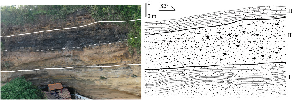
FIGURE 7. Stratigraphic log at Tianhougong.
Layer I: This layer involves yellow PDCs deposits, which consist of quartz, feldspar and a little black scoria. It is consolidated and develops multiple coarse and fine-grained rhythmic characteristic. It has typical base-surge deposits structures, such as cross- and oblique bedding, bomb sag structures. It is approximately 18 m thick.
Layer II: The top part of this layer consists of grey–black scoria and volcanic bombs, and exhibits non-uniform thickness (approximately 2 m on average). The bottom part contains a brown–yellow scoria stratum that is approximately 2 m thick. This layer was formed by an explosive eruption. A palagonitized brown–yellow surface was created by early interactions between hot scoria and water, but this scoria–water interaction significantly decreased later, thereby producing a grey–black scoria stratum.
Layer III: This layer contains 1–2 m thick brown–yellow base-surge deposits, characterized by weathering at the top. The degree of consolidation is weaker than layer I and the content of quartz reduces.
The Zhuzai island stratigraphic log is thinner than the one Tianhougong, with a thickness of 10.2 m (Figure 8). It also comprises PDCs deposits, scoria, and spatter deposits, which also produce three layers.
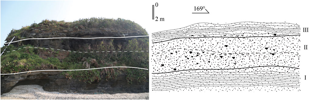
FIGURE 8. Stratigraphic log at Zhuzai island.
Layer I: This 3.5 m thick layer contains PDCs deposits involving cross- and oblique bedding, bomb sags but the bottom part of the layer is unexposed. It is consolidated and develops multiple rhythem.
Layer II: This layer involves proximal faces tephra deposits, with the top 2 m comprising grey–black scoria, volcanic bombs, and lava cakes, while the bottom 2.2 m contain brown–yellow scoria. The scoria is fused together in a plastic state, which formed welded volcanic breccias (Figure 6B).
Layer III: This 2.5 m thick layer contains base-surge deposits characterized by cross-and oblique bedding and weathering at the top.
The layers are consistent with those in the Tianhougong stratigraphic log and indicate that the Nanwan volcano is associated with three phases of activity, with the first and third being hydromagmatic, while the second was magmatic.
The stratigraphy of the S2 borehole (Figure 9A), which extends to a depth of 73.4 m is as follows: Thick grey–yellow and grey–black tuff with bedded and tuff structures are present at 5.0–37.5 m, followed by a thick basalt layer at 37.5–70.7 m, and which is characterized by severe weathering and cracks filled with welded volcanic breccia at 37.5–40 m. In fact, some breccia has been weathered to soil, with widespread joints and fractures at 40.0–43.8 m causing fragmentation of cores at this depth interval. Highly dense grey–black basalts with localized vesicles occur at 43.8–45 m, while the interval at 45.0–62.1 m contains yellow–brown vesicular basalts with localized vesicles. Beneath this layer, dense basalts are present at 62.1–63.5 m, while grey–green basalts with cracks and joints are present at 63.5–67.0 m, and grey–green dense basalts involving joints and cracks are present at 67.0–70.7 m.
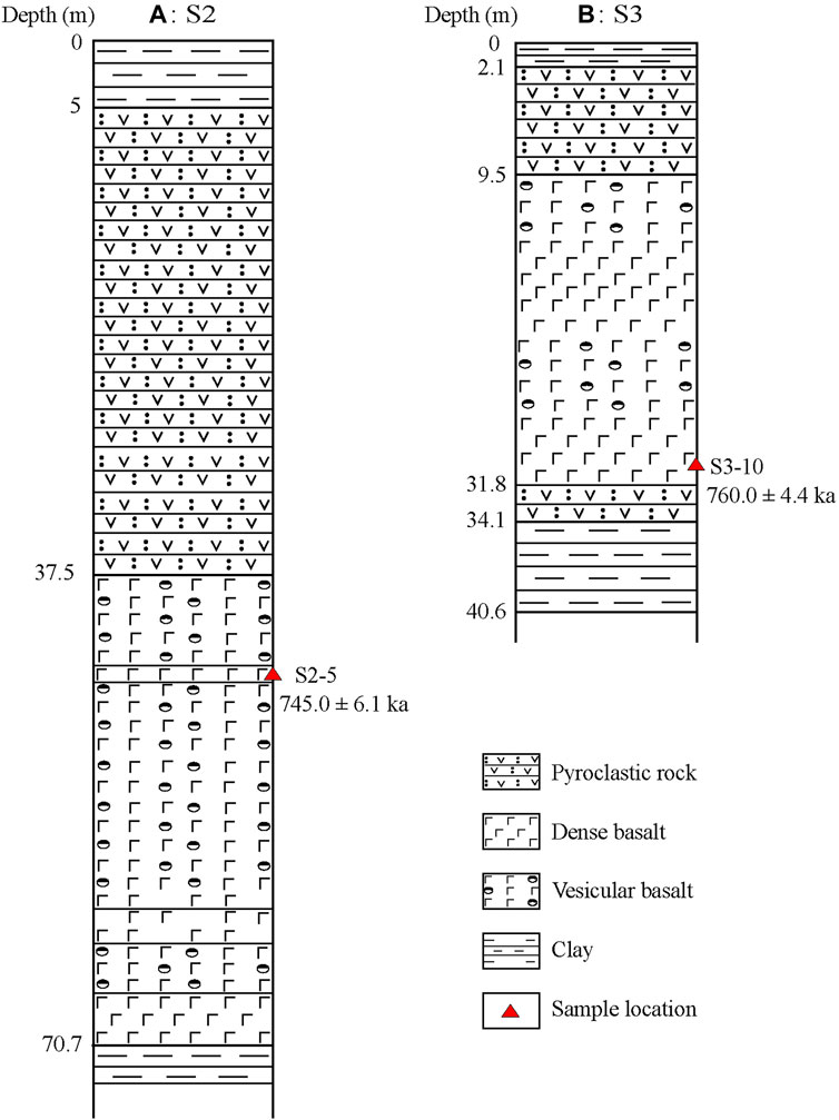
FIGURE 9. Stratigraphic columns boreholes. (A) S2 borehole. (B) S3 borehole.
Borehole S3 (Figure 9B) was drilled to a depth of 66.8 m and it revealed grey–yellow and grey–black tuff at 2.1–9.5 m, while interbedded vesicular basalts approximately 23 m thick occur at 9.5–31.8 m. The interval at 9.5–12.7 m is dominated by grey–black vesicular basalts, while dense block-like basalts dominate at 12.7–22.0 m. In the interval at 22.0–25.5 m, purple–red and yellow–brown vesicular basalts filled with green mudstone are prevalent, whereas at 25.5–31.8 m, grey–black dense block-like basalts predominate, and yellow–grey tuffs and breccias occurring are present at 31.8–34.1 m.
These boreholes reveal that earlier volcanic activities in Weizhou island were mainly associated with effusive eruptions which generated lava flows, whereas later volcanic activities were linked to explosive eruptions which produced pyroclastics. The lavas split into different units during cooling, with the top portion forming vesicular basalts while the bottom portion produced dense basalts.
The basalt 40Ar/39Ar dating data for Weizhou island that were generated in the present study are presented in Table 1. The 40Ar/39Ar ages are in range of 868.5 ± 25.4 ka–222.1 ± 14.3 ka and most are 762.6 ± 7.3–740.5 ± 3.4 ka, which are consistent with the results of previous K-Ar ages (Feng, 1992; Fan et al., 2006). The ages of dense basalt are general 740.5–744.3 ka, but the basalt xenolith ages in pyroclastic rocks are in a wide range. Charcoal clasts collected at a depth of 42 m from a borehole in the Daling volcano yielded a 14C age of 33,390 ± 200 years BP (Figure 5).
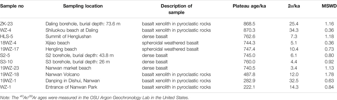
TABLE 1. Weizhou island igneous rock samples that were used for40Ar/39Ar dating and their ages.
Here, we analyze the compositions of lavas in Weizhou island based on whole-rock data reported in previous studies (Li et al., 2005; Fan et al., 2008; Yang et al., 2020). Owing to difficulty to distinguish products from the Henglushan and Hengling volcanoes, and as their eruption periods are comparable, their lavas are simply referred as “Henglushan lava” in the present analysis. The major element measurements of Daling volcano samples are excluded because of significant high ignition loss (Yang et al., 2020). The Henglushan and Nanwan lavas exhibit some compositional differences. Whole-rock SiO2 and Na2 + K2O contents rocks from the Henglushan volcano range between 44.79–50.56 wt% and 3.25–5.45 wt%, respectively, which correspond to trachybasalt and basalt in the total–alkali–silica (TAS) diagram (Figure 10A). Nanwan igneous rocks show overlapping to lower SiO2 contents (41.61–48.67 wt%) and overlapping to higher Na2O + K2O contents (3.75–6.01 wt%), and these fall within the trachybasalt and basanite fields (Figure 10A). Microscopy revealed a basaltic matrix with an intergranular texture and rich in olivine (about 5–10%), pyroxene (<5%), and plagioclase (about 5%) microcrystals (Figure 10B). In contrast, the basanite matrix is vitreous and pitch black under crossed polarized light, and it contains few microcrystals (Figure 10C). Earlier lavas likely experienced fractional crystallization (Yang et al., 2020), but the impact was significantly diminished in later lavas because of the rapid rising and ejection.
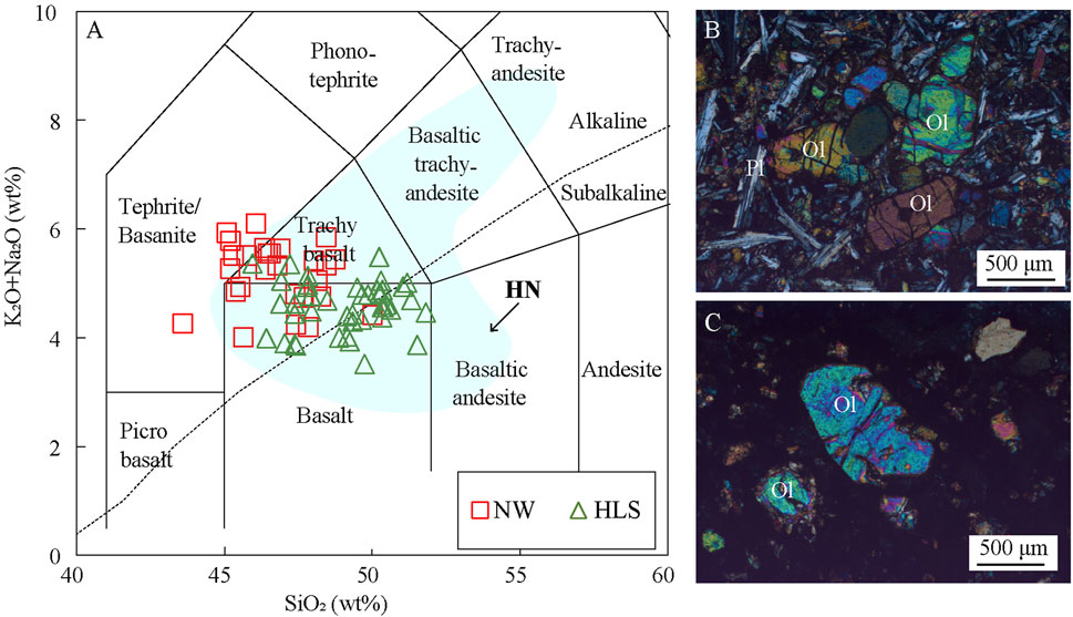
FIGURE 10. (A) TAS diagram of Weizhou volcanic rocks. Classification boundaries are from Le Maitre et al., 1989. Weizhou island data are from (Li et al., 2005; Fan et al., 2008; Yang et al., 2020); The compositions of Hainan (HN) island volcanic rocks are from Ho et al. (2000), Zou and Fan (2010), Wang et al. (2012) and Liu et al. (2015). NW- Nanwan volcano, HLS-Henglushan volcano, HN-Hainan island volcano. (B) Photomicrographs of basalts in Weizhou island, crossed polarized light. (C) Photomicrographs of basanite in Weizhou island, crossed polarized light, Ol-olivine, Pl-plagioclase.
Chondrite-normalized rare earth element (REE) diagrams show that data for samples from the Nanwan and Henglushan volcanoes coincide and exhibit light REEs enrichment; the rocks display no significant Eu anomaly (Figure 11A). The Henglushan basalts show slightly lower total REE (∑REE) and (La/Yb)N values compared to the Nanwan volcano rocks, which suggest primitive magmas of the later were associated with higher partial melting. In the primitive mantle-normalized trace element spider diagram, data for rocks in the region display significant positive Nb–Ta anomalies and negative Pb anomalies, with the later quite prominent in data from the Henglushan basalts (Figure 11B). These characteristics are consistent with OIBs devoid of crustal magma contamination.
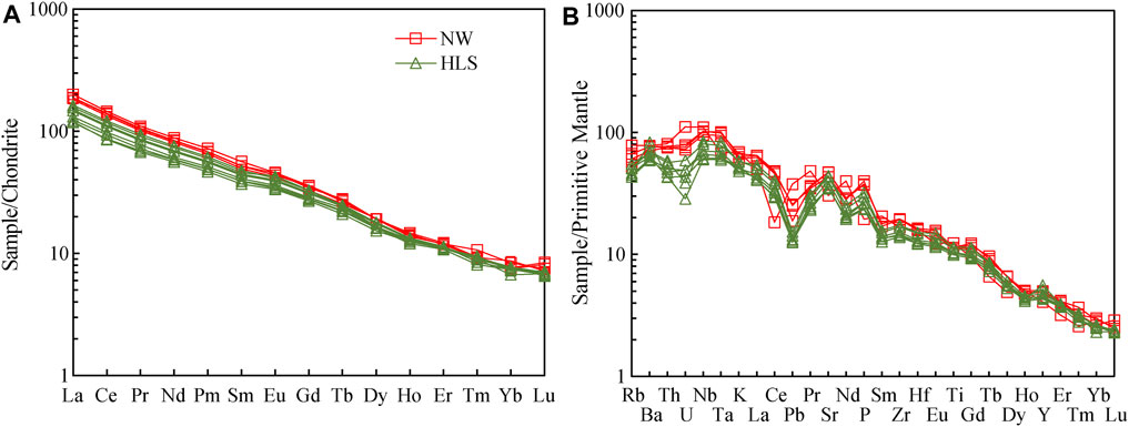
FIGURE 11. Distribution of rare earth (A) and trace element contents (B) in Weizhou volcanic rocks. Chondrite standard value and original mantle standard value data are from Sun and McDonough (1989). Rare earth and trace data of volcanic rocks from (Yang et al., 2020).
The welded agglomerate, volcanic bombs at the top of Guogailing and large areas of lava indicating the eruption styles of Henglushan were early weak explosive and late effusive eruptions. Based on the borehole data, the thickest igneous rocks deposits in the island are in Henglushan, and thinning with increasing distance away (Figure 1C). Therefore, the earliest lavas in Weizhou island probably originate from the Henglushan volcano. The average 40Ar/39Ar age of dense basalts near the Henglushan volcano is 762.6 ± 7.3 ka, while that for lavas in the intertidal zone near Xijiao (western shore) is 744.3 ± 5.1 ka, and these ages are consistent with K–Ar ages (0.79–0.60 Ma) measured by Fan et al. (2006) for the Guogailing basalts. 40Ar/39Ar ages of basalt samples from a depth of 43.8 in Borehole S2 and 26 m in Borehole S3 are 745.0 ± 6.1 ka and 760.0 ± 4.4 ka, respectively. Therefore, these samples are most likely volcanic products belonging to contemporaneous volcanic activities in the island. Although Lu (1993) reported thick basalts in a borehole near Daling, the borehole drilled in Daling in the present study revealed only pyroclastics. Considering the proximity of Daling to Henglushan, the lavas which solidified near Daling likely flowed from the Henglushan volcano. Fan et al. (2006) measured a K–Ar age of 1.42 ± 0.12 Ma using basalt xenoliths from clasts in Shiluokou, Daling; these products are likely from the earliest eruption in Henglushan. Since the 40Ar/39Ar ages of basalt xenoliths from the Daling borehole (depth of 73.6 m) and Shiluokou clasts are 868.5 ± 25.4 ka and 870.3 ± 34.3 ka, these were probably formed after eruption of the Henglushan volcano. Since eruptions in the Nanwan volcano were explosive and the lava thicknesses in the Nanwan borehole are consistent with effusive lava flows from the Henglushan volcano, the basalt xenoliths in the Nanwan pyroclastics may also originate from the Henglushan volcano. 40Ar/39Ar ages of these basalt xenoliths represent eruptions in the Henglushan volcano during different periods. Hence, the Henglushan volcano is linked to multiple effusive eruptions, and the earliest and latest eruptions likely occurred at around 1.42 ± 0.12 Ma and 222.1 ± 14.3 ka, respectively. The most voluminous among these eruptions occurred between 870 and 740 ka.
The products of Hengling volcano are similar to Henglushan volcano, and the eruption styles were also early weak explosive and late effusive eruptions. Although proximal features are present in Hengling, the distribution range of lava flows generated by this volcano still requires accurate determination. Owing to its proximity to the shore, some of its lavas are probably on the seafloor. The 40Ar/39Ar age of the dense lavas that were sampled in this location is 747.4 ± 10.4 ka; this age is comparable to that obtained for the most voluminous eruption in the Henglushan volcano. Therefore, intense volcanic activity occurred in Weizhou island between 870 and 740 ka, and two active volcanoes were present in the island during this period.
Data from the Daling borehole reveal that the two hydromagmatic and one magmatic explosive eruption occurred at the Daling volcano. Pyroclastics produced in these eruptions are mainly in the southwest of the island. Considering that pyroclastics in the Daling borehole are almost 100 m thick (Figure 1C), the volcano is probably linked to major eruptions. However, most of the ejecta may be covered the sea because of its proximity to the coast. According to 14C dating on charcoal clasts beneath the pyroclastics, the Daling volcano eruptions were younger than 33 ka.
The Nanwan volcano involved major eruptions associated with multiple phases, and the pyroclastics from this volcano are found throughout Weizhou island. Eruptions that occurred in the initial period of activity were hydromagmatic and these produced mainly PDCs deposits. The period that followed was dominated by magmatic explosive eruptions and these formed mainly scoria and spatter deposits. In the late -period, eruptions were hydromagmatic, and these also produced mainly PDCs deposits. Fan et al. (2006) reported OSL ages of 33.7 ± 1.8 ka and 33.7 ± 0.4 ka from sandstone xenoliths embedded in the Nanwan pyroclastics, while Xu et al. (2020) dated ejecta samples from deposits in Nanwan using ESR and reported ages between 33 and 13 ka. Therefore, the latest eruption in the Nanwan volcano occurred during the Late Pleistocene, and this is the most recent eruption in Weizhou island. It’s necessary to note that the assignment of a Holocene age to the Nanwan Volcano based on its unconformable presence on the Eyuzui in Nanwan by Li and Wang (2004) and Li et al. (2005) is erroneous. More chronological evidence is needed to determine whether Nanwan is a Holocene volcano.
According to the dating data (Figure 12), volcanic activities in Weizhou island can be divided into 5 periods. The first four periods were dominated by effusive eruptions, while the eruptions in the last period were predominantly explosive. Period I occurred during the Early Pleistocene (1,420–1,260 ka) and it was characterized by minor eruptions, with the lavas limited to the east and west shores of the island. Period II occurred during the Early to Middle Pleistocene (870–740 ka) and it involved major eruptions, which produced lavas exposed throughout the island. In Period III, which occurred during the Middle Pleistocene (600–480 ka), eruptions were relatively minor and localized, and the associated lavas outcrop near Henglushan and Hengling, while basalt xenoliths in the Nanwan pyroclastics also contain products from this period. Period IV is attributed to the Middle to Late Pleistocene (283–222 ka), which was characterized by minor eruptions which produced deposits that are restricted to xenoliths in the Nanwan pyroclastics, without major lava flow. Period V is assigned to the Late Pleistocene (33.7–13 ka), and the associated eruptions produced the Nanwan and Daling volcanoes.

FIGURE 12. (A) Ages of Weizhou island igneous rocks. (B) A statistical graphic of the dating data. K-Ar ages are from Fan et al. (2006) and Feng (1992), OSL ages are from Fan et al. (2006), ESR ages are from Xu et al. (2020). Legends are same as Figure 1C.
Period V coincides with the Last Glacial Maximum, during which sea level was low (Harrison et al., 2019). Therefore, Weizhou island probably subsided after the eruptions that occurred 220,000 years ago, which transformed the area of the island into a coastal or shallow water marine environment. Around 30,000 years ago, explosive eruptions occurred when rising magmas encountered the seawater. However, because sea level rose after the end of the last glacial period, most of the ejecta from these eruptions are presently under the sea.
There are a small volcano called Xieyang island and a large volcanic field in the northern Hainan island surrounding Weizhou island volcano. Similar to Weizhou island, the lower part of Xieyang island volcano is basaltic rocks and the upper part of the island is the PDCs deposits. Fan et al. (2006) tested the K-Ar age of the basalt in the lower part is 0.57 ± 0.05 Ma and the 14C age of the shell in the upper PDCs deposits is 36,135 ± 185 years BP.
A large area of volcanic rocks is distributed in northern Hainan island (Figure 1B), and the volcanic rocks are mainly basalt with a small amount of intermediate rocks (Figure 10A). The eruptive period is divided into six stages (Fan et al., 2004): Miocene stage (5.43–3.04 Ma), Pliocene stage (3.82–3.68 Ma), Early Pleistocene stage (2.11–0.77 Ma), Middle Pleistocene stage (0.73–0.21 Ma), Late Pleistocene stage (0.11–0.06 Ma), Holocene stage (∼0.01 Ma). In the late Pleistocene, a large number of low level craters and base-surge deposits produced by hydromagmatic eruptions were developed (Bai et al., 2003; Sun et al., 2003). We can see from the comparison that the eruption time and eruption styles Qieyang island volcano and northern Hainan Island volcano in Pleistocene correspond well with those of Weizhou island volcano.
The above study shows that there are effusive and explosive eruptions on Weizhou island volcano, and a future eruption could strongly impact the island, with devastating and long-term socio-economic consequences for its 20,000 inhabitants. The extent of the lava flows suggests that effusive eruption can also affect the entire island. Explosive eruptions include hydromagmatic eruptions and magmatic eruptions. The range of base-surge deposits produced by hydromagmatic eruptions can be several times the diameter of the crater (Crowe and Fisher, 1973; Fisher and Schmincke, 1984), so a hydromagmatic eruption may also radiate the entire Weizhou Island (5–6 km long from north to south). The magma explosive eruption produced airborne accumulation in the vicinity of Daling with a thickness of about 4–5 m, indicating a large eruption scale. The possibility of other similar eruptions in the future cannot be ruled out. Although the current data cannot determine the eruption column and volume of the magmatic eruption, the eruption column produced by the magma explosive eruption can spread to a far area under the action of wind. According to numerical simulations, if there is an explosive eruption in Weizhou island involving volcanic ash reaching a height of 23 km, the ash will spread to Hainan, Guangxi, and Guangdong, China under SSW or NNW wind direction (Ma et al., 2008). Despite the relatively low probability of such an event, this worst-case scenario should be considered by regional and national authorities in risk management plans.
Four volcanoes were discovered at Henglushan, Hengling, Nanwan and Daling in Weizhou island. The Henglushan and Hengling volcanoes were produced predominantly by early weak explosive and late effusive eruptions, and these lavas represent the foundation of Weizhou island. Conversely, the Nanwan and Daling volcanoes are linked to multiple eruption phases, with hydromagmatic eruptions in the first and last phase and a magmatic explosive eruption in the second phase. The PDCs deposits of the Nanwan and Daling volcanoes virtually cover the entire Weizhou island.
Volcanic activity in Weizhou island can be divided into the following distinct periods: 1,420–1,260, 870–740, 600–480, 283–222, and 33.7–13 ka. The first four periods were dominated by effusive eruptions associated with the Henglushan and Hengling volcanoes. After this period, explosive eruptions began at around 33.7 ka because of magma–water interactions. These explosive eruptions then created the Nanwan and Daling volcanoes. Sea level rose after the end of the last glacial period, which resulted in that most of the products from these eruptions are presently under the sea.
Early effusive lava flows in Weizhou island are characterized by basaltic compositions and are linked with a small amount of fractional crystallization. Magmas in later eruptions contained slightly lower SiO2 and involved some basanite. Fractional crystallization was also less pronounced in these lavas because of their rapid ascent.
The original contributions presented in the study are included in the article/Supplementary Materials, further inquiries can be directed to the corresponding author.
Written informed consent was obtained from the relevant individuals for the publication of any potentially identifiable images or data included in this article.
HY and BoZ: designing work plan. WY and HL: Pre-processing of chronological tests and whole-rock analysis. ZC, BiZ and GN: field geological survey and sampling. All authors contributed to interpretation and discussion of the results.
This work is supported by the National Nonprofit Fundamental Research Grant of China, Institute of Geology, China Earthquake Administration (Grant No: IGCEA1712).
The authors declare that the research was conducted in the absence of any commercial or financial relationships that could be construed as a potential conflict of interest.
All claims expressed in this article are solely those of the authors and do not necessarily represent those of their affiliated organizations, or those of the publisher, the editors and the reviewers. Any product that may be evaluated in this article, or claim that may be made by its manufacturer, is not guaranteed or endorsed by the publisher.
Thanks to Guangxi Beihai Hydrological Engineering Mineral Geological Survey Institute for providing S2 and S3 drilling data and core samples. We would like to thank Editage (www.editage.cn) for English language editing.
Bai, Z. D., Xu, D. B., Wei, H. Q., and Hu, J. C. (2003). Division of the Active Period of Quaternary Volcanism Maanling, Northern Hainan Province. Seismology Geology. 25 (Suppl. l), 12–20. (in Chinese with English abstract). doi:10.1023/a:1026276925649
Briais, A., Patriat, P., and Tapponnier, P. (1993). Updated Interpretation of Magnetic Anomalies and Seafloor Spreading Stages in the South China Sea: Implications for the Tertiary Tectonics of Southeast Asia. J. Geophys. Res. 98 (B4), 6299–6328. doi:10.1029/92JB02280
Bureau of Geology and Mineral Resources of Guangxi (1985). Regional Geology of Guangxi Zhuang Nationality Autonomous Region. Beijing: Geological Publishing House. (in Chinese).
Chung, S. L., Cheng, H., Jahn, B. M., O’Reilly, S. Y., and Zhu, B. (1997). Major and Trace Element, and Sr-Nd Isotope Constraints on the Origin of Paleogene Volcanism in South China Prior to the South China Sea Opening. Lithos 40 (2-4), 203–220. doi:10.1016/S0024-4937(97)00028-5
Clift, P. D., and Sun, Z. (2006). The Sedimentary and Tectonic Evolution of the Yinggehai-Song Hong basin and the Southern Hainan Margin, South China Sea: Implications for Tibetan Uplift and Monsoon Intensification. J. Geophys. Res. 111 (B6), a–n. doi:10.1029/2005JB004048
Crowe, B. M., and Fisher, R. V. (1973). Sedimentary Structures in Base-Surge Deposits with Special Reference to Cross-Bedding, Ubehebe Craters, Death Valley, California. Geol. Soc. America Bull. 84, 663–682. doi:10.1130/0016-7606(1973)84<663:ssibdw>2.0.co;2
Fan, Q. C., Sun, Q., Li, N., and Sui, J. L. (2004). Periods of Volcanic Activity and Magma Evolution of Holocene in North Hainan Island. Acta Petrologica Sinica 2093, 533–544. (in Chinese with English abstract). doi:10.1016/j.sedego.2004.01.009
Fan, Q. C., Sun, Q., Long, A. M., Yin, K. J., Sui, J. L., Li, N., et al. (2006). Geology and Eruption History of Volcanoes in Weizhou Island and Xieyang Island, Northern Bay. Acta Petrologica Sinica 22 (6), 1529–1537. (in Chinese with English abstract). doi:10.1016/j.sedgeo.2006.03.014
Fan, Q. C., Sun, Q., Sui, J. L., and Li, N. (2008). Trace Element and Isotopic Geochemistry of Volcanic Rocks and It's Techtonic Implications in Weizhou Island and Xieyang Island, Northern Bay. Acta Petrologica Sinica 24 (6), 1323–1332. (in Chinese with English abstract).
Feng, G. R. (1992). Basic Characteristics and Relationship to Tectonic Environment of the Late Cenozoic Basalts along the Coast of South China Sea. Supplement to the Journal of Sunyatsen University, 1, 93–103. (in Chinese with English abstract).
Hao, F., Li, S. T., Gong, Z. H., and Yang, J. M. (2001). Development Mechanism of Diapir and Episodic Fluid Charge in Yingge basin. Sci. China (Series D) 31, 471–476. (in Chinese)10.1007/BF02879792.
Harrison, S., Smith, D. E., and Glasser, N. F. (2019). Late Quaternary Meltwater Pulses and Sea Level Change. J. Quat. Sci. 34 (1), 1–15. doi:10.1002/jqs.3070
Ho, K. S., Chen, J. C., and Juang, W. S. (2000). Geochronology and Geochemistry of Late Cenozoic Basalts from the Leiqiong Area, Southern China. J. Asian Earth Sci. 18, 307–324. doi:10.1016/S1367-9120(99)00059-0
Huang, L. P., and Li, C. N. (2007). Peridotite Xenolith Fragments from Late Quaternary Pyroclastic Flow in Weizhou Island, Beihai, Guangxi. Acta Petrologica et Mineralogica 26 (4), 321–328. (in Chinese with English abstract).
Huang, X. L., Niu, Y., Xu, Y. G., Ma, J. L., Qiu, H. N., and Zhong, J. W. (2013). Geochronology and Geochemistry of Cenozoic Basalts from Eastern Guangdong, SE China: Constraints on the Lithosphere Evolution beneath the Northern Margin of the South China Sea. Contrib. Mineral. Petrol. 165 (3), 437–455. doi:10.1007/s00410-012-0816-7
Jia, D. C., Qiu, X. L., Hu, R. Z., and Lu, Y. (2003). Geochemical Nature of Mantle Reservoirs and Tectonic Setting of Basalts in Beibu Gulf and its Adjacent Region. J. Trop. Oceanography 22 (2), 30–39. (in Chinese with English abstract)
JianDong, X., Yu, H. M., HongMei, Y., Bo, Z., JianPing, L., FeiXiang, W., et al. (2020). The Chronology of Last Eruption of Weizhou Island Volcano in Northern Bay of Guangxi Province. Acta Petrologica Sinica 36 (7), 2111–2115. (in Chinese with English abstract)doi:10.18654/1000-0569/2020.07.12
Kimura, J.-I., Sakuyama, T., Miyazaki, T., Vaglarov, B. S., Fukao, Y., and Stern, R. J. (2018). Plume-stagnant Slab-Lithosphere Interactions: Origin of the Late Cenozoic Intra-plate Basalts on the East Eurasia Margin. Lithos 300-301, 227–249. doi:10.1016/j.lithos.2017.12.003
Koppers, A. A. P. (2002). ArArCALC-software for 40Ar/39Ar Age Calculations. Comput. Geosciences 28, 605–619. doi:10.1016/S0098-3004(01)00095-4
Le Maitre, R. W., Streckeisen, A., Zanettin, B., Le Bas, M. J., Bonin, B., Bateman, P., et al. (Editors) (1989). Igneous Rocks: A Classification of Igneous Rocks and Glossary of Terms (Oxford: Blackwell), 193.
Lei, J., Zhao, D., Steinberger, B., Wu, B., Shen, F., and Li, Z. (2009). New Seismic Constraints on the Upper Mantle Structure of the Hainan Plume. Phys. Earth Planet. Interiors 173 (1-2), 33–50. doi:10.1016/j.pepi.2008.10.013
Leloup, P. H., Lacassin, R., Tapponnier, P., Schärer, U., Zhong, D., Liu, X., et al. (1995). The Ailao Shan-Red River Shear Zone (Yunnan, China), Tertiary Transform Boundary of Indochina. Tectonophysics 251 (1-4), 3–10. doi:10.1016/0040-1951(95)00070-4
Li, C. N., and Wang, F. Z. (2004). Holocene Volcanic Effusion in Weizhou Island and its Geological Significance. J. Mineralogy Petrology 24 (4), 28–34. (in Chinese with English abstract).
Li, C. N., Wang, F. Z., and Zhong, C. S. (2005). Geochemistry of Quaternary Basaltic Volcanic Rocks of Weizhou Island in Beihai City of Guangxi and a Discussion on Characteristics of Their Source. Acta Petrologica et Mineralogica 24 (1), 1–11. (in Chinese with English abstract).
Li, X. M., and Liu, C. Z. (1991). Preliminary Study on the Petrological Characteristics of Alkali-Basalts in Weizhou Island, Guangxi. Geology. Guangxi 4 (1), 43–51. (in Chinese with English abstract).
Liu, C. Z. (1986). Geological and Geomorphological Characteristics of the Crater in south bay of Weizhou Island. Geology. Guangxi 1, 57–64. (in Chinese with English abstract).
Liu, J. Q., Ren, Z. Y., Nichols, A. R. L., Song, M. S., Qian, S. P., Zhang, Y., et al. (2015). Petrogenesis of Late Cenozoic Basalts from North Hainan Island: Constraints from Melt Inclusions and Their Host Olivines. Geochimica et Cosmochimica Acta 152, 89–121. doi:10.1016/j.gca.2014.12.023
Long, A. M., Fan, Q. C., Sun, Q., Yin, K. J., Li, N., and Wang, T. H. (2004). Volcano Eruption Features in Weishou Island of Guangxi. South China J. Seismology 24 (2), 22–27. (in Chinese with English abstract).
Lu, J. L. (1993). The Characteristics of Volcanic Eruption in Weizhou Island, Beihai City, Guangxi. Guangxi Geology. 6 (3), 53–58. (in Chinese with English abstract).
Ma, B. J., Zhao, Y., and Fan, Q. C. (2008). Numerical Simulation on the Airborne Ash of the Weizhou Island Volcanic Activity. Seismological Res. Northeast China 24 (1), 71–80. (in Chinese with English abstract).
Montelli, R., Nolet, G., Dahlen, F. A., and Masters, G. (2006). A Catalogue of Deep Mantle Plumes: New Results from Finite-Frequency Tomography. Geochem. Geophys. Geosyst. 7(11), a-n. doi:10.1029/2006GC001248
Pimentel, A., Self, S., Pacheco, J. M., Jeffery, A. J., and Gertisser, R. (2021). Eruption Style, Emplacement Dynamics and Geometry of Peralkaline Ignimbrites: Insights from the Lajes-Angra Ignimbrite Formation, Terceira Island, Azores. Front. Earth Sci. 9, 673686. doi:10.3389/feart.2021.673686
Replumaz, A., Lacassin, R., Tapponnier, P., and Leloup, P. H. (2001). Large River Offsets and Plio-Quaternary Dextral Slip Rate on the Red River Fault (Yunnan, China). J. Geophys. Res. 106 (B1), 819–836. doi:10.1029/2000JB900135
Sigurdsson, H., Houghton, B., and Mcnutt, S. (2015). The Encyclopedia of Volcanoes. Second Edition. Academic Pressdoi:10.1016/C2015-0-00175-7
Subba Rao, M. V., and Rao, V. D. (1988). Chemical Constraints on the Origin of the Charnockites in the Eastern Ghat mobile belt, India. Chem. Geology. 69, 37–48. (in Chinese). doi:10.1016/0009-2541(88)90156-8
Sun, Q., Fan, Q. C., Wei, H. Q., Sui, J. L., Bai, Z. D., Xu, D. B., et al. (2003). Preliminary Study on Late Pleistocene Phreatomagmatic Eruption of Northern Hainan Island. Seismology Geology. 25 (2), 289–297. (in Chinese with English abstract).
Sun, S.-s., and McDonough, W. F. (1989). Chemical and Isotopic Systematics of Oceanic Basalts: Implications for Mantle Composition and Processes. Geol. Soc. Lond. Spec. Publications 42 (1), 313–345. doi:10.1144/GSL.SP.1989.042.01.19
Wang, D., Wu, S., Li, C., and Yao, G. (2016). Submarine Slide Evidence for Late Miocene Strike-Slip Reversal of the Red River Fault. Sci. China Earth Sci. 59 (11), 2231–2239. doi:10.1007/s11430-015-5534-9
Wang, X. C., Li, Z. X., Li, X. H., Li, J., Liu, Y., Liu, Y., et al. (2012). Temperature, Pressure, and Composition of the Mantle Source Region of Late Cenozoic Basalts in Hainan Island, SE Asia: a Consequence of a Young Thermal Mantle Plume Close to Subduction Zones?. J. Petrology 53 (1), 177–233. doi:10.1093/petrology/egr061
WenJian, Y., Yu, H. M.*, HongMei, Y., Bo, Z., ZhengQuan, C., and Xiang, B. (2020). Mantle Sources and Magma Genesis of Late Cenozoic Basalts in Weizhou Island, Guangxi, China. Acta Petrologica Sinica 36 (7), 2092–2110. (in Chinese with English abstract). doi:10.18654/1000-0569/2020.07.11
Xia, S., Zhao, D., Sun, J., and Huang, H. (2016). Teleseismic Imaging of the Mantle beneath Southernmost China: New Insights into the Hainan Plume. Gondwana Res. 36, 46–56. doi:10.1016/j.gr.2016.05.003
Xu, Y., Wei, J., Qiu, H., Zhang, H., and Huang, X. (2012). Opening and Evolution of the South China Sea Constrained by Studies on Volcanic Rocks: Preliminary Results and a Research Design. Chin. Sci. Bull. 57 (24), 3150–3164. (in Chinese with English abstract). doi:10.1007/s11434-011-4921-1
Yan, P., Deng, H., Liu, H., Zhang, Z., and Jiang, Y. (2006). The Temporal and Spatial Distribution of Volcanism in the South China Sea Region. J. Asian Earth Sci. 27 (5), 647–659. doi:10.1016/j.jseaes.2005.06.005
Yan, Q., Shi, X., and Castillo, P. R. (2014). The Late Mesozoic-Cenozoic Tectonic Evolution of the South China Sea: A Petrologic Perspective. J. Asian Earth Sci. 85, 178–201. doi:10.1016/j.jseaes.2014.02.005
Yan, Q., Shi, X., Metcalfe, I., Liu, S., Xu, T., Kornkanitnan, N., et al. (2018). Hainan Mantle Plume Produced Late Cenozoic Basaltic Rocks in Thailand, Southeast Asia. Sci. Rep. 8, 2640. doi:10.1038/s41598-018-20712-7
Yan, Q., Shi, X., Wang, K., Bu, W., and Xiao, L. (2008). Major Element, Trace Element, and Sr, Nd and Pb Isotope Studies of Cenozoic Basalts from the South China Sea. Sci. China Ser. D-earth Sci. 51 (4), 550–566. (in Chinese with English abstract). doi:10.1007/s11430-008-0026-3
Yan, Q. S., and Shi, X. F. (2007). Hainan Mantle Plume and the Formation and Evolution of the South China Sea. Geol. J. China Universities 13 (2), 311–322. (in Chinese with English abstract).10.16108/j.issn1006-7493.2007.02.014.
Zeng, G., Zheng, L. B., Chen, L. H., Liu, J. Q., Zhang, H., Zhang, Y. J., et al. (2017). Influence of Ridge Suction on Cenozoic Basaltic Magmatism in the Surroundings of the South China Sea. Geol. J. China Universities 23, 373–382. (in Chinese with English abstract).10.1007/s11434-011-4921-1.
Zhang, Y., Yu, K., Fan, T., Yue, Y., Wang, R., Jiang, W., et al. (2020). Geochemistry and Petrogenesis of Quaternary Basalts from Weizhou Island, Northwestern South China Sea: Evidence for the Hainan Plume. Lithos 362-363, 105493. doi:10.1016/j.lithos.2020.105493
Zhou, H., Xiao, L., Dong, Y., Wang, C., Wang, F., and Ni, P. (2009). Geochemical and Geochronological Study of the Sanshui basin Bimodal Volcanic Rock Suite, China: Implications for basin Dynamics in southeastern China. J. Asian Earth Sci. 34 (2), 178–189. doi:10.1016/j.jseaes.2008.05.001
Keywords: eruption sequence, effusive eruption, explosive eruption, base-surge deposits, Weizhou Island volcano
Citation: Yu H, Yang W, Zhao B, Chen Z, Zhou B, Nie G and Luo H (2021) Eruption Sequences and Characteristics of Weizhou Island Volcano, Guangxi Province, South of China. Front. Earth Sci. 9:713444. doi: 10.3389/feart.2021.713444
Received: 23 May 2021; Accepted: 01 October 2021;
Published: 18 October 2021.
Edited by:
Joan Marti, Consejo Superior de Investigaciones Científicas (CSIC), SpainReviewed by:
Dario Pedrazzi, Instituto de Ciencias de la Tierra Jaume Almera (ICTJA), SpainCopyright © 2021 Yu, Yang, Zhao, Chen, Zhou, Nie and Luo. This is an open-access article distributed under the terms of the Creative Commons Attribution License (CC BY). The use, distribution or reproduction in other forums is permitted, provided the original author(s) and the copyright owner(s) are credited and that the original publication in this journal is cited, in accordance with accepted academic practice. No use, distribution or reproduction is permitted which does not comply with these terms.
*Correspondence: Hongmei Yu, eXVob25nbWVpQGllcy5hYy5jbg==
Disclaimer: All claims expressed in this article are solely those of the authors and do not necessarily represent those of their affiliated organizations, or those of the publisher, the editors and the reviewers. Any product that may be evaluated in this article or claim that may be made by its manufacturer is not guaranteed or endorsed by the publisher.
Research integrity at Frontiers
Learn more about the work of our research integrity team to safeguard the quality of each article we publish.