 Jianping Chen
 Xulong Wang
 Yongge Sun3
 Yunyan Ni
95% of researchers rate our articles as excellent or good
Learn more about the work of our research integrity team to safeguard the quality of each article we publish.
Find out more
ORIGINAL RESEARCH article
Front. Earth Sci. , 22 April 2021
Sec. Geochemistry
Volume 9 - 2021 | https://doi.org/10.3389/feart.2021.635230
This article is part of the Research Topic Gas Geochemistry: New Progresses and Applications View all 24 articles
In this paper, factors controlling natural gas accumulation in the southern margin of Junggar Basin were mainly discussed by a comparison with natural gas generation and accumulation in the Kuqa Depression of Tarim Basin. The southern margin of Junggar Basin and the Kuqa Depression of Tarim Basin are located on the north and south sides of the Tianshan Mountains respectively, and they share the similar sedimentary stratigraphy and tectonic evolution history. In recent several decades, many large gas fields have been found in the Kuqa Depression of Tarim Basin, but no great breakthrough in the southern margin of Junggar Basin. Our results suggest that natural gas in the southern margin of Junggar Basin is mainly thermogenic wet gas, and can be divided into three types as coal-derived gas, mixed gas and oil-associated gas, of which the former two types are dominated. The Jurassic coal measures are the main source rocks of natural gas, and the main gas generation time from this set of source rocks matched well with the formation time of the anticline structures, resulting in favorable conditions for natural gas accumulation. In the western part of the southern margin in the Junggar Basin, the Permian lacustrine and the Upper Triassic lacustrine-swamp source rocks could be important sources of natural gas, and the main gas generation time also matched well with the formation time of traps. Compared with the Kuqa Depression of Tarim Basin, natural gas sources are better in the southern margin of Junggar Basin, and the geologic conditions are favorable for the formation of large oil and gas fields in the southern margin of Junggar Basin. The deep Permian-Jurassic-Cretaceous petroleum system is the most favorable petroleum system for natural gas exploration in the southern margin of Junggar Basin. The western part and the central part of the southern margin in the Junggar Basin could be the first targets for the discovery of the Jurassic coal-derived oil and gas reservoirs. The shallow Cretaceous-Neogene petroleum system is the second target for natural gas exploration.
The southern margin of Junggar Basin mainly includes the southern depression zone in the Junggar Basin (Figure 1), with an area of 2.1 × 10⁴ km2 and a maximum strata thickness of 15 km. In the southern margin of Junggar Basin, five sets of possible source rocks were identified in the Permian, Triassic, Jurassic, Cretaceous, and Paleogene, respectively (Wang et al., 2013; Chen et al., 2015a), and many structural traps were well developed, where different types of oils and gases have been found (Wang et al., 2013; Chen et al., 2015b; Chen et al., 2016a; Chen et al., 2016b; Chen et al., 2016c; Chen et al., 2016d; Chen et al.,2016e). Therefore, the southern margin of Junggar Basin has long been considered as the most potential area for natural gas exploration (He et al., 2004; Wu et al., 2007; Lei et al., 2012). However, no great breakthrough occurred in last several decades in terms of oil and gas exploration in this area. On the other hand, the southern margin of Junggar Basin and the Kuqa Depression of Tarim Basin, located on the north and south sides of the Tianshan Mountains respectively, share very similar sedimentary stratigraphy and tectonic evolution history (Fang et al., 2005; Fang et al., 2007; He et al., 2009; Wang, 2014). A breakthrough of natural gas exploration in the Kuqa Depression of Tarim Basin has been achieved in last 3 decades, including the discovery of large gas fields KL-2, Dabei, Dina, Keshen, and others (Wang, 2014). The natural gas in the Kuqa Depression was derived mainly from the Jurassic coal-measures, and probably minor from the Upper Triassic Taliqike coal measures (Liang et al., 2002; Zhao et al., 2002; Liang et al., 2003; Liang et al., 2004; Liu et al., 2007; Qin et al., 2007). In the southern margin of Junggar Basin, coal-measures in the Middle-Lower Jurassic strata, the Upper Triassic Huangshanjie Formation and Haojiagou Formation were also well-developed. More important is that the Permian, Cretaceous and Paleogene source rocks were found in the southern margin of Junggar Basin. Furthermore, the multiple sets of source rocks in the southern margin of Junggar Basin are at highly to over mature stages, and large amounts of natural gas could be theoretically generated (Wang et al., 2013; Chen et al., 2015a, Chen et al., 2016c). For example, theoretical calculation suggested that the gas generation intensity of the Jurassic coal-measures can be 3–8 × 10⁹ m3/km2, and even up to 10 × 109 m3/km2 in some areas (Wu et al., 2007), which is basically equivalent to that of the Jurassic coal measures from the Kuqa Depression (Du et al., 2006). This result indicates that the gas generation intensity is not the limited factor to control the formation of large gas fields. Although previous studies have clearly concluded that the natural gas discovered in the southern margin of Junggar Basin is mainly from the Jurassic coal-measures (Li et al., 2004; Liao et al., 2011; Dai et al., 2012; Wang et al., 2013; Chen et al., 2016d; Liu et al., 2016), only two commercial gas fields were discovered to date, namely the Hutubi gas field in the Hutubi anticline and the Mahe gas field in the Manas anticline in the central part of the southern margin in the Junggar Basin, with a total proved geological gas reserve of 32.96 × 10⁹ m3 (Du et al., 2019). The scale of natural gas reserve discovered to date in the southern margin of Junggar Basin is unexpected and much smaller than that in the Kuqa Depression. Previous study by Kuang and Liu (2001) indicated that, in the southern margin of Junggar Basin, there are sufficient gas sources, numerous fold anticlines and effective regional cap rocks, but no faults to connect the deep Jurassic gas source with the upper traps, while in the Kuqa Depression of Tarim Basin, there are not only abundant gas sources, but also high quality reservoir rocks, well-developed faults, and good preservation conditions (gypsum-salt cap rocks), and all together result in natural gas accumulation. Thereafter, a general view is that the gas accumulation conditions in the southern margin of Junggar Basin are not as good as those in the Kuqa Depression.
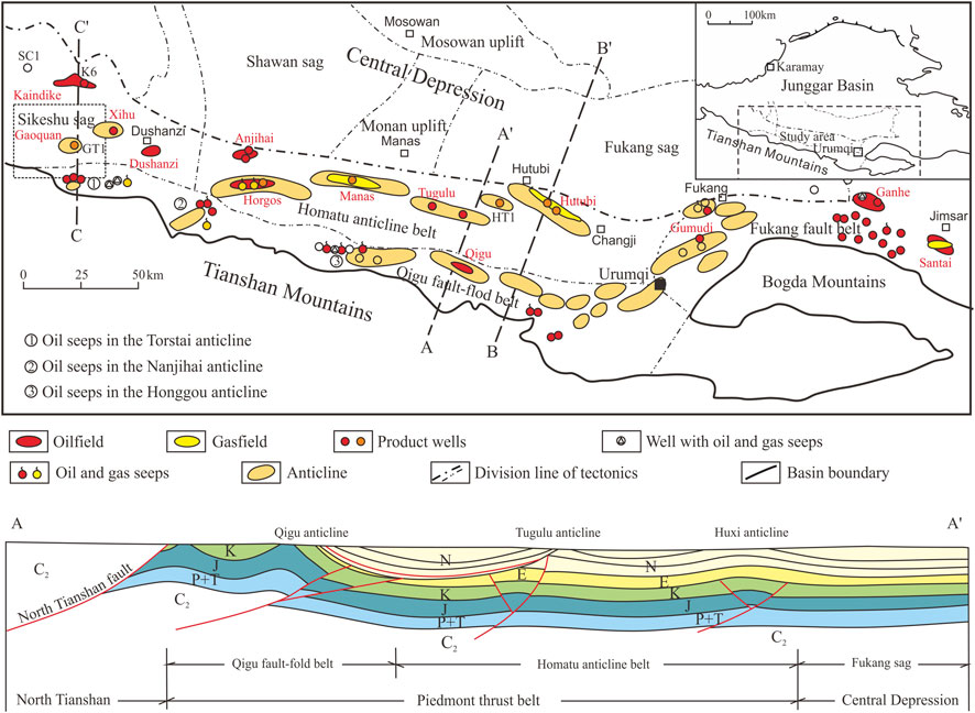
FIGURE 1. Distribution of structural traps and of oil and gas fields in the southern margin of Junggar Basin.
In the southern margin of Junggar Basin, petroleum geologists and prospectors got confused by many problems for a long time. For examples, is there any possibility for the discovery of large gas fields in the southern margin of Junggar Basin? Where are the favorable exploration areas and targets? What are the factors to induce the great difference in natural gas discovery between the southern margin of Junggar Basin and the Kuqa Depression of Tarim Basin which are located at the north and south depressions of the Tianshan Mountain?
In January 2019, high-product oil and gas flow were obtained from Well GT1 in the Gaoquan anticline of the Sikeshu sag, west part of the southern margin in the Junggar Basin, with 1,213 m3/d oil and 321.7 × 10³ m3/d natural gas from the deep Cretaceous strata (Chen et al., 2019; Du et al., 2019; Zhang et al., 2020). The daily oil and gas production from this well is the highest in the Junggar Basin so far. In December 2020, once again, high-product oil and gas flow were obtained from the Well HT1 at the depth of 7,367 to 7,382 m in the Huxi anticline (Figure 1) in the middle part of the southern margin in the Junggar Basin, with 610 × 103 m3/d natural gas and 106 m3/d oil. The great breakthrough in these two wells showed a great potential of oil and gas exploration in the southern margin of Junggar Basin.
In this study, based on our previous results about the genetic type of natural gas and its sources in the southern margin of Junggar Basin (Chen et al., 2019), we investigated the geological and geochemical conditions for natural gas generation and accumulation in the southern margin of Junggar Basin, and conducted a comparative study between the southern margin of Junggar Basin and the Kuqa Depression of Tarim Basin in terms of factors controlling the natural gas accumulation. Also, the favorable natural gas exploration areas and targets were discussed for strategy-making reference.
The southern margin of Junggar Basin starts from the Fukang fault zone in the east, extending to the Sikeshu sag in the west, and connects with the Shawan sag, Monan uplift and Fukang sag in the north, and with the north Tianshan Mountain in the south. It is 500 km in length from east to west, 40–60 km in width from south to north, and 21 × 103 km2 in area. In terms of regional tectonic background, the southern margin of Junggar Basin belongs to the piedmont thrust belt of the north Tianshan Mountain (Figure 1), and is the youngest and most complex fold belt in the Junggar Basin. Also, it is a secondary tectonic unit developed during the Late Hercynian, Indosinian-Yanshanian, and Himalayan periods (Yang et al., 2004; Kuang and Jia, 2005; Kuang and Qi, 2006; Chen et al., 2007). Based on the structural styles and their formation mechanisms, the southern margin of Junggar Basin can be further divided into four sub-tectonic units as the Sikeshu sag, the Homatu structural belt, the Qigu fault fold belt and the Fukang fault zone (Yang et al., 2004; Figure 1). From the Qigu fault fold belt to the Homatu structural belt, three rows of anticlines were developed from south to north. The first row includes the Torstai, Nananjihai, Honggou, Qingshuihe, and Qigu anticlines, etc., the second row is the Horgos, Manas and Tugulu anticlines, and the third row has the Anjihai, Huxi, and Hutubi anticlines, etc. In terms of geographic background, the southern margin of Junggar Basin can be divided into three parts as the west, the central and the east (Figure 1).
Six sets of sedimentary strata occur in the southern margin of Junggar Basin, including the Permian, Triassic, Jurassic, Cretaceous, Paleogene, and Neogene (Figure 2). In the central part, the gross thickness of sedimentary strata is up to 15 km, and relatively thin in the west and east parts, generally 8–12 km (Wang et al., 2013; Chen et al., 2015a; Chen et al., 2016c). Previous studies showed that the Permian source rock was one of the most important source rocks in the Junggar Basin. In the southern margin of Junggar Basin, the Middle Permian source rock deposited in the semi-deep to deep lacustrine facies, with a thickness of 600–1,600 m. Oil shale deposit in the east part of the southern margin was well-developed in the Lucaogou Formation in the Middle Permian (Graham et al., 1990; Carroll et al., 1992; Gao et al., 2016; Bai et al., 2017; Cao et al., 2017). The Upper Permian strata were mainly deposited in the fluvial-swamp to semi-deep lacustrine facies. The Middle-Lower Triassic strata are mainly composed of fluvial-shallow lacustrine coarse clastic deposits, while the Upper Triassic strata deposited in the shore-shallow to semi-deep lacustrine facies with a thickness of 300–800 m, interbedded with thin carbonaceous mudstone and coal seam of swamp facies. The Badaowan, Sangonghe, Xishanyao, and Toutunhe formations of Middle-Lower Jurassic strata are mainly coal-bearing deposits of fluvial and limnetic facies, which are widely distributed in the Junggar Basin, with a maximum thickness of 3,000 m in the southern margin, and generally 1,000–2,000 m. This set of coal measures is the main oil and gas source rocks in the southern margin of Junggar Basin (Wang et al., 2013; Chen et al., 2015a; Chen et al., 2016c). The Upper Jurassic strata include the Qigu Formation and the Karaza Formation, and it is a set of red coarse clastic deposits, which is widely distributed in the southern margin with a thickness of more than 600 m. The Lower Cretaceous strata are a set of semi-deep to shallow lacustrine deposits, which is widely distributed in the whole basin with the thickness of 1,594 m in the southern margin of Junggar Basin. It is relatively well-developed in the central part of the southern margin in respect to oil and gas generation potential (Wang et al., 2013; Chen et al., 2015a; Chen et al., 2016c). The Upper Cretaceous strata are mainly composed of fluvial coarse clastic deposits, with a thickness of 46–813 m, and generally 300–600 ms. The Paleocene-Eocene strata are fluvial-shallow lacustrine deposits, with a thickness of 15–855 m, and generally >450 m. The Eocene-Oligocene Anjihaihe Formation is mainly composed of deep-semi, deep-shallow lacustrine facies, with a thickness of 44–800 m and generally 350–650 m. Dark mudstone is relatively well developed in the west part of the southern margin. The Oligocene-Pliocene strata are mainly dominated by shallow lacustrine and fluvial deposits, with a thickness of 2,000–2,300 m. The Quaternary Xiyu Formation is composed of piedmont proluvial-alluvial fan-fluvial conglomerate and glutenite deposits, which is widely distributed in the southern margin of Junggar Basin, with a thickness of 350–2046 m, and generally >1,300 m. The thickness of the Quaternary Xiyu Formation in the west part is greater than that in the central and east parts.
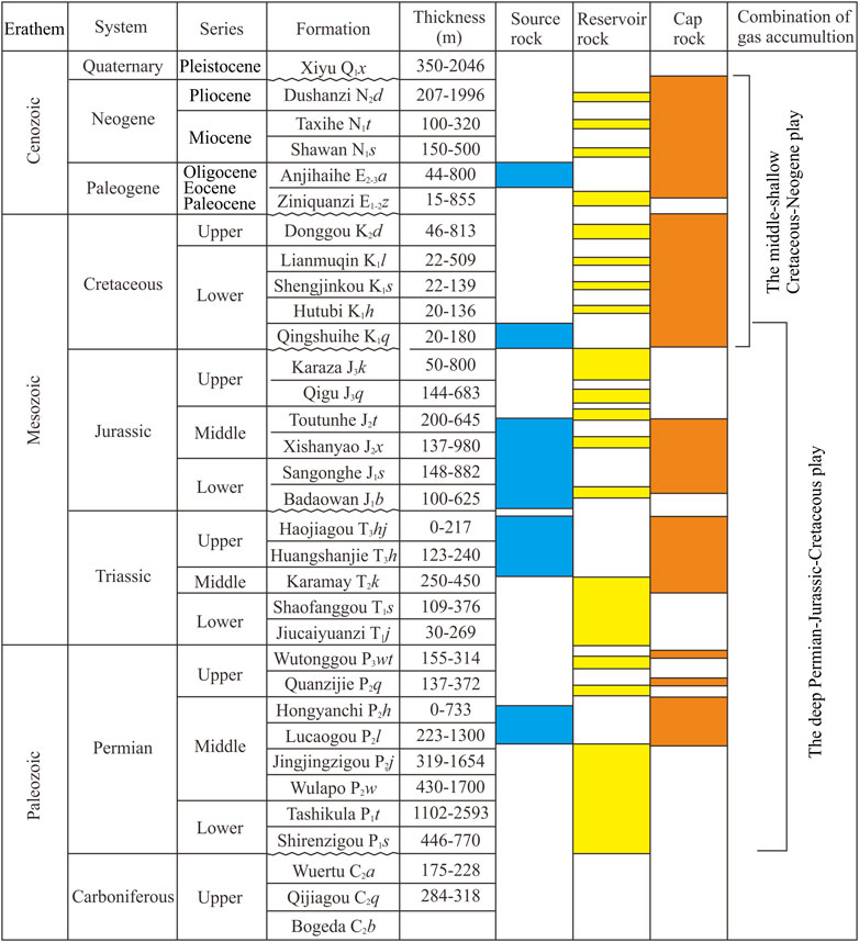
FIGURE 2. Sedimentary strata as well as combination of source rock, reservoir rock, and cap rock in the southern margin of the Junggar Basin.
Although many oil and gas seeps occur in the southern margin of Junggar Basin, and natural gas shows have also been found in lots of exploration wells (Wang et al., 2013; Chen et al., 2016b; Liu et al., 2016; Zheng et al., 2017), only two commercial gas fields have been discovered in the Hutubi anticline (the Hutubi gas field) and in the Manas Anticline (the Mahe gas field) in the central part (Figure 1). The natural gas fields discovered in other structures are mainly small-scale gas reservoirs or associated gas of oil reservoirs revealed by individual well drilling, including the Mazhuang gas field in the Santai, east part.
In these gas fields or gas-bearing structures, the natural gas reservoirs in the Hutubi, Tugulu, Manas, Horgos, and Anjihai anticlines in the central part are mainly located in the Paleogene Ziniquanzi and Anjihaihe formations, and minor in the Neogene Shawan Formation and the Upper Cretaceous Donggou Formation. The natural gas reservoirs in the Nananjihai structure are distributed in the Jurassic Badaowan Formation, while the natural gas reservoirs from the Qigu oilfield mainly distributed in the Triassic and Jurassic strata. The oil and gas reservoirs in the Dushanzi anticline, located in the west part of the southern margin, are mainly distributed in the Neogene Shawan Formation and Taxihe Formation. Two condensate gas layers in the Neogene Shawan Formation have been penetrated in Well Du1 and Well XC2. The oil and gas reservoirs in the Kaindick, Xihu, and Gaoquan anticlines in the west part are mainly distributed in the Jurassic Qigu Formation and the bottom of the Lower Cretaceous Qingshuihe Formation. The natural gas reservoirs in the Mazhuang gas field in the east part are mainly in the Upper Jurassic strata. Vertically, oil and gas discovered in the central part are mainly in the middle-shallow Upper Cretaceous-Neogene, while oil and gas discovered in the west part are much deeper, mainly in the Upper Jurassic-Lower Cretaceous.
Recently, high-product oil and gas flow was discovered in Well GT1 in the Gaoquan anticline of the Sikeshu sag (Figure 1), west part of the southern margin in the Junggar Basin (Chen et al., 2019; Du et al., 2019), and the oil and gas reservoirs are located in the Toutunhe Formation of Middle Jurassic (Figures 3, 4). Although it is difficult at moment to determine the boundary and scale of oil and gas reservoirs, it was predicted that the structural high trap area of the Gaoquan anticline is about 69 km2 with the closure height is 450 m, and the Cretaceous structural high trap area where Well GT1 was drilled is about 28 km2. Thereafter, large oil and gas field is being expected in Gaoquan anticline. More recently, a high-product commercial oil and gas field was discovered in Well HT1 at the depth of 7,367–7,382 m in the Huxi anticline in the middle part of the southern margin (Figure 1). It was estimated to be 100 billion cubic meters of natural gas reserve.
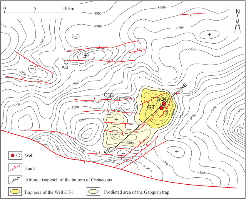
FIGURE 3. Structural map of Gaoquan anticline and adjacent Cretaceous bottom boundary in west of southern margin.
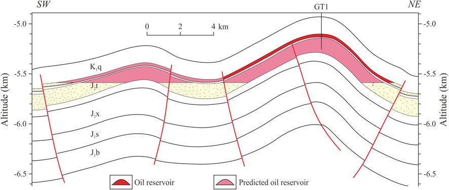
FIGURE 4. Predicted reservoir profile (through Well GT1) of Gaoquan anticline in west of southern margin (Its location is indicaten in Figure 3).
The stable carbon and hydrogen isotopic compositions of gasoline hydrocarbons is considered to be closely related to the sedimentary environments, organic matter types and thermal maturity, and can be widely used to determine the genetic types and sources of natural gas (Stahl, 1974; Schoell, 1980; Schoell, 1983; Bernard et al., 1977; James, 1983; James, 1990; Whiticar, 1994; Whiticar, 1996; Whiticar, 1999). Previously, a large body of publications have been focused on the geochemical characters and sources of natural gas discovered in the southern margin of Junggar Basin (Wang et al., 2009; Hu et al., 2010; Wang et al., 2013; Liu et al., 2016; Zheng et al., 2017; Chen et al., 2019), and it is now generally accepted that natural gas discovered in the southern margin of Junggar Basin is thermogenic gas (Chen et al., 2019).
In respect to genetic types and sources of natural gas in the southern margin of Junggar Basin, previous studies by Wang et al. (2009), Hu et al. (2010), Wang et al. (2013), and Liu et al. (2016) suggested that it is mainly coal-derived gas from the Jurassic coal-measures. However, Chen et al. (2019) recently conducted a systematic comparative study on the components and the stable carbon isotopic compositions of natural gas from different anticline structures in the southern margin, and found that the geochemical characters of natural gas from different structures in the southern margin of Junggar Basin were quite different. They can be divided into three types as coal-derived gas, mixed gas and oil-associated gas, of which coal-derived gas and mixed gas are dominated (Figure 5). The main genetic types of natural gas are coal-derived gas and mixed gas in the Kaindick, Xihu, and Dushanzi anticlines in the west part of the southern margin, while mixed gas in Well GT1 at the Gaoquan anticline. In the central part, the coal-derived gas is dominated in the Anjihai, Horgos, Manas, Tugulu, and Hutubi anticlines, and mixed gas and coal-derived gas are dominated in the Qigu anticline, while the oil-associated gas in the Nananjihai Anticline. In the Mazhuang gas field from the Santai, Fukang fault fold belt in the east part of the southern margin, the oil-associated gas is the main genetic type.

FIGURE 5. Carbon isotopic composition and types of natural gas in southern margin (Modified from Chen et al., 2019. The data regarding mud volcano are cited from Dai et al., 2012, and the data for the Northwestern margin is provided by the Research Institute of Xinjiang Oilfield Company).
Gas-source correlation results suggested that natural gas from the Kaindick, Xihu, and Dushanzi anticlines in the west part of the southern margin was derived mainly from the Jurassic coal-measures, and minor from the Permian lacustrine source rocks (Chen et al., 2019). The natural gas from Well GT1 was sourced from the Jurassic coal measures and the Permian lacustrine source rocks. The natural gas from the second and third row anticlines in the Homatu anticline belt in the central part of the southern margin was derived mainly from the Jurassic coal-measures, while the natural gas from the first row anticlines in the Qigu fault fold belt was sourced mainly from the Permian lacustrine source rocks and the Jurassic coal-measures, minor from the Upper Triassic lacustrine-limnetic source rocks. In the Mazhuang gas field in the Santai, Fukang fault fold belt in the east part of the southern margin, the natural gas was derived mainly from the Permian lacustrine source rocks, and minor from biogenetic gas due to biodegradation of crude oil generated from the Permian source rocks. The results clearly showed that in the southern margin of Junggar Basin, the Jurassic coal-measures is the most important source rock of natural gas, and the Permian lacustrine source rock is the second one. The Triassic lacustrine-limnetic source rock may also be regionally important gas source rocks.
Five sets of source rocks from the Permian, Triassic, Jurassic, Cretaceous, and Paleogene strata occurred in the southern margin of Junggar Basin, and the thickness of source rocks mainly depends on its location. In the central part of the southern margin, there are 5 sets of source rocks, while 2-4 sets in east and west parts (Wang et al., 2013; Chen et al., 2015a; Chen et al., 2016c).
The Middle Permian Lucaogou Formation lacustrine source rocks are mainly distributed in the areas from the east part to the central part of the southern margin, with a thickness of 50–250 m, and the maximum thickness up to >700 m in the east part (Carroll, 1998; Wang et al., 2013). The organic carbon content of source rocks ranges from 0.50 to 34.27%, with an average of 6.60%. The average hydrocarbon generation potential (S1+S2) is 36.99 mg/g.rock. The organic matters are dominated by sapropelic type (type I) and humic-sapropelic type (type IIA). The Middle Permian Lucaogou Formation lacustrine source rock is now at the low-mature stage at the outcrops in the east part of the southern margin (Wang et al., 2013; Hou et al., 2021). In the sags of the Homatu anticline belt, the Permian source rock is buried greater than 10 km and reached the highly to over mature stage, and was considered to be an effective gas source rock (Wang et al., 2013; Chen et al., 2015a). Crude oils from the Permian source rocks have been previously found in the Dushanzi anticline (Wang et al., 2013; Chen et al., 2016a; Chen et al., 2016b). In Well GT1 and Well K6, half of the natural gas with lighter carbon isotope composition was derived from the Permian source rocks (Chen et al., 2019). These results suggested that the Permian lacustrine source rocks could be an important source rock in the west part of the southern margin. Therefore, further study using seismic and drilling data to determine the distribution and scale of the Permian lacustrine source rocks is needed.
The lacustrine source rock in the Upper Triassic Huangshanjie Formation is also widely distributed in the southern margin of Junggar Basin (Chen et al., 2003; Kang et al., 2012; Wang et al., 2013; Chen et al., 2015a; Chen et al., 2016c), with a thickness of 50–300 m. The total organic carbon is lower than that of the Permian Lucaogou Formation, with an average TOC of 2.89%. The organic matters are mainly type II and type III. The burial depth of the Huangshanjie Formation is now up to >9 km in the central sag, and reaches highly to over mature stage, resulting in an effective source rock. This set of source rock is relatively well developed and is an important candidate as natural gas source rock in the central part of the southern margin and the Fukang sag in the east part.
The Middle-Lower Jurassic source rock is widely distributed in the southern margin of Junggar Basin. In Badaowan Formation of the Lower Jurassic, the dark mudstone, carbonaceous mudstone, and coal seam are generally 200–300 m, 1–10 m, and 5–50 m in thickness, respectively. The thickness of dark mudstone ranges from 50 m to 300 m in the Sangonghe Formation. The thickness of dark mudstone, carbonaceous mudstone and coal seam in the Xishanyao Formation is 75–150 m, 2–15 m and 5–30 m, respectively. The total organic carbon of dark mudstone from the Middle-Lower Jurassic strata ranges from 0.5 to 6.0%, with an average of 1–2% in different Formations. The average TOC of carbonaceous mudstone is about 20%, and ∼50–60% for coal seam. The organic matters of the Middle-Lower Jurassic source rocks are mainly type IIB and type III, with type IIA limited. Although the vitrinite reflectance of organic matter from the Jurassic outcrop source rocks ranges from 0.5 to 0.7%, it reaches highly to over mature stage in the depression due to burial depth of >8 km (Figure 6). Previous studies concluded it was the most important source rock in the southern margin (Wang et al., 2013; Chen et al., 2015a; Chen et al., 2016c).
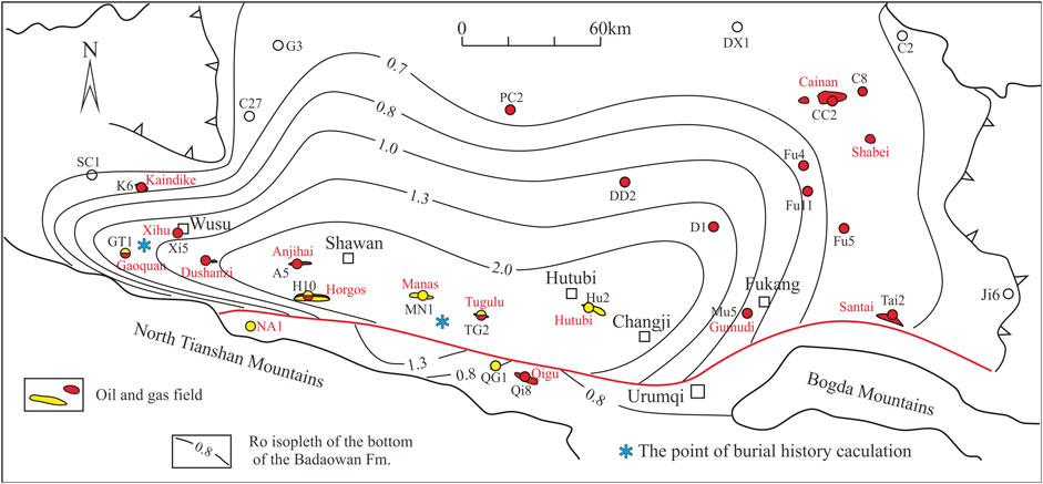
FIGURE 6. Maturity of source rocks at the bottom of Jurassic and the distribution map of main oil and gas fields (wells) from Jurassic in southern margin of Junggar Basin.
The Qingshuihe Formation of Lower Cretaceous lacustrine source rock is widely distributed in the southern margin, but the most developed in the central part of the southern margin with a thickness of 150–200 m, compared to a general thickness of 50–150 m in other parts of the southern margin. The TOC of mudstone ranges from 0.06 to 1.81% with an average of 0.92%. The organic matters are dominated by type I and type IIA. Although organic matter in outcrop samples showed low mature stage, it reaches peak to late oil generation stage in the depression due to burial depth of up to 6–8 km. In the central part of the southern margin, the crude oil was mainly derived from the Qingshuihe source rock (Liao et al., 2006; Wang et al., 2013; Chen et al., 2016b; Chen et al., 2016d; Chen et al., 2016e).
The Paleogene Anjihaihe Formation lacustrine source rock is mainly distributed in the central and west parts of the southern margin, with a thickness of 50 m–200 m. The average TOC is 1.03%, but shows a great change depending on location. Organic carbon content of source rocks from the Sikeshu sag in the west part is much higher, with an average TOC of 1.41%, and the hydrocarbon generation potential is 5.02 mg/g. rock. The organic matter is dominated by type II. In the central and east parts, organic carbon content of dark mudstone is relatively low, and the organic matter is dominated by type III. Organic matter from the outcrop dark mudstone is now at immature stage. However, the thermal maturity of organic matter in source rocks from the Sikeshu Sag to the central part reaches low mature-mature stage in respect to its depth of 5,000–6,500 m. The crude oil in the Paleogene-Neogene reservoirs is sourced from this set of source rock in the Dushanzi, Kaindick, Xihu and Gaoquan anticlines in the west part (Wang et al., 2013; Chen et al., 2016b; Chen et al., 2016d). Therefore, it is an effective oil source rock, with little gas potential.
Conclusively, the effective source rocks for natural gas generation in the southern margin of Junggar Basin are mainly the Middle-Lower Jurassic coal measures, the Upper Triassic limnetic and the Permian lacustrine source rocks.
Previous studies suggested that the paleo-geothermal field in the southern margin of Junggar Basin experienced a gradual cooling process as revealed by the geothermal gradient from 32.0–36.6°C/km in Permian to 18–22°C/km at present (Wang et al., 2000; Qiu et al., 2001). Within the constraint of measured vitrinite reflectance of drilled source rocks, the thermal evolution and hydrocarbon generation history of source rocks from the sags in the central and west parts were calculated by basin modeling software (Figure 7). In the central part, the burial depths of the Permian, Triassic and Jurassic source rocks are much deeper (Figure 8), and the hydrocarbon generation occurred relatively early. In the southern sag of the Manas anticline in Homatu structural belt, the main oil generation period of the Middle Permian source rock was in Cretaceous (150–60 Ma), and the main gas generation period was in Paleogene-Oligocene (60–20 Ma; Figure 7A). The source rock from the Upper Triassic strata mainly generated oil at the end of Early Cretaceous to Paleogene (110–30 Ma), and the main gas generation period at Miocene (20–5 Ma). The main oil generation period of the Middle-Lower Jurassic source rocks occurred at the Late Cretaceous to Oligocene (100–20 Ma), and the peak oil about 90–25 Ma from the Late Cretaceous to Eocene. Gas generation from kerogen-cracking (Ro = 1.0%) started at the beginning of Eocene (40 Ma), and currently reaches peak gas generation stage. The Lower Cretaceous source rock is now mainly at the peak and late oil generation stage.
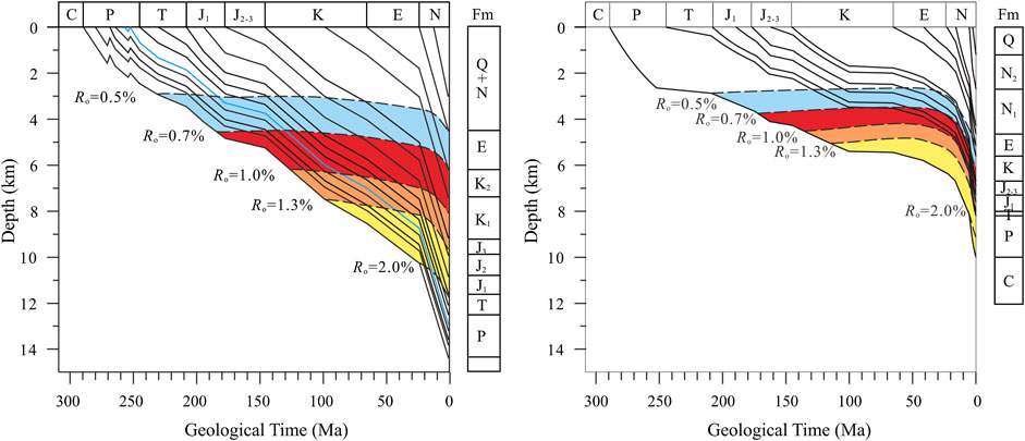
FIGURE 7. Burial evolution and hydrocarbon generation history of source rocks in the middle and western parts of southern margin. (A) Middle part of sedimentary sag in the middle of southern margin (see Figure 6 for location); (B) Middle and west parts of Sikeshu Sag in the west of southern margin (see Figure 6 for location).

FIGURE 8. Sketch diagram of structure, source rock burial evolution and hydrocarbon migration and accumulation section in the middle of southern margin.
It is still unclear to date about the distribution of the Permian-Triassic source rocks in the west part of the southern margin in Junggar Basin. According to seismic interpretation, the Permian-Triassic strata are about 1800–2,300 m in thickness, and are 6–8 km in burial depth in the mid-west of the Sikeshu sag (Figure 9), much shallower than that in the central part. Therefore, the main hydrocarbon generation time in the mid-west of the Sikeshu sag could be much later than that in the central part. The Lower Permian source rock (equivalent to the Fengcheng Formation) mainly generated oil during the Late Jurassic to Early Cretaceous (160–100 Ma), and the main gas generation period started from the Late Cretaceous and continues to present (Figure 7B). Because the Cretaceous and Paleogene strata in the Sikeshu sag are much thinner than that in the central part, the hydrocarbon generation period of the Jurassic coal-measures in the Sikeshu sag should be later than that in the central part. The main oil generation stage started from Eocene and continues to present, and it is still at the peak oil to late stage oil generation. The Lower Cretaceous source rock generated oil much later, which was mainly at the mature stage of oil generation. The Paleogene source rock is at immature to early mature stage of oil generation, and basically has no potential for natural gas generation.
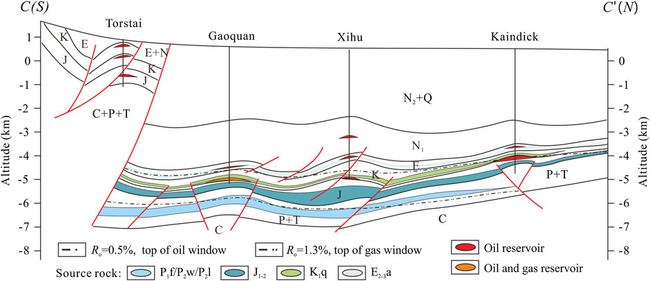
FIGURE 9. Sketch diagram of structure, source rock burial evolution and hydrocarbon migration and accumulation section in the west of southern margin.
The Kuqa Depression of Tarim Basin and the southern margin of Junggar Basin are located on south and north sides of the Tianshan Mountains, respectively, with similar sedimentary cap rocks and tectonic evolution history in respect to petroleum geological background (Hendrix et al., 1994; Li et al., 2000; Kuang and Liu, 2001; Liang et al., 2002; Liang et al., 2004; Fang et al., 2005; Kuang and Jia, 2005; Kuang and Qi, 2006; Fang et al., 2007; He et al., 2009). Many large gas fields have been discovered to date in the Kuqa Depression, such as KL-2, Dabei, Keshen and Dina gas fields (Wang, 2014). However, in the southern margin of Junggar Basin, only two medium-sized gas fields have been found in the Hutubi and Manas anticlines. The main factors leading to the exploration differences between the Kuqa Depression and the southern margin of Junggar Basin were investigated for a long time and are still unclear to date. Kuang and Liu (2001) made a comprehensive comparison on the hydrocarbon accumulation conditions between the two regions, and concluded that both were excellent gas source, fold anticlines, and effective regional cap rocks. The main difference is that in the Kuqa Depression, the quality of the reservoir rock is much better and faults connected source rocks with reservoirs were well developed. Also, the preservation is better in the Kuqa Depression than that in the southern margin of Junggar Basin. Thereafter, it was considered that natural gas accumulation conditions in the southern margin of Junggar Basin are worse than those in the Kuqa Depression. However, recent discovery of high-product oil and gas flow in the Well GT1 and Well HT1 suggested that gas accumulation conditions in the southern margin are probably not worse than expected previously, and need a deep insight on the factors controlling gas generation and accumulation in the southern margin of Junggar Basin.
It is now generally accepted that the Middle-Lower Jurassic coal-measures are main source rocks in the Kuqa Depression and the southern margin of Junggar Basin, followed by the Upper Triassic lacustrine-limnetic source rocks (Du et al., 2006; Qin et al., 2007; Wang et al., 2013; Chen et al., 2015a; Chen et al., 2016c). In the Kuqa Depression, the cumulative thickness of Middle-Lower Jurassic limnetic mudstone and carbonaceous mudstone is 100–600 m, and the cumulative thickness of coal seams is generally 5–30 m (Liang et al., 2004). The mudstone in the Yangxia and Kizilonur Formations of Lower Jurassic is generally 50–500 m in thickness, and the coal seams can reach a maximum thickness of 52 m. The thickness of mudstone in the Chakemak Formation generally ranges from 50 to 150 m. The dark mudstone and carbonaceous mudstone in the Upper Triassic Taliqike Formation are generally 50–150 m in thickness, and the coal seams are generally 0.5–7 m, with a maximum thickness of 12 m.
In the southern margin of Junggar Basin, the cumulative thickness of the Middle-Lower Jurassic limnetic dark mudstone and carbonaceous mudstone is 200–700 m, and the cumulative thickness of coal seams is 10–50 m with a maximum thickness of 60 m (Wang et al., 2013; Chen et al., 2015a; Chen et al., 2016c). The mudstone in the Badaowan Formation of Lower Jurassic is generally 200–300 m in thickness, and the cumulative thickness of coal seams is generally 5–20 m (up to 50 m). The mudstone of the Sangonghe Formation is generally 50–300 m in thickness; the mudstone of the Xishanyao Formation of Middle Jurassic is generally 75–150 m, and the cumulative thickness of coal seams is 5–30 m with a maximum thickness of >40 m. The lacustrine and limnetic source rocks from the Upper Triassic Huangshanjie and Haojiagou Formations are generally 50–300 in thickness, which is similar to those in the Kuqa Depression, but the distribution of coal-measures in the Haojiagou Formation is not as stable as that in Kuqa Depression. As discussed in Bulk Characters of Source Rocks, three sets of source rocks occurred in the southern margin of Junggar Basin, including the Lower Permian/Middle Permian, the Lower Cretaceous and Paleogene source rocks, which were not developed in the Kuqa Depression, suggesting multiple sets of source rocks in the southern margin of Junggar Basin, and even the Middle-Lower Jurassic coal-measures were developed better than those in the Kuqa Depression (Table 1). However, the Upper Triassic lacustrine and limnetic source rocks in the southern margin of Junggar Basin are basically equivalent to or slightly worse than those in the Kuqa Depression.
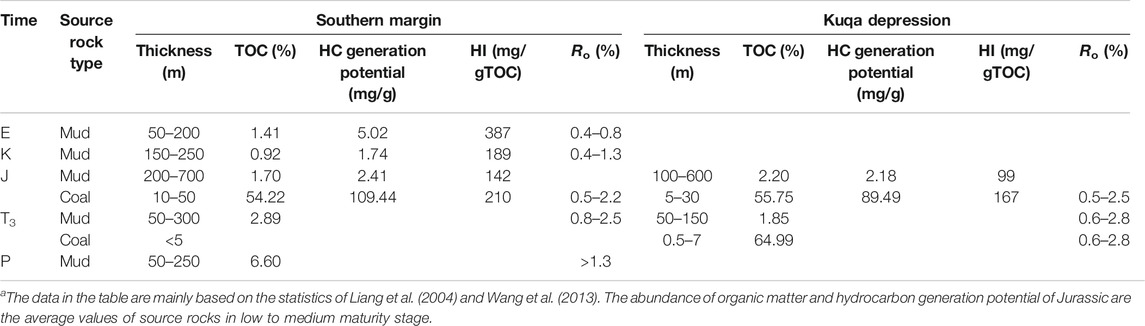
TABLE 1. Comparison of source rocks between southern margin and Kuqa Depressiona.
As showed in Table 1, at low-medium maturity, hydrocarbon generation potential of Jurassic dark mudstone, carbonaceous mudstone and coals from the southern margin of Junggar Basin is higher than those of the Jurassic coal measures from the Kuqa Depression (Liang et al., 2004; Wang et al., 2013; Chen et al., 2015a). This is mainly due to the relatively low content of hydrogen-enriched liptinites in coal measures from the Kuqa Depression. The relative percentage of inertinites in mudstone and carbonaceous mudstone from the Kuqa Depression is about 25–50%, and 40–70% vitrinite as well as 3–8% liptinites. However, the relative percentage of inertinites in mudstone and carbonaceous mudstone from the southern margin of Junggar Basin is only 8–10%, and 56–68% vitrinite as well as 25–33% liptinite. This is the same case in coal seams. The relative percentage of inertinites reaches up to 28%, vitrinite to 70%, and liptinites to 2% in coals from the Kuqa Depression. While the relative percentage of inertinites is only 16%, and 64% vitrinite as well as up to 20% liptinites in coals from the southern margin of Junggar Basin (Liang et al., 2004; Qin et al., 2007; Wang et al., 2013). In addition, the average TOC of dark mudstones from the Upper Triassic Huangshanjie and Taliqike Formations in the Kuqa Depression is 1.09 and 1.81%, respectively. However, the average TOC of Upper Triassic mudstone and carbonaceous mudstone is 2.89% in the southern margin of Junggar Basin, higher than that in the Kuqa Depression. Therefore, the hydrocarbon sources in the southern margin of Junggar Basin are better than those in the Kuqa Depression.
The maturity of organic matter in Jurassic coal-measures from the Kuqa Depression is higher than that in the southern margin of Junggar Basin. At present, the maturity of organic matter in Jurassic coal measures from the Kuqa Depression ranges from 0.8 to 2.5% as revealed by vitrinite reflectance, showing an increasing trend from east to west with the highest of 2.8% (Wang et al., 1999; Liang et al., 2004). In the eastern region, the Jurassic coal-measures is mainly at the peak oil to late oil stages, while in the central and west parts, source rocks are mainly at highly to over mature stage (equivalent to wet gas-dry gas stages). However, the maturity of organic matter in Jurassic coal measures from the southern margin of Junggar Basin ranges from 0.7 to 2.2% as revealed by vitrinite reflectance, showing an increasing trend from west to east. The Jurassic coal-measures is mainly at peak oil stage in the west part, but mainly at high-mature wet-gas stage in the central part. No source rock reaches at dry gas stage. Therefore, the maturity of organic matter in source rocks from the Kuqa Depression is much higher than that in the southern margin of Junggar Basin, which may be one of the main factors controlling gas generation and accumulation in the Kuqa Depression.
Basin modeling results showed that the total generated hydrocarbon amount from Jurassic source rocks in the southern margin of Junggar Basin is about 397.3 × 10⁹ t (Du et al., 2019), and the total expelled hydrocarbon amount is about 140.3 × 10⁹ t (including the total expelled oil amount of 38.9 × 10⁹ t, and total expelled gas amount of 127 × 1012 m3). The average intensity of hydrocarbon generation, hydrocarbon expulsion and gas expulsion were 18.92 × 10⁶ t/km2, 6.68 × 10⁶ t/km2 and 6 × 10⁹ m3/km2, respectively. Also, the Permian and the Upper Triassic source rocks can contribute hydrocarbon resources, which was not included here. Therefore, the southern margin of Junggar Basin has rich sources for hydrocarbon accumulation.
Both the Jurassic and Cretaceous sandstones as reservoir rocks in the Kuqa Depression showed high quality (Kuang and Liu, 2001). The porosity and permeability of Jurassic sandstones are 6–21% and 0.1 × 10⁻³–300 × 10−3 μm2, respectively. While the porosity and permeability of Cretaceous Basjiqike Formation sandstone reaches 8.7–19.2% and 87 × 10−3–696 × 10−3 μm2, respectively, typical characters of medium porosity and medium permeability reservoir rocks. Furthermore, the Cretaceous Formation sandstone was widely distributed in the Kuqa Depression with huge thickness of 90–500 m (Wang and Hu, 2002). However, compared to the Kuqa Depression, the Jurassic, Cretaceous and Tertiary reservoir rocks are generally poor in quality in the southern margin of Junggar Basin (Kuang and Liu, 2001). In fact, the deep buried reservoirs showed extremely low porosity and ultra-low permeability in the Kuqa Depression, with a porosity of 3–9% (averaging 5.4%) and a matrix permeability of 0.35 × 10⁻³ to 0.5 × 10⁻³ μm2 (Wang, 2014).
Sandstones from the Upper Jurassic Qigu Formation and the Karaza Formation are the effective reservoir rocks in the southern margin of Junggar Basin. The sandstone from the Jurassic Qigu Formation mainly deposited in the braided delta front with an area of >15,000 km2, resulting in changing physical properties, and thereafter leading to low porosity and low permeability. In the west part of the southern margin, the sandstone from the Jurassic Qigu Formation is relatively thin, with thickness of 100–236 m. The porosity ranges from 3 to 25%, with an average of 10–21%; the permeability ranges from 0.1 × 10⁻³ to 1,640 × 10−3 μm2, with an average of 4 × 10⁻³–162 × 10−3 μm2 (Zhang et al., 2012). In the central part of the southern margin, sandstone from the Jurassic Qigu Formation is much thicker, with a thickness of 60–384 m. The porosity ranges from 9.27 to 14.38%, with an average of 11.5%, and the permeability ranges from 0.16 × 10⁻³ μm2 to 17.68 × 10⁻³ μm2. Therefore, sandstone from the Jurassic Qigu Formation has medium porosity and low permeability (Wu et al., 1994). The Jurassic Karaza Formation is mainly distributed in the central and east parts of the southern margin, with relatively limited potentials. Large alluvial fan and braided river delta were well developed, resulting in the formation of a set of very thick massive conglomerate and sandstone. In outcrop area, the thickness of glutenite is usually >150 m, with a maximum thickness up to 860 m in the Karaza area (Du et al., 2019). The exploration results revealed that sandstone from the Jurassic Karaza Formation was 210–450 m in thickness, with an area of 10,000 km2, and showing mainly medium-low porosity and medium-low permeability. Regionally, high-quality Jurassic Karaza reservoir rocks were well developed, with an average porosity of 16–19%, and permeability of 100 × 10−3–260 × 10−3 μm2 (Han et al., 2012; Lei et al., 2012; Du et al., 2019).
The Cretaceous reservoir rock is mainly composed of glutenite and sandstone at the bottom of the Qingshuihe Formation of Lower Cretaceous in the southern margin of Junggar Basin. Previous study by Fang et al. (2006) suggested that this set of reservoir rock was low quality with thin deposit (10–30 m), and was mainly distributed at the basin edge and low uplifts in the central part. However, recent study indicated that the Cretaceous sandstones developed mainly from braided river delta and fan delta front at the bottom of the Qingshuihe Formation, with a thickness of 20–100 m and an area of 15,000 km2 (Du et al., 2019). The sandstone shows good in the physical properties, with porosity of 9.0–18.6% (averaging 15–18%), permeability of 97.75 × 10⁻³–186.00 × 10⁻³ μm2. It can be defined as medium-low porosity and medium-high permeability. The main pore type in sandstone from the Qingshuihe Formation is primary residual intergranular pores, with good connectivity. For example, the porosity of sandstone from the Qingshuihe Formation in Well GT1 ranges from 13.4 to 18.4% at the interval of 5767.5–5774.7 m on the basis of well logging interpretation. High-product oil and gas flow confirmed that sandstone from the Cretaceous Qingshuihe Formation also is the excellent reservoir rocks.
Sandstones from the Paleogene Ziniquanzi Formation and the Neogene Shawan Formation are also the effective reservoir rocks in the southern margin of Junggar Basin, with a thickness generally ranging from 10 to 80 m (Lei et al., 2008; Xiao et al., 2011; Bai et al., 2013a). Sandstone from the Ziniquanzi Formation in Homatu structural belt showed medium-high porosity and medium-high permeability, with a porosity of 1.8–34% (mainly 21–26%, averaging 18.94%). The permeability ranges from 0.06 × 10⁻³ to 1000 × 10−3μm2, and mainly 4 × 10⁻³ to 640 × 10−3 μm2, with an average of 197 × 10−3μm2. Sandstones from the Ziniquanzi Formation and Shawan Formation in the Sikeshu sag are relatively poor in quality as reservoir rock, with porosity of 9–16% and permeability of 10 × 10−3–127 × 10−3 μm2. Therefore, reservoir rocks distributed in the Jurassic to Neogene were relatively well-developed in the southern margin of Junggar Basin, and their quality is similar to those in the Kuqa Depression.
The strong thrust and compression during Himalayan orogeny in the Kuqa Depression resulted in the development of structures in rows and belts, which can be divided into upper and lower structural layers. Natural gas discovered to date was mainly accumulated in the lower structural layer. The thrust faults directly connected source rocks with the lower structural layer, being good vertical migration pathways (Kuang and Liu, 2001; He et al., 2009; Wang, 2014). In the southern margin of Junggar Basin, structural traps were also well developed (Li et al., 2003; Kuang and Jia, 2005; Kuang and Qi, 2006; Lei et al., 2012), which were not only in the shallow structural layer, but also in the deep structural layer. Total 45 traps have been identified to date in the middle-shallow structural layers of the piedmont thrust belt (Li et al., 2003), and 40–46 traps have been preliminarily identified in the deep layer (Lei et al., 2012; Du et al., 2019), of which 21 traps in the deep layer were confirmed, with a total trap area of 2,486 km2. Most of these traps are anticlines that were formed during the Neogene period (Hendrix et al., 1994; Deng et al., 1999; Fang et al., 2005; Hu et al., 2005; Guo et al., 2006; Du and Wang, 2007; Fang et al., 2007) and are similar to those in the Kuqa Depression. The trap formation time in the southern margin of Junggar Basin matched well with the time of gas generation from the Jurassic coal-measures, which is also similar to that in the Kuqa Depression.
Previously, Kuang and Liu (2001) argued that no fault system connected deep source rocks with the upper anticline traps in the southern margin of Junggar Basin. However, recent study clearly showed faults connecting deep source rocks with the shallow structural traps in the southern margin of Junggar Basin (Figures 4, 8, 9). This was evidenced by oil and gas shows in outcrops and drilled wells in the southern margin of Junggar Basin, and commercial natural gas fields were also discovered in the shallow Paleogene and Neogene reservoirs from the Manas and Hutubi anticlines. Natural gas was sourced mainly from the deep Jurassic coal-measures, and migrated into shallow layers through fault systems (Wang et al., 2013; Chen et al., 2015b; Chen et al., 2016c; Chen et al., 2017). The results suggested that the fault systems connecting the deep source kitchen with the upper traps were well developed in the southern margin of Junggar Basin, that were favor for the upward migration of deep oil and gas.
Two sets of regional cap rocks mainly occurred in the Kuqa Depression. The first one is the Paleogene gypsum-salt rock and gypsum-mudstone cap rock, and the second is the Lower Cretaceous Shushanhe Formation-Jurassic Qigu Formation mudstone. The deposits of cap rocks in the Kuqa Depression were widely distributed with excellent sealing capability, especially for the Paleogene gypsum-mudstone salt rock (Kuang and Liu, 2001; Wang and Hu, 2002). There are also two sets of regional cap rocks developed widely in the southern margin of Junggar Basin. One is the mudstone from the Qingshuihe Formation-Hutubi Formation of Lower Cretaceous, and another is lacustrine mudstone from the Paleogene Anjihaihe Formation. Basically, the quality of the cap rock in the Kuqa Depression is better than that in the southern margin of Junggar Basin in terms of rock characters.
The Qingshuihe Formation in the southern composed of gray and grayish green mudstone, interbedded with thin argillaceous siltstone. A set of thick basal conglomerate is well developed at the bottom of Qingshuihe Formation, with ratio of mudstones to strata of 0.5–1.0. The total thickness of mudstone drilled is 188 m, and the maximum thickness of individual layer is 78 m. The Hutubi Formation is mainly composed of grayish green and brownish red mudstone, with a thickness of 300–700 m, and a maximum thickness of individual layer up to 138 m (Du et al., 2019). The lacustrine mudstone in the Anjihaihe Formation of Paleogene is generally 50–200 m in thickness. Although no gypsum-mud salt rock developed in the Cretaceous and Paleogene strata in the southern margin of Junggar Basin, overpressure occurred in the mudstones of the Middle-Lower Jurassic, Lower Cretaceous, and Paleogene Anjihaihe Formation (Kuang, 1993; Wu et al., 2000; Zha et al., 2000; Wang et al., 2003; Luo et al., 2004; Wu et al., 2006; Luo et al., 2006; Luo et al., 2007). The pressure coefficient ranges from 1.3 to 2.0 with a maximum up to 2.43, and most of them >1.8. Regionally, mudstone system in the west of the southern margin showed high overpressure, while low overpressure in the east. For example, a repeat formation test (RFT) showed pressure coefficients of 2.2 and 2.4 (with an excess pressure of approximately 40–44 MPa) in the lower part of the Cretaceous Qingshuihe Formation and the Anjihaihe Formation from the Gaoquan and Anjihai anticlines in the west, respectively (Luo et al., 2007; Du et al., 2019). The excess pressure in the lower part of the Anjihaihe Formation from the Manas and Tugulu anticlines is approximately 20 MPa, whereas on the Hutubi anticline to the east, the pressure in the same formation and the underlying strata is close to hydrostatic pressure (Luo et al., 2007). The widespread occurrence of overpressure indicates that mudstone system can be good sealing capability in the southern margin of Junggar Basin.
In fact, oil and gas discovered in the Jurassic reservoirs in Kaindick oilfield demonstrated a good sealing capability of mudstones in the Cretaceous Qingshuihe Formation in the southern margin of Junggar Basin. Also, the Dushanzi oil field, Mahe gas field and Hutubi gas field showed good Paleogene and Neogene reservoir–cap rock combination. The exploration facts strongly suggest that the mudstone systems in the southern margin of Junggar Basin can act as good cap rocks for large and medium oil and gas accumulation.
Although source rocks in the Permian, Triassic, Middle-Lower Jurassic, Lower Cretaceous Qingshuihe Formation, and the Lower Tertiary Anjihaihe Formation have been proved to be effective source rocks in the southern margin of Junggar Basin, the main oil and gas generation periods of source rocks are quite different, which strongly depend on the location of source rocks. The relationship between hydrocarbon generation time and the formation time of structural traps is a key factor controlling the formation of large oil and gas reservoirs.
The southern margin of Junggar Basin started to uplift greatly since Miocene (25 Ma). Therefore, the anticline structures in this area were developed very late (Fang et al., 2005; Hu et al., 2005; Guo et al., 2006; Du and Wang, 2007; Fang et al., 2007). The Qigu anticline and other anticlines in the first row were formed before ∼10–7 Ma; the Horgos anticline and other anticlines in the second row were formed before 3–1.5 Ma; the Anjihai anticline and other anticlines in the third row were formed before 1 Ma, while the Hutubi and Xihu anticlines etc. were formed much later. Therefore, the structures in the first row can only capture the oil and gas formed since ∼10 Ma, the structures in the second row can capture oil and gas since ∼3 Ma, and the structures in the third row can capture oil and gas since 1 Ma. By comparing the relationship between the oil and gas generation time from five sets of source rocks and the formation time of the anticlines in the southern margin of Junggar Basin, natural gas charging and accumulation process can be deciphered in these anticline structures, and can also interpret the differences in geochemical properties of natural gas from different anticline structures perfectly.
The anticline structures with oil and gas discovery had not formed during the main oil generation stage from the Permian, Triassic and Jurassic source rocks in the central part of the southern margin. Except for the anticlines located at the edge of southern margin where the Permian and Triassic source rock depositions were shallow and can correlated to the initial formation stage of paleo-structures, for most anticline structures in the central part of the southern margin, it is impossible to be charged by crude oil generated from the Permian, Triassic and Jurassic source rocks. Even the main gas generation stage from the Middle Permian and Upper Triassic source rocks, these traps were still not formed, leading to its less possibility to form large gas reservoirs with natural gas from the Permian and Triassic source rocks. Therefore, only a small amount of dry gas generated by the Permian-Triassic source rocks at over mature stage could be captured very late. However, organic matter of the Middle-Lower Jurassic coal-measures began to generate gas (Ro = 1.0%) at the beginning of Eocene (40 Ma), and entered main gas window at 20 Ma. It is now still at the large amount of gas generation stage, suggesting that it matched well with the formation time of the anticlines in the central part. Therefore, the anticline traps in the central part of the southern margin can capture the natural gas generated from the Middle-Lower Jurassic coal-measures. Since the burial depth of Jurassic coal measures is much shallower in the west part, resulting in lower maturity compared to that in the central part (Figure 7), and thereafter, the beginning of a large amount of gas generation was later in the west part. Conclusively, the Jurassic coal measures are now still at the stage of crude oil-condensate -wet gas generation, and the central part at the stage of wet gas generation. The natural gas captured by the traps in the central part shows a gradually drying trend from west to east and an increased trend of maturity. Because the anticline structures in the second and third rows such as the Tugulu and Hutubi anticlines were formed very late, they mainly captured natural gas generated from the Jurassic coal-measures at a highly to over mature stage, leading to much heavier carbon isotopes than those of the Anjihai anticline.
On the other hand, faults were well developed in the thrust-fault zone of the southern margin (Kuang and Qi, 2006; Chen et al., 2007; Lei et al., 2012). These faults connected the multiple deep source kitchens with the upper reservoirs (Figures 4, 8, 9), resulting in the formation of upward migration channels for oil and gas, and finally in the multiple charging and oil and gas accumulation. Fluid inclusions in sandstones from reservoirs in the Manas anticline and its fluorescence spectrum characteristics suggested that two stages of oil and gas charging occurred in these anticline structures (Bai et al., 2013b). The first stage (11 Ma) was oil charging and accumulation, followed by the second stage (3 Ma) with natural gas charging and accumulation. Other anticline structures in the central part of the southern margin have almost the same structural development background and oil and gas charging history as the Manas anticline The early charged oil in the anticlines from the central part of the southern margin was derived mainly from lacustrine source rocks in the Lower Cretaceous Qingshuihe Formation (Kang et al., 2008; Wang et al., 2013; Chen et al., 2016b; Chen et al., 2016c; Chen et al., 2016d). The late charged natural gas was derived mainly from the Jurassic coal-measures (Wang et al., 2009; Hu et al., 2010; Wang et al., 2013; Liu et al., 2016; Chen et al., 2019). Condensates discovered could be formed by gas charging and secondary reformation of a large amount of Jurassic-derived natural gas to Cretaceous-derived crude oil (Chen et al., 2017).
If the Lower Permian source rocks occurred in the Sikeshu sag in the west part of the southern margin, the main oil generation period started from the Late Jurassic to Early Cretaceous (Figure 7). If the Middle Permian source rocks occurred, the main oil generation period started from the Late Cretaceous to Paleogene. Whatever the occurrence of Lower and Middle Permian source rocks, the anticlines such as the Dushanzi, Xihu, and Gaoquan in the west part of the southern margin had not formed. Therefore, it is impossible for these anticlines to capture the crude oil generated from the Permian lacustrine source rocks. One exclusive is that the Permian source rocks buried in relatively shallow areas might still generate a certain amount of crude oil since Neogene, and then form small-scale hydrocarbon accumulation, such as the crude oil reservoir in Well Du68 in the Dushanzi anticline (Wang et al., 2013; Chen et al., 2016b). However, the main gas generation period of the Permian source rocks started from the Late Cretaceous and continued to present. This matched well with the formation time of anticlines in the west part of the southern margin. Therefore, the natural gas generated from these source rocks can be captured and form oil and gas reservoirs. On the other hand, the Jurassic coal-measures in the Sikeshu sag is still at a large amount of oil generation stage or peak oil generation stage. For example, crude oil from the Qigu and Qingshuihe reservoirs in the Kaindick Oilfield and the Xihu anticline was sourced from the Jurassic coal-measures (Wang et al., 2013; Chen et al., 2016b; Chen et al., 2016d). Also, a large amount of natural gas associated with crude oil could be expected. Therefore, the western anticlines in the southern margin might be charged with oil-associated gas from the Permian source rocks or coal-derived gas from the Jurassic coal measures, or mixed. The natural gases produced from Well GT1 in the Qingshuihe Formation reservoir in the Gaoquan anticline might be the mixture of the gases derived from the Jurassic coal-measures and the Permian lacustrine source rocks (Chen et al., 2019).
Although many structural traps were well developed in the shallow and deep layers in the southern margin of Junggar Basin, (Li et al., 2003; Kuang and Jia, 2005; Kuang and Qi, 2006; Lei et al., 2012; Du et al., 2019), the exploration targets in the southern margin mainly focused on the middle-shallow layers for long time, and the natural gas discovered to date is mainly in the shallow Paleogene and Neogene anticlinal traps. Commercial natural gas fields were only found in the Hutubi anticline and Manas anticline in the central part of southern margin. Recently, the Well GT1 in the Gaoquan anticline in the west part and the Well HT1 in the Huxi anticline in the central part revealed high-product oil and gas flow in the sandstone reservoirs at the bottom of the Qingshuihe Formation of Lower Cretaceous, showing a good prospect for oil and gas exploration in the deep layers in the southern margin of Junggar Basin.
The middle and shallow oil and gas plays discovered to date in the southern margin of Junggar Basin were defined as the Cretaceous-Neogene plays, which were mainly generated from the Cretaceous source rocks in the central part of the southern margin and source rocks from the Paleogene Anjihaihe Formation in the Wusu-Dushanzi area in the west of the southern margin. However, the scales and hydrocarbon generation potentials of these two sets of source rocks are relatively small due to its currently low to medium maturity, and it cannot be the main contributors for the formation of large scale of natural gas reservoirs. The deep-buried Jurassic coal-measures could be the main candidate for large scale natural gas reservoirs. The Hutubi gas field and Mahe gas field, which were discovered recently, are located in the middle-shallow depth, in which the crude oil was derived from the Cretaceous source rocks, and the natural gas from the deep Jurassic coal measures. On the other hand, the anticline traps in shallow depth is relatively small, and the sealing capability of cap rocks was partly destroyed due to complex fault systems in the southern margin, resulting in loss of large amounts of oil and gas. Furthermore, these shallow anticline traps were formed very late, especially the anticlines in the central part, leading to a capture of late stage of gas generation from the highly to over mature Jurassic coal-measures, then limiting the scale of oil and gas accumulations.
On the contrary, the deep buried Permian and the Upper Triassic source rocks and Jurassic coal-measures can be the main contributors for the formation of large scale oil and gas fields in the deep Permian-Jurassic-Cretaceous plays in the southern margin of Junggar Basin. Here the reservoirs were well developed within the Jurassic strata and at the bottom of the Lower Cretaceous, while mudstone within the Jurassic strata and the Cretaceous Qingshuihe Formation is good cap rocks. The overlying thick strata further increased the sealing capability of the cap rocks. Meanwhile, a large number of large-scale structural traps were formed during the Late Yanshanian movement and the Himalayan movement. According to the results of Lei et al. (2012), Du et al. (2019), nearly 40–46 traps have been identified and confirmed in this play, with a total area of 2140–2486 km2, of which 21 are structural traps with an area greater than 30 km2, with a total trap area of 1840 km2. The most important is that the formation period of these structural traps was earlier than gas generation time from the Jurassic coal-measures, and is favor for the large-scale oil and gas accumulation.
Well GT1 drilled recently has confirmed that the oil and gas reservoir in the Cretaceous Qingshuihe Formation in the Gaoquan anticline was typical deep hydrocarbon accumulation pool (Figures 3, 4). Half of the natural gas was derived from the Jurassic coal measures and another half from the Permian lacustrine source rocks (Chen et al., 2019). The reservoir was composed of gravel rock at the bottom of Cretaceous Qingshuihe Formation, and the cap rock is mudstone of the Qingshuihe Formation. In addition, sandstones within the Jurassic strata were also well developed. Therefore, large scale gas reservoirs from the lithologic traps and/or structural-lithologic traps could be one of the main targets in the future exploration. Although deep-buried reservoirs in the Permian-Jurassic-Cretaceous plays resulted in relatively low quality of rock physical properties, the discovery of high-product oil and gas reservoirs at the deep-buried Well GT1 in the Gaoquan anticline and Well HT1 in the Huxi anticline indicated that good reservoirs can be developed in the deep plays for natural gas accumulation.
The oil and gas accumulation conditions and exploration practice and results suggest that the deep Permian-Jurassic-Cretaceous plays in the southern margin are the most favorable gas exploration target. Regionally, the deep play in the west part of the southern margin of Junggar Basin is favorable for discovery of oil and gas reservoirs from the Jurassic coal measures. There is also the possibility to discover gas reservoirs from the Permian lacustrine source rocks. While in the central part, the deep play is favorable for discovery of gas reservoirs from the Jurassic coal measures. The deep play in the east part of the southern margin of Junggar Basin is favorable for discovery of gas reservoirs from the Jurassic coal measures and Permian lacustrine source rocks. The middle-shallow Cretaceous-Neogene play in the central and west parts of the southern margin may be the secondary target for natural gas exploration.
(1) Three sets of effective gas source rocks were developed in the southern margin of Junggar Basin. The widely distributed Jurassic coal-measures are the most important oil and gas source rocks, and the Permian and Upper Triassic lacustrine source rocks are important gas source rocks in some area of the southern margin.
(2) In the southern margin of Junggar Basin, the Jurassic coal-measures is mainly at mature to highly mature stage, indicating a main gas generation stage. It matched well with the formation time of anticlines, resulting in the best source-kitchen and trap combination. A series of thrust faults and secondary faults connected the deep source kitchen with the middle-upper traps. All together it made favorable conditions for multiple hydrocarbon migration and accumulation.
(3) Compared studies showed that source rocks in the southern margin of Junggar Basin, were better than those in the Kuqa Depression. Although the maturity of source organic matter, the scale of reservoirs and caps, and sealing capability in the southern margin were slightly lower than those in the Kuqa Depression, the southern margin of Junggar Basin still has good hydrocarbon accumulation conditions, due to multiple source rocks, well-developed faults and traps, good quality reservoirs and sealing conditions.
(4) In the southern margin of Junggar Basin, the deep Permian-Jurassic-Cretaceous play is the most favorable target for natural gas exploration. The middle-shallow Cretaceous-Neogene play is the secondary target for natural gas exploration, with possibility to discover a certain scale natural gas reservoirs under the supply of deep Jurassic gas sources.
Publicly available datasets were analyzed in this study. This data can be found here: see references.
CJ, article writing; WX, reservoir avaluation; XB, geological background; LJ, natural gas analyses; NY and SY, natural gas geochemistry.
This work was supported by the scientific research and technology development project of PetroChina (Grant Nos.: 2019A-0209).
Author CJ was employed by the Research Institute of Petroleum Exploration and Development, PetroChina and declare that this study received funding from PetroChina.
The remaining authors declare that the research was conducted in the absence of any commercial or financial relationships that could be construed as a potential conflict of interest.
We would like to thank PetroChina for permission to publish this work. Liang Digang reviewed the early version of this article and made suggestions.
Bai, Z., Jiang, Z., Song, Y., Zhao, M., Fang, S., and Zhang, J. (2013a). Dynamic hydrocarbon accumulation process in Manasi anticline in the southern Junggar foreland basin. Nat. Gas Industry 33 (4), 37–42. [in Chinese with English abstract].
Bai, Z., Jiang, Z., Song, Y., Zhao, M., Fang, S., and Zhang, J. (2013b). The reservoir characteristics and its main controlling factor discussion in Ziniquanzi Formation of Homatu tectonic zone, Southern Junggar fold-thrust belt. Nat. Gas Geosci. 24, 273–281. [in Chinese with English abstract].
Bai, H., Pang, X., Kuang, L., Pang, H., Wang, X., Jia, X., et al. (2017). Hydrocarbon expulsion potential of source rocks and its influence on the distribution of lacustrine tight oil reservoir, Middle Permian Lucaogou Formation, Jimsar Sag, Junggar Basin, Northwest China. J. Pet. Sci. Eng. 149, 740–755. doi:10.1016/j.petrol.2016.09.053
Bernard, B. B., Brooks, J. M., and Sackett, W. M. (1977). “A geochemical model for characterization of hydrocarbon gas sources in marine sediments,” in Proceedings of the ninth annual offshore technology conference, OTC 2934, Houston, May 2–5, 1977. Houston, Texas, USA: Offshore Technology Conference, 435–438.
Cao, Z., Liu, G., Xiang, B., Wang, P., Niu, G., Niu, Z., et al. (2017). Geochemical characteristics of crude oil from a tight oil reservoir in the Lucaogou Formation, Jimusar sag, Junggar Basin. Bulletin 101 (01), 39–72. doi:10.1306/05241614182
Carroll, A. R., Brassell, S. C., and Graham, S. A. (1992). Upper permian lacustrine oil shales, southern Junggar Basin, northwest China. AAPG Bull. 76 (12), 1874–1902. doi:10.1306/bdff8b0a-1718-11d7-8645000102c1865d
Carroll, A. R. (1998). Upper permian lacustrine organic facies evolution, southern Junggar Basin, NW China. Org. Geochem. 28 (11), 649–667. doi:10.1016/s0146-6380(98)00040-0
Chen, J., Liang, D., Wang, X., Deng, C., Jin, T., Xiang, S., et al. (2003). The discovery and significance of the crude oils derived from Triassic source rocks in the Junggar Basin. Geochimica 32, 582–590. [in Chinese with English abstract].
Chen, S., Wang, X., Abulimit, I., and LiWang, Y. L. (2004). Geochemical study of forming gas reservoir in Hutubi field in Zhungeer basin. Nat. Gas Industry 24 , 16–18. [in Chinese with English abstract].
Chen, S., Qi, J., Yu, F., and Yang, Q. (2007). Deformation characteristics in the southern margin of Junggar Basin and their controlling factors. Acta Geol. Sin. 81, 151–157. [in Chinese with English abstract].
Chen, J., Wang, X., Deng, C., Zhao, Z., Ni, Y., SunYang, Y. H., et al. (2015a). Geochemical features of source rocks in the southern margin, Junggar Basin, Northwestern China. Acta Petrolei Sin. 36, 767–780. [in Chinese with English abstract].
Chen, J., Wang, X., Deng, C., Zhao, Z., Ni, Y., SunYang, Y. H., et al. (2015b). Geochemical features and classification of crude oils in the southern margin, Junggar Basin, northwest China. Acta Petrolei Sin. 36, 1315–1331. [in Chinese with English abstract].
Chen, J., Wang, X., Deng, C., Zhao, Z., Ni, Y., SunYang, Y. H., et al. (2016a). Oil-source correlation of typical crude oil in the southern margin, Junggar Basin, Northwestern China. Acta Petrolei Sin. 37, 160–171. [in Chinese with English abstract].
Chen, J., Wang, X., Deng, C., Zhao, Z., Ni, Y., SunYang, Y. H., et al. (2016b). Investigation of typical reservoirs and occurrence regularity of crude oil in the southern margin of Junggar Basin, Northwestern China. Acta Petrolei Sin. 37, 415–429. [in Chinese with English abstract].
Chen, J., Wang, X., Deng, C., Liang, D., Zhang, Y., Zhao, Z., et al. (2016c). Geochemical features of source rock and crude oil in the Junggar Basin, Northwest China. Acta Geol. Sin. 90, 37–67. [in Chinese with English abstract].
Chen, J., Wang, X., Deng, C., Liang, D., Zhang, Y., Zhao, Z., et al. (2016d). Oil and gas source, occurrence and petroleum system in the Junggar Basin, Northwest China. Acta Geol. Sin. 90, 421–450. [in Chinese with English abstract]. doi:10.1111/1755-6724.13039
Chen, J., Deng, C., Wang, X., Ni, Y., Sun, Y., Zhao, Z., et al. (2016e). Source of condensate oil in the middle of southern margin, Junggar Basin, NW China. Pet. Explor. Dev. 43 (5), 902–913. doi:10.1016/s1876-3804(16)30108-2
Chen, J., Deng, C., Wang, X., Ni, Y., Sun, Y., Zhao, Z., et al. (2017). Formation mechanism of condensates, waxy and heavy oils in the southern margin of Junggar Basin, NW China. Sci. China Earth Sci. 60 (5), 972–991. doi:10.1007/s11430-016-9027-3
Chen, J., Wang, X., Ni, Y., Xiang, B., Liao, F., Liao, J., et al. (2019). Genetic type and source of natural gas in the southern margin of Junggar Basin, NW China. Pet. Explor. Dev. 46 (3), 482–495. doi:10.1016/s1876-3804(19)60029-7
Dai, J., Wu, X., Ni, Y., Wang, Z., Zhao, C., Wang, Z., et al. (2012). Geochemical characteristics of natural gas from mud volcanoes in the southern Junggar Basin. Sci. China Earth Sci. 55 (3), 355–367. doi:10.1007/s11430-012-4363-x
Deng, Q., Feng, X., Zhang, P., Yang, X., Xu, X., Peng, S., et al. (1999). Reverse fault and fold zone in the Urumqi range-front depression of the Northern Tianshan and its genetic mechanism. Earth Sci. Front. 6 (4), 191–200.
Du, Z., and Wang, Q. (2007). Mesozoic and Cenozoic uplifting history of the Tianshan Region: insight from apatite fission track. Acta Geol. Sin. 81, 1081–1101. [in Chinese with English abstract].
Du, Z., Wang, F., Zhang, S., Zhang, B., and Liang, D. (2006). Gas generation history of mesozoic hydrocarbon kitchen in Kuqa depression, Tarim Basin. Geochemica 35, 419–431. [in Chinese with English abstract].
Du, J., Zhi, D., Li, J., Yang, D., Tang, Y., Qi, X., et al. (2019). Major breakthrough of Well Gaotan 1 and exploration prospects of lower assemblage in southern margin of Junggar Basin, NW China. Pet. Explor. Dev. 46 (2), 216–227. doi:10.1016/s1876-3804(19)60003-0
Fang, S., Jia, C., Guo, Z., Song, Y., and Zhang, Z. (2005). Preliminary determination of the forming time of foreland thrust belt in the Southern Margin of Junggar Basin. Earth Sci. Front. 12 (3), 66 [in Chinese with English abstract].
Fang, S., Song, Y., Jia, C., Xu, H., Liu, L., and Zhang, J. (2006). Relationship between Cretaceous basal conglomerate and oil/gas reservoiring in the Junggar Basin. Nutural Gas Industry 26 (5), 13–16. [in Chinese with English abstract].
Fang, S., Song, Y., Jia, C., Guo, Z., Zhang, Z., and Liu, L. (2007). Timing of cenozoic intense deformation and its implications for petroleum accumulation, northern margin of tianshan orogenic belt, northwest China. Earth Sci. Front. 14 (2), 205–214. doi:10.1016/s1872-5791(07)60018-9
Gao, G., Zhang, W., Xiang, B., Liu, G., and Ren, J. (2016). Geochemistry characteristics and hydrocarbon-generating potential of lacustrine source rock in Lucaogou Formation of the jimusaer sag, Junggar Basin. J. Pet. Sci. Eng. 145, 168–182. doi:10.1016/j.petrol.2016.03.023
Graham, S. A., Brassell, S., Carroll, A. R., Xiao, X., Demaison, G., McKnight, C. L., et al. (1990). Characteristics of selected petroleum source rocks, Xinjiang uygur autonomous region, northwest China. AAPG Bull. 74, 493–512. doi:10.1306/0c9b233f-1710-11d7-8645000102c1865d
Guo, Z., Zhang, Z., Wu, C., Fang, S., and Zhang, R. (2006). The mesozoic and cenozoic exhumation history of tianshan and comparative studies to the junggar and altai Mountains. Acta Geol. Sin. 80 (1), 1–15. [in Chinese with English abstract]. doi:10.1201/9781420004106.ch0
Han, S., Li, X., Chen, N., Shen, J., and Xu, Y. (2012). Hydrocarbon reservoirs and their controlling factors in the lower associations of the middle part of southern Junggar Basin, Xinjiang. Sediment. Geol. Tethyan Geol. 32 (4), 52–58. [in Chinese with English abstract].
He, D., Zhang, Y., Jia, J., and Shi, X. (2004). Plays for giant oil field in Junggar. Xinjiang Pet. Geol. 25 (2), 117–121. [in Chinese with English abstract].
He, D., Zhou, X., Yang, H., Lei, G., and Ma, Y. (2009). Geological structure and its controls on giant oil and gas fields in Kuqa Depression, Tarim Basin: a clue from new shot seismic data. Geotetonica et Metallogenia 33, 19–32. [in Chinese with English abstract].
Hendrix, M. S., Dumitru, T. A., and Graham, S. A. (1994). Late Oligocene-Early Miocene unroofing in the Chinese Tian Shan: an early effect of the India-Asia collision. Geology 22 (6), 487–490. doi:10.1130/0091-7613(1994)022<0487:loemui>2.3.co;2
Hou, L., Ma, W., Luo, X., Liu, J., Liu, S., and Zhao, Z. (2021). Hydrocarbon generation-retention-expulsion mechanism and shale oil producibility of the permian lucaogou shale in the Junggar Basin as simulated by semi-open pyrolysis experiments. Mar. Pet. Geol. 125, 104880. doi:10.1016/j.marpetgeo.2020.104880
Hu, L., He, D., and Hu, D. (2005). Electron spin resonance dating of the late Cenozoic deformation of the Huoerguosi-Manas-Tugulu reverse faults along southern edge of Junggar Basin. Acta Geoscientica Sinica 26, 121–126. [in Chinese with English abstract].
Hu, G., Zhang, S., Li, J., Li, J., and Han, Z. (2010). The origin of natural gas in the Hutubi gas field, Southern Junggar Foreland Sub-basin, NW China. Int. J. Coal Geol. 84 (3-4), 301–310. doi:10.1016/j.coal.2010.10.009
James, A. T. (1983). Correlation of natural gas by use of carbon isotopic distribution between hydrocarbon components. AAPG Bull. 67, 1176–1191. doi:10.1306/03b5b722-16d1-11d7-8645000102c1865d
James, A. T. (1990). Correlation of reservoired gases using the carbon isotopic compositions of wet gas components. AAPG Bull. 74, 1441–1458. doi:10.1306/0c9b24f7-1710-11d7-8645000102c1865d
Kang, S., Wang, X., Liao, J., Zhou, N., and Luo, L. (2008). Oil and gas characteristics and charging priority in Huo’erguosi Oilfield of Junggar Basin. Spec. Oil Gas Reservoirs 15 (4), 20–23. [in Chinese with English abstract].
Kang, S., Xiang, B., Liao, J., Ablimiti, I., and Sun, P. (2012). Organic geochemistry of Triassic source rock in the southern Junggar Basin. J. Southwest Pet. Univ. (Sci. Tech. Edition) 34 (2), 43–53. [in Chinese with English abstract].
Kuang, J., and Jia, X. (2005). Relationship between himalayan movement and hydrocarbon accumulation in southern margin of Junggar Basin. Xinjiang Pet. Geol. 26 (2), 129–133. [in Chinese with English abstract].
Kuang, J., and Liu, D. (2001). Comparative analysis on natural gas reservoir formed conditions between Southern Margin of Junggar Basin and Kuche depression of Tarim Basin. Xinjiang Pet. Geol. 22 (4), 287–290. [in Chinese with English abstract].
Kuang, J., and Qi, X. (2006). The Structural characteristics and oil-gas explorative direction in Junggar foreland basin. Xinjiang Pet. Geol. 27 (1), 5–9. [in Chinese with English abstract].
Kuang, J. (1993). The supperpressure mud seams in the southern margin of Junggar Basin and their significance in structural geology. Exp. Pet. Geol. 15, 168–172. [in Chinese with English abstract].
Lei, D., Tang, Y., and Chang, Q. (2008). The deep and relatively high-quality clastic reservoir bodies and favorable exploration areas in southern margin of Junggar Basin. Xinjiang Pet. Geol. 29 (4), 435–438. [in Chinese with English abstract].
Lei, D., Zhang, J., Chen, N., and Xiang, B. (2012). Conditions for gas pooling in the lower assemblage in the southern margin of Junggar Basin and the exploration prospect of large hydrocarbon fields. Nat. Gas Industry 32 (2), 16–22. [in Chinese with English abstract].
Li, W., Wang, C., Gao, Z., and Peng, D. (2000). Sedimentary evolution of mesozoic ear in kuqhe depression, Tarim Basin. Acta Sedimentol. Sin. 18, 543–548. [in Chinese with English abstract].
Li, X., Shao, Yu., and Li, T. (2003). Three oil-reservoir combinations in southern marginal of Junggar Basin, Northwest China. Pet. Explor. Dev. 30 (6), 32–34. [in Chinese with English abstract].
Li, Y., Wang, T., Zhang, Y., Chen, S., and Wang, X. (2004). Natural gas genesis and formation of gas pools in the Southern margin of Junggar Basin. Acta Sedimentol. Sin. 22, 529–534. [in Chinese with English abstract].
Liang, D., Zhang, S., Zhao, M., and Wang, F. (2002). Hydrocarbon sources and stages of reservoir Formation in Kuqa depression, Tarim Basin. Chin. Sci. Bull. 47 (S1), 62–70. doi:10.1007/bf02902820
Liang, D., Zhang, S., Chen, J., Wang, F., and Wang, P. (2003). Organic geochemistry of oil and gas in the Kuqa depression, Tarim Basin, NW China. Org. Geochem. 34 (7), 873–888. doi:10.1016/s0146-6380(03)00029-9
Liang, D., Chen, J., Zhang, B., Zhang, S., Wang, F., and Zhao, M. (2004). Formation of continental oil and gas in Kuqa Depression, Tarim Basin. Beijing: Petroleum Industry Press [in Chinese].
Liao, J., Wu, Y., Zhao, Z., Jing, W., and Dilidaer, (2006). Genesis study of Horgos region, Junggar Basin. Nat. Gas Explor. Dev. 29 (1), 21–23. [in Chinese with English abstract].
Liao, J., Zhao, Z., Ma, W., Guo, Y., Shen, N., and Zhou, Ni. (2011). Analysis on oil-gas origin and accumulation hydrocarbons in Hutubi gas field, Junggar Basin. Xinjiang Geology. 29, 453–456. [in Chinese with English abstract].
Liu, Q., Qin, S., Li, J., Liu, W., Zhang, D., Zhou, Q., et al. (2007). Natural gas geochemistry and its origins in Kuqa Depression. Sci. China Ser. D-Earth Sci. 51 (S1), 174–182.
Liu, J., Zhang, W., Gao, C., Ni, Q., and Yuan, H. (2016). Genetic type and source of the natural gas in Huo-Ma-Tuo articline zone in the Southern Junggar Basin. Mar. Geol. Quat. Geol. 26 (3), 135–141. [in Chinese with English abstract].
Luo, X., Xiao, L., Li, X., Zhang, L., Zeng, Z., and Wang, Z. (2004). Overpressure distribution and affecting factors in southern margin of Junggar Basin. Earth Sci. J. Chin. Univ. Geosci. 29, 404–412. [in Chinese with English abstract].
Luo, X., Liu, L., and Li, X. (2006). Overpressure distribution and pressuring mechanism on the southern margin of the Junggar Basin, Northwestern China. Chin. Sci Bull 51 (19), 2383–2390. doi:10.1007/s11434-006-2126-9
Luo, X., Wang, Z., Zhang, L., Yang, W., and Liu, L. (2007). Overpressure generation and evolution in a compressional tectonic setting, the southern margin of Junggar Basin, northwestern China. Bulletin 91 (8), 1123–1139. doi:10.1306/02260706035
Qin, S., Dai, J., and Liu, X. (2007). The controlling factors of oil and gas generation from coal in the Kuqa Depression of Tarim Basin, China. Int. J. Coal Geol. 70 (1-3), 255–263. doi:10.1016/j.coal.2006.04.011
Qiu, N., Wang, X., Yang, H., and Xiang, Y. (2001). The characteristics of temperature distribution in the Junggar Basin. Chin. J. Geol. 36 (3), 350–358. [in Chinese with English abstract].
Schoell, M. (1980). The hydrogen and carbon isotopic composition of methane from natural gases of various origins. Geochim. Cosmochim. Acta 44 (5), 649–661. doi:10.1016/0016-7037(80)90155-6
Schoell, M. (1983). Genetic characterization of natural gases. AAPG Bull. 67 (12), 2225–2238. doi:10.1306/AD46094A-16F7-11D7-8645000102C1865D
Stahl, W. (1974). Carbon isotope fractionations in natural gases. Nature 251 (5471), 134–135. doi:10.1038/251134a0
Wang, H., and Hu, J. (2002). Cretaceous petroleum system and high pressure gas reservoir formation in Kuche Depression. Nat. Gas Industry 22 (1), 5–8. [in Chinese with English abstract].
Wang, F., Zhang, S., Zhang, B., and Zhao, M. (1999). Organic maturity of mesozoic source rocks in Kuqa depression, Tarim Basin. Xinjiang Pet. Geol. 20, 221–224. [in Chinese with English abstract].
Wang, S., Hu, S., and Wang, J. (2000). The characteristics of heat flow and geothermal fields in Junggar Basin. Chin. J. Geophys. 43, 771–779. [in Chinese with English abstract]. doi:10.1002/cjg2.98
Wang, Z., Sun, M., Geng, P., Song, Y., and Li, Y. (2003). The development features and formation mechanisms of abnormal high formation pressure in southern Junggar region. Pet. Explor. Dev. 30 (1), 32–34. [in Chinese with English abstract].
Wang, H., Zhou, N., Zhou, X., Luo, L., and Xie, G. (2009). Petroleum origin in Manas area, Junggar Basin. Nat. Explor. Dev. 32 (2), 4–9. [in Chinese with English abstract].
Wang, X., Zhi, D., Wang, Y., Chen, J., Qin, Z., Liu, D., et al. (2013). Geochemistry of source rock and petroleum in the Junggar Basin. Beijing: Petroleum Industry Press. [in Chinese].
Wang, Z. (2014). Formation mechanism and enrichment regularities of Kelasu subsalt deep large gas field in Kuqa Depression, Tarim Basin. Nat. Gas Geosci. 25, 153–166. [in Chinese with English abstract].
Whiticar, M. J. (1994). “Correlation of natural gases with their sources,” in The petroleum system — from source to trap. Editors L. Magoon, and W. Dow (Tulsa, OK, United States: AAPG Memoir). 60, 261–284. doi:10.1306/m60585c16
Whiticar, M. J. (1996). Stable isotope geochemistry of coals, humic kerogens and related natural gases. Int. J. Coal Geol. 32 (1-4), 191–215. doi:10.1016/s0166-5162(96)00042-0
Whiticar, M. J. (1999). Carbon and hydrogen isotope systematics of bacterial formation and oxidation of methane. Chem. Geol. 161 (1-3), 291–314. doi:10.1016/s0009-2541(99)00092-3
Wu, X., Wang, L., and Xu, C. (1994). The stracture characteristics and prospect for hydrocarbon exploration in Qigu-Xiaoquzhi area in southern margin of Junggar Basin. Pet. Explor. Dev. 21 (1), 1–7. [in Chinese with English abstract].
Wu, X., Wang, L., and Song, Z. (2000). The relations between structural stress field and hydrocarbon migration and accumulation in Southern Margin of Junggar Basin. Xinjing Pet. Geol. 21 (2), 97–100. [in Chinese with English abstract].
Wu, K., Zha, M., and Zhong, J. (2006). Distribution and evolution of overpressure system in the Junggar Basin. Chin. J. Geol. 41, 636–647. [in Chinese with English abstract].
Wu, X., Liu, D., Abulimiti, I., and Ding, J. (2007). Potential and field of exploration for natural gas in Junggar Bain. China Pet. Explor. 12 (2), 1–6. [in Chinese with English abstract].
Xiao, L., Chen, N., Zhang, J., Shen, J., and Zhang, S. (2011). Sedimentary systems of Paleogene Ziniquanzi Formation, south edge of Junggar Basin. Nat. Gas Geosci. 22, 426–431. [in Chinese with English abstract].
Yang, H., Chen, L., and Kong, Y. (2004). A novel classification of structural units in Junggar Basin. Xinjiang Pet. Geol. 25, 686–688. [in Chinese with English abstract].
Zha, M., Zhang, W., and Qu, J. (2000). The character and origin of overpressure and its explorational significance in Junggar Basin. Pet. Explor. Dev. 27 (2), 31–35. [in Chinese with English abstract].
Zhang, J., Li, T., Han, S., Li, X., and Xia, Y. (2012). The development characteristics and distribution of reservoir in jurassic and cretaceous in western part of southern margin of Junggar Basin. Xinjiang Geol. 30 (1), 62–66. [in Chinese with English abstract].
Zhang, Z., Zhu, G., Chi, L., Wang, P., Zhou, L., Li, J., et al. (2020). Discovery of the high-yield well GT1 in the deep strata of the southern margin of the Junggar Basin, China: implications for liquid petroleum potential in deep assemblage. J. Pet. Sci. Eng. 191, 107178. doi:10.1016/j10.1016/j.petrol.2020.107178
Zhao, M., Lu, S., and Li, J. (2002). The geochemical features of natural gas in Kuqa Depression and the discussion on the gas source. Pet. Explor. Dev. 29 (6), 4–7. [in Chinese with English abstract].
Keywords: southern margin of Junggar Basin, natural gas, genetic type of natural gas, Jurassic coal measures, natural gas accumulation, favorable exploration target, Kuqa depression
Citation: Chen J, Wang X, Sun Y, Ni Y, Xiang B and Liao J (2021) Factors Controlling Natural Gas Accumulation in the Southern Margin of Junggar Basin and Potential Exploration Targets. Front. Earth Sci. 9:635230. doi: 10.3389/feart.2021.635230
Received: 30 November 2020; Accepted: 09 February 2021;
Published: 22 April 2021.
Edited by:
Guodong Zheng, Chinese Academy of Sciences (CAS), ChinaReviewed by:
Changchun Pan, Chinese Academy of Sciences, ChinaCopyright © 2021 Chen, Wang, Sun, Ni, Xiang and Liao. This is an open-access article distributed under the terms of the Creative Commons Attribution License (CC BY). The use, distribution or reproduction in other forums is permitted, provided the original author(s) and the copyright owner(s) are credited and that the original publication in this journal is cited, in accordance with accepted academic practice. No use, distribution or reproduction is permitted which does not comply with these terms.
*Correspondence: Jianping Chen, Y2hlbmpwQHBldHJvY2hpbmEuY29tLmNu
Disclaimer: All claims expressed in this article are solely those of the authors and do not necessarily represent those of their affiliated organizations, or those of the publisher, the editors and the reviewers. Any product that may be evaluated in this article or claim that may be made by its manufacturer is not guaranteed or endorsed by the publisher.
Research integrity at Frontiers
Learn more about the work of our research integrity team to safeguard the quality of each article we publish.