
94% of researchers rate our articles as excellent or good
Learn more about the work of our research integrity team to safeguard the quality of each article we publish.
Find out more
ORIGINAL RESEARCH article
Front. Environ. Archaeol., 18 September 2024
Sec. Landscape and Geological Processes
Volume 3 - 2024 | https://doi.org/10.3389/fearc.2024.1426294
This article is part of the Research TopicIndigenous Stewardship of Cultural Landscapes and HeritageView all 5 articles
 Gabriel M. Sanchez1,2*
 Alec Apodaca3
 Ariadna Gonzalez3Carolina Gonzalez4Tom Little Bear Nason5Cari Herthel5Jana Nason5Scott Byram6Jen Hunter7
Since 2021, collaborative research at the University of California (UC), Berkeley's Hastings Natural History Reservation between the Esselen Tribe of Monterey County, UC-Berkeley, and the University of Oregon has demonstrated the mutual benefits of a co-created and Indigenous-centered archaeological research program within North America. While initial archaeological studies on the Hastings Reservation occurred over five decades ago, our project represents one of the first Tribal-centered archaeological field programs within the UC Natural Reserve System and, therefore, a model of collaborative research in the post-NAGPRA and CalNAGPRA era. The broader purpose of our research is to work with the Esselen Tribe to collect historical ecological information about the legacies of Native people and their relationship with the environment to help inform contemporary stewardship goals in their Tribal territory. Our archaeological research has confirmed the Indigenous occupation at the Hastings Reserve before, during, and after the Spanish Colonial period (1769–1821) in central California. By weaving archaeology, ethnobotany, ethnohistory, historical documents, ethnography, and Indigenous knowledge, this project documents the critical role of maintaining a connection to cultural landscapes despite three successive waves of European and Euro-American colonialism in the region. These findings provide an alternative narrative of cultural persistence, survivance, and resilience contrary to the narratives of culture loss and erasure espoused by 20th-century California anthropology regarding the Indigenous societies that occupied the central California coast.
Collaborative and Indigenous archaeology principles seek to center Indigenous peoples' and research partners' goals, perspectives, and concerns while decentering archaeological agendas alone (Atalay, 2007, 2006; Lightfoot, 2008). Archaeologists implementing these research protocols recognize the multiplicity of frameworks and approaches that result from incorporating diverse perspectives in all stages of the research process, resulting in various forms of Indigenous and collaborative archaeologies. While particulars of an Indigenous and collaborative archaeology project vary based on local and regional histories, local impressions of the utility and impacts of anthropology, community capacity, and priorities, collaborative and Indigenous archaeologies share various similarities in practice. These shared components within collaborative research are (1) co-create research questions with collaborative partners; (2) formalize agreements regarding culturally appropriate field and laboratory methods; (3) approval of destructive analyses; (4) interpretation of data; (5) development of public engagement and education initiatives; and (6) shared authorship of academic manuscripts and recognition of individual contributions. Through these initiatives of co-creating research projects, emphasizing trust building, mutual respect, power sharing, and reciprocity, archaeological research offers the opportunity to be relevant to Indigenous peoples while making significant contributions to anthropological issues.
This article provides an example of a co-created research project centering on the history, survivance, and Indigenous perspectives of the Esselen Tribe of Monterey County. We trace the development of our collaborative relationship, which was initiated as a cultural resource management project designed to protect steelhead (Oncorhynchus mykiss) within the Carmel River. Through this initial effort, a dialog between the University of California (UC), Berkeley's Hastings Natural History Reservation, specifically Dr. Jen Hunter, the Tribal Council of the Esselen Tribe of Monterey County, and Dr. Gabriel Sanchez and Dr. Alec Apodaca was developed, and we co-created our broader research program. Our case study highlights how centering Indigenous histories and knowledge can provide alternative narratives within anthropology while offering a model for collaborative archaeological research within the UC Natural Reserve System and other North American contexts broadly.
Before the colonial era in 1770, the upper Carmel Valley represented a portion of the historic lands of the Esselen (Breschini and Haversat, 2004; Laverty, 2003). Historically, the Esselen inhabited the Santa Lucia Mountains, the upper Carmel Valley, the coastal plains between Little Big Sur and Big Sur Rivers, and the Salinas River Valley around Soledad (Breschini et al., 2004; Breschini and Haversat, 2004; Farnsworth, 1987; Shaul, 2019). The Huelel language, often referred to as the Esselen language, is classified as part of the Hokan language family (Laverty, 2003; Milliken, 1990; Shaul, 2019). Historically, Esselen-speaking people comprised five local tribes or tribelets, including the Excelen, Eslenejan, Ecgeajan, Imunajan, and Aspasniajan. These local tribes spoke separate dialects of the Esselen language, the Western and Eastern dialects (Shaul, 2019). Esselen comes from the Excelen, who occupied the upper half of the Carmel River drainage near our research area (Breschini et al., 2004; Breschini and Haversat, 2004; Shaul, 2019). Today, the Esselen people are the descendants of survivors of three waves of successive colonialism, beginning with the Spanish, Mexican, and American colonial programs.
The Spanish began their colonial process in Alta California in 1769 by forming a coastal chain of 21 missions from San Diego to Solano, known as the Spanish Mission Period (1769–1821) (Hackel, 1997; Milliken, 2002). The Spanish also established four military presidios and three civilian settlements, granting vast rancho lands to private individuals (Hackel, 1997). While the first mission was established in San Diego in 1769, by 1770, the second mission in California, Mission San Carlos Borroméo de Carmelo, was developed and served as the headquarters of the California missions in Monterey. In 1771 it was moved to Carmel (Fages and Priestley, 1919). From this mission, Franciscan Junípero Serra oversaw the California mission system. At the same time, Monterey served as the capital of Alta California under both Spain and Mexico.
The Esselen people, their homelands, and other neighboring tribes were within the central colonial sphere. Esselen people were forced into Mission Carmel from 1775 to 1808, based on baptismal records (Breschini et al., 2004). By 1771, a second mission San Antonio de Padua had been established near Esselen territory. Therefore, within 3 years of the mission system being founded, the Esselen had two of three missions within or near their homelands (Breschini and Haversat, 2004). A third mission in Esselen territory, Mission Nuestra Señora de la Soledad, was established in 1791. For the Spanish, the mission was intended to occupy lands between several missions, including Mission Carmel and San Antonio (Farnsworth, 1987). Mission Soledad was founded in the eastern part of Esselen territory (Breschini et al., 2004). According to Breschini et al. (2004), Esselen-speakers of the rugged mountains were forced toward Missions Carmel and Soledad through the year 1808, at which time Mission Carmel ceased to take in new tribal people, and Mission Soledad turned its attention toward the people of the inner Coast Ranges to the east. Indigenous knowledge and recent archaeological evidence suggest that some Esselen individuals may have avoided the mission system by taking refuge in the rugged Santa Lucia Mountains (Breschini and Haversat, 2004). Information regarding Indigenous survivance and persistence during the colonial period is of great interest to the Esselen Tribe of Monterey County and has significant relevancy to California history and anthropology. Telling alternative narratives regarding the original stewards of State and Federally-owned properties, such as the Hastings Reserve, is also a mutual public interpretive goal.
After Mexico achieved independence from Spain in 1821, lands previously held by the Spanish were awarded to individuals through the Mexican land grant program. With the secularization of the missions during the Mexican Period (1821–1846), the Mexican government transferred control of the land, livestock, and laborers or Indigenous peoples from the missionaries to settlers (Hackel, 1997). During this time, private ranchos became the dominant social and economic institution in California, rendering countless Indigenous peoples landless (Hackel, 1997). Therefore, Indigenous peoples served as the primary labor force throughout these colonial periods. In 1834, as part of the Mexican land grant program, the Rancho Los Tularcitos was granted to Rafael Gomez, which extended from Carmel Valley to the Hastings Reservation (Stromberg, 2021).
American colonial expansion into Mexican northern territories, including Texas in 1845 and California in 1846 at the outset the Mexican-American War (1846–1848) marked the start of broad changes in the central California coast (Breschini et al., 2004; Reeves, 1905). The war ended with the Treaty of Guadalupe Hidalgo, which resulted in Mexico relinquishing lands from Texas to California, including Nevada, Utah, New Mexico, most of Arizona and Colorado, and parts of Oklahoma, Kansas, and Wyoming (Burge, 2023). Expanding European and Euro-American settlers in the state, armed American conflict in the 1840s, and the discovery of gold fueled colonial expansion in California (Madley, 2016a). These tensions occurred locally in 1846 with the Battle of Natividad near Salinas, where American forces fought Californios (Madley, 2016a). By 1850, after years of conflict and debate in the state and Congress, California joined the United States, and with that came a period of homesteads and ranches in the area. The American colonial period (1848–present), especially in the 1850s, was a time of targeted genocidal campaigns against Native Californians (Madley, 2016b). Before the American period, Indigenous peoples typically filled the labor force on ranchos, but the completion of the transcontinental railroad and genocidal actions led to population reversals and non-Natives being replaced as laborers (Silliman, 2004). American brutality toward Esselen people continued well into the 20th century. For example, in 1907, an Esselen man was hanged by an Anglo rancher who stole his land in the Carmel Valley (Laverty, 2003). Accounts such as these and others were instrumental in older relatives' advice to children not to acknowledge their Indian identity in public due to safety concerns (Laverty, 2003).
By 1929, Russell Hastings and Frances Simes Hastings purchased the lands that comprise the Hastings Reservation. In 1937, the 950 ha (~2,500 ac.) property became a biological field station for the Museum of Vertebrate Zoology (MVZ) (Figure 1). Frances Hastings in 1929 discussed with her friend Ida Sproul, the spouse of UC President Robert Sproul, about possible UC uses for the ranch (Fiedler et al., 2013). Through these discussions, Dr. Joseph Grinnell, one of the founders of the MVZ, supported the acquisition of the reserve. The Hastings family donated the land and many buildings built between the 1860s and 1950s. In 1965, the Regents of the University of California established the Natural Land and Water Reserves System, known today as the UC Natural Reserve System (NRS). Seven reserve sites already owned by the University became the system's first reserves, including the Hastings Reservation, the first reserve within the system. Today, the NRS consists of 41 reserves across the state. These encompass 47,000 acres owned by UC.
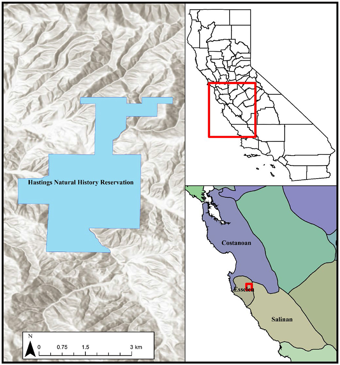
Figure 1. Overview map with the boundaries of the Hastings Natural History Reservation. (Upper inset) California boundaries with the extent of the lower inset map shown. (Lower inset) Overview of California Native Tribal territories with the extent of the Hastings Reservation.
In 2021, the Hastings Natural History Reservation planned to remove a stream barrier to facilitate the spawning migration of anadromous steelhead populations within the Carmel River and its tributaries. The project sought to support steelhead populations through the addition of a new bridge, but it required an assessment of the potential impacts on natural and cultural resources. This initial cultural resource management project brought together our collaborative research team.
At the request of Dr. Jen Hunter, Director of the Hastings Natural History Reservation, Sanchez and Apodaca initiated the background research for the project by conducting a records search through the Northwest Information Center, Sonoma State University, to identify all known and previously recorded cultural resources located on the property. We also reviewed previous archaeological reports by Breschini and Haversat (2012) summarizing findings of archaeological research conducted on the reserve in 1973 under the direction of Donald (“Digger Don”) Howard and members of the Monterey County Archaeological Society, which included a young Gary Breschini. The records search identified three archaeological sites within the reserve: CA-MNT-54, CA-MNT-55, and CA-MNT-56. All three sites are located east and northeast of the proposed project area. The closest sites, CA-MNT-54 and CA-MNT-56 are within 0.11 km of the proposed project.
Based on these findings, initial consultation with the Esselen Tribe of Monterey County began. Tribal Council supported the bridge project, the protection of Carmel River steelhead, and the opportunity to access and contribute to the protection of cultural heritage at the Hastings Reservation. While the records search identified several sites on the property, little was known about these sites based on archaeological reports due to the coarse-grained excavation strategies, lack of radiocarbon dating, and the expedient nature of the early excavations conducted by archaeologists, especially Don Howard, a known looter in the broader central California coast.
Through initial discussions, our collaborative research team agreed to several conditions that would guide all aspects of the field research: (a) the Esselen Tribe of Monterey County has the final decision-making authority related to their cultural heritage; (b) Tribal members would be included in all phases of the field research; (c) Tribal Council would be updated about every phase of the fieldwork (i.e., surface survey, geophysics) and would approve any subsequent phase of the project; and (d) low-impact field methods would be applied throughout all aspects of the project. As part of our 2021 project, Tribal Vice Chair Cari Herthel participated in the field research with field visits by Jana Nason. In addition, several meetings occurred throughout the field season with the Tribal Council for review, modification, and approval of all field research.
In 1973, Don Howard and Monterey County Historical Society members conducted expedient and course-grained archaeological excavations at CA-MNT-54, CA-MNT-55, and CA-MNT-56. Excavations included one 4 × 4 ft excavation unit at CA-MNT-54, four or five (exact number unknown) 5 × 5 ft units, and one 2.5 × 10 ft excavation trench at CA-MNT-55 and appear to have collected materials from the surface at CA-MNT-56 (Breschini and Haversat, 2012). Excavations were conducted using in mesh sieves with units excavated in six-inch arbitrary levels. Unfortunately, the materials from these excavations were never formally analyzed, although Breschini and Haversat (2012) reported a summary of the excavations while preparing the original excavation materials for long-term curation. We are very fortunate for the work of Breschini and Haversat (2012) in preserving some documentation of the research that occurred at the Hastings Reservation.
Breschini and Haversat (2012) summarize that 103 artifacts were recovered from the three sites. The temporally diagnostic artifacts, such as a Callianax biplicata G2 type bead, suggest an occupation between AD 445–575 (Milliken and Schwitalla, 2016). Based on the midden constituents, including diverse marine shellfish, faunal remains, and lithics, Breschini and Haversat (2012) interpret the three sites as villages.
The Esselen Tribe of Monterey County has a deep knowledge of the Upper Carmel Valley, including the Hastings Reservation and its history. Within the study area, it is the perspective of the Esselen Tribe of Monterey County that the Santa Lucia Mountains was a space that interconnected Esselen tribes, including the Excelen, Eslenejan, Ecgeajan, Imunajan, and Aspasniajan and various neighboring Tribes including the Chalon, Salinan, and other communities. While the Ecgeajan are associated with the Big Sur Coast, the Excelen are known to have occupied the Upper Carmel Valley, the Imunajan were to the east along the Arroyo Seco (Cuchun), the Eslenejan were north of Mission Soledad, and the Aspasniajan was south (Shaul, 2019). Therefore, large portions of Esselen territories were occupied inland, away from the coastline, and into the Salinas Valley.
The Excelen and Rumsen, due to their proximity to Mission San Carlos, were among the first Tribes of the area to be forced into the missions (Breschini and Haversat, 2004). However, as Tribal Vice Chair Cari Herthel shares, the sites at the Hastings Reservation represent pre- and post-Spanish Mission period occupations, where families, specifically women and children, sought refuge and evaded the mission system, soldiers, and other colonial authorities. Therefore, the Upper Carmel Valley, including the Hastings Reservation, is considered an important place of refuge for the Tribe due to its rugged and remote mountains that provided refuge from Spanish missionaries and soldiers (Breschini and Haversat, 2004; Schneider, 2015, 2010; Schneider and Panich, 2019). These Esselen perspectives are supported by historical documents from 1782 when Governor Filipe de Neve wrote:
“The repeated patrols that have been sent out to importune them [runaway Indians] to come back have resulted in deaths among the non-Christian natives, due to the poor supervision of the officers in charge. I have refrained to the greatest extent possible from sending out these patrols, preferring other methods for returning runaways to their missions. In those situations in which it has been unavoidable to send them, it has been done with the most detailed instructions to avoid lamentable consequences. It was as much a danger to the little parties which the Presidios were able to send into the mountains where the natives took refuge. There was little that our troops could do in that rugged, rocky country, which obliged the soldiers to dismount and enter villages on foot. The non-Christian natives are coming to understand our small number and weakness faster and more frequently.” (Milliken, 1990, p. 56)
It is clear from these statements that the Esselen were striving to avoid Spanish persecution and capture while also being faced with ongoing Spanish brutality. However, instances of resistance to Spanish colonialism are also recorded. For example, Pedro Fages documented (Geiger, 1959, p. 394),
“The Indians of the Sierra de Santa Lucia between San Carlos and San Antonio Missions molested the mission at times as well as the Christians and nearby Pagans. Resistance also came from Indians in the present area of Castroville, where the Salinas empties into the Bay of Monterey; Fages declared the area was inaccessible to those who lived in Monterey. The Sierra Indians could not be easily punished since when they were pursued, they went further into the mountains.”
Within a dozen years after the Spanish arrived, it had become dangerous to send the small parties of soldiers “into the mountains where the natives took refuge” because the soldiers could not make full use of their horses “in that rugged, rocky country” (Breschini et al., 2004).
Further insights into Esselen villages, perhaps within the study area, are also gleaned from historical documents. For example, the project area may be associated with the Excelen village of Yppimegesan (Breschini et al., 2004; Breschini and Haversat, 2004). Information about Yppimegesan is recorded on June 24th, 1789, with the baptism of Piguane, otherwise known as Francisco Antonio, in baptismal records; see San Carlos baptism record 1,422 that occurred at this village 2 days before his death (Hackel, 2022). Piguane's birthplace is noted as Yppimegesan (or Yppime) de los de Escelen. These records provide insights into the location of Yppimegesan stating, “en el parage llamado Yppime…rumbo al oriente y distante de los Tulares como tres leguas.” As noted by Breschini and Haversat (2004) this village would likely be east of Cachagua Creek in the Upper Carmel Valley, along Finch Creek in the general area of Jamesburg and the Hastings Reservation.
From the perspective of the Esselen Tribe of Monterey County, there is evidence of habitation sites so remote in the Santa Lucia Mountains that they are hard to locate today. Some of these sites and ancestral remains from the Mission Period have been recorded and discussed (Breschini et al., 2004), while others have not been recorded yet. For example, archaeologists have documented the ancestral remains of one individual, a girl of about 6 years of age, who was buried in the mountains with preserved sheep and deer skin found in three associated caches. These deposits are clearly historic. Based on shell and glass beads buried with the child, the date attributed to this burial was approximately AD 1825 (Breschini et al., 2004). Thankfully, some of the captured Esselen survived this brutal tragedy and continued to survive until the Spanish Missions fell into disuse after the Mexican Revolution.
For the Esselen Tribe of Monterey County, the Upper Carmel Valley, the Santa Lucia Mountains, the Sierra de Salinas, and Arroyo Seco represent an interchange that links the Esselen, Chalon, and Yokuts, bringing together the Esselen to the west, the Chalon and Yokuts to the east, north, and south, respectively. These spaces served as trade corridors linking the Esselen to the west, the Chalon, and the Yokuts into San Benito County. These diverse cultural connections are especially important at Mission Soledad and have been passed down through oral history. From this perspective, the Upper Carmel Valley and Arroyo Seco interconnect the Esselen and Chalon peoples, serving as a highway linking the east and west, and these interconnected communities are joined through familial lineages.
To the east of the Upper Carmel Valley in the Salinas Valley lies Mission Soledad. It is recognized that Mission Soledad was built in Esselen and Chalon territory (Farnsworth, 1987). Early researchers all placed Mission Soledad within Costanoan territory, but studies (Breschini and Haversat, 2004; Levy, 1978), have corrected the boundary in this area. In fact, the mission was founded at the Esselen village of Chuttesgilis. For the Tribe, the connection to Esselen is clear. However, the Tribe recognizes the cultural diversity present at Mission Soledad.
As Tribal Vice Chair Cari Herthel shared, around 1929, C. Hart Merriam also placed Chuttesgilis at Mission Soledad. Also, Padre Junipero Serra wrote a letter in 1774 when he named the newest mission, Soledad, named for an Esselen woman. According to Mission records from San Carlos, “Maria Balbanera (CA-B 1625) is reported to have the Indian name “Soletaces” or “Soledases” being noted as originating from “Escelen, rancheria de Eslenajan” the area in and around modern-day Soledad (Breschini and Haversat, 2004; Hackel, 2022). Junipero Serra outlines the origin of Soledad on August 24, 1774, writing to Antonio Maria De Bucareli y Ursua:
The origin of the name Soledad was as follows: when, three years ago, I came back from the foundation of San Antionio, I passed the night in that place. On my arrival there, in the evening, some gentiles approached us bringing presents of seeds ready to eat. I accepted them, gave them some glass beads, and was engaged in making friends with them when they asked me, by signs, if I would allow some women who were close by, to be presented…and of the one who came forward with a present, I asked her name, as I knew that expression in their language. She answered me, as I understood: “Soledad.” I was astonished, and turning to my companions said: “Here gentleman, you have Maria de la Soledad!” (Tibesar, 1955, p. 141).
Currently, there are no intensive cultural surveys of the Santa Lucia Mountains and the Sierra de Salinas. Tom Little Bear Nason, Chair of Esselen Tribe of Monterey County, knows of numerous water sources in the mountains above Soledad as well as flatlands, such as “the Basin” that would have supported interior villages. Little Bear lived on Palo Escrito Ranch [near Hastings] in the 1970s with his sister, Gail. He recalls riding the trails across Palo Escrito and Basin Ranches in the 1980s with his father, Fred Watson Nason, and his brother, Fred Lambert Nason, mending fences and tending cattle for the Gianolini family, a Swiss family who owned the Basin Ranch. As a result of his experience on the land, Little Bear predicts an intensive survey of the land will reveal gathering and processing sites, along with well-worn trails connecting people with the coast. His expertise will be invaluable in the survey.
Little Bear recalls how it was not possible to get livestock to the Salinas Valley from the interior of Carmel Valley down through the Arroyo Seco River because of the steep cliffs were impassable. Instead, ranchers used the trails that crossed over the Sierra de Salinas from east Carmel Valley Road, once called Jamesburg Road [near Hastings] at the eastern end. He remembers that in those days, that road was not an option for driving livestock. Little Bear remembers the network of trails leading to places where travelers could lay over on their trips to and from the coast. He recalled that the Basin area is abundant with wildlife and water. The “truck trails,” such as, one at Rana Creek, Sand Creek Road, Paloma Ridge Truck Trail, Sanchez Road, and Big Bend Road, go up into the Sierra de Salinas, where dirt trails heading north and south across these lower ranges of “the Basin” and into Carmel Valley and the Santa Lucias. Little Bear recalled stories about the outlaw Tiburcio Vazquez, who used this area to escape the Salinas Valley plain through the Indian Valley trail at Paraiso Hot Springs. Not only the Gianolini family but also the Cahoon family, the Koester family, the Reed family, and the Sunkler family used those trails to go through the mountain range, following the Indian trails to get their livestock to the Salinas Valley to the train depot. The examples provided by Esselen cultural landscape knowledge indicate their unsung role in the regional development of the cattle industry.
In June 2021, we conducted archaeological research at CA-MNT-54, CA-MNT-55, and CA-MNT-56 and conducted a pedestrian survey and augering at the proposed stream barrier removal area. To establish site boundaries, depth of deposits, and integrity, we conducted a pedestrian survey, catch and release surface survey, magnetometry, and ground-penetrating radar at CA-MNT-54, CA-MNT-55, and CA-MNT-56 to re-establish the site boundaries. During this surface survey, we identified two previously unrecorded archaeological sites near CA-MNT-55 (Figure 2).
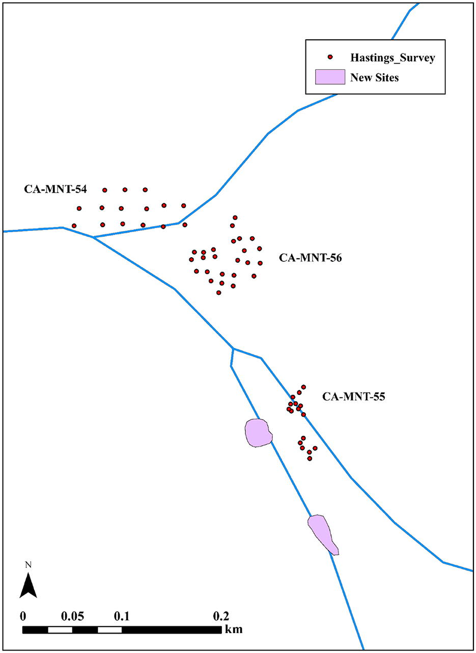
Figure 2. Placement of surface survey units and location of previously unidentified archaeological sites at Hastings Natural History Reservation during the 2021 field season.
Our surface survey and catch-and-release survey strategy, which includes 50 surface survey units, follow the low-impact methodology outlined by Lightfoot (2008), Gonzalez (2016), and Sanchez et al. (2021). The field methodologies involve several stages. First, researchers begin by comprehensively mapping the site(s) via topographic maps, digital elevation models, and/or terrestrial and aerial Light Detection and Ranging (LiDAR), using preexisting data and supplementing these datasets when necessary.
Second, researchers establish a systematic grid system to conduct an intensive surface collection of archaeological materials with standardized sampling, recovery, and quantification strategies. As part of our surface survey strategy at each surface survey unit, we created a 50 cm radius circle applying the “dog-leash” method (Binford, 1964) from each unit datum to establish the unit's boundaries (Gonzalez, 2016; Lightfoot, 2008; Sanchez et al., 2021). Next, field crews removed surface vegetation within their unit to expose cultural materials. Then, crews collected 3 L of soil sampling equally from all unit sections to ~1 cm depth. The 3 L were screened using 1/8″ mesh soil sieves, and all cultural materials were sorted, counted, weighed, and recorded in situ. After each unit was analyzed, cultural materials were returned to their respective units. These data were used to create isopleth density maps to reveal cultural material concentrations (i.e., shellfish remains, faunal remains, lithics, and fire-cracked rock), thereby identifying areas where food processing and other activities may have occurred, habitation features, and areas with a high potential to yield dense and diverse subsurface archaeological deposits, see Sanchez et al. (2021) for isopleth density map production.
Third, researchers use the data from the previous phases to place geophysical survey grids, including ground-penetrating radar, magnetometry, and electromagnetic resistivity, especially in locations where surface survey units yielded the highest densities. Based on the surface survey results and density estimations, we established six ground-penetrating radar grids to investigate locations that appeared to represent dense shell midden deposits. We established four 10 × 10 m grids at CA-MNT-54, one 20 × 10 m grid at CA-MNT-55, and one 20 m × 6 m grid at CA-MNT-56.
The ground penetrating radar grids were surveyed using the following methods and procedures. All transects were initiated from the unit's southwest corner, with transects running north (odd numbers) and south (even numbers). For our survey, the RDP (dielectric) was 7.6. The soil was dry, so we had good data (i.e., little signal noise) to 1.5 m. We surveyed at three transects per meter (33 cm transect spacing) for higher resolution than the standard 2/m, with the transect distance measured by a calibrated survey wheel. We used a GSSI SIR4000 with a 350 MHz antenna in both tow-handle and three-wheel cart configurations. Ground-penetrating radar grids were post-processed in the GPR Slice Program (Version 7.MT), and individual transect profiles “radargrams” were processed in GPR Viewer (Version Beta 1.8.5) and included the use of a background filter to remove ambient regional interference.
In the final stage of the low-impact archaeology approach, collaborators integrate the findings from previous phases and work together to identify locations for subsurface excavations where potential intact features and dense midden deposits may occur while avoiding sensitive features such as human and nonhuman burials and other sacred objects.
Of the 50 surface survey units we sampled, analyzed, and quantified at the Hastings Reservation, only units at CA-MNT-55 produced dense and diverse cultural materials. CA-MNT-54 and CA-MNT-56 had much lower densities overall, especially compared to the lithic and faunal densities (Figures 3, 4). For example, seven of the 10 units surveyed at CA-MNT-55 contained lithics. At CA-MNT-55, the weight of lithics ranged from 0.2 to 142.2 g. At CA-MNT-54, only five of the 15 units contained lithics ranging from 0.3 to 13.1 grams. At CA-MNT-56, of the 25 units surveyed, only four contained lithic materials ranging from 0.4 to 50.2 g. The lithic materials encountered at these sites represented Monterey chert, flaked quartz, and obsidian.
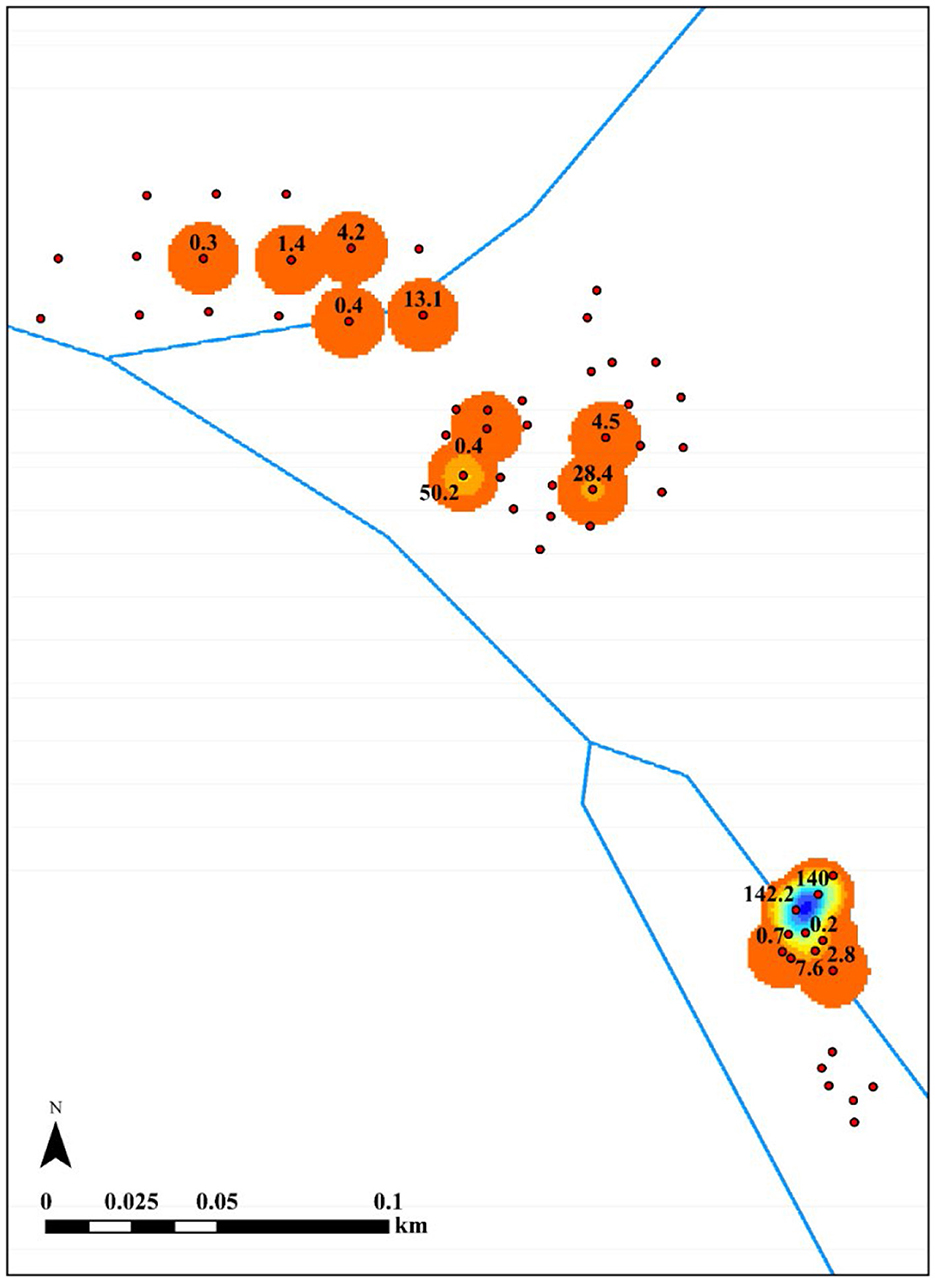
Figure 3. Lithic density by weight.
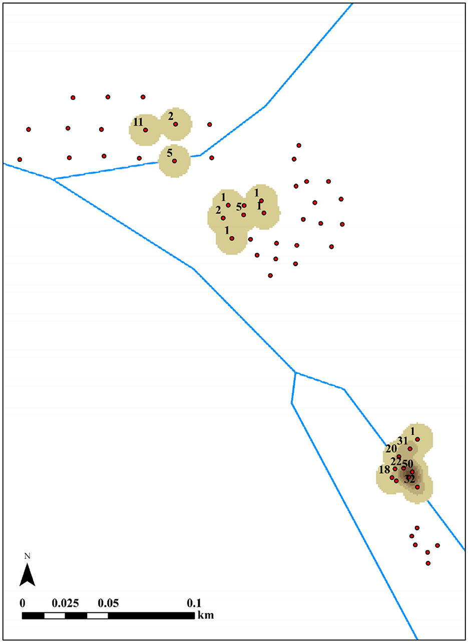
Figure 4. Faunal density by NISP.
We recognize limitations in representing our materials classes (e.g., fire-cracked rock, shellfish, and lithics) by weight rather than count (Gifford-Gonzalez and Hildebrandt, 2012). Our 2023, field strategy incorporated counts and weight, but the data in this report is limited to weight for lithics, shellfish, and fire-cracked rock. However, as the 2021 surface survey methodology was designed to locate potentially dense midden deposits expediently, we used weight to accomplish the goal of locating dense and diverse deposits to guide subsequent research phases.
To assess our findings from the lithic density analysis, we also quantified the presence of faunal remains by the number of identified specimens (NISP) at each site. For example, eight of the 10 units surveyed at CA-MNT-55 contained animal bones (Figure 4). At CA-MNT-55, the NISP of animal bones ranges from 1 to 52 NISP. At CA-MNT-54, only three of 15 units contained animal bones ranging from 2 to 11 NISP. At CA-MNT-56, of the 25 units surveyed, six contained animal bones ranging from 1 to 5 NISP. Therefore, our findings from the surface surveys highlight the high densities of cultural materials at CA-MNT-55 when compared to CA-MNT-54 and CA-MNT-56.
We recognize that CA-MNT-54 and CA-MNT-56 have been impacted more by historical disturbances than CA-MNT-55. For example, CA-MNT-54 was trenched and bisected by underground utility lines added to the reservation to support the UC facilities and infrastructure. The gradiometer and ground-penetrating radar surveys confirmed these findings. CA-MNT-56 has also been severely impacted by road construction and other infrastructure related to the reservation and neighboring properties. The faunal and lithic data corroborated these trends, revealing high densities of materials at CA-MNT-55.
Given the high density and diversity of cultural materials at CA-MNT-55, we established one ground penetrating radar grid measuring 20 × 10 m where cultural materials appeared the densest. While we conducted additional grids at CA-MNT-54 and CA-MNT-56, those results are not presented in the following.
The ground-penetrating radar survey of grid 5 resulted in 31 transect files (files 125–156), which begin in the southwest corner (0N/0E); therefore, transects represent the Y-axis. Our survey identified a potential feature, but the overall ground-penetrating radar survey results were inconclusive. After communicating these results with all collaborators, we selected the potential feature, which was located in a portion of the site with high densities of cultural materials because the area had higher amplitudes in the majority of amplitude slice maps.
Based on the surface and ground penetrating radar survey findings, our research team decided to place one excavation unit at CA-MNT-55 to ground truth the possible feature and/or intact midden deposits that were possibly identified during the ground penetrating radar survey. One 1 m × 1 m excavation unit was placed within ground penetrating radar grid 5. Through discussions among our collaborative team including Tribal Council, it was agreed we would begin our field program with limited excavation and proceed with further fieldwork in the future based on the results of our initial findings, see above. We placed the southwest corner of excavation unit 1 (EU1) 5 m north and ~3 m east of the southwest corner of the GPR grid in an attempt to sample the southern portion of the potential feature. Byram interpreted this portion of the grid as possibly containing intact deposits from 40 cm to 1 m depth.
As previously mentioned, we identified high densities of artifactual materials at the site during the catch-and-release surface survey, and the GPR data suggested the possibility of high densities of cultural material below the surface. The ground-penetrating radar survey identified potential features represented by high-amplitude areas and hyperbolae in amplitude slice maps and individual transect files. Therefore, EU1 was placed in a high-amplitude area that may represent a feature.
The excavation and ground-truthing of the unit produced various materials, including dense concentrations of fire-cracked rock, faunal remains, lithics, and temporally diagnostic artifacts. Seven levels were excavated in the unit, which terminated 70 cm below datum (bd) as sterile sediments occur at or below these depths. However, the densities of cultural materials dropped significantly between level 6 and the termination of level 7. Two 10-L sediment samples (20 L total; 10-L samples each recorded by sample level and designated A and B) were sampled from each excavation level.
The unit included dense cultural deposits dominated by fire-cracked rocks that included evidence of rodent bioturbation throughout every level. However, no intact features were encountered, such as the remnant hearths of earth ovens. We interpreted these trends to represent a secondary deposition of hearth or earth oven constituents, including fire-cracked rock, artifacts, lithics, faunal remains, and paleoethnobotanical remains.
We submitted eight samples for radiocarbon dating, including carbonized plant remains (n = 4) and animal bones (n = 4). We attempted to submit paired plant remains and animal bones where feasible to construct our site chronology. This included samples from levels 2, 3, 5, and 7. These samples were submitted to the W.M. Keck Carbon Cycle AMS Laboratory, University of California, Irvine (UCIAMS) for AMS radiocarbon dating.
At UCIAMS, radiocarbon was extracted and purified from carbonized plant remains and animal bone samples. Radiocarbon samples representing charred plant remains, primarily single specimens of Fabaceae, Cyperaceae, and Poaceae seeds, were treated with acid-base-acid (ABA-−1N HCl and 1N NaOH, 75°C) prior to combustion to remove humates. Radiocarbon ages were corrected for mass-dependent fractionation with measured δ13C values on the AMS and compared with samples of 14C-free wood. All 14C ages were calculated according to Stuiver and Polach (1977).
At UCIAMS, bone collagen was extracted and purified using the modified Longin method with ultrafiltration (Brown et al., 1988; Hoggarth et al., 2014). Samples (200–400 mg) were demineralized for 24–36 h in 0.5 N HCl at 5°C, followed by a brief (< 1 h) alkali bath in 0.1 N NaOH at room temperature to remove humates. The pseudomorph was rinsed to neutrality in multiple changes of 18.2 MO H2O, and then gelatinized for 10 h at 60°C in 0.01 N HCl. Gelatin solution was pipetted into precleaned Centriprep130 ultrafilters (retaining >30 kDa molecular weight gelatin) and centrifuged three times for 20 min, diluted with 18.2 MO H2O, and centrifuged three more times for 20 min to desalt the solution. More detailed ultrafilter cleaning methods are described by McClure et al. (2010). Ultrafiltered collagen was lyophilized and weighed to determine the percent yield as a first evaluation of the degree of bone collagen preservation. All δ13C and δ15N values were measured to a precision of < 0.1 and < 0.2‰, respectively, on aliquots of ultrafiltered collagen, using a Fisons NA1500NC elemental analyzer/Finnigan Delta Plus isotope ratio mass spectrometer. Sample quality was evaluated by % crude gelatin yield, %C, %N, and C:N ratios before AMS radiocarbon dating. C:N ratios for the successful samples were 3.3, indicating good collagen preservation and within the threshold advocated for by DeNiro (2.9–3.6) and van Klinken (3.1–3.5) (DeNiro, 1985; van Klinken, 1999).
Radiocarbon samples (~2.5 mg) were combusted for 3 h at 900°C in vacuum sealed quartz tubes with CuO wire and Ag wire. Sample CO2 was reduced to graphite at 550°C using H2 and a Fe catalyst, with reaction water drawn off with Mg(ClO4)2 (Santos et al., 2004). Graphite samples were pressed into targets in Al cathodes and loaded on the target wheel for AMS analysis. Radiocarbon ages were corrected for mass-dependent fractionation with measured δ13C values on the AMS (Stuiver and Polach, 1977) and compared with samples of 14C free whale bone and mammoth bone.
Of the eight samples submitted, two bone samples, one from level 2 and one from level 5, dissolved during pretreatment and were not analyzed by UCIAMS (Table 1). Two additional botanical samples, UCIAMS #260806 and 260807, were modern as they contained excess 14C, probably from mid-20th century thermonuclear weapons tests (Reimer et al., 2004). Calibration of the samples confirms that the fraction modern or F14C (260806 F14C = 1.0714 ± 0.0022 and 260807 F14C = 1.2764 ± 0.0024) are modern. Therefore, these samples are consequently excluded from chronological modeling (Reimer et al., 2004; Reimer and Reimer, 2004). δ13C for the single mammalian remain is consistent with terrestrial fauna therefore we used terrestrial calibration models for all dates, reported below (Reimer et al., 2020).
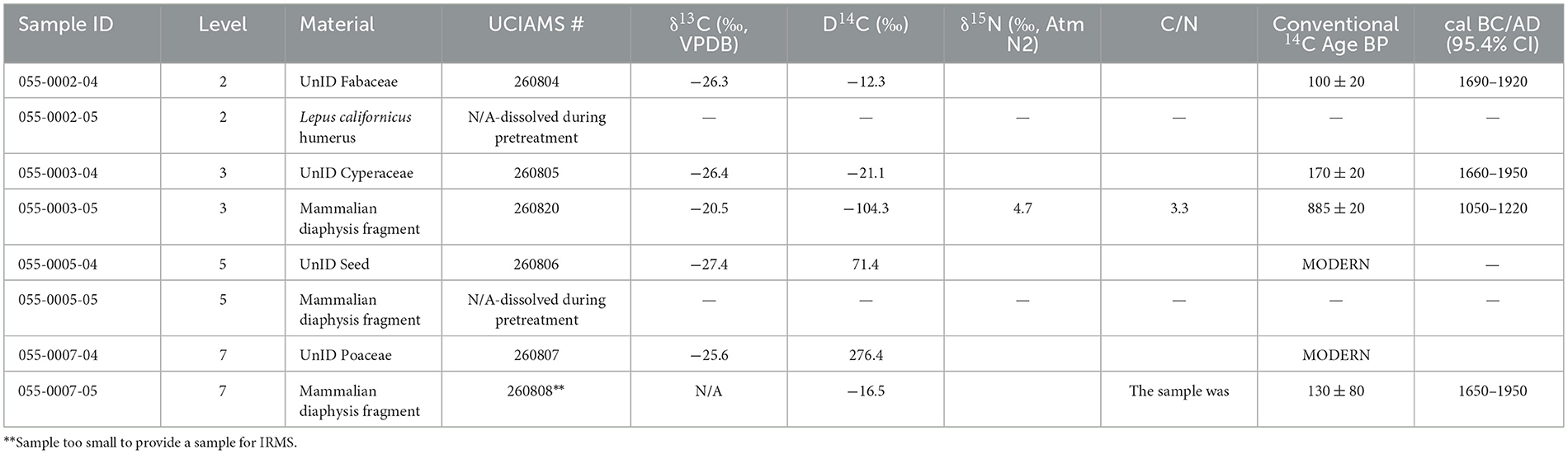
Table 1. CA-MNT-55 material, context, and conventional and calibrated AMS 14C dates.
The remaining four samples were calibrated based on their context within EU1. In calibrating the samples, we assumed that all deposits were in undisturbed stratigraphic order. To test this assumption and the stratigraphic integrity of the site and radiocarbon samples, we initially created a simple calibration model and sequence for the site. Radiocarbon dates were placed in a sequence in OxCal with boundary start and end dates calculated. The large uncertainty for the UCIAMS# 260808 sample is due to the very small sample size. This sample was too small to provide an extra aliquot of CO2 for IRMS stable isotope measurements.
The sequence and initial calibration of the model results in problems with the modeling likely driven by a stratigraphic reversal, as seen in UCIAMS# 260820 in level 3 (Figure 5 and Table 2). For example, the agreement indices for the model are Amodel = 0% outside the tolerance suggested by Bronk Ramsey (1995). These issues are likely driven by the stratigraphic reversals in the unit. As Bronk Ramsey (1995) notes, model agreement indices should not fall below 60%. If the model agreement index falls below 60% (analogous to a 0.05 significance level in a Chi-square test), the radiocarbon results or the models are problematic.
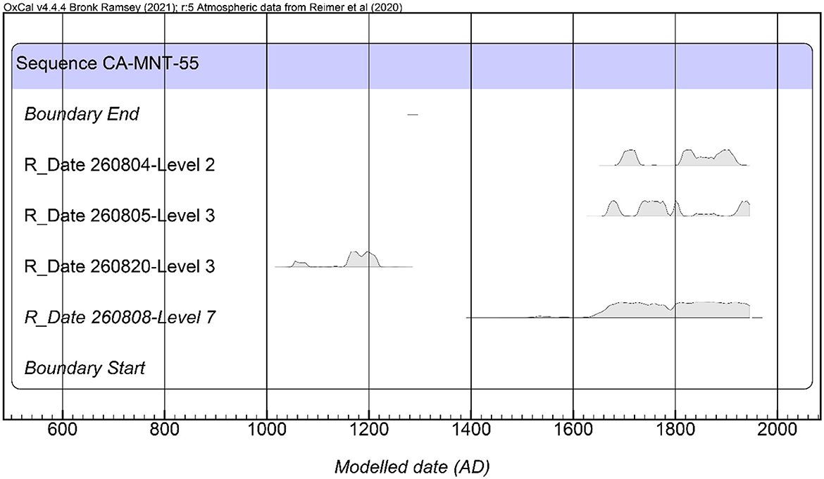
Figure 5. Model 1 results. Radiocarbon dates organized stratigraphically in sequence.
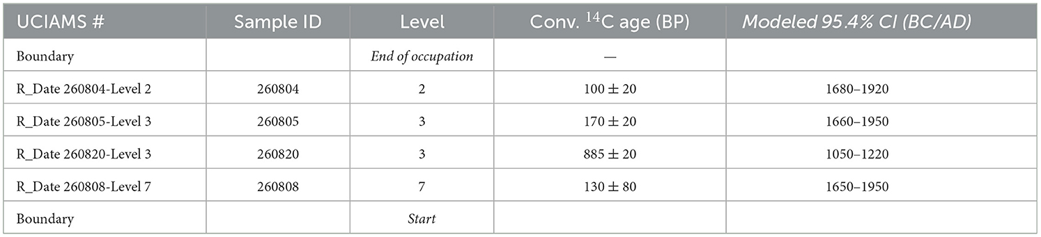
Table 2. Unit 1 radiocarbon dates, including modeled sequence, 95% probability ranges, and boundaries.
Based on these results, in the second phase of modeling, we removed sample UCIAMS# 260820, as it likely represents “old bone” within the unit that may have resulted from evidence of earlier occupations at other portions of the site, bioturbation, early excavations at the site, or other disturbances. The three remaining samples were derived from mammal bone level 7, charred botanical level 3, and charred botanical level 2. The agreement indices for the model are Amodel = 87.3 and Aoverall = 88 within the tolerance suggested by Bronk Ramsey (1995). No statistically significant stratigraphic reversals are present in the unit based on the three samples. The units modeled sequence suggests a possible start of occupation between cal AD 810–1890 and ending around cal AD 1680–1950 with modeled radiocarbon dates from the basal and upper components of the midden spanning 1630–1880 to cal AD 1690–1930 (Figure 6 and Table 3). These dates place the site occupation from before, during, and after the Spanish Mission period.
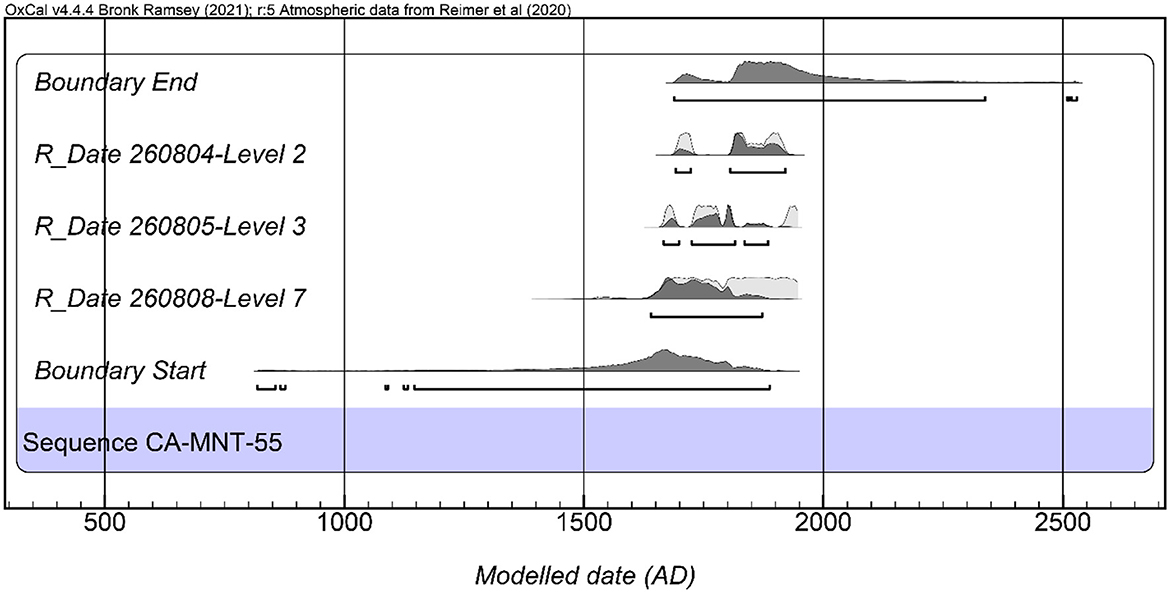
Figure 6. Model 2 results. Radiocarbon dates organized stratigraphically in sequence.
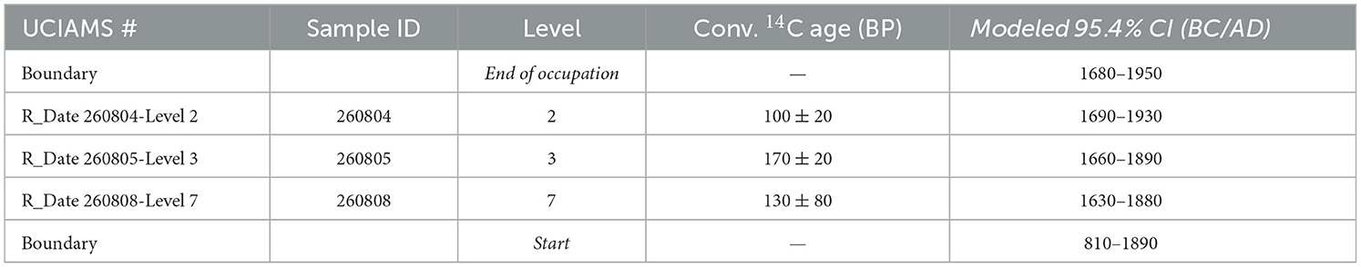
Table 3. Unit 1 radiocarbon dates, including modeled sequence, 95% probability ranges, and boundaries.
Apart from the radiocarbon dates, our excavations recovered five temporally diagnostic artifacts, including two Callianax biplicata shell beads, one clam bead, and two stone beads (Figures 7A–E) that further confirm a pre-European contact and Mission period occupation. All Callianax beads were recovered from level one of the excavation unit. The first Callianax bead (Figure 7A) represents a Spire-lopped bead (Class A) (Milliken and Schwitalla, 2016). At its widest diameter, the bead is 7.2 mm, and the length is 9.17 mm. The spire-end removal is normal; the spire-end perforation is small and ground. It is ground to the end of the spire suture line and retains the body whorl. Based on these metrics, it appears the bead represents an A1b Medium Spire-lopped bead (Milliken and Schwitalla, 2016).
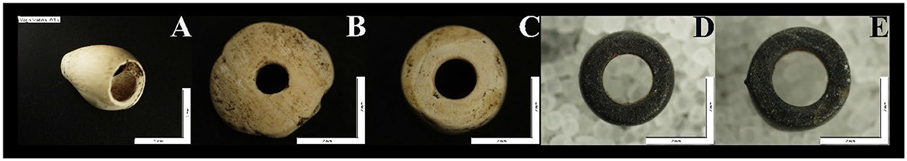
Figure 7. Callianax biplicata shell beads (A, B), one clam bead (C), and two stone beads (D, E) from CA-MNT-55.
The second Callianax bead (Figure 7B) represents a Needle-drilled Disk (Class H). The bead width is 4.29 mm, and its thickness is 1.21 mm, with a perforation size of 1.3 mm. While similar to Class G Saucers, the Class H beads are differentiated based on the cylindrical perforations that are not typical of Class G beads. Based on its attributes, the bead appears to represent an H1b Semi-ground disk bead. As Milliken and Schwitalla (2016) note, Semi-ground disks may be distinguished from H1a Ground Disks by their slightly nicked edges (Figure 7B) and distinguished from H2 Rough Disks by rolled-grinding around the edges. They are also distinct from G1 Saucers and J1 Wall Disks because of their straight cylindrical perforations.
The last beads represent a single clam shell disk bead (Figures 7A, C) and two steatite or talc schist disk beads. Collectively, the beads recovered align with Jones (2003) research on the Big Sur Coast and Panich's (2014) research at Mission Santa Clara de Asís that attributed these bead types to the Late Period (cal AD 1250 to 1769) and Mission Period (post-1769). These findings align with data reported by Milliken and Schwitalla (2016) related to our Callianax bead assemblage. For example, the Spire-lopped beads have been used throughout much of the western US for 9,000 years. Therefore, they are less diagnostic temporally. In the case of the Needle-drilled disks these beads are temporally constrained from the late 1770s through the 1830s. Milliken and Schwitalla (2016) note that H1b Ground Disks are markers of the Late Mission Phase of the Historic Period, approximately AD 1800–1816, but individual beads probably occurred in mixed populations with H1a beads at least as early as 1790. However, collectively, the assemblage along this section of the central California coast most closely resembles Late Period and Mission Period (cal AD 1500–1830s) sites (Brown, 2024; Jones, 2003; Jones et al., 2022; Panich, 2014; Wahoff and York, 2000; Wiggins, 2016, 2022).
In this section, we report findings from the faunal and paleoethnobotanical analyses. All faunal materials reported in this study were derived from the 1/8″ dry-screened material, and future analyses will include the >4 and 2–4 mm heavy fraction samples.
In total, 505 L of screened material were analyzed in this study from levels 1–7. All faunal materials were washed prior to analysis to facilitate taphonomic and zooarchaeological analyses. The recovered faunal remains were identified using comparative collections from the Department of Anthropology, University of Oregon. Laboratory protocols and faunal identifications were conservative in identifying elements (Driver, 2011; Gobalet, 2001).
A dissecting stereomicroscope was used to discern diagnostic features that allowed the most exclusive taxon designation, usually a family. We follow Page et al. (2013) using scientific and common names for fish. Osteological and provenience data were recorded for each specimen, with the results cataloged in Microsoft Excel and quantified using the measure of the number of identified specimens (NISP) (Grayson, 1984; Lyman, 2008). In our taphonomic analysis, we follow (Fisher, 1995). Below, we present the vertebrate and invertebrate faunal data.
The zooarchaeological analysis of vertebrate remains resulted in the identification of 3,824 NISP identified to at least the class level (Table 4). The vast majority of the assemblage, or 3,623 NISP (94.7%), represents less identifiable mammalian remains from very small (e.g., rodents), small (e.g., rabbits), medium (e.g., coyote), and large (e.g., deer) mammals. Based on the morphology of the bone, it is likely that the majority of the fragment mammalian remains represent terrestrial fauna. Only three specimens of less identifiable bird bones (e.g., phalanges) were recovered, suggesting limited use of birds at the site. A large component of the assemblage represents fragments and less identifiable mammalian remains, with some evidence of butchery, chop marks, cut marks, fresh fractures, and anvil markings. In addition, 1669 NISP, or 44% of the assemblage, is burned, with at least three mammalian remains showing evidence of vitrification.
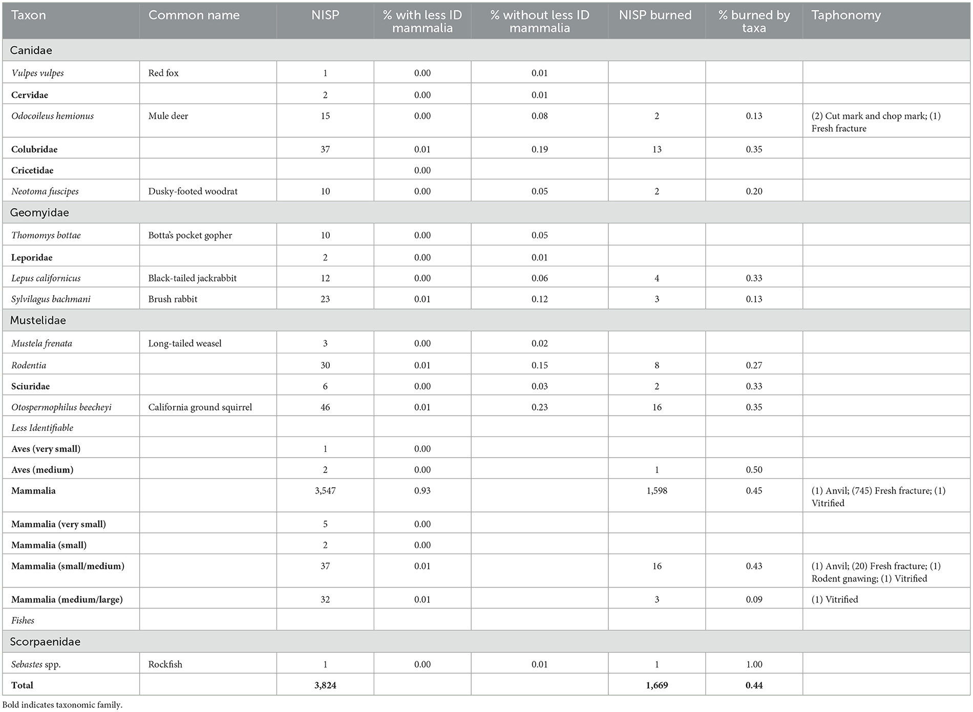
Table 4. Vertebrate faunas from CA-MNT-55 including NISP, relative abundance, NISP burned, percent NISP burned by taxa, and taphonomic results.
Of the remaining specimens, 198 were identified to the level of order or lower (Figure 8 and Table 4). The assemblage of more identifiable vertebrate fauna is dominated by mule deer (8%), leporids (19%) including black-tailed jackrabbit (6%) and brush rabbits (12%), Colubrid snakes (19%), Californian ground squirrels (23%), and rodents (25%), including dusky-footed woodrats (5%) and pocket gophers (5%), with less identifiable rodents representing (15%) a large portion of the assemblage. The remaining component of the assemblage is comprised of red fox (1%), less identifiable cervid (1%) remains, likely mule deer, long-tailed weasels (2%), Sciuridae (3%), likely less identifiable California ground squirrels, and rockfishes (1%).
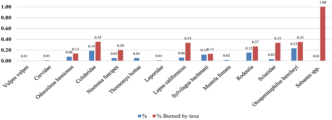
Figure 8. Relative abundance of vertebrate fauna from CA-MNT-55 with incidence of burning by taxa reported.
Nearly all fauna from the identifiable faunal remains demonstrate a high incidence of burning (NISP of taxa/NISP burned of taxa), especially mule deer (13%), Colubrid snakes (35%), dusky-footed woodrat (20%), black-tailed jackrabbit (33%), brush rabbit (13%), rodents (27%), squirrels (33%), and California ground squirrels (35%). Based on the taphonomic analysis, only mule deer demonstrate evidence of cut marks and fresh fractures beyond the evidence of burning described.
The invertebrate assemblage is comprised of five genera, including Haliotis spp., Balanus spp., Mytilus californianus, Tegula funebralis, and Nucella spp., and crustaceans that could not be identified beyond a general crab category (Table 5). However, all invertebrates represent marine species. The majority of the assemblage by weight is comprised of California mussels, representing 96% of the assemblage. These data on marine invertebrates at the Hastings Reservation are consistent with previous reports by Breschini and Haversat (2012).
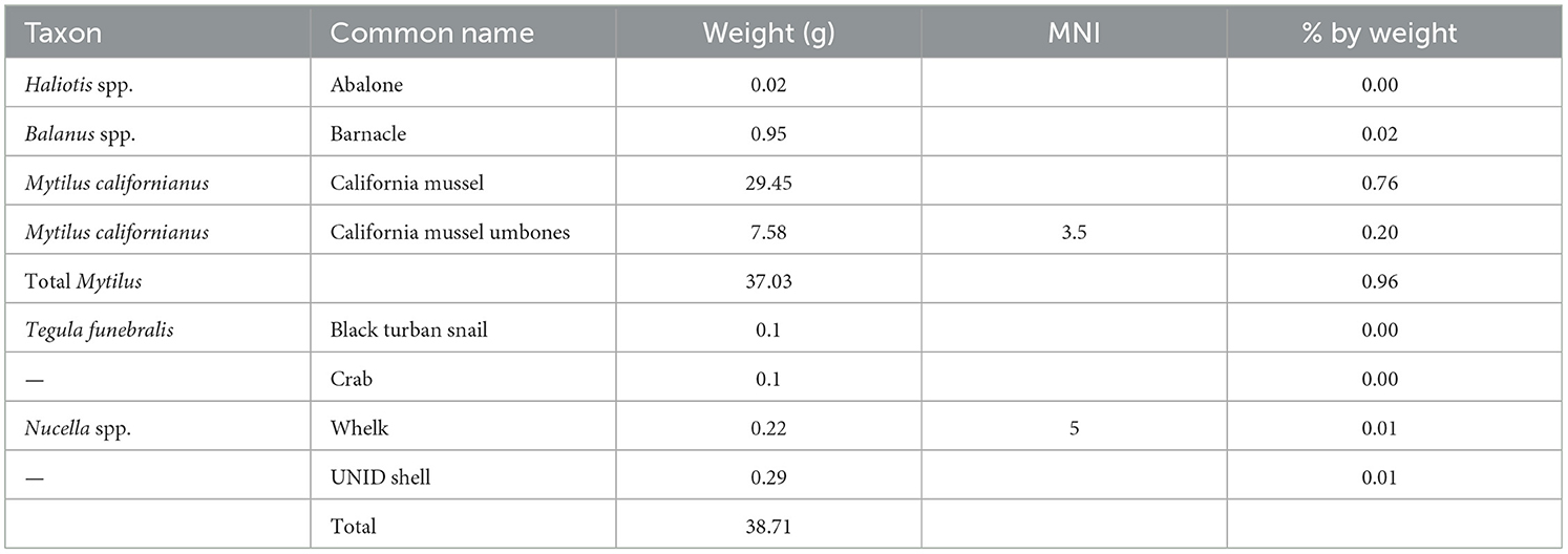
Table 5. Invertebrate assemblage from CA-MNT-55.
Examining the macrobotanicals from ~57 L of soil, the study provides a view of the ecofact plant assemblage from one 1 m × 1 m unit (EU1). This is an archaeobotanical pilot study of seven soil samples systematically collected from CA-MNT-55 from the starting surface of each arbitrary excavation level. Approximately two 10-L samples of soil were systematically collected from the center of each level, but only half of each sample (i.e., 10 L) was floated for macrofloral analysis, while the other half was curated for future studies.
After water flotation was used to extract buoyant archaeological materials from soil samples (see methods above for detail), each light fraction was sorted into five particle size classes for ease of identification efforts. The samples were passed through a nest of soil sieves creating >2, 1–2, 0.5–1, 0.3–0.5, and < 0.3 mm size classes and placed in labeled bags.
In the California Archaeology Lab at UC Berkeley, samples were processed by undergraduate apprentices with 0.5–1 years of eco-archaeological lab experience. Sorted samples and residuals were inspected by the authors. For the >2 mm subsample, all wood charcoal and carbonized plant remains were separated from the residual organic material, such as nutshells, seeds, and other woody or herbaceous tissues. For the 1–2 mm size fraction, all material classes above were sorted except wood charcoal. For 0.5–1 mm, only seeds (fragmented and whole) were selected. The 0.3–0.5 size fraction only focused on complete charred seeds and the < 0.3 mm fraction was omitted from the analysis. A seed was designated “IDable” when the seed contained some diagnostic attributes and was generally intact, meaning that a comparative study could be done to obtain taxonomic certainty. Seeds were designated “UNIDable” in the event the specimen was too poorly preserved or was highly fragmented so that a reliable taxonomic determination would be uncertain. Nutshell remains, such as acorns and buckeye, were counted and weighed. The seeds were only counted. Modern uncharred seeds were not counted and excluded from the analysis. In addition, the upper 0–10 cm soil sample was omitted due to the high number of modern debris in the sample.
Charred plant remains recovered from soil samples via water flotation are represented in EU1 at CA-MNT-55. The analysis of macrofloral constituents in the archaeological record also clarifies edible and potentially edible seed foods that may be collected at Indigenous sites in the interior Carmel River Valley. Furthermore, observations of the quantified data from systematically collected soil samples reveal information about site stratigraphic integrity, site use, and other ecological interactions at CA-MNT-55. The findings from the archaeobotanical study are expanded below.
Table 6 organizes the charred vegetal seed food remains from EU1, along with columns for count (n), nutshell weights (g), and recorded cultural uses. A total count of 124 charred macrofloral seeds were recovered from EU1 from CA-MNT-55. The most common identifiable seed with edible uses was acorn (Quercus sp.), and for small seed assemblage clover (Trifolium sp.), and Cheno-Mont (Chenopodioideae-Montiaceae).
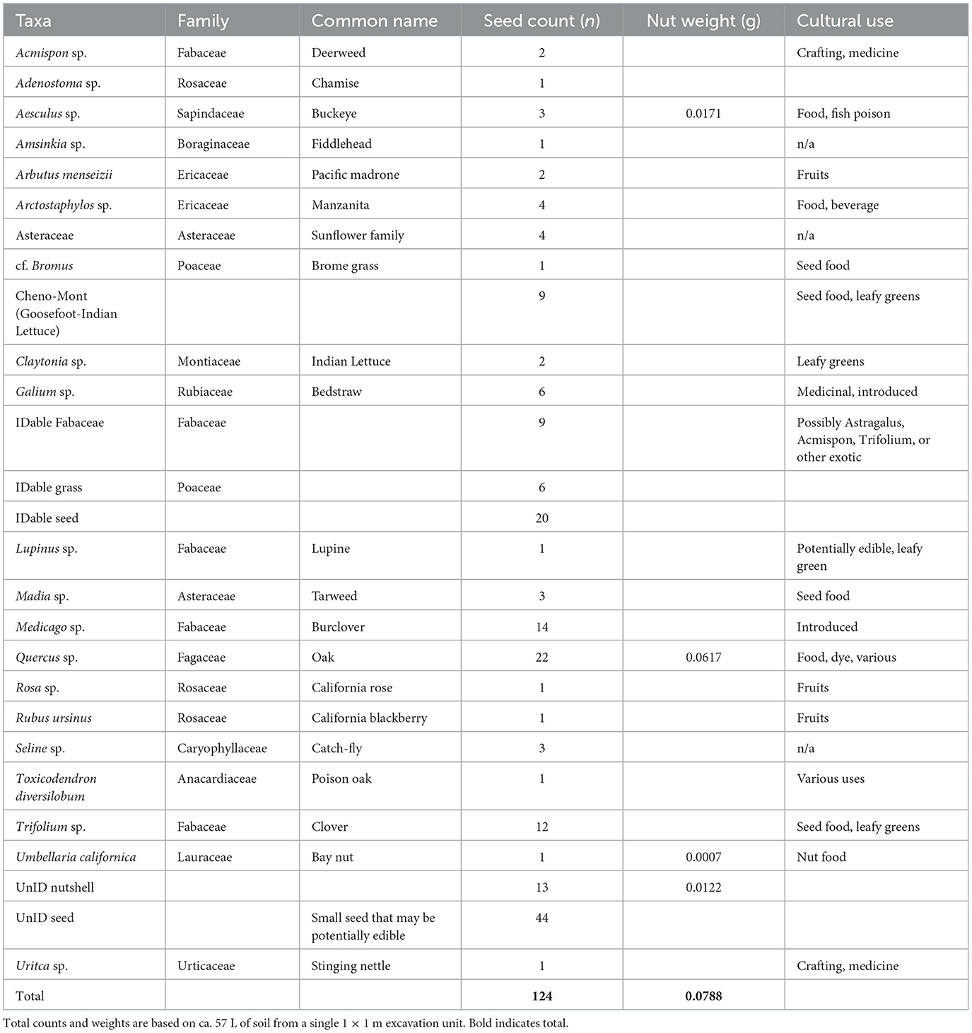
Table 6. Macrobotanical assemblage from CA-MNT-55.
There are at least five species of acorn-bearing oak trees that grow near the Hastings Reserve. The common oak species are Black oak (Quercus kelloggii), Coast Live Oak (Quercus agrifolia), Blue oak (Quercus douglasii), and Valley oak (Quercus lobata), which have potentially edible nuts and recorded ethnographic uses in California (Anderson, 2005). This diversity of species and similarities from small, fragmented acorns requires experimental fragmentation and microscopic identification of reliable features in the charred nutshell fragment. While no intact whole nutshells were collected, one charred involucre, which is consistent with blue oak or valley oak due to bumpy and warty texture, rather than smoother scales, such as Black oak or Coast Live oak. For these reasons, only a taxonomic level of the genus Quercus was provided.
Several seeds associated with edible fruits were recovered in low densities, but the most common consumption practice of those types of vegetal resources was eaten fresh and an inherently lower incidence of being burned from cooking. Elderberry and California rose, and California blackberry are food plants with cultural uses and occur near the site. Four charred manzanita nutlet fragments were recovered from EU1. Manzanita grows on the southern slopes facing above the site, and manzanita is a known food source for woodrats and other rodents. In addition, one charred cf. Bromus spp. seed was recovered in the site that was in near-perfect condition, which suggests a modern specimen rather than an archaeological specimen that has undergone cultural and natural taphonomy processes.
Analysis of soil samples also revealed that modern uncharred seeds occurred in each arbitrary level from the soil samples. During the sorting process, uncharred seeds and insect frass were not separated or counted, but only the presence of the species was noted. In Level 5, over 200 catchfly (Seline sp.) seeds were observed. Considering this context of the intrusive seeds, whose numbers far exceed those of charred seeds, there is reason to believe that rodent disturbances or some other form of bioturbation are evident in some of the levels, supporting the radiocarbon dating results, see above.
The preservation of wood and macroflorals can be qualitatively described as medium-to-poor. While seed integrity was not systematically recorded as part of this analysis, the granitic sandy soils present at the site may suggest that soil type has negatively impacted the preservation of archaeobotanical data at the site. Further sampling at additional sites may be conducted to better compare and understand the effects of local soil on the preservation of charred botanicals, such as the sandy loams encountered at CA-MNT-55.
Future sampling of soil for macroflorals should also include taking additional, smaller volume subsamples of areas perceived to not contain rodent tailings. While incorporating this technique is often constrained by the presence of identifiable rodent burrows, field time, experience of excavators, and design, collecting additional soil judgmentally of in-situ soils can help evaluate the extent of bioturbation to archaeological contexts from arbitrarily collected levels. It is for these reasons we elected not to overinterpret the microflora data beyond the evidence for acorn nut uses at CA-MNT-55.
Our lithic analysis of CA-MNT-55 includes the artifacts from the dry screen and 10-L bulk sediment samples recovered from each excavation level from EU1. The following outlines field and laboratory methods used to collect, process, and further analyze lithic archaeological samples. While the majority of the lithic analysis is focused on the flaked stone assemblage, we did recover one complete granitic pestle in our excavations, consistent with the granitic pestles recovered in previous excavations at the Hastings Reservation (Breschini and Haversat, 2012).
Lithic materials from flotation heavy fractions were sieved through 4 and 2 mm nested sieves, resulting in two size categories >4 and 2–4 mm size. The dry screen lithic material was sieved through a 3.2 mm mesh in the field. Lithic artifacts were individually weighed (grams) and measured (mm) for the maximum length, width, and thickness. Lithic artifacts within the 4, 3.2 (dry screen), and 2–4 mm (flotation) size classes that were identified as complete flakes and proximal flakes were also weighed and measured as described above.
All cultural constituents were sorted out after the material was size sorted with the help of a low-powered microscope. Lithics were then classified following Andrefsky (2005), Lightfoot and Gonzalez (2018), Silliman (2000), and Gonzalez and Field (n.d.). Our classification of chipped stone artifacts follows Andrefsky (2005) with slight modifications to classifications of debitage. Chipped stone artifacts were classified according to morphological characteristics and sorted into “tool” and “debitage” classes. Tools include core, biface, projectile point, and uniface. Cores can be defined as chunks of raw material, often derived from cobbles, from which flakes have been removed. Bifaces are formal tools that have been symmetrically shaped on both sides by flake removal, as opposed to unifaces, which have been systematically formed on one side. Projectile points are a specific kind of biface that may have been used as a dart or arrow point and usually exhibit notched corners.
The lithic analysis suggests a diversity of stone tool use, production, and maintenance occurred at the site. In terms of raw materials, we recovered basalt, chalcedony, Franciscan chert, granite, Monterey chert, obsidian, ochre, quartz, sandstone, and steatite. The formal tool assemblage was also diverse, with Franciscan chert cores, an obsidian core, and a Monterey chert biface, drill, and scraper recovered (Table 7).
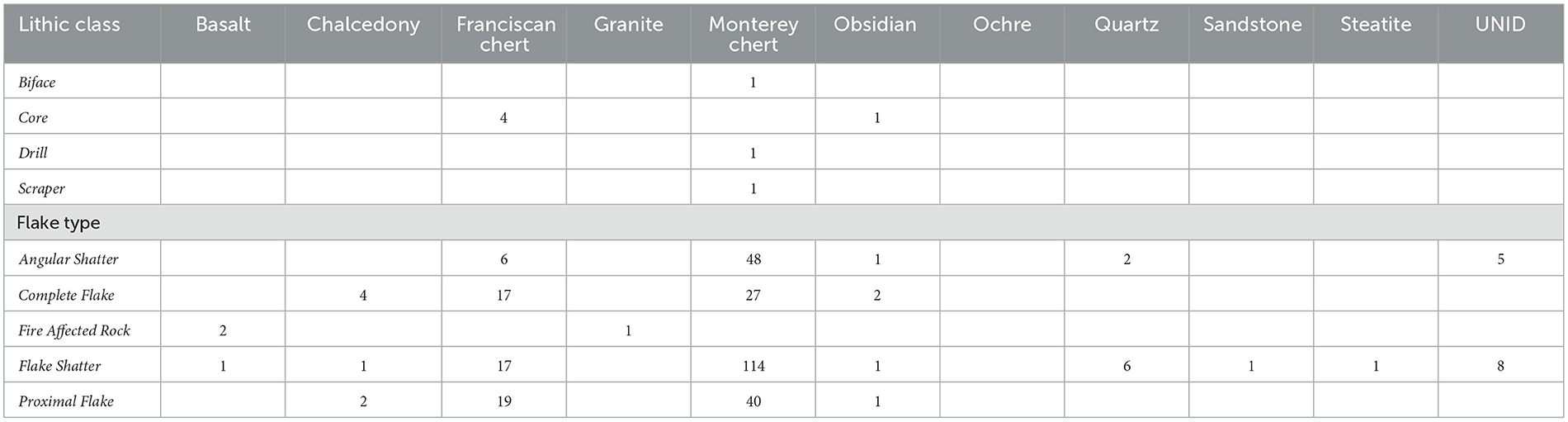
Table 7. CA-MNT-55 flaked stone assemblage from >2 mm screens.
The >4, 3.2, and >2 mm debitage analysis suggests that stone tool primary production and maintenance likely occurred at the site. This is evidenced by the used cores and high densities of flake types, including singular shatter, complete flakes, flake shatter, and proximal flakes, as well as the presence of large (i.e., > 4 and 3.4 mm) and small flakes (i.e., >2 mm). The majority of the debitage is comprised of Monterey chert (70% relative abundance) and the non-local Franciscan chert (18%), which is found north, east, and south of the Hastings reservation. The other non-local stone is obsidian, comprising 2% of the assemblage. Collectively, these three stone types represent 90% of the debitage assemblages (Figure 9).
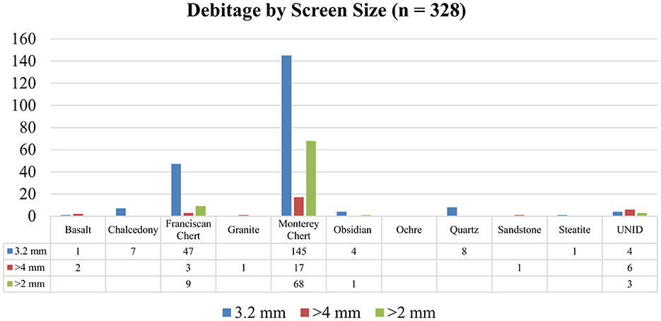
Figure 9. CA-MNT-55 debitage assemblage.
Our collaborative research at the University of California (UC), Berkeley's Hastings Natural History Reservation represents the first co-created and Tribal-centered archaeological research program within the UC Natural Reserve System. Through our surface surveys, geophysical surveys, and small-scale excavations, we have documented a pre-contact Late Period (cal AD 1250 to 1769) and Mission Period (post-1769) site within the Hastings Reservation. These findings represent one of the few case studies of Esselen archaeology outside of cultural resource management archaeology (Boone, 2012; Breschini and Haversat, 2012, 1992; Jones, 2003; Langenwalter and Bowser, 1992), especially within the Upper Carmel Valley and the broader Monterey Peninsula (Breschini and Haversat, 2011). The majority of Esselen archaeology has been conducted along the coast, and as the Tribal Council of the Esselen Tribe of Monterey County notes, large portions of their homelands remain unsurveyed, see above. The primary examples of inland archaeology within Esselen archaeology occur at the Rancho San Carlos complex, which dates from AD 800 to historic times (Boone, 2012; Breschini and Haversat, 2011, 1992) and CA-MNT-33 in the Carmel Valley, which dates to the Middle Period (200 BC–AD 700). CA-MNT-33 was also excavated by Don Howard (Breschini and Haversat, 2011). Due to this, the majority of the archaeological assemblage remains underreported and unanalyzed. Therefore, our project is one of the limited examples of archaeological research within the Upper Carmel Valley.
Our research represents an example of “process-oriented” archaeology approaches that highlight how the archaeological project was conducted collaboratively while also reporting and interpreting the significance of our findings or what (Jordan, 2016) terms “dirt archaeology” (Wright, 2022). As outlined by Wright (2022), such collaborative archaeological studies represent ~1% of published academic research, representing an exception rather than the norm in archaeological research. In collaborative and Indigenous archaeologies, the process and nature of the field research are as significant as the results, especially in research conducted with, for, and by non-federally recognized Tribes, who often do not have the same level of protections and oversight of their cultural heritage as federally recognized communities, although California state legislation such as CalNAGPRA or assembly bill (AB) 978, AB-52 Tribal Cultural Resources, AB-389 Native American repatriation, and AB-275 Native America Cultural Preservation are beginning to remedy some of these issues.
As noted by Laverty (2003), descendants of the Esselen are still fighting the process of Indigenous erasure initiated by Spanish and Mexican colonialism and further reified by the American colonial system. This has involved the lack of federal recognition by the Federal government and erasure by California anthropologists, such as Alfred Kroeber, who declared Esselen and Costanoan peoples extinct in 1925 (Kroeber, 1925; Laverty, 2003), which has been repeated by countless scholars. Despite these and countless other historical injustices, the Esselen Tribe of Monterey County has continued to steward their cultural heritage and sacred sites, often in collaboration with archaeologists such as Gary Breschini, Trudy Haversat, and most recently at the Hastings Reservation through our research project. Fortunately, in 2020, the Tribe became the official stewards of a piece of their ancestral homeland through the project called the Esselen Tribal Lands Conservation Project, picked to receive Proposition 68 funding through the State of California (Esselen Tribe of Monterey County, 2024). The project has returned roughly 1,200 acres to the Esselen Tribe of Monterey County. The Tribe is continually working to steward their ancestral lands.
Through collaborative research projects such as ours, we can ensure the Esselen Tribe of Monterey County retains oversight over all aspects of its cultural heritage. For example, every aspect of the research planning process and development was conducted in collaboration with the Tribal Council, see above. In the field, our research team included Sanchez, Apodaca, several archaeological volunteers, and participants from the Esselen Tribe of Monterey County, including Tribal Vice Chair Cari Herthel and Tribal Administrator and Secretary Jana Nason. Research findings from surface surveys and geophysical surveys were relayed to the Tribal Council during scheduled meetings with Tom Little Bear Nason, Cari Herthel, and Jana Nason, and all aspects of field research were approved in advance by the Tribal Council. Through these protocols, our research team recognized that the ultimate decision-making authority regarding the cultural heritage of the Esselen Tribe of Monterey County is and can only be the Tribe.
Our research project has documented a Late-Period and Mission Period site, CA-MNT-55, which was occupied from cal AD 1650 to the historic era and represents a pre-Mission Period and Mission Period Esselen village site (Figure 6 and Table 3). Indigenous knowledge of these places of refuge has been passed down orally by the Esselen Tribe of Monterey County, and archaeological evidence in Esselen homelands (Breschini et al., 2004; Breschini and Haversat, 2004; Meighan, 1955) and in other Native Californian communities (Brown, 2024; Byrd et al., 2022; Jones et al., 2022; Panich, 2014; Panich et al., 2024, 2018; Schneider, 2015, 2010; Schneider and Panich, 2019). While our research at CA-MNT-55 has not recovered Mission Period glass beads or other items of European manufacture, our recent excavations in the summer of 2023 have confirmed the presence of Mission Period glass beads at the previously unrecorded sites within the Hastings Reservation (Figure 2) further supporting Tribal knowledge related to the occupation of the Upper Carmel Valley before, during, and after the Mission Period. Our findings from the 2023 studies are forthcoming.
The results of our zooarchaeological, paleoethnobotanical, and lithic analyses provide some of the only insights we have about Esselen lifeways during the Late Period from inland site locations in the Santa Lucia Mountains roughly 45 km from the coast following the Carmel River drainage. Our zooarchaeological studies demonstrate an emphasis on terrestrial fauna, including mule deer and leporids such as black-tailed jackrabbits and brush rabbits. Our findings also suggest the cooking of Colubrid snakes, dusky-footed woodrats, California ground squirrels, and other Squiridae based on high burning rates within the faunal assemblage and a lack of carnivore modifications on these remains, suggesting human rather than carnivore deposition in the site. These findings are consistent with other Late Period sites that apply comparable zooarchaeological and taphonomic analyses (Gifford-Gonzalez et al., 2013).
Our assemblage demonstrates the presence of marine organisms such as California mussels, barnacles, and rockfish at the site, demonstrating the importance of marine foods at inland sites. Although our findings highlight the presence of marine foods, their quantities are lower than other inland sites, such as CA-MNT-1701, which is part of the Rancho San Carlos Complex and dates from AD 800 to 1450 (Boone, 2012; Breschini and Haversat, 1992; Langenwalter and Bowser, 1992). Boone's (2012) analysis of the fish assemblage at CA-MNT-1701 included 7,748 NISP fish specimens with sardine and herrings (Clupeidae and Sardinops sagax) making up 85% of the total assemblage at the site. Sardines and herrings rise to 99% when the unidentifiable ray-finned fishes are removed from the relative abundance. While CA-MNT-55 demonstrates the presence of marine organisms, it is quite different from the mass-capturing signatures observed at other inland locales, such as those observed at CA-MNT-1701, which is closer to the coastline than our study area. Therefore, our study provides additional evidence of Esselen foodways within the Santa Lucia Range, suggesting a heavy emphasis on terrestrial mammals and intensive bone grease production based on the quantity of highly fragmented and burned mammalia bones (Table 4 and Figure 8) (Fisher, 1995; Janzen et al., 2014).
The archaeobotanical study indicates that acorns were a component of the foodways at CA-MNT-55, and edible small seeds were also consumed at the site in low densities, based on site preservation. Interpreting acorn use through the quantification and comparison of groundstone artifacts has been a commonly employed strategy in California archaeology (Basgall, 1987; Rosenthal and Hildebrandt, 2019). However, the use of locally available bedrock milling features and ethnographic and ethnohistorical recorded instances of wooden mortars may complicate the relationship between acorn processing and stone tool assemblages. The environmental and cultural setting of CA-MNT-55, such as the abundance of suitable bedrock, oak woodlands, and water, supports the preliminary interpretation of nut food consumption at the site. The main takeaway from the macrofloral research is that soil sample analysis can contribute to our regional understanding of plant use through deep time in the interior ranges of the Carmel Valley. This effort was meant to demonstrate methods that may be employed at other sites in the vicinity so as to encourage intra-site and inter-site comparisons of macrofloral data and build upon our archaeological knowledge of Indigenous plant use.
The lithic analysis demonstrates the diversity of stone tool raw materials used at the site, including local and non-local sources. We recovered one complete granitic pestle, which supports previous reports regarding the presence of numerous bedrock mortars at CA-MNT-55, signaling food production and processing at the site, see above (Breschini and Haversat, 2012). The diversity of lithic raw materials and stone tools at the site further support previous interpretations of CA-MNT-55 as a village site (Breschini and Haversat, 2012). Debitage analysis suggests all aspects of stone tool production occurred at the site, including lithic reduction and tool maintenance (Andrefsky, 2005).
Through our collaborative archaeology model at the Hastings Reservation, our research team seeks to survey and document cultural resources on the 2,500-acre property. Our work to date has re-established the site boundaries for CA-MNT-54, CA-MNT-55, and CA-MNT-56 and located three previously unrecorded sites. However, we have only begun to document the cultural resources on the 2,500-acre reserve. Our field research program provides a model for collaborative archaeological research across the UC Natural Reserve System and its 47,000 acres, which can center and prioritize Indigenous perspectives and cultural heritage.
Our collaborative research program involving members of the Esselen Tribe of Monterey County, the University of California (UC), Berkeley's Hastings Natural History Reservation, the University of California, Berkeley, and the University of Oregon has demonstrated the mutual benefits of a co-created and Indigenous-centered archaeological research program within North America. While initial archaeological studies on the Hastings Reservation occurred over five decades ago, largely conducted by avocational archaeologists, our project represents one of the first Tribal-centered archaeological field programs within the UC Natural Reserve System and, therefore, a model of collaborative research in the post-NAGPRA and CalNAGPRA era.
Our low-impact and collaborative research project conducted with, for, and by the Esselen Tribe of Monterey County has worked to document and protect Indigenous cultural heritage while mitigating archaeological impacts on cultural sites during the research process. With our low-impact and stratified research approach including surface surveys, geophysical surveys, and small-scale excavations, we have documented a pre-contact Late Period (cal AD 1250–1769) and Mission Period (post-1769) site within the Hastings Reservation. Our findings suggest CA-MNT-55 was occupied from cal AD 1650 through the historic era. Therefore, our findings document an Esselen village site prior to and during the period of Spanish colonialism in the region.
These findings represent one of the few case studies of Esselen archaeology outside of cultural resource management, especially within the Upper Carmel Valley and the broader Monterey Peninsula. Therefore, our project is one of the limited examples of archaeological research within the Upper Carmel Valley that documents Indigenous lifeways right before the commencement of the colonial era. Throughout our collaborative research process that seeks to weave archaeology, ethnobotany, historical documents, ethnography, and Indigenous knowledge, we seek to document the critical role of maintaining a connection to cultural landscapes despite three successive waves of European and Euro-American colonialism in the region. In California archaeology, this begins through collaborative and decolonizing research practices that recognize the ultimate decision-making authority of Indigenous peoples. These practices provide an alternative research model that can document cultural persistence, survivance, and resilience, opposing historical narratives of cultural loss and erasure espoused by 20th-century California anthropology regarding the Indigenous societies that occupied the central California coast.
The original contributions presented in the study are included in the article/supplementary material, further inquiries can be directed to the corresponding author.
GS: Conceptualization, Data curation, Formal analysis, Funding acquisition, Investigation, Methodology, Project administration, Resources, Supervision, Validation, Visualization, Writing – original draft, Writing – review & editing. AA: Conceptualization, Data curation, Formal analysis, Funding acquisition, Investigation, Methodology, Project administration, Resources, Supervision, Validation, Visualization, Writing – original draft, Writing – review & editing. AG: Data curation, Formal analysis, Investigation, Methodology, Project administration, Resources, Supervision, Writing – original draft, Writing – review & editing. CG: Data curation, Formal analysis, Investigation, Methodology, Writing – original draft, Writing – review & editing. TN: Conceptualization, Investigation, Project administration, Resources, Supervision, Writing – original draft, Writing – review & editing. CH: Conceptualization, Investigation, Methodology, Project administration, Supervision, Writing – original draft, Writing – review & editing. JN: Conceptualization, Funding acquisition, Investigation, Methodology, Project administration, Resources, Supervision, Writing – original draft, Writing – review & editing. SB: Conceptualization, Data curation, Investigation, Methodology, Resources, Software, Supervision, Validation, Visualization, Writing – original draft, Writing – review & editing. JH: Conceptualization, Data curation, Funding acquisition, Investigation, Project administration, Resources, Supervision, Writing – original draft, Writing – review & editing.
The author(s) declare financial support was received for the research, authorship, and/or publication of this article. The 2021 field research at the University of California (UC), Berkeley's Hastings Natural History Reservation, was generously supported by funding granted to Sanchez through a National Geographic Society Early Career Grant (EC-67884R-20). The Department of Anthropology, University of Oregon, and the University of California (UC), Berkeley's Hastings Natural History Reservation, have provided additional funding support.
We want to thank the Esselen Tribe of Monterey County and the University of California (UC), Berkeley's Hastings Natural History Reservation for the privilege of conducting these studies and making this research a reality. We also want to thank Frank Emerson of the Carmel River Steelhead Association for supporting the project through introductions and early review of the research proposal. We also greatly appreciate the support of Kathryn Field, Mike Grone, Roberta Jewett, and Kent Lightfoot for their assistance in the field. Lastly, we thank our editor Christopher I. Roos, an reviewer, and Leslie Reeder-Myers and Jelmer Eerkens for greatly enhancing the manuscript through their feedback, editing, and evaluations.
The authors declare that the research was conducted in the absence of any commercial or financial relationships that could be construed as a potential conflict of interest.
The reviewer JE declared a shared affiliation with the authors AA, AG, CG, SB, and JH to the handling editor at the time of review.
All claims expressed in this article are solely those of the authors and do not necessarily represent those of their affiliated organizations, or those of the publisher, the editors and the reviewers. Any product that may be evaluated in this article, or claim that may be made by its manufacturer, is not guaranteed or endorsed by the publisher.
Anderson, K. (2005). Tending the Wild: Native American Knowledge and the Management of California's Natural Resources. Berkeley, CA: University of California Press.
Andrefsky, W. (2005). Lithics: Macroscopic Approaches to Analysis, 2nd Edn., Cambridge Manuals in Archaeology. Cambridge, NY: Cambridge University Press. doi: 10.1017/CBO9780511810244
Atalay, S. L. (2006). Indigenous archaeology as decolonizing practice. Am. Indian Q. 30, 280–310. doi: 10.1353/aiq.2006.0015
Atalay, S. L. (2007). Global application of indigenous archaeology: community based participatory research in Turkey. Archaeologies 3, 249–270. doi: 10.1007/s11759-007-9026-8
Basgall, M. E. (1987). Resource intensification among hunter-gatherers: acorn economies in prehistoric California. Res. Econ. Anthropol. 9, 21–52.
Binford, L. R. (1964). A consideration of archaeological research design. Am. Antiq. 29, 425–441. doi: 10.2307/277978
Boone, C. (2012). Integrating Zooarchaeology and Modeling: Trans-Holocene Fishing in Monterey Bay, California (Unpublished Ph.D. dissertation). Santa Cruz, CA: Department of Anthropology, University of California, Santa Cruz.
Breschini, G. S., and Haversat, T. (2004). The Esselen Indians of the Big Sur Country: The Land and the People. Salinas, CA: Coyote Press.
Breschini, G. S., and Haversat, T. (2011). A revised culture sequence for the Monterey Peninsula Area, California. Pac. Coast Archaeol. Soc. Q. 44, 1–24.
Breschini, G. S., and Haversat, T. (2012). Archaeological Materials from CA-MNT-54,−55, and−56, Carmel Valley, Monterey County, California. Salinas: Archaeological Consulting.
Breschini, G. S., and Haversat, T, . (eds.) (1992). Baseline archaeological studies at Rancho San Carlos, Carmel Valley, Monterey County, California, Coyote Press Archives of California Prehistory. Salinas, CA: Coyote Press.
Breschini, G. S., Haversat, T., King, C., and Milliken, R. T. (2004). Ethnographic Overview of the Los Padres National Forest. Arcadia, CA: U.S. Department of Agriculture.
Bronk Ramsey, C. (1995). Radiocarbon calibration and analysis of stratigraphy: the OxCal program. Radiocarbon 37, 425–430. doi: 10.1017/S0033822200030903
Brown, K. M. (2024). Praxis, persistence, and public archaeology: disrupting the mission Myth at La Purísima Concepción. Am. Antiq. 1–18. doi: 10.1017/aaq.2024.20
Brown, T. A., Nelson, E. D., Vogel, J. S., and Southon, J. R. (1988). Improved collagen extraction by modified longin method. Radiocarbon 30, 171–177. doi: 10.1017/S0033822200044118
Burge, D. J. (2023). Securing the Southwest: the Northern Pursuit of Texas, New Mexico, and California. Southwest. Hist. Q. 126, 416–437. doi: 10.1353/swh.2023.0026
Byrd, B. F., Arellano, M. V., Engbring, L., Leventhal, A., and Darcangelo, M. (2022). Community-based archaeology at Síi Túupentak in the San Francisco Bay Area: integrated perspectives on collaborative research at a major protohistoric Native American settlement. J Calif Gt. Basin Anthr. 42, 135–158.
DeNiro, M. J. (1985). Postmortem preservation and alteration of in vivo bone collagen isotope ratios in relation to palaeodietary reconstruction. Nature 317, 806–809. doi: 10.1038/317806a0
Driver, J. C. (2011). Identification, classification and zooarchaeology. Ethnobiol. Lett. 2, 19–39. doi: 10.14237/ebl.2.2011.32
Esselen Tribe of Monterey County (2024). Esselen. Available at: https://www.esselentribe.org (accessed April 30, 2024).
Fages, D. P., and Priestley, H. J. (1919). An historical, political, and natural description of California. Cathol. Hist. Rev. 4, 486–509.
Farnsworth, P. (1987). The Economics of Acculturation in the California Missions: A Historical and Archaeological Study of Mission Nuestra Senora de la Soledad (Ph.D. Dissertation). Los Angeles, CA: University of California, Los Angeles.
Fiedler, P. L., Wong, K. M., and Rumsey, S. G., (eds.). (2013). “Frances Simes Hastings Natural History Reservation,” in The Environmental Legacy of the UC Natural Reserve System (Berkeley, CA: University of California Press), 101–105. doi: 10.1525/9780520953642
Fisher, J. W. (1995). Bone surface modifications in zooarchaeology. J. Archaeol. Method Theory 2, 7–68. doi: 10.1007/BF02228434
Geiger, M. J. (1959). The Life and Times of Fray Junípero Serra, O.F.M. or The Man Who Never Turned Back, 1713-1784. Washington, DC: Academy of American Franciscan History.
Gifford-Gonzalez, D., Boone, C. M., and Reid, R. E. (2013). The Fauna from quiroste: insights into indigenous foodways, culture, and land modification. Calif. Archaeol. 5, 291–317. doi: 10.1179/1947461X13Z.00000000016
Gifford-Gonzalez, D., and Hildebrandt, W. R. (2012). “If mussels weighed a ton: problems with quantifying Santa Barbara Channel Archaeofaunas,” in Exploring Methods of Faunal Analysis: Insights from California Archaeology, Perspectives in California Archaeology, eds. M. A. Glassow, and T. L. Joslin (Los Angeles, CA: Cotsen Institute of Archaeology University of California), 97–108. doi: 10.2307/j.ctvdjrqzg.10
Gobalet, K. W. (2001). A critique of faunal analysis; inconsistency among experts in blind tests. J. Archaeol. Sci. 28, 377–386. doi: 10.1006/jasc.2000.0564
Gonzalez, A., and Field, K. (n.d.). “The analysis of Artifacts from CA-SCR-7, CA-SCR-SCR-10, CA-SCR-14, and CA-SCR-15,” in The Study of Indigenous Landscape and Seascape Stewardship on the Central California Coast: The Findings of a Collaborative Eco-Archaeological Investigation, Contributions of the University of California Archaeological Research Facility Publication Series, Vol. 71, eds. K. G. Lightfoot, M. A. Grone, and G. M. Sanchez.
Gonzalez, S. L. (2016). Indigenous values and methods in archaeological practice: low-impact archaeology through the kashaya pomo interpretive trail project. Am. Antiq. 81, 533–549. doi: 10.7183/0002-7316.81.3.533
Grayson, D. K. (1984). Quantitative Zooarchaeology: Topics in the Analysis of Archaeological faunas, Studies in Archaeological Science. Orlando, FL: Academic Press.
Hackel, S. W. (1997). Land, labor, and production: the colonial economy of Spanish and Mexican California. Calif. Hist. 76, 111–146. doi: 10.2307/25161664
Hackel, S. W, . (ed.). (2022). The Early California Population Project. Edition 1.1. Riverside, CA; San Marino, CA: University of California; The Huntington Library; Art Museum; Botanical Gardens.
Hoggarth, J. A., Culleton, B. J., Awe, J. J., and Kennett, D. J. (2014). Questioning postclassic continuity at baking Pot, Belize, Using Direct AMS 14C dating of human burials. Radiocarbon 56, 1057–1075. doi: 10.2458/56.18100
Janzen, A., Reid, R. E., Vasquez, A., and Gifford-Gonzalez, D. (2014). Smaller fragment size facilitates energy-efficient bone grease production. J. Archaeol. Sci. 49, 518–523. doi: 10.1016/j.jas.2014.06.004
Jones, T. L. (2003). Prehistoric Human Ecology of the Big Sur Coast, California, Contributions of the University of California Archaeological Facility Archaeological Research Facility. Berkeley, CA: Regents of the University of California.
Jones, T. L., Hildebrandt, W. R., Wohlgemuth, E., and Codding, B. F. (2022). Postcontact cultural perseverance on the Central California Coast: sedentism and maritime intensification. Am. Antiq. 87, 505–522. doi: 10.1017/aaq.2022.1
Jordan, K. A. (2016). Categories in motion: emerging perspectives in the archaeology of Postcolumbian indigenous communities. Hist. Archaeol. 50, 62–80. doi: 10.1007/BF03377334
Kroeber, A. L. (1925). Handbook of the Indians of California, Smithsonian Institution, Bureau of American Ethnology. Washington, DC: Government Printing Office.
Langenwalter, P. E. I., and Bowser, B. (1992). “Vertebrate Animal Remains from Three Inland Late Period Archaeological Sites (CA-MNT-1481, CA-MNT-1485/H, CA-MNT-1486/H), Carmel Valley, Monterey County, California,” in Baseline Archaeological Studies at Rancho San Carlos, Carmel Valley, Monterey County, California, Archives of California Prehistory, eds. G. S. Breschini and T. Haversat (Salinas, CA: Coyote Press).
Laverty, P. (2003). The Ohlone/Costanoan-Esselen Nation of Monterey, California: dispossession, federal neglect, and the bitter irony of the federal acknowledgment process. Wicazo Sa Rev. 18, 41–77. doi: 10.1353/wic.2003.0015
Levy, R. (1978). “Costanoan,” in Handbook of North American Indians, ed. R. F. Heizer (Washington, DC: Smithsonian Institution), 485–495.
Lightfoot, K. G. (2008). “Collaborative research programs: implications for the practice of North American Archaeology,” in Collaborating at the Trowel's Edge: Teaching and Learning in Indigenous Archaeology, ed. S. W. Silliman (Tucson, AZ: The University of Arizona Press), 211–227. doi: 10.2307/j.ctv2vt02mm.15
Lightfoot, K. G., and Gonzalez, S. L. (2018). Metini Village: An Archaeological Study of Sustained Colonialism in Northern California, Contributions of the University of California Archaeological Facility Archaeological Research Facility. Berkeley, CA.
Lyman, L. R. (2008). Quantitative Paleozoology, Cambridge Manuals in Archaeology. New York, NY: Cambridge University Press.
Madley, B. (2016a). An American Genocide: The United States and the California Indian Catastrophe, 1846-1873, The Lamar Series in Western History. New Haven, CT: Yale University Press.
Madley, B. (2016b). Understanding genocide in California under United States Rule, 1846-1873. West. Hist. Q. 47, 449–461. doi: 10.1093/whq/whw176
McClure, S. B., Puchol, O. G., and Culleton, B. J. (2010). AMS dating of human bone from Cova De La Pastora: new evidence of ritual continuity in the prehistory of Eastern Spain. Radiocarbon 52, 25–32. doi: 10.1017/S0033822200045008
Meighan, C. W. (1955). Excavation of Isabella Meadows Cave, Monterey County, California. (Reports of the University of California Archaeological Survey No. 29). Berkeley, CA.
Milliken, R. T. (1990). Ethnography and Ethnohistory of the Big Sur District, California State Park System, During the 1770-1780 Time Period. Sacramento, CA: Department of Parks and Recreation.
Milliken, R. T. (2002). “The Spanish and Mission Period Indians of the Santa Cruz-Monterey Bay Region,” in A Gathering of Voices: The Native Peoples of the Central California Coast, Santa Cruz County History Journal, Issue Number Five, ed. L. Yamane (Santa Cruz, CA: Museum of Art and History).
Milliken, R. T., and Schwitalla, A. W. (2016). California and Great Basin Olivella Shell Bead Guide. Walnut Creek: Left Coast Press. doi: 10.4324/9781315432533
Page, L. M., Espinosa-Pérez, H., Findley, L. T., Gilbert, C. R., Lea, R. N., Mandrak, N. E., et al. (2013). Common and Scientific Names of Fishes from the United States, Canada, and Mexico, American Fisheries Society Special Publication: 34. Bethesda, MD: American Fisheries Society.
Panich, L. M. (2014). Native American consumption of shell and glass beads at Mission Santa Clara de Asís. Am. Antiq. 79, 730–748. doi: 10.7183/0002-7316.79.4.730
Panich, L. M., Arellano, M. V., Wilcox, M., Flores, G., and Connell, S. (2024). Fighting erasure and dispossession in the San Francisco Bay Area: putting archaeology to work for the Muwekma Ohlone Tribe. Front. Environ. Archaeol. 3:1394106. doi: 10.3389/fearc.2024.1394106
Panich, L. M., Schneider, T. D., and Byram, R. S. (2018). Finding mid-19th century native settlements: cartographic and archaeological evidence from Central California. J. Field Archaeol. 43, 152–165. doi: 10.1080/00934690.2017.1416849
Reeves, J. S. (1905). The treaty of Guadalupe-Hidalgo. Am. Hist. Rev. 10, 309–324. doi: 10.2307/1834723
Reimer, P. J., Austin, W. E. N., Bard, E., Bayliss, A., Blackwell, P. G., Bronk Ramsey, C., et al. (2020). The IntCal20 northern hemisphere radiocarbon age calibration curve (0-55 cal kBP). Radiocarbon 62, 1–33. doi: 10.1017/RDC.2020.41
Reimer, P. J., Brown, T. A., and Reimer, R. W. (2004). Discussion: reporting and calibration of post-bomb 14C data. Radiocarbon 46, 1299–1304. doi: 10.1017/S0033822200033154
Rosenthal, J. S., and Hildebrandt, W. R. (2019). Acorns in pre-contact California: a reevaluation of their energetic value, antiquity of use, and linkage to mortar-pestle technology. J. Calif. Gt. Basin Anthropol. 39.
Sanchez, G. M., Grone, M. A., Apodaca, A. J., Byram, R. S., Lopez, V., Jewett, R. A., et al. (2021). Sensing the past: perspectives on collaborative archaeology and ground penetrating radar techniques from Coastal California. Remote Sens. 13:285. doi: 10.3390/rs13020285
Santos, G. M., Southon, J. R., Druffel-Rodriguez, K. C., Griffin, S., and Mazon, M. (2004). Magnesium perchlorate as an alternative water trap in AMS graphite sample preparation: a report on sample preparation at KCCAMS at the University of California, Irvine. Radiocarbon 46, 165–173. doi: 10.1017/S0033822200039485
Schneider, T. D. (2010). Placing Refuge: Shell Mounds and the Archaeology of Colonial Encounters in the San Francisco Bay Area, California (Unpublished Ph.D. Dissertation). Berkeley, CA: University of California, Berkeley.
Schneider, T. D. (2015). Placing refuge and the archaeology of indigenous hinterlands in colonial California. Am. Antiq. 80, 695–713. doi: 10.7183/0002-7316.80.4.695
Schneider, T. D., and Panich, L. M. (2019). Landscapes of refuge and resiliency: native Californian persistence at Tomales Bay, California, 1770s−1870s. Ethnohistory 66, 21–47. doi: 10.1215/00141801-7217293
Shaul, D. L. (2019). Esselen Studies: Language, Culture, and Prehistory, LINCOM Studies in Native American Linguistics. Muenchen: LINCOM GmbH.
Silliman, S. W. (2000). Colonial Worlds, Indigenous Practices: The Archaeology of Labor on a 19th-Century California Rancho. Berkeley, CA: University of California, Berkeley.
Silliman, S. W. (2004). Lost Laborers in Colonial California: Native Americans and the Archaeology of Rancho Petaluma. Tucson, AZ: University of Arizona Press. doi: 10.2307/j.ctv1jf2ch0
Stromberg, M. R. (2021). Frances Simes Hastings Natural History Reservation: The History of a Biological Field Station in Carmel Valley. Monee, IL.
Stuiver, M., and Polach, H. A. (1977). Discussion: reporting of C-14 data. Radiocarbon 19, 355–363. doi: 10.1017/S0033822200003672
Tibesar, A., (ed.). (1955). Writings of Junípero Serra. Washington, DC: Academy of American Franciscan History.
van Klinken, G. J. (1999). Bone collagen quality indicators for palaeodietary and radiocarbon measurements. J. Archaeol. Sci. 26, 687–695. doi: 10.1006/jasc.1998.0385
Wahoff, T. L., and York, A. L. (2000). “Evidence for post-mission period Native American ceremonial activity on San Clemente Island, California,” in Proceedings of the Fifth California Islands Symposium, eds. D. R. Browne, K. L. Mitchell, and H. W. Chaney (Camarillo, CA: Minerals Management Service), 641–645.
Wiggins, K. (2016). A Bead Analysis of Northern Chumash Village Site, Tstyiwi: CA-SLO-51/H. San Luis Obispo, CA: California Polytechnic State University.
Wiggins, K. E. (2022). A Place of Small Canoes: An Archaeological investigation of Cayucos, California (Master's Thesis). Humboldt, CA: California Polytechnic State University.
Keywords: California archaeology, community-based participatory research, Esselen Tribe of Monterey County, Indigenous archaeology, Indigenous survivance, low-impact archaeology
Citation: Sanchez GM, Apodaca A, Gonzalez A, Gonzalez C, Nason TLB, Herthel C, Nason J, Byram S and Hunter J (2024) “Letting the ancestors speak”: collaborative archaeology at the Hastings Natural History Reservation. Front. Environ. Archaeol. 3:1426294. doi: 10.3389/fearc.2024.1426294
Received: 01 May 2024; Accepted: 29 August 2024;
Published: 18 September 2024.
Edited by:
Christopher I. Roos, Southern Methodist University, United StatesReviewed by:
Jelmer Eerkens, University of California, Davis, United StatesCopyright © 2024 Sanchez, Apodaca, Gonzalez, Gonzalez, Nason, Herthel, Nason, Byram and Hunter. This is an open-access article distributed under the terms of the Creative Commons Attribution License (CC BY). The use, distribution or reproduction in other forums is permitted, provided the original author(s) and the copyright owner(s) are credited and that the original publication in this journal is cited, in accordance with accepted academic practice. No use, distribution or reproduction is permitted which does not comply with these terms.
*Correspondence: Gabriel M. Sanchez, Z3NhbmNoZTJAdW9yZWdvbi5lZHU=
Disclaimer: All claims expressed in this article are solely those of the authors and do not necessarily represent those of their affiliated organizations, or those of the publisher, the editors and the reviewers. Any product that may be evaluated in this article or claim that may be made by its manufacturer is not guaranteed or endorsed by the publisher.
Research integrity at Frontiers
Learn more about the work of our research integrity team to safeguard the quality of each article we publish.