
95% of researchers rate our articles as excellent or good
Learn more about the work of our research integrity team to safeguard the quality of each article we publish.
Find out more
ORIGINAL RESEARCH article
Front. Conserv. Sci. , 03 June 2024
Sec. Conservation Social Sciences
Volume 5 - 2024 | https://doi.org/10.3389/fcosc.2024.1380083
 Riley J. R. Finn1*
 Murray Ned - Kwilosintun2,3Leah Ballantyne3Ian Hamilton3Janice Kwo3Rayanna Seymour-Hourie4Deborah Carlson4Kristen E. Walters5
 Jennifer Grenz6
 Tara G. Martin1
Sumas Lake (Xhotsa), located in the Fraser Valley, British Columbia, Canada, was the heart of Semá:th Nation Territory and the epicenter of a complex Indigenous food system. For the Semá:th people, the lake represented life and livelihood. In 1924, the lake was stolen and drained in an instance of land theft that occurred during a nationwide campaign of land dispossession and genocide, decimating an ecology that supported a rich and diverse Indigenous food system and replacing it with a settler food system. A century later, in November 2021 climate change induced flooding caused the lake to return, resulting in the evacuation of thousands of people and causing millions in damages to homes and infrastructure. Since the flood, the response has been a continuation of the status quo to protect settler agricultural lands via increased investment in hard structures that control the flow of water based on assumptions of the predictability of future flow conditions. We offer a missing narrative by bringing together an analysis of Indigenous laws and oral tradition with an assessment of the economic costs of “managed retreat”, defined as the purposeful relocation of people and infrastructure out of harm’s way. We find that the cost of buying out properties in the lakebed and allowing the lake to return is close to half the cost ($1 billion) of maintaining the status quo ($2.4 billion), while facilitating climate adaptation, and restoration of a floodplain ecosystem that supported thriving populations of people, salmon, sturgeon, ducks, and food and medicinal plants– including many species which are now endangered. Returning Sumas Lake by centering ‘Water Back’ as a climate resiliency solution, enacts both food systems and ecological reconciliation, addressing the harms caused by the loss of the lake to the Semá:th People that is still felt to this day. In a time when climate change induced flooding is predicted to increase, this study demonstrates how the inclusion of Indigenous laws and knowledges are critical to the development of solutions toward a more sustainable and just future.
In Canada, genocidal colonial policies have robbed Indigenous Peoples of their lives, lands, laws, language, food systems and systems of governance (Truth and Reconciliation Commission of Canada, 2015). Despite acknowledgement of these atrocities and steps toward reconciliation and justice, both the legacies and continuation of colonial policies have negative impacts on Indigenous Peoples. One hundred and fifty years of colonial governance and management are evident across the stolen lands and waters of so-called Canada, where unsustainable development, resource extraction, and climate change have led to unprecedented environmental degradation (WWF, 2017; Westwood et al., 2019). Rivers being dammed, valleys flooded, lakes polluted, and grasslands and forests stripped of their diversity, all represent the loss and erasure of Indigenous food systems that once supported the food, social, ceremonial and technological needs of Indigenous communities (Mathews and Turner, 2017; Turner, 2020; Armstrong et al., 2023). Species extinction and endangerment are at record highs, while major climate events causing catastrophic fires, droughts, and floods are increasing in frequency (WWF, 2018; Grenz and Clements, 2023). The current state of Canada’s environment is the legacy of colonial land and resource management driven by an illusion of limitless resources (Grenz, 2020), and the settler-colonial experiment meant to conquer, tame, and exploit lands and waters stolen from the Indigenous Peoples who, in contrast, sustainably managed the land and waters for thousands of years. One such example was the settler-colonial government’s decision to drain and convert Sumas Lake (Xhotsa means lake) from an Indigenous food system to an agrarian-style food system for white settlers (Reimer, 2018).
On November 16, 2021, an extreme rainfall event led to catastrophic flooding throughout the lower Fraser Valley in British Columbia (BC), Canada and Washington State (WA), United States (Figures 1, 2). Two-day gauge precipitation totals reached 400 mm north of the Fraser Valley, the fourth highest value since 1955 (Gillett et al., 2022). Resulting high water levels in the Sumas and Nooksack River watersheds lead to the evacuation of over 3,000 people in Abbotsford, BC, and over 500 in Whatcom County, WA. The flood resulted in over 670,000 livestock deaths, contamination of fish-bearing waters, and millions in damages (Figure 1). It is estimated that this precipitation event was made 60% more likely due to climate change (Gillett et al., 2022). Farms, homes, businesses, and transportation corridors flooded (Figure 1). Many of those affected by the flooding, learned for the first time that their homes and farms were located on a former lakebed—Sumas Lake. For the Semá:th People, the return of the lake was expected.
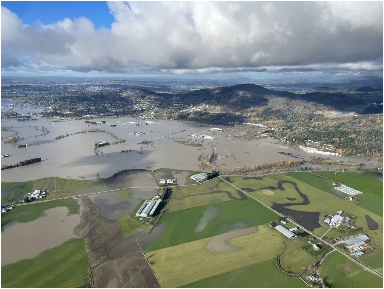
Figure 1 Flooding of Sumas Prairie in November 2021 follows the outline of the former lake (Global News, 2021).
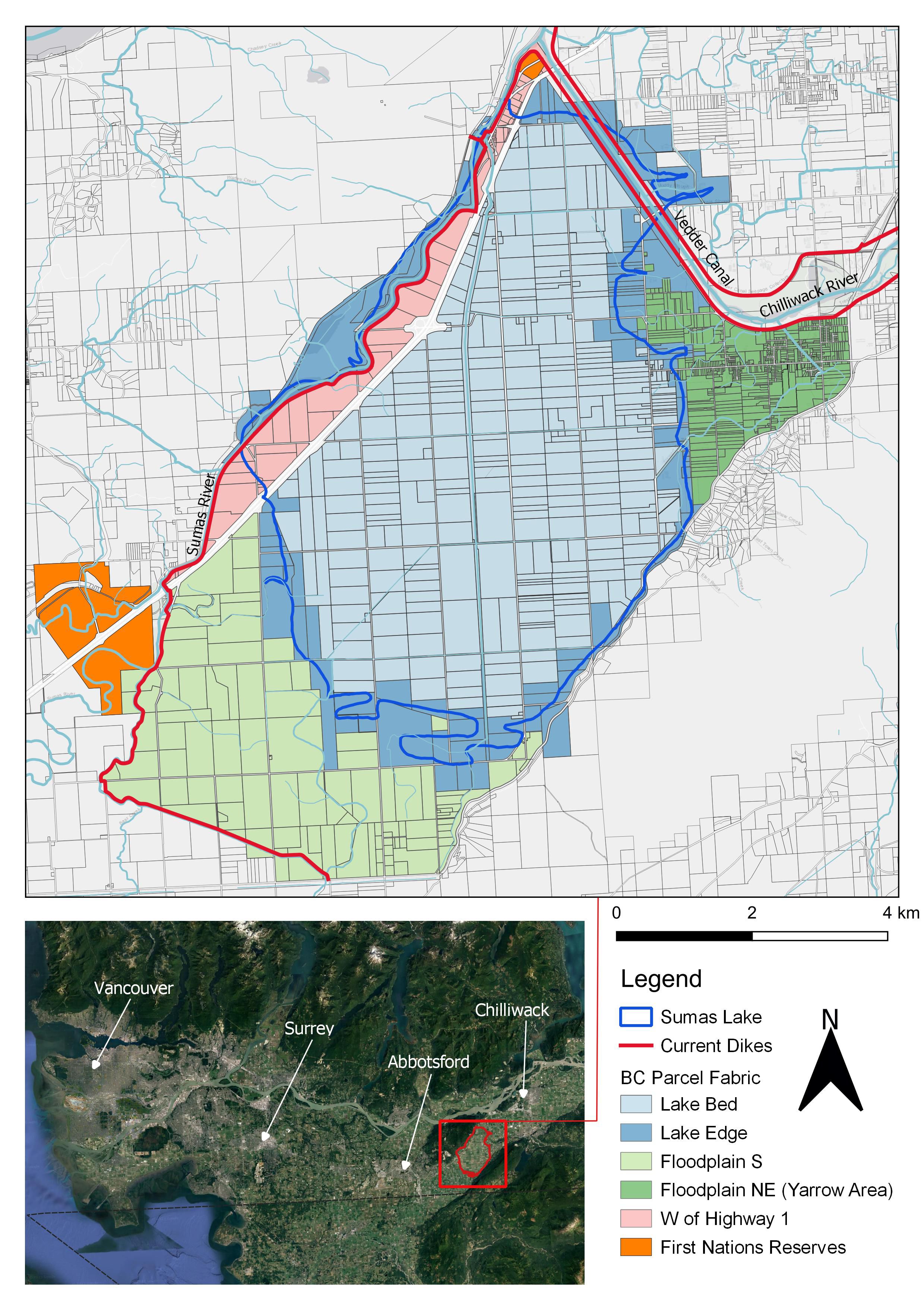
Figure 2 The former Sumas Lake located in the Lower Fraser River, British Columbia. The flooding of Sumas Lake would change which properties are currently protected by dikes. Our analysis is divided into five regions whose properties would become vulnerable to flooding without further alterations to the diking infrastructure.
In the Fraser River Basin, climate change forecasts reveal increases in cold season rainfall will lead to unprecedented winter peak flows and increased runoff variability, ultimately increasing flood risk (Curry et al., 2019; Islam et al., 2019). By 2050 low-lying megacities, deltas, coasts, and islands in many parts of the world, including Canada (Bush and Lemmen, 2019), are projected to experience extreme climate change induced weather events such as flooding under all future emission scenarios (WMO, 2021). Floods are among the most costly and deadly disasters globally (Davenport et al., 2021; WMO, 2021). Between 1970 and 2019, floods accounted for 58,700 human deaths and resulted in economic losses of US$ 115 billion (WMO, 2021). Floods are also the most frequent, accounting for 44% of disasters (riverine floods 24%, general floods 14%) (WMO, 2021). Over this 50-year period, the frequency of floods has increased by a factor of five, and can be attributed to a combination of climate change and land use change (WMO, 2021). Climate change has made flooding more likely as warmer atmospheres hold more moisture, leading to a pronounced increase in the frequency and intensity of heavy rainfall events (Seneviratne et al., 2021).
In the lower Fraser River, these heavy rainfall events are colliding with a history of intensive floodplain development that has relied on engineering of hard structures to control the flow of water. The technological advancements of the 20th century facilitated the channelization of rivers and construction of dikes that characterize a strategy of “flood defense” (Zevenbergen et al., 2013). Often implemented in an ad hoc or post hoc fashion, flood defense is increasingly meeting its limits as incorrect design assumptions, inadequate funding, and poor maintenance are magnified by a changing future climate (Zevenbergen et al., 2013; van Herk et al., 2015). Despite these challenges, the approach to managing floods can be slow to change where historically contingent events precipitate institutional patterns that are linked over time, resulting in the avoidance of viable alternatives in favor of strategies that were employed in the past (Wilson, 2014). This process often referred to as “path dependency” relies on deeply held assumptions that are recognized as common knowledge which then guides the conceptual framing of adaptation measures (Preston et al., 2015; Parsons et al., 2019). A decline in community resilience has been linked to an unwillingness to change in the face of new problems (Scheffer et al., 2003; Wilson, 2014). Climate change represents a wider range of variability to contend with moving into the future and requires a wider range of alternatives be considered (Scheffer et al., 2003).
As communities, politicians, and planners grapple with how to move forward in the wake of the Sumas flooding event, and what it signals for the future, we offer insight as a multidisciplinary group of Indigenous and non-Indigenous scholars, lawyers, and land stewards grounding our analysis in two-eyed seeing. Using the strengths of Indigenous ways of knowing through one eye, and the strengths of Western ways of knowing in the other, two eyed seeing brings these worldviews together to answer the questions of what we should do, what our responsibilities are, and how we should live while on Earth (Marshall et al., 2015). We draw on the legal traditions of the Peoples of the Lower Fraser to outline the governing principles and responsibilities that have guided Indigenous management of the area since time immemorial (LFFA, 2021a), and an examination of the costs of adaptation measures that have been proposed in response to the flooding, to present an alternative solution of reclaiming and revitalizing the lake via managed retreat—the purposeful, coordinated movement of people and assets out of harm’s way (Siders et al., 2019).
Our analysis is not intended to represent a complete account of the cost and benefit of reclaiming and revitalizing the lake, or continuing to invest in protecting the prairie. Rather, it illustrates how the option of reclaiming and revitalizing the lake is within the realm of economic costs associated with maintaining the status quo and presents a missing narrative. In this time of climate and biodiversity crisis (Ray et al., 2021), and commitment to upholding the rights of Indigenous People’s (British Columbia, 2019), ‘Lake Back’ as a climate resiliency solution is worthy of meaningful consideration. As the ‘Land Back’ movement gains momentum around the world, many argue that there cannot be ‘Land Back’ without ‘Water Back’ (Leonard et al., 2023). These movements are not just about seeking justice, but about establishing resilient climate futures informed by the knowledges of climate adaptation experts—Indigenous Peoples. The increased frequency of major climate events and their dire consequences demands the courage to create solutions informed by multiple worldviews, honouring the true history of lands and waters (Grenz and Armstrong 2023), and applying a food systems lens. In this case, we demonstrate how consideration of allowing Sumas Lake to return, drawing upon Indigenous laws, knowledges, and decision-making, such as understanding the responsibility of Xólhmet te mekw stám ít kwelát/xáʔɬəmət ct mək̓ʷ ʔə kʷə swéʔs (‘we have to take care of everything that belongs to us’)1 could reclaim climate resiliency in the Fraser Valley, while enacting ecological and food systems reconciliation.
Located between Sumas Mountain and Vedder Mountain in the Lower Fraser Valley (Figures 3, 4), British Columbia, Canada, Sumas Lake was home to an extraordinary abundance of animal and plant life that supported a rich Indigenous food system (Reimer, 2018). The lake was the center of a dynamic floodplain landscape; over the course of a year it could vary from an area of 9,000 acres (3,642 ha) and a depth of 3 meters in the winter, to an area of 26,000 acres (10,522 ha) and depth of 11 meters in the spring (Murton, 2008; Reimer, 2018). Of the 102 species at risk of extinction in the Lower Fraser (Kehoe et al., 2020), 72 are likely to have inhabited the Sumas region including 11 species of anadromous fishes and 30 species of birds (Supplementary Table S1). Over the past 150 years, the Lower Fraser has undergone colossal changes with its vast network of rivers, creeks, wetlands, and floodplains reduced to a series of ditches, canals, dikes, floodgates, agricultural fields, and residential and urban development (Boyle, 1997). Less than 30% of native vegetation remains intact and over 85% of floodplain habitat and 64% of streams have been lost (Finn et al., 2021).
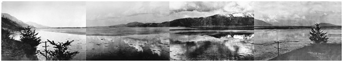
Figure 3 Panorama of Sumas Lake taken by Leonard Frank, pre-1922, accessible from Vancouver Public Library’s photograph repository; photographs taken before 1924 are in the public domain.
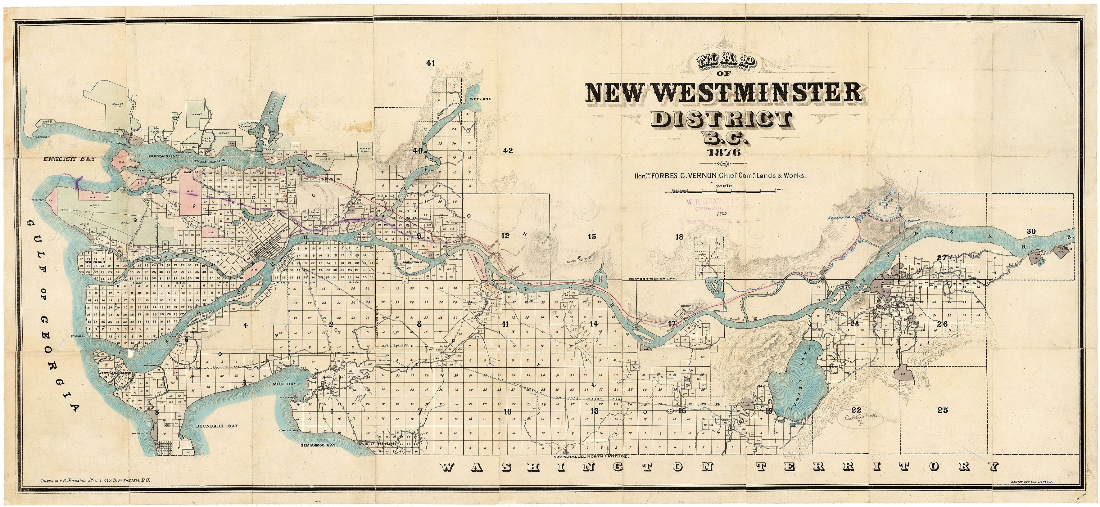
Figure 4 Map of the lower Fraser Valley from 1876. Sumas Lake is the large body of water on the eastern end of the valley (British Columbia Department of Lands and Works, 1876).
Sumas wetlands connected migratory shorebirds and their breeding grounds across continents. Fields of blue grass in the silty soils surrounding the lake attracted birds of prey along with flocks of ducks, tundra swans, great blue herons, greater white-fronted and cackling geese (Reimer, 2018). The waters themselves were home to multiple species of Pacific salmon (Oncorhynchus spp.), and its sandy banks supported rich sturgeon (Acipenser transmontanus) spawning grounds. Wild hazelnuts (Corylus cornuta), roses (Rosa spp.) and strawberries (Fragaria spp.) lined its shores (Reimer, 2018). For the Peoples of the Lower Fraser, the Fraser River is known as the Stó:lō and considered the ‘river of all rivers’ connecting the waters and peoples to each other (LFFA, 2021a). Stó:lō fishermen caught sturgeon using a weir on the Sumas River and gathered wapato (wild potato) (Acipenser transmontanus) in the wetlands skirting the lake’s edge. For the Semá:th people the lake was life, it was their livelihood, their food system and their culture. It was everything.
“My grandpa used to say, that in the Coast Salish Territory, Semá:th was the central location where the people used to gather. The people gathered in the summertime as we had Semá:th Lake that once offered every species of fish right there at the front of our village and in the wintertime, people gathered there from all parts of the Coast Salish Nation for the winter ceremonies, and I hope sometime in the future that we can re-establish Semá:th as a central place amongst the Coast Salish.” ~ Chief Dalton Silver (LFFA, 2021a)
“At Sumas we caught them [ducks] by the thousands … [There were so many] at Sumas it used to turn black … when they drained it out, after months of drying out they went and ploughed it, Sturgeons were getting ploughed up, 10, 12 even 14-foot sturgeon that were still alive when they were ploughing the land.” ~ Luschiim (Luschiim Arvid Charlie) (Commemorating Yeyumnuts, 2018)
The draining of Sumas Lake was one act in a Canada-wide process of land dispossession and genocide carried out by colonial governments on Indigenous Peoples across Canada. Land governed and stewarded by Indigenous People for millennia was stolen and given to settlers or retained by the crown and used for resource extraction (Truth and Reconciliation Commission of Canada, 2015).
The formal process of land dispossession for the Semá:th and other Peoples of the lower Fraser began in earnest in 1858 with the discovery of gold in the Fraser Valley (Tennant, 1990; Reimer, 2018). Due to the cost of surveys to the colonial government, a pre-emption system was established to encourage occupation of British Columbia by Canadian and British subjects, it afforded settlers the right to 160 acres (65 ha) on the condition that they occupy and establish European-style agriculture, plots would then be surveyed and purchased for a maximum of ten shillings per acre at a later date (Mikkelsen, 1950). As over 30,000 miners flocked to the region, disputes over lands between settlers and Indigenous communities escalated (Tennant, 1990). In 1864, James Douglas, the governor of BC, devised a set of reserves between 400 and 9,600 acres (162 – 3,885 ha) in an attempt to reduce conflict and placate Indigenous communities (Tennant, 1990). Three years later, these comparatively small parcels were reduced by 92% by the Chief Commissioner of Lands and Works, Joseph Trutch, leaving only three small reserves in the vicinity of Sumas Lake: The Upper Sumas, Aylechootlook, and Sumas Cemetery Reserves (Murton, 2008). Throughout this period of land theft, Indigenous leaders advocated for their rights and made clear that the reserves were too small for the needs of their people. Speaking at a Royal Commission on Indian Affairs in 1915, Selesmlton (Chief Ned) spoke of Semá:th territory:
“This is [our] land, and that is what the old people know and used to say … The old people used to say that the White people will be shoving you around all over this open prairie to get our food … When I first came up to be a grown boy myself, they fixed up this place and surveyed it for us people. They owned it, and that is what is worrying me all this time, because I am always poor. I don’t get satisfactory food for my children to eat.” (Reimer, 2018)
By the 1920s plans were afoot to drain Sumas Lake to create more farmland for settlers (Figure 5). By 1924 the Chilliwack River had been diverted west into the newly formed Vedder Canal and soon after the lake was drained through the Sumas Drainage Canal and into the Fraser River around the northeastern tip of the Sumas Mountain (Reimer, 2018). The project took many years and entailed massive cost overruns, quickly becoming a financial disaster and an ongoing source of controversy (Murton, 2008). The Sumas First Nation was never compensated for the loss of the lake and in 2013 they filed a land claim for the former lake (Smith and Verstraten, 2013).
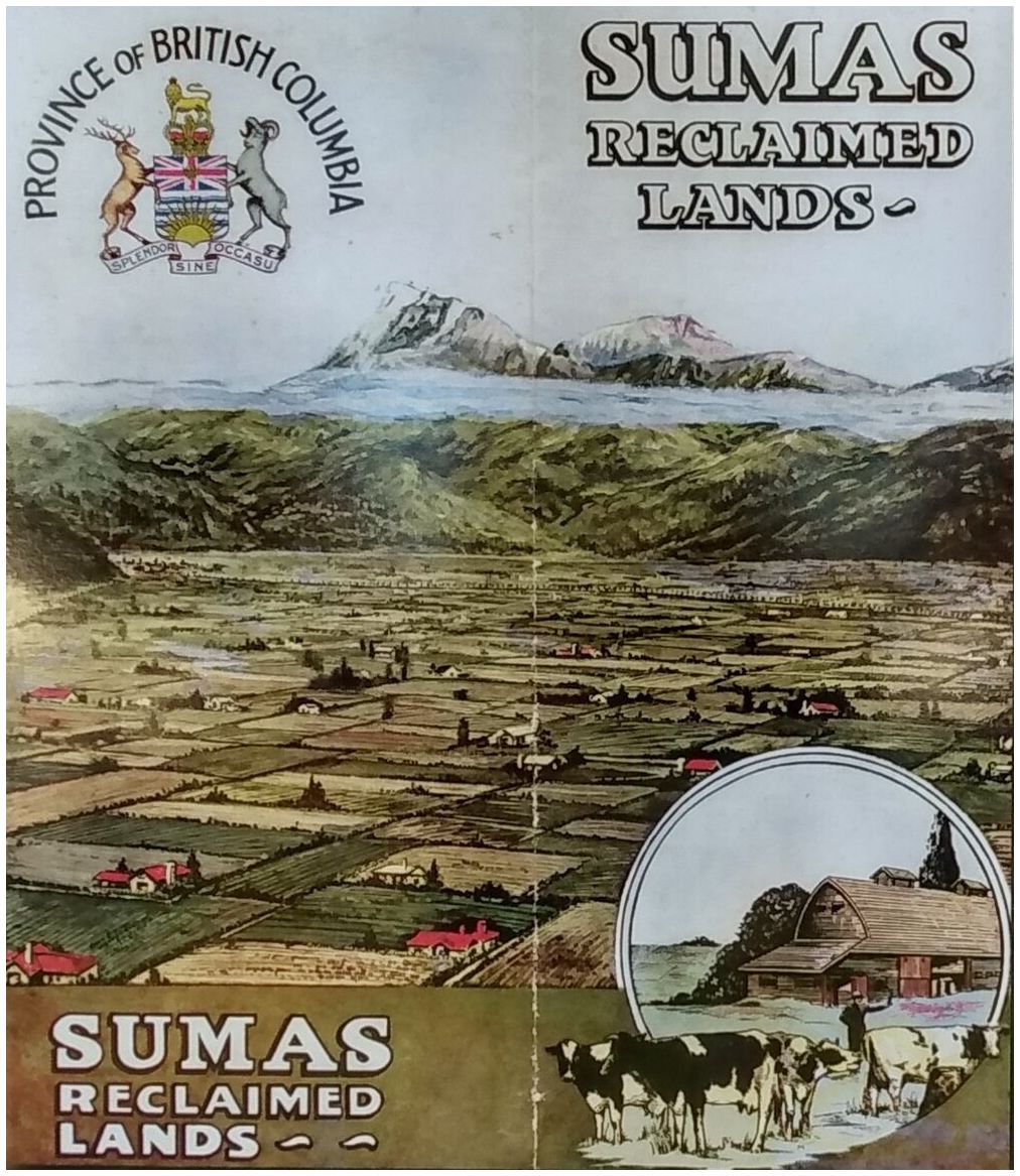
Figure 5 Pamphlet developed to promote the sale of ‘reclaimed’ lands following the draining of Sumas Lake. Interpretative kiosk - Yarrow Pioneer Park.
We drew on the laws and oral traditions of the Peoples of the Lower Fraser as they pertain to fisheries governance and watershed management through a review of the outputs of a collaboration between West Coast Environmental Law and the Lower Fraser Fisheries Alliance to Revitalize Indigenous Law for Land and Water (RELAW) (LFFA, 2021a). The RELAW project pairs trained lawyers with Indigenous Nations to develop written laws and policies grounded in the stories and wisdom of Nation Elders and community dialogue. These laws tell us about how the ancestors stewarded the region rich in wildlife and resources, along with the consequences of not following these practices. Resources were not always present on these territories, and they exist today because of the effort, agency, and ingenuity of ancestors. We examined the products of the RELAW project and used them to illustrate the perspective of the Peoples of the Lower Fraser as it related to the case of Sumas Lake. These laws include practices for adapting to changing environments, how to respond in times of crises, and the purposeful stewardship of the land to achieve abundance. There is an inherent responsibility based on the reciprocal relationship between the Peoples of the Lower Fraser and the resources that were established by their eternal ancestors. The land and water of the region serve as reminders of how we should conduct ourselves, when to act, and shows us that history can repeat itself throughout time. As the late Kwa:l, Lester Ned Sr., shared:
“History tells us stories about our territory and us being a part of it.” (LFFA, 2021a, pg. 30)
Four alternative ‘recovery strategies’ to the 2021 floods have been proposed (Table 1). These strategies were developed by a contracted external engineering firm by the City of Abbotsford to develop flood mitigation options for the Sumas Prairie. The proposed options were guided by principals that included the maintenance of agricultural capacity that was created by the draining of the lake and the maintenance or improvement of existing flood protection (City of Abbotsford, 2022). We compared the costs of each of these four scenarios, with the cost of returning the lake through the acquisition of impacted properties through a process of managed retreat (Siders et al., 2019).
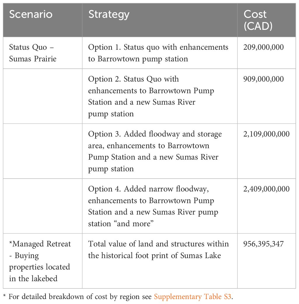
Table 1 Comparison of cost estimates of four future pathways proposed by the City of Abbotsford to a scenario of managed retreat, for the Sumas Lake Region.
We assessed the potential cost of reclaiming and revitalizing Sumas Lake through managed retreat utilizing a spatial analysis of the assessed values of the properties currently within the historic lakebed boundary. Data describing the assessed structure and land values were obtained from BC Assessments (BC Assessment, 2024). BC Assessment maintains real property assessments for the province of British Columbia in compliance with the Assessment Act which requires that properties be assessed as of July 1st each year. The BC Assessment layer was joined to the provincial parcel fabric (property boundary or cadastral map) producing a spatial map of property values for the 2020 assessment year. The 2020 assessment year was selected for comparative purpose as it corresponded with the timing immediately prior to the flood event. We also examined values for the 2021 assessment year which revealed that land values had fallen slightly since the flooding event. We then developed a spatial layer of the historical lake boundary based on surveyor notebooks from the mid-19th century (North and Teversham, 1984). The lake boundary layer was then overlaid with the provincial parcel fabric to identify properties that would be lost if the lake were to return. Current flood infrastructure in the Sumas lakebed includes several dikes, that influence which properties would be impacted if the lake were to return. We included this by creating subregions of parcels that are fully, or partially covered by the historical lakebed, as well as those properties that would be inside the dikes that currently prevent the lake from returning, and breakdown their property values separately (Figure 2; Supplementary Table S3).
Although established processes may have been disrupted by colonization, the peoples of the Lower Fraser continue to practice and revitalize their laws. The legal processes shown in the sxwōxwiyám/s ̌xʷə ̌ xʷəyém (‘stories of the distant past’ or ‘tell stories’) are being used today for exercising jurisdiction and decision-making authority. We identified how legal processes practiced by the Peoples of the Lower Fraser can inform the current response to climate disasters along two broad themes.
Indigenous jurisdiction is based on ties to ancestry and language that trace back to eternal ancestors (LFFA, 2021b, p.24). There are stories that describe how ecological conditions were established by ancestors and other beings, such as Xe’xá:ls/x̌eʔx̌é∙l̕s (“Transformers”), and how these conditions were maintained in abundance by Indigenous stewardship throughout time (LFFA, 2021a, p. 36). The stories also provide a reference for assessing the adherence to Indigenous laws; sxwōxwiyám/s ̌ xʷə ̌ xʷəyém illustrate the historic baseline conditions against which cumulative impacts and risk to ecological, cultural and economic well-being are to be assessed, providing a standard for restoring the land, water, and communities today. When these stewardship responsibilities are not followed, resulting in conditions not being maintained, impacts to the land, water, animals, and people are felt (LFFA, 2021a, p.46). As ecological conditions decline, food sources from the water, land, and air no longer exist in abundance, spiritual and physical health declines, and governance, ceremonial processes, and relationships with ancestors are disrupted.
Today, when jurisdiction is not respected and Indigenous Knowledge is excluded from land use decisions, negative consequences flow to various relationships and aspects of life (LFFA, 2021a, p.48). The draining of Sumas Lake and resulting floods is one example of the negative consequences to all aspects of life, others include ongoing crises associated with inadequate salmon returns and the associated loss of cultural practices in connection to the lake (LFFA, 2021b, p.16). Moving forward will require engaging Indigenous Knowledge transfer and learning by doing in the assessment of cumulative effects to ecological, cultural, and economic well-being of the region (LFFA, 2021a, p.52).
There are laws of the Peoples of the Lower Fraser that rest on stories of how the water brings the people together (LFFA, 2021a, p.44). For example, the Sumas River formed a border between the Semá:th and their neighbors the Ts’elxweyeqw. Cooperating on the management of a fishing weir that spanned the river was required to ensure the mutual interest of abundant salmon, and the maintenance of healthy lands and waters (LFFA, 2021a, p.44).
The response to crises over millennia by the Peoples of the Lower Fraser has been guided by instruction from people with necessary expertise. Great floods have happened in the Lower Fraser historically as shown in the sxwōxwiyám/sx̌ʷəx̌ʷəyém, the way in which the floods were overcome were through hard lessons and collaboratively working together: S’iwes Toti:lt Q’ep/syə́θəstəl̕ ʔəy səlí̕ q̓ tátələ̕ t ‘teaching and learning together’ (LFFA, 2021a, p. 18). Members of the impacted community, and those who have a role to play in finding a solution to the crisis would come together to develop a plan of action (deliberation). This principle is shown in the many versions of the Women Changing the Men sxwōxwiyám/s ̌ xʷə ̌ xʷəyém where the women planned a response to the men’s failure (LFFA, 2021a, p.17).
The City of Abbotsford has proposed four flood recovery options that range from $200 million to $2.4 billion each, with the cheaper options focusing on upgrading the pump system, which keeps the lake from returning, and the most expensive including a narrow floodway for excess water (City of Abbotsford, 2022) (Table 1). None of the proposed options by the City of Abbotsford include managed retreat. Option 4 does include the purchase of private properties that are largely outside of the former lakebed in order to create a narrow floodway. The process employed by the City of Abbotsford involved hiring an engineering consulting firm to estimate the costs of maintaining the lakebed as a prairie (City of Abbotsford, 2022). The cost estimates provided did not include the costs of current or future damages from flooding events.
Based on the 2020 Assessed Land values for BC, our estimate of managed retreat through the acquisition of properties across five regions likely to be impacted by the return of the lake (Figure 2) total approximately $956 million (Table 1). In addition to acquisition costs there are other economic factors to consider. Depending on the scale of managed retreat, the construction of new dike infrastructure may be required. Other costs including planning, communication, cleanup of infrastructure and decontamination are also important considerations. A systematic review of floodplain buyouts carried out in the US found that transaction costs typically make up about 80% of the total project costs, although consistent budgetary data is lacking (Curran-Groome et al., 2021). Nevertheless, even if the cost of managed retreat doubled, it is still less than estimates for Options 3 and 4 that are currently being promoted by the City of Abbotsford (City of Abbotsford, 2023) (Table 1).
As decision makers and Indigenous and non-Indigenous communities reconcile how to move forward in the face of extraordinary recovery costs and uncertainty following the catastrophic flooding of Sumas Prairie, we offer a missing narrative through the comparison of recovery options proposed by local government with a scenario of managed retreat that would allow Sumas Lake to return. Our analysis is grounded in two-eyed seeing, bringing together Indigenous Knowledge with western science, to contrast two alternative futures for the Sumas region. Our analysis reveals that both pathways will incur significant costs, yet it may be twice as expensive to support the status quo by retaining the lakebed as farmland, than to pivot and undertake a process of lake reclamation and revitalization via managed retreat.
In Canada and elsewhere, the building of dikes and levees to protect communities from flooding and sea level rise has been the dominant practice (Zevenbergen et al., 2013; Oulahen, 2015; Winsemius et al., 2016; Morrison et al., 2018). Today these engineered solutions may not deliver long-term security and safety in the face of sea level rise and increased extreme rainfall events. They also represent the perpetuation of an institutional pattern set in motion by colonization, that has violated the Laws of the Peoples of the Lower Fraser. In recognition of these issues, in other parts of BC, dikes are being removed and marshes restored in an effort to recover imperiled salmon populations and improve ecosystem resilience under climate change (Baker, 2023).
Despite the existence of an economically viable alternative that carries additional potential benefits for endangered species, and climate adaptation, the option of returning the lake has not been suggested as an alternative by local government. This can be an indication that current processes for responding to crises are caught in a pattern of path dependence, which can lead to the deterioration of community resilience over time (Wilson, 2014). Many of the homes and businesses located within the Sumas lakebed are considered repetitive loss properties (RLPs) — properties that have flooded and received insurance claim payments multiple times. Property owners face an uncertain future, many of which were uninsured prior to the recent flood, and others unable to get insurance moving forward (Zussman, 2021). In 2015, an assessment of the dikes protecting the lakebed revealed them to be inadequate (Northwest Hydraulic Consultants, 2015), yet due to the high cost of upgrades no action was taken. The assessment of the Sumas Lake Reclamation dike (16.7 km) revealed its condition to be ‘unacceptable’. In fact, none of the 74 dikes reviewed in the lower Fraser ‘met’ the current provincial standards and none ‘fully met’ or ‘exceeded’ the standards (Northwest Hydraulic Consultants, 2015). In contrast to the results of the 2015 dike assessment report commissioned by the Province, the City of Abbotsford Drainage Master Plan identified both the Vedder Canal and Sumas dikes to be in “excellent shape” (City of Abbotsford, 2018). Although the plan discusses upgrades, lack of funding to implement proactive flood planning has been identified as a persistent issue in the region (Olsen, 2019). The costs of upgrades for the Sumas Lake Reclamation dike, which failed in two places (Figure 6), are estimated to be over $2 billion and could still potentially be seismically unstable even if the height of the dike was raised (Northwest Hydraulic Consultants, 2015).
Transboundary considerations complicate the situation further. Mitigating flows from the Nooksack River in Washington State creates a variety of physical and political challenges. The current dikes protecting the Sumas Lake bottom create multiple sumps where flood waters from the Nooksack lead to flooding issues on the opposite side of the diking system in the prairie south of the lake (Figure 6). These areas are openly acknowledged as a ‘floodway’ in the US and are labeled as ‘unprotected floodplain’ in the City of Abbotsford flood protection scenarios (City of Abbotsford, 2023). Constructing dikes around the town of Everson in Washington State ($29 million) (KWL, 2020) has been identified as a potentially cost-effective option, however, the reality of further conveying flood waters downstream towards the town of Lynden, Washington is considered politically untenable (Olsen, 2022).
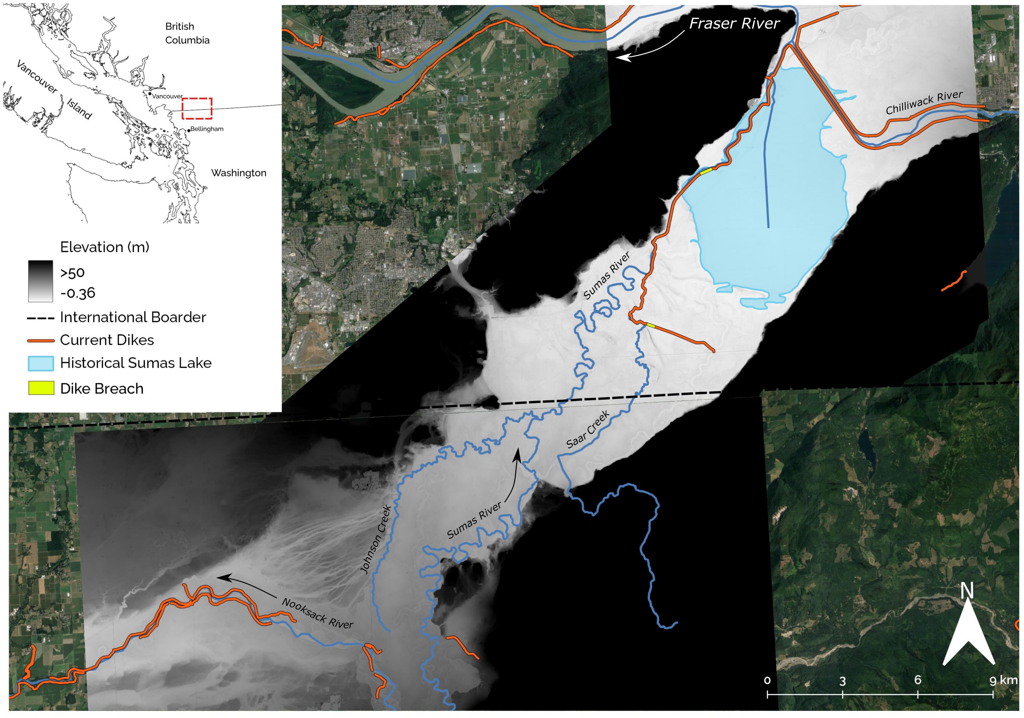
Figure 6 LiDAR derived digital elevation model for the Sumas Lake and Nooksack River floodplain. Arrows indicate the usual direction of flow for the Sumas and Nooksack River. When the Nooksack River floods, it temporarily joins the flow of the Sumas River and Johnson Creek, sending flood waters toward historic Sumas Lake.
We argue that it is time for Indigenous voices to contribute to shaping a new paradigm of flood management in the lower Fraser. This new paradigm acknowledges the crimes of stolen lands and waters from the Semá:th People and other Peoples of the Lower Fraser. The principles for a new paradigm are directly reflected in the laws of the Peoples of the Lower Fraser. There are stories of how the water brought different Nations together in order to share responsibility in managing the resources it provides. There are stories of how the proper response to crises involves bringing all those affected along with those who have necessary expertise to engage in a process of S’iwes Toti:lt Q’ep/syə́θəstəl̕ ʔəy səlí̕ q̓ tátələ̕ t (‘teaching and learning together’).
Water Back, or in this case ‘Lake Back’, through managed retreat can be part of an integrated and inclusive approach to managing flood risks when undertaken in the context of flood risk assessment, long term planning and community dialogue. For example, in Grand Forks, BC, following major flood events in 2017 and 2018, the local government is using funding from Infrastructure Canada’s Disaster Mitigation and Adaptation Fund to help buy out and relocate or demolish more than 70 houses and buildings in the floodplain, restore natural floodplain habitat, and realign and upgrade dikes. The decision was taken after public consultation, and understanding that long term costs of flooding could otherwise be three times the cost of the mitigation measures (Federation of Canadian Municipalities, 2021).
Buying back land is nothing new in Canada. BC Hydro spent more than $20 million to buy up Peace Valley properties for the Site C hydro dam in the years prior to official project approval (Cox, 2018) and 3,193 tracts of land have been identified for acquisition to make way for the Trans Mountain pipeline (Bellrichard, 2019). The City of Abbotsford has also recommended the purchase of private property in their flood recovery scenarios, however those properties are not in the historical lakebed (City of Abbotsford, 2023).
In a time when transformational change is needed to safeguard communities in a changing climate, stem the loss of biodiversity and support reconciliation through the implementation of United Nations Declaration on the Right of Indigenous Peoples (UNDRIP), the absence of a discussion around restoring and revitalizing the lake is an oversight. Managed retreat offers a more adaptive regime for floodplain management than the narrowly defined flood defense strategies under consideration. It also presents legal, logistical, ethical, political, financial, and architectural challenges that need to be addressed by decision makers, as well as rights and title holders (Carey, 2020; Bark et al., 2021). The Laws of the Peoples of Lower Fraser clearly state how ecological and social abundance was maintained through stewardship and respect, and that a lack of respect for jurisdiction will cause negative consequences. Collective action among all those affected by disasters was required for overcoming the challenges of the past, and engaging with Indigenous Knowledge Holders in a process of learning by doing will be required moving forward.
We did not comprehensively analyze the value of a future with or without the return of Sumas Lake. The history of the region as a dynamic floodplain system means the current landscape of the Lower Fraser Valley includes some of the most fertile agricultural land in Canada. As a result, the prairie is particularly suitable for vegetable production like carrots and potatoes. The Sumas Prairie provides nearly all the vegetable production in the City of Abbotsford, including over half the potatoes grown throughout the entire Lower Fraser Valley, as well as substantial dairy, chicken and egg production (Kennedy, 2021). However, before the lake was drained, it supported a rich Indigenous food system. The Peoples of the Lower Fraser and settlers grazed their cattle on the grasses in the lands surrounding the lake, hunted deer, elk and birds, fished and cultivated food plants (Murton, 2008; Reimer, 2018). Returning the lake would restore critical habitat for imperiled and economically important Pacific wild salmon, sturgeon, and migratory migratory birds along with food plants and medicines valued by the Semá:th People. Research elsewhere has shown that the restoration of Indigenous water and land governance can lead to significant co-benefits including reduced need for Indigenous communities to access the healthcare system, increased labor productivity, improved social cohesion, nation building and resurgence, and improved stewardship of biodiversity (Rose et al., 2016; Traditional Owner Partnership and Alluvium, 2022).
There have been a range of studies which have illustrated challenges associated with the over-reliance on cost-benefit analysis for determining where managed retreat should take place (Tubridy et al., 2022). The relative lack of maintenance costs associated with managed retreat means that time scale, discount rates, and our ability to predict future conditions all have a large impact on our understanding of the costs and benefits involved (Hino et al., 2017). Further, the inclusion of values that are not reducible to monetary value, such as the cultural values associated with recovering an Indigenous food system for the Semá:th People along with value of restoring habitat for many species at risk (Supplementary Table S1), requires assessment through more deliberative methods (Martinez-Alier et al., 1998; Tubridy et al., 2022).
The examination of land values alone, demonstrates the economic feasibility of returning Sumas Lake relative to the other alternatives under examination (Table 1) and illustrates how path dependency is operating in the region to frame solutions within a confined conceptual paradigm of flood defense, a strategy that will be increasingly difficult to uphold under a rapidly changing climate and hydrological regime (Curry et al., 2019; Islam et al., 2019). Managed retreat offers a solution to climate change induced flooding, allowing floodwaters a place to go and potentially mitigating their downriver impact. The co-benefits associated with large scale restoration of habitat for Fraser River salmon, sturgeon and other wildlife, the creation of recreation opportunities, storage of future flood waters, carbon capture, cultural revitalization, education, and many other potential sources of value should be considered. Our analysis is intended to start this discussion. It is intended to open space to consider the costs of the actions themselves and contribute to a conversation about whether continued investments in the status quo works towards stated goals of reconciliation, climate change adaptation, Indigenous food sovereignty, and the protection and recovery of endangered species. A question that needs to be asked is — whose food system are we prioritizing the recovery of? The future under continued climate change is increasingly uncertain and now is the time to explore alternative approaches that are guided by lessons learned over time immemorial and passed down through the eternal ancestors of the Peoples of the Lower Fraser. The Spirit of the Lake is alive and well.
British Columbia has committed to the implementation of UNDRIP through Declaration on the Rights of Indigenous Peoples Act (DRIPA) (British Columbia, 2019), which entails respecting Indigenous governments and establishing collaborative management relationships with nations in their territory. The Semá:th people must have a voice in the decisions concerning the future of Sumas and the Xhotsa. We hope our analysis provides a moment of pause and reflection on the actions of the past that displaced an entire Nation, along with the plants, animals and ecosystems which supported them. Legal principles of the Peoples of the Lower Fraser can inform how we respond to climate change driven disasters, including taking time to consider what climate smart stewardship of the land looks like, and ensuring that all members of the impacted communities have a voice and opportunity to explore and deliberate alternative futures. Reconciliation cannot occur unless we are also reconciled with the earth (Truth and Reconciliation Commission of Canada, 2015). Reforms that include Indigenous communities in decision making will help to ensure a broader set of values inform the transition toward a more adaptive regime of floodplain management and land stewardship.
The data analyzed in this study is subject to the following licenses/restrictions: Data on land and structure valuation was created by BC Assessments and accessed through research agreements with UBC Library. Access to this data is restricted to researchers affiliated with UBC who agree to the defined terms of use, and must only be used for non-profit academic research purposes. Requests to access these datasets should be directed to https://abacus.library.ubc.ca/dataset.xhtml?persistentId=hdl:11272.1/AB2/LAPUAB.
RF: Data curation, Formal analysis, Writing – original draft, Writing – review & editing, Methodology, Visualization. MN-K: Conceptualization, Methodology, Resources, Validation, Writing – review & editing, Writing – original draft. LB: Conceptualization, Formal analysis, Writing – original draft, Writing – review & editing. IH: Validation, Writing – review & editing. JK: Validation, Writing – review & editing. RS-H: Data curation, Formal analysis, Investigation, Validation, Writing – original draft, Writing – review & editing. DC: Conceptualization, Formal analysis, Methodology, Validation, Writing – original draft, Writing – review & editing. KW: Conceptualization, Methodology, Resources, Writing – original draft, Writing – review & editing. JG: Writing – original draft, Writing – review & editing. TM: Conceptualization, Funding acquisition, Investigation, Methodology, Project administration, Resources, Supervision, Writing – original draft, Writing – review & editing.
The author(s) declare financial support was received for the research, authorship, and/or publication of this article. Our research was supported by funding from the Liber Ero Chair in Conservation and would not have been possible without the support of the Bullitt Foundation and the Vancouver Foundation which has helped facilitate the working group discussions between the Lower Fraser Fisheries Alliance, West Coast Environmental Law, Raincoast Conservation Foundation, and the Conservation Decisions Lab.
Thank you to the UBC Library for facilitating access to BC Assessments data describing land and structure valuation.
The authors declare that the research was conducted in the absence of any commercial or financial relationships that could be construed as a potential conflict of interest.
All claims expressed in this article are solely those of the authors and do not necessarily represent those of their affiliated organizations, or those of the publisher, the editors and the reviewers. Any product that may be evaluated in this article, or claim that may be made by its manufacturer, is not guaranteed or endorsed by the publisher.
The Supplementary Material for this article can be found online at: https://www.frontiersin.org/articles/10.3389/fcosc.2024.1380083/full#supplementary-material
Armstrong C. G., Lyons N., McAlvay A. C., Ritchie P. M., Lepofsky D., Blake M. (2023). Historical ecology of forest garden management in Laxyuubm Ts’msyen and beyond. Ecosyst. People 19, 2160823. doi: 10.1080/26395916.2022.2160823
Baker R. (2023). Saving the Cowichan Estuary from drowning in a climate-fed ‘coastal squeeze.’ (Vancouver, BC, CA: Canada’s National Observer).
Bark R. H., Martin-Ortega J., Waylen K. A. (2021). Stakeholders’ views on natural flood management: Implications for the nature-based solutions paradigm shift? Environ. Sci. Policy 115, 91–98. doi: 10.1016/j.envsci.2020.10.018
BC Assessment (2024) BC Assessment - Independent, uniform and efficient property assessment (BC Assessment). Available online at: https://www.bcassessment.ca/ (Accessed 3.13.24).
Bellrichard C. (2019) Hundreds of landowners still haven’t signed agreements with Trans Mountain | CBC News (CBC). Available online at: https://www.cbc.ca/news/indigenous/hundreds-of-landowners-still-haven-t-signed-agreements-with-trans-mountain-for-pipeline-expansion-1.5213478 (Accessed 1.23.24).
Boyle C. A. (1997). Changes in land cover and subsequent effects on lower fraser basin ecosystems from 1827 to 1990. Environ. Manage. 21, 185–196. doi: 10.1007/s002679900017
British Columbia (2019). Declaration on the rights of indigenous peoples act. Available at: https://www.bclaws.gov.bc.ca/civix/document/id/complete/statreg/19044.
British Columbia Department of Lands and Works (1876) Map of new westminster district, B.C - city of vancouver archives (Vancouver Archives). Available online at: https://searcharchives.vancouver.ca/map-of-new-westminster-district-b-c-hon-forbes-g-vernon-chief-com-lands-works (Accessed 10.7.22).
Bush E., Lemmen D. S. (Eds). (2019). Canada’s changing climate report. Ottawa, ON, CA: Government of Canada. pp. 444. Available at: https://changingclimate.ca/site/assets/uploads/sites/2/2020/06/CCCR_FULLREPORT-EN-FINAL.pdf.
Carey J. (2020). Core Concept: Managed retreat increasingly seen as necessary in response to climate change’s fury. PNAS 117, 13182–13185. doi: 10.1073/pnas.2008198117
City of Abbotsford (2022). Abbotsford committee of the whole meeting. Available at: https://abbotsford.civicweb.net/document/56889/.
City of Abbotsford (2023). Disaster mitigation and adaptation fund application – sumas watershed flood mitigation - urgent works (Abbotsford, B.C: City of Abbotsford). Available at: https://abbotsford.civicweb.net/document/57426/.
Commemorating Yeyumnuts (2018) Luschiim - full interview. Available online at: https://www.youtube.com/watch?v=N_PH5_PCtIo (Accessed 10.5.22).
Cox S. (2018). Breaching the peace: the Site C Dam and a valley’s stand against big hydro (Vancouver, Canada: On Point Press). doi: 10.59962/9780774890274
Curran-Groome W., Haygood H., Hino M., BenDor T. K., Salvesen D. (2021). Assessing the full costs of floodplain buyouts. Climatic Change 168, 3. doi: 10.1007/s10584-021-03178-x
Curry C. L., Islam S. U., Zwiers F. W., Déry S. J. (2019). Atmospheric rivers increase future flood risk in western Canada’s largest pacific river. Geophysical Res. Lett. 46, 1651–1661. doi: 10.1029/2018GL080720
Davenport F. V., Burke M., Diffenbaugh N. S. (2021). Contribution of historical precipitation change to US flood damages. Proc. Natl. Acad. Sci. 118, e2017524118. doi: 10.1073/pnas.2017524118
Federation of Canadian Municipalities (2021). Grand-forks-BC-case-study-oct-22-2021-EN.pdf (Ottawa, ON, CA: Environment and Climate Change Canada).
Finn R. J.R., Chalifour L., Gergel S. E., Hinch S. G., Scott D. C.. (2021). Quantifying lost and inaccessible habitat for pacific salmon in Canada’s Lower Fraser river. Ecosphere 12 (7), e03646. doi: 10.1002/ecs2.3646
Gillett N. P., Cannon A. J., Malinina E., Schnorbus M., Anslow F., Sun Q., et al. (2022). Human influence on the 2021 British Columbia floods. Weather Climate Extremes 36, 100441. doi: 10.1016/j.wace.2022.100441
Global News (2021) B.C. floods: Photos and videos show roads washed away, cars submerged, debris everywhere | Globalnews.ca (Global News). Available online at: https://globalnews.ca/news/8375787/b-c-floods-photos-videos-roads-washed-away-cars-submerged-debris/ (Accessed 10.9.22).
Grenz J. B. (2020). Healing the Land by Reclaiming an Indigenous Ecology: A journey exploring the application of the Indigenous worldview to invasion biology and ecology (Vancouver, BC, CA: University of British Columbia).
Grenz J., Armstrong C. G. (2023). Pop-up restoration in colonial contexts: applying an indigenous food systems lens to ecological restoration. Frontiers in Sustainable Food Systems 7. doi: 10.3389/fsufs.2023.1244790
Grenz J., Clements D. R. (2023). “Water, wind, and fire: extreme climate events enhance the spread of invasive plants in sensitive North American ecosystems,” in Plant invasions and global climate change. Eds. Tripathi S., Bhadouria R., Srivastava P., Singh R., Batish D. R. (Vancouver, BC, CA: Springer Nature, Singapore), 113–137. doi: 10.1007/978-981-99-5910-5_6
Hino M., Field C. B., Mach K. J. (2017). Managed retreat as a response to natural hazard risk. Nat. Clim Change 7, 364–370. doi: 10.1038/nclimate3252
Islam S. U., Curry C. L., Déry S. J., Zwiers F. W. (2019). Quantifying projected changes in runoff variability and flow regimes of the Fraser River Basin, British Columbia. Hydrology Earth System Sci. 23, 811–828. doi: 10.5194/hess-23-811-2019
Kehoe L. J., Lund J., Chalifour L., Asadian Y., Balke E., Boyd S., et al. (2020). Conservation in heavily urbanized biodiverse regions requires urgent management action and attention to governance. Conservation Science and Practice 3 (2), e310. doi: 10.1111/csp2.310
Kennedy G. (2021). What is underneath all that water on Sumas Prairie? (Abbotsford, BC, CA: Fraser Valley Current).
Leonard K., David-Chavez D., Smiles D., Jennings L., ʻAnolani Alegado R., Manitowabi J., et al. (2023). Water back: A review centering rematriation and indigenous water research sovereignty 16, 374–428.
LFFA (2021a). Revitalizing indigenous law with the lower fraser fisheries alliance: legal traditions of the peoples of the lower fraser summary report (Abbotsford, BC, CA: Lower Fraser Fisheries Alliance, West Coast Environmental Law).
LFFA (2021b). Legal traditions of the peoples of the lower fraser volume 1 foundational principles (Abbotsford, BC, CA: Lower Fraser Fisheries Alliance, West Coast Environmental Law).
Marshall M., Marshall A., Bartlett C. (2015). “Two-eyed seeing in medicine,” in Determinants of indigenous peoples’ Health in Canada. Eds. Greenwood M., Leeuw S. D., Lindsay N. M., Reading C. (Canadian Scholars’ Press, Toronto, ON), 16–24.
Martinez-Alier J., Munda G., O’Neill J. (1998). Weak comparability of values as a foundation for ecological economics. Ecol. Economics 26, 277–286. doi: 10.1016/S0921-8009(97)00120-1
Mathews D. L., Turner N. J. (2017). “Chapter 9 - ocean cultures: northwest coast ecosystems and indigenous management systems,” in Conservation for the anthropocene ocean. Eds. Levin P. S., Poe M. R. (Cambridge, MA, USA: Academic Press), 169–206. doi: 10.1016/B978-0-12-805375-1.00009-X
Mikkelsen P. (1950). Land settlement policy on the mainland of British Columbia 1858 - 1874 (Vancouver, Canada: University of British Columbia).
Morrison A., Noble B. F., Westbrook C. J. (2018). Flood risk management in the Canadian Prairie Provinces: Defaulting towards flood resistance and recovery versus resilience. Can. Water Resour. J. / Rev. Can. Des. ressources hydriques 43, 33–46. doi: 10.1080/07011784.2018.1428501
Murton J. (2008). Creating order: the liberals, the landowners, and the draining of sumas lake, British Columbia. Enviro Hist Durh N C 13, 92–125. doi: 10.1093/envhis/13.1.92
North M. E. A., Teversham J. M. (1984). The vegetation of the floodplains of the Lower Fraser, Serpentine and Nicomekl Rivers 1859 to 1890. Syesis 17, 47–66.
Northwest Hydraulic Consultants (2015). Lower mainland dike assessment final report (Surrey, B.C: Ministry of Forests, Lands and Natural Resource Operations).
Olsen T. (2019). Two decades of flood planning useless without money, Abbotsford mayor says (Agassiz, BC, CA: Agassiz Harrison Observer).
Olsen T. (2022). Why stopping Sumas Prairie from flooding is ‘not politically feasible.’ (Fraser Valley Current).
Oulahen G. (2015). Flood insurance in Canada: implications for flood management and residential vulnerability to flood hazards. Environ. Manage. 55, 603–615. doi: 10.1007/s00267-014-0416-6
Parsons M., Nalau J., Fisher K., Brown C. (2019). Disrupting path dependency: Making room for Indigenous knowledge in river management. Global Environ. Change 56, 95–113. doi: 10.1016/j.gloenvcha.2019.03.008
Preston B. L., Mustelin J., Maloney M. C. (2015). Climate adaptation heuristics and the science/policy divide. Mitig Adapt Strateg Glob Change 20, 467–497. doi: 10.1007/s11027-013-9503-x
Ray J. C., Grimm J., Olive A. (2021). The biodiversity crisis in Canada: failures and challenges of federal and sub-national strategic and legal frameworks. FACETS 6, 1044–1068. doi: 10.1139/facets-2020-0075
Reimer C. (2018). Before we lost the lake: A natural history of sumas valley (Halfmoon Bay, B.C: Caitlin Press).
Rose D., Bell D., Crook D. A. (2016). Restoring habitat and cultural practice in Australia’s oldest and largest traditional aquaculture system. Rev. Fish Biol. Fisheries 26, 589–600. doi: 10.1007/s11160-016-9426-1
Scheffer M., Westley F., Brock W. (2003). Slow response of societies to new problems: causes and costs. Ecosystems 6, 493–502. doi: 10.1007/PL00021504
Seneviratne S. I., Zhang X., Adnan M., Badi W., Dereczynski C., Di Luca A., et al. (2021). “Chapter 11: weather and climate extreme events in a changing climate,” in Climate change 2021: the physical science basis. Eds. Masson-Delmotte V., Zhai P., Pirani A., Connors S. L., Péan C., Berger S., Caud N., Chen Y., Goldfarb L., Gomis M. I., Huang M., Leitzell K., Lonnoy E., Matthews J. B. R., Maycock T. K., Waterfield T., Yelekçi O., Yu R., Zhou B. (Cambridge University Press, Cambridge, United Kingdom and New York, NY, USA), 1513–1766.
Siders A. R., Hino M., Mach K. J. (2019). The case for strategic and managed climate retreat. Science 365 (6455), 761–763. doi: 10.1126/science.aax8346
Smith E., Verstraten K. (2013). Sumas First Nation seeks compensation for its lost lake (Vancouver, BC, CA: Vancouver Sun).
Tennant P. (1990). Aboriginal peoples and politics : the Indian land question in British Columbia 1849-1989 (Vancouver: University of British Columbia Press). doi: 10.59962/9780774854788
Traditional Owner Partnership and Alluvium (2022). Framework: Multiple benefits of ownership and management of water by Traditional Owners (Australia: Traditional Owner Partnership). Central and Gippsland Region Sustainable Water Strategy.
Truth and Reconciliation Commission of Canada (2015). Honouring the truth, reconciling for the future: summary of the final report of the truth and reconciliation commission of Canada (Ottawa, ON, CA: Truth and Reconciliation Commission of Canada).
Tubridy F., Lennon M., Scott M. (2022). Managed retreat and coastal climate change adaptation: The environmental justice implications and value of a coproduction approach. Land Use Policy 114, 105960. doi: 10.1016/j.landusepol.2021.105960
Turner N. J. (2020). Plants, people, and places : the roles of ethnobotany and ethnoecology in Indigenous peoples’ land rights in Canada and beyond (Kingston, ON and Montreal, Quebec, Canada: McGill-Queen’s University Press). doi: 10.1515/9780228003175
van Herk S., Rijke J., Zevenbergen C., Ashley R. (2015). Understanding the transition to integrated flood risk management in the Netherlands. Environ. Innovation Societal Transitions 15, 84–100. doi: 10.1016/j.eist.2013.11.001
Westwood A. R., Otto S. P., Mooers A., Darimont C., Hodges K. E., Johnson C., et al. (2019). Protecting biodiversity in British Columbia: Recommendations for developing species at risk legislation. FACETS 4, 136–160. doi: 10.1139/facets-2018-0042
Wilson G. A. (2014). Community resilience: path dependency, lock-in effects and transitional ruptures. J. Environ. Plann. Manage. 57, 1–26. doi: 10.1080/09640568.2012.741519
Winsemius H. C., Aerts J. C. J. H., van Beek L. P. H., Bierkens M. F. P., Bouwman A., Jongman B., et al. (2016). Global drivers of future river flood risk. Nat. Clim Change 6, 381–385. doi: 10.1038/nclimate2893
WMO (2021). WMO atlas of mortality and economic losses from weather, climate and water extreams, (1970-2019) (No. 1267) (Geneva, Switzerland: World Meteorological Organization).
Zevenbergen C., van Herk S., Rijke J., Kabat P., Bloemen P., Ashley R., et al. (2013). Taming global flood disasters. Lessons learned from Dutch experience. Nat. Hazards 65, 1217–1225. doi: 10.1007/s11069-012-0439-3
Zussman R. (2021). B.C. floods caused estimated $450 million in insured damage, industry group says (Global News). Available at: https://globalnews.ca/news/8438657/bc-flood-damage-estimate/.
Keywords: managed retreat, ecocultural restoration, flood response, indigenous knowledge, climate change, climate adaptation, water back, indigenous food sovereignty
Citation: Finn RJR, Ned - Kwilosintun M, Ballantyne L, Hamilton I, Kwo J, Seymour-Hourie R, Carlson D, Walters KE, Grenz J and Martin TG (2024) Reclaiming the Xhotsa: climate adaptation and ecosystem restoration via the return of Sumas Lake. Front. Conserv. Sci. 5:1380083. doi: 10.3389/fcosc.2024.1380083
Received: 01 February 2024; Accepted: 03 April 2024;
Published: 03 June 2024.
Edited by:
Jean Hugé, Open University of the Netherlands, NetherlandsReviewed by:
Erin Louise O’Donnell, The University of Melbourne, AustraliaCopyright © 2024 Finn, Ned - Kwilosintun, Ballantyne, Hamilton, Kwo, Seymour-Hourie, Carlson, Walters, Grenz and Martin. This is an open-access article distributed under the terms of the Creative Commons Attribution License (CC BY). The use, distribution or reproduction in other forums is permitted, provided the original author(s) and the copyright owner(s) are credited and that the original publication in this journal is cited, in accordance with accepted academic practice. No use, distribution or reproduction is permitted which does not comply with these terms.
*Correspondence: Riley J. R. Finn, cmlsZXkuZmlubkB1YmMuY2E=
Disclaimer: All claims expressed in this article are solely those of the authors and do not necessarily represent those of their affiliated organizations, or those of the publisher, the editors and the reviewers. Any product that may be evaluated in this article or claim that may be made by its manufacturer is not guaranteed or endorsed by the publisher.
Research integrity at Frontiers
Learn more about the work of our research integrity team to safeguard the quality of each article we publish.