 Richard Stoffle
95% of researchers rate our articles as excellent or good
Learn more about the work of our research integrity team to safeguard the quality of each article we publish.
Find out more
ORIGINAL RESEARCH article
Front. Conserv. Sci. , 21 June 2022
Sec. Human-Wildlife Interactions
Volume 3 - 2022 | https://doi.org/10.3389/fcosc.2022.898000
This article is part of the Research Topic Decolonizing Human and Non-human Coexistence View all 7 articles
The Skokomish Indian people have successfully argued for the restoration of the North Fork of the Skokomish River on the Olympic Peninsula, USA. These people have adapted to and culturally incorporated this river since time immemorial, which is for well over 14,000 years. The tribe argued in a U.S. Federal court helped by three cultural anthropologists, for the release of river water from the two Cushman dams managed by Tacoma Water and Power (TWP). The tribe insisted that the cultural landscape produced by the traditional flow of the river still exist despite damage from the dams. They argued that returning river water could restore the salmon natural habitat and the people could have access to their spiritual locations. In 2009 a settlement between TWP and the Skokomish Indian Nation resulted in a 2010 amendment to the Federal Energy Regulatory Commission licensing agreement for the dams. This resulted in reassertion of tribal sovereignty, including restoration of channel maintaining flows and salmon populations. The case contributes to the discussion of the Protected Landscape Approach, Category V of the International Union for Conservation of Nature, World Commission on Protected Areas.
This is an analysis and interpretation of efforts by the Skokomish Indian Tribe to restore the North Branch of the Skokomish River which passes through their reservation and has always been the center of their lives. In the early 20th century Tacoma Water and Power (TWP) constructed two dams on the Skokomish River. One dam created Lake Cushman thus placing much of the upper river under water. The second dam diverted most of the natural flow below the first dam into a large pipe that then transferred the water to the top of a cliff where it was dropped into electrical power generators below. The first dam drowned the river, and the second dam dewatered the lower portion of the river. These actions effectively altered the physical and cultural services of the river, which included waterfalls, rapids, deep pools, and segments of river flow. These actions raised a heated dispute between TWP and the Tribe regarding whether the river was destroyed by these dams or could it somehow be restored both physically and culturally. The power company argued it was dead; the tribe argued it was still alive.
The Skokomish people are formerly known as the Skokomish Indian Tribe of the Skokomish Reservation and officially refer to themselves as the Skokomish Tribal Nation. They are a United States (U.S.) federally recognized tribe who are generally understood as belonging to the Southern Coast Salish indigenous people of the Pacific Northwest located in the state of Washington. The Skokomish are one of nine bands of Twana or Coastal Salish people who traditionally lived, and some currently reside, in the Puget Sound region (Wray, 2002; Skokomish Tribe, 2021).
This essay is based on the expert witness testimony of the author and two other anthropologists who were asked to participate in the legal debate between the tribe and TWP over whether the river had been irreparably altered and thus needed no restoration or, if this was not true, how to restore the river. This analysis is focused on the testimony of these cultural anthropologists who were independently engaged by the Skokomish Tribe to assist and support their tribal arguments for diverting more water back into the river and for having more co-management of the ecological system. The anthropologists provided written expert testimonies. The Skokomish people shared their cultural perspectives which subsequently were used to inform the respective expert testimonies. The anthropologists reached similar conclusions that the river was still cultural centrality to the people and key natural and spiritual components of the traditional river persisted despite dam modifications. The indigenous and academic testimonies agreed on these points; however, each was based on different theories of cultural heritage, integrated resource damage, and the restoration of traditional ecosystems.
It is essential to understand the natural, social, and temporal setting of this case study because only with these perspectives can the actions of early 20th century be appreciated. The dams of TWP are only a fraction of the physical, spiritual, cultural, and linguistic intrusion of Euroamericans in the lives and environment of the Skokomish people. The paper is about efforts to restore the river and traditional Skokomish lifeways. Clearly this can only be partially successful given the magnitude of past social and cultural disruptions.
The Olympic Peninsula (Figure 1) has been shaped by incredibly powerful forces: the grinding intersection of pieces of the earth’s crust, the advance and retreat of mile-thick ice sheets, and constant erosion by rainwater (DRAC, 2021). Of special interest to this analysis is the presence of massive glaciers that covered the peninsula intermittently from 1.8 million to about 14,000 years ago (14 KBP) during what geologists call the Pleistocene. Beck and Jones (2010) argue for the presence of Native Americans along the Pacific Coast more than 14 KBP, during which time they used a special coastal marine littoral that extended from Alaska to California. Such an early date documents that the people of this region are among the most ancient people adapting to their environment in North America. Currently the oldest evidence of Native Americans in the U.S. is 22,000 KBP derived from footprints in an ancient lakebed in what is now White Sands National Park, New Mexico (Bennett et al., 2021).
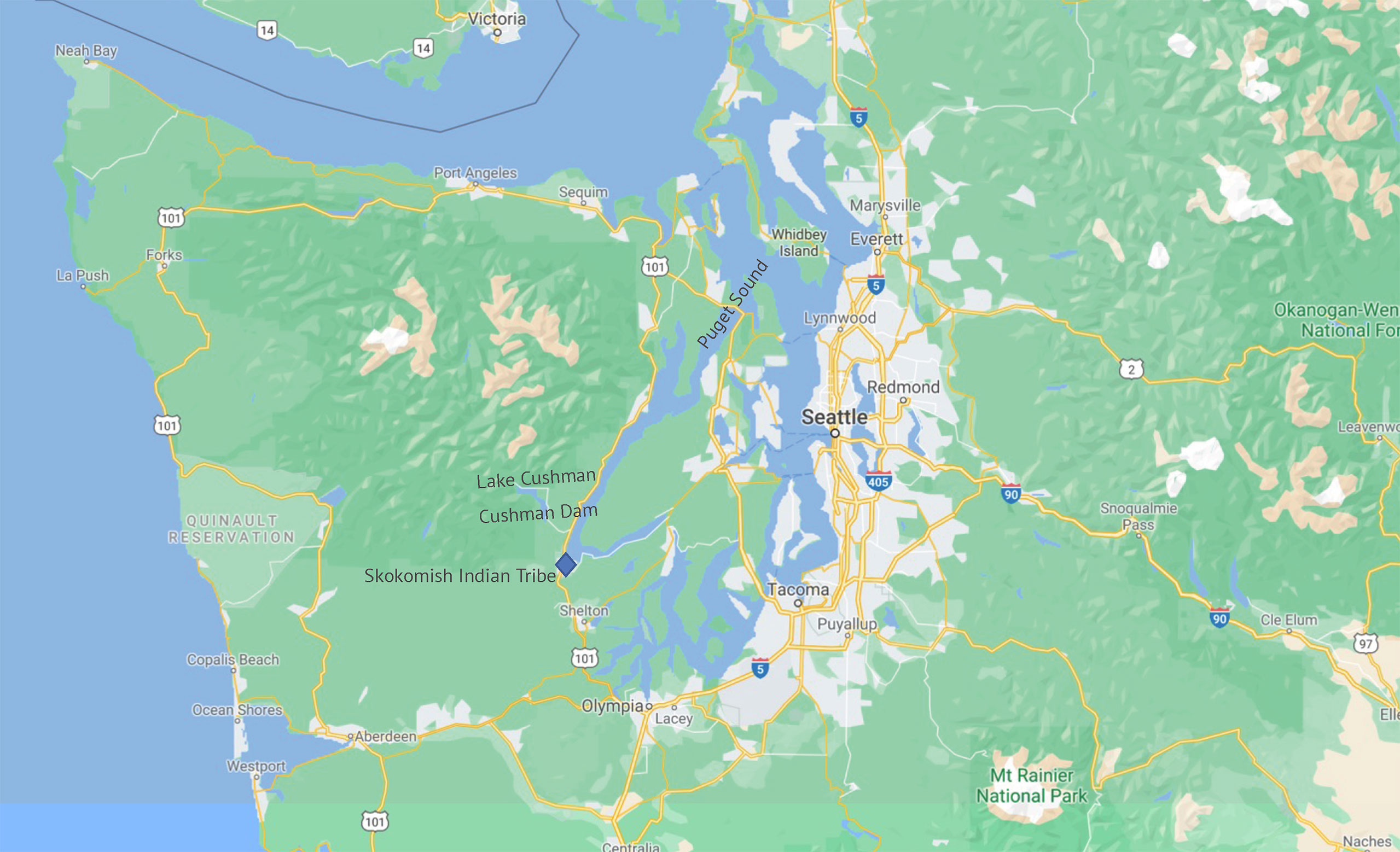
Figure 1 The Olympic Peninsula Region (Source: Google Earth).
The final glacier retreat about 14 KBP opened the land and surface water converting the ecology of the peninsula from the rocky bottom of a thick glacier to a lush landscape of forest, animals, and rivers (Gavin et al., 2013). Lenz, 2011 documents ocean levels rises and land rebounds from the removal of glaciers. By 13 KBP sea levels dropped to their lowest point, roughly 150m lower than today, and maintained that position until at least 12.4 KBP. This opened the Pacific coastal shelf for use by Indigenous peoples.
The Olympic Mountain massif has elevations of up to 7,962 feet and its own residual glaciers and is the center of the peninsula, which is situated among the Pacific Ocean, the Strait of Juan de Fuca, and the fiords of the Puget Sound. The ecological mixture of moisture laden ocean winds and extreme mountains made the peninsula one of the wettest ecosystems in North America. The coniferous forests contained large herds of elk and deer, and supported hundreds of plant species. Higher in the mountains, and depending on slope and soils, were other plant zones with the upper limit of tree growth being between 5,000 feet and 6,000 feet. These higher zones supported other kinds of plants and animals. The three coasts provided various river estuary and delta habitats with shellfish and sea grasses which grew along the mud banks. Turner and Bell (1971) provide a summary of dozens of ethnobotany species and their food use, their value in technology and medicine, and their role in religious ceremonies. In addition, sea and land birds nested in the tall stands of estuary grasses thus providing both food for people and ecosystem services for nature.
Post-glacial rivers are the focus of this analysis. Like other rivers on the peninsula, the Skokomish River became, during these times, the home of a people who recognize the cultural centrality of their location by calling themselves SqWuqWu’b3sh, which translates as the people of the river. The rivers were the living habitat and spawning grounds for many species of fish, especially salmon, which have been termed a cultural keystone species (Garibaldi and Turner, 2004; Colombi and Brooks, 2012) because of their centrality in the lives of Native people. By this, it is meant that salmon are vital to the existence, social structure, and identity of these Indigenous people, especially through harvest, trade, and salmon-centered ceremonies that confirm sustainable practices and contribute to the learning of traditional ecological knowledge and conservation values for new generations. The river delta supported an abundant variety of wetland and shallow marine species especially clam beds. The people stipulate that they were created near the marine edge of the Skokomish River Delta, thus they have been in this ecosystem since Time Immemorial.
Critical for this analysis are the fast-flowing rivers who (correct pronoun because they are living Beings) have their headwaters in the Olympic Mountains and their deltas around the shores of the peninsula. The Skokomish River, for example, moves from the mountains across hard complex bedrock carving canyons and forming water falls which flow into deep stone basins (Figure 2). The landscape produced by this elaborate interaction of hard rock and fast water became a primary foundation of Native American ceremonial life.
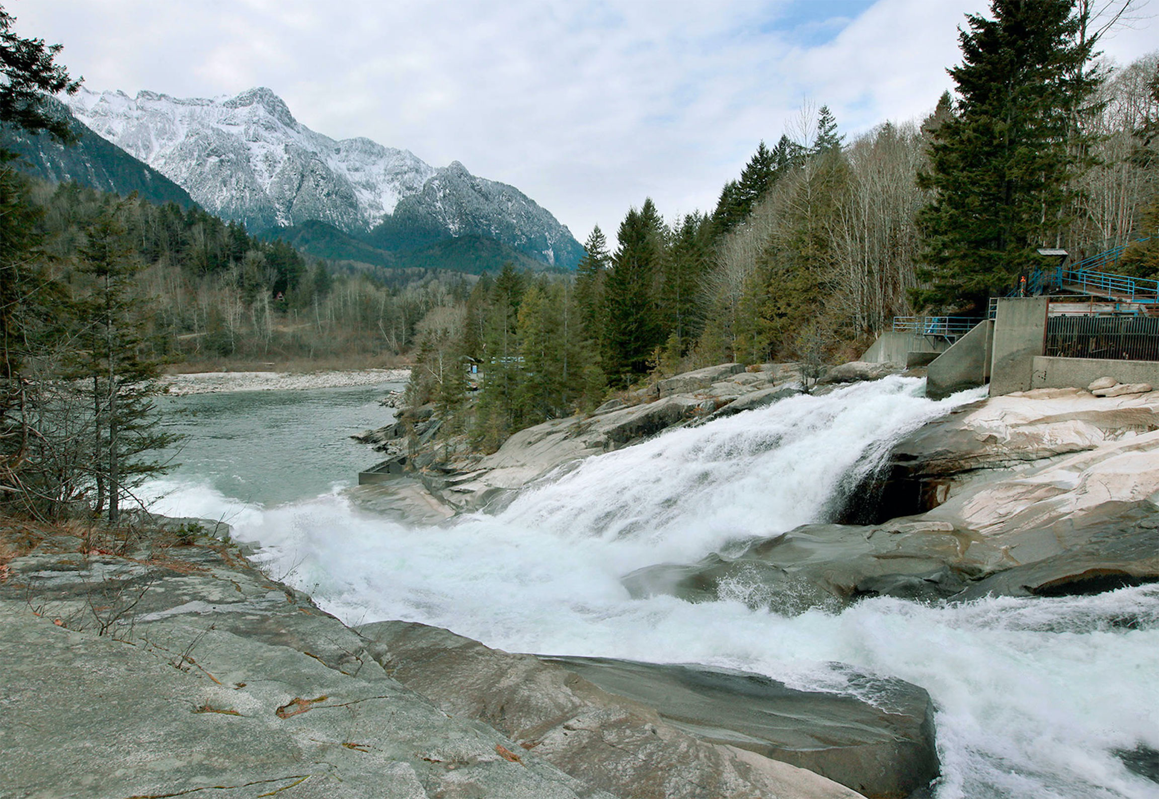
Figure 2 Sunset Falls on South Fork of the Skokomish River (Source: Sanders, 2021).
Just offshore were schools of pelagic fish and a variety of sea mammals. It was a complex and resource abundant ecological system that supported large numbers of Native American peoples who lived in complex societies, each with cultures that were sensitive to the sustainable use of nature (Trosper, 2009).
Current evidence document that for more than 10 KBP (Haggan et al., 2004; Lenz, 2011; McLaren et al., 2015) people lived on and around the peninsula where they developed large communities that were made possible by the abundant environment and human co-adaptations that both stimulated certain species, protected others, and preserved surplus foods so they were available throughout the year. Selective in terms of time and place, burning created local grasslands in the forest and stimulated the growth of different species of plants and supported larger herds of animals (Wray and Anderson 2003). Forest gardens composed of many species were maintained providing services to humans and animals and a special ecology for plants (Armstrong et al., 2021). People learned to remove wood and bark from living trees for arts, crafts, drums, canoes, and even homes without doing harm to the trees. Such trees are called today “Culturally Modified Trees” (B.C. Ministry, 2001). Guujaaw, a Haida carver, calls this pattern of drawing resources from the trees as “looking into the heart of the cedar and walking in the majesty of the great magician.” Culturally modified trees are recognized as heritage-signature places in the forest, which constitutes living archaeology, thus highlighting the long-term understanding of the trees, the development of Traditional Ecological Knowledge (TEK), and the ways that people have learned to live with trees without causing them damage (Stryd and Feddema, 1998).
People harvest seaweed from rocky intertidal zones and accomplished this task in a sustainable way, so as to stimulate the seaweed beds and make them healthier (Turner, 2003; Turner, 2016). Rocks were rolled to the shore to make walled structures called Clam Gardens (Deur et al., 2015). These stones formed tidal shore areas that provided a protected habitat for four species of clams (Groesbeck et al., 2014). The clam gardens are viewed by scientists as a special example of learning TEK in a nonintuitive ecological zone (Jackley et al., 2016). Critical to the rise of complex societies and cultures were the development of innovative ways to preserve surplus foods. Trosper (2009) in his book Resilience, Reciprocity, and Ecological Economics: Northwest Coast Sustainability, explains how the Indigenous societies living on the Northwest Coast manage to live sustainably with their ecosystems for thousands of years. Key to these co-adaptations were use of natural foods, which, along with expressive arts made largely from natural materials, became the foundation for an elaborate system of ritual exchanges often called the Potlatch, a ceremony which has come to characterize those held by all the peoples of this region (Barnett, 1938; Snyde, 1975; Jonaitis, 1991).
The Skokomish Cultural and Arts Committee (2002: 68) confirm with contemporary oral history the traditional use of all natural resources. They do not view humans apart from their environment or the spiritual world and emphasize that all life is interrelated. Even the mountains are alive. One day, according to oral history, Mount Rainier left her home on the Hood Canal near Quilcene because of an argument with her husband. As she traveled over the Skokomish River, she dropped some fish and that is why salmon began to run up the river (see Meany, 1920). The guardian spirits like mountains themselves were important expressions of Skokomish lifeways. Skokomish people went on quests for their guardian spirits to powerful places such as lakes, waterfalls, the talus slopes in the Olympic Mountains, along the rivers, and in the marine waters of Hood Canal.
Most scholars have described the people of the peninsula as having made major strides toward full co-adaptations with the natural resources, each other, and changes in climate. The land and its resources were changed by nature and humans over this 14,000-year period, and yet people learned TEK, developed value-based conservation practices, and created adaptive ways of life. These lifeways were both sustainable through time and resilient when confronted with short-term perturbations such as massive storms and seasonal weather shifts including droughts, as well as longer perturbations such as the Little Ice Age AD 1300 to AD 1850. The latter unraveled complex human societies around the world, but the people of this region persisted. While no human relationships with the environment are equally useful and sustainable for themselves and nature, scholars agree that Indigenous lifeways and their nature co-adaptations on the peninsula were sustainable relationships.
Colonial impacts to the environment and Indigenous peoples are well. European societies gained world prominence due to their 400 year-long expansion around the world through military conquest, establishment of complex trade relationships, and the relocation of people to serve as unfree laborers. Colonies served the mother country by sending local resources back to Europe to stimulate those economies and provide a unique power base. Colonies were set up to serve their owner. Whether colonists engaged in direct extraction of furs or produced industrial agricultural products like sugar, the colonies were not made for local people who were generally in the way unless they could provide labor for a European purpose. Colonies initially were governed by a few Europeans and subsequently staffed by their children and local people who would serve as needed (Sunseri, 2017).
Settler Colonialism (Hurwitz, 2014; Gahman, 2016; Inwood and Bonds, 2016) represents a variety of territorial incorporations by foreign nations wherein the mother country encouraged the migration of Europeans to achieve a local balance of power or increase production. This occurred for various reasons, but often it did so when the local people died off due to diseases and thus were no longer available for unfree labor. In general, the European migrants to the colonies were poor or powerless and had to repay the costs of their transportation with subsequent labor. Millions in Africa were taken by force and moved to colonies where they were needed as enslaved workers. Other forms of labor recruitment and agreements were developed for people from China and India. Some settlers were attracted by government-approved businesses that were paid to organize offers of free or low-cost Native lands and resources.
In North America, Indigenous people were overwhelmed by settlers and other free laborers who were encouraged by European governments to move into and occupy Native lands. Resource-rich areas like the Pacific Northwest would become very attractive to settlers who would produce food and forest products for others who were in turn directly attracted by mineral extraction and trade.
When European colonial empires moved towards the Pacific coast of North America in the 1700s, the Russians were already there, and Cook explored the area for the English on his third voyage in 1790. Spain established settlements along Baja California but explored our study area as early as Mozino documented in 1792 (Wilson, 1970). In the mid-1700s a Spanish exploration ship found the Bay of San Francisco and just to the north was a Russian settlement. This stimulated the Spanish government in 1776 to send Juan Batista de Anza to establish the Presidio de San Francisco with a few mixed-race and multilingual settlers from northern Mexico (Stoffle et al., 2011). This was at the time the northernmost Spanish settlement. Anza specially trained these settlers to work together with each other and in positive cross-cultural ways with the native residents. His settlement was successful, but the native peoples of San Francisco Bay would largely die from diseases.
Many scholars assert that European diseases were the primary reason why European colonial expansion was successful in the New World. For example, the War of the Rebellion against England by the settlers of the 13 American colonies (1776 to 1783) resulted in the best documented early smallpox pandemic in North America. Arisen in Mexico City, the disease spread up the Camino Real to Santa Fe, New Mexico and eastward onto the High Plains and up into the Great Lakes (Fenn, 2001). To the west, it spread up the Colorado River to the Snake River and then downstream to the Columbia River and to the Pacific coast and then north to the Olympic Peninsula and Puget Sound (Harris, 1994; Harris, 1997). The pandemic spread further up the Fraser River and throughout British Columbia along river-based Native American trade routes. It generally killed half to 85% of the people in each village it infected. When Vancouver first arrived in the region in 1792 on his expedition to map the Pacific Northwest for the English (1791-1795), he was amazed to find carefully managed shorelines with abandoned settlements, many having only a few people, which in retrospect we know were then a post-pandemic recovering population. Another massive smallpox episode occurred in 1862 taking out many more of the native peoples (Nicholson (aka ‘Tayagila’ogwa), 2017; Ostroff, 2017).
European colonies would converge on the region in the mid-1800. The U.S. would expand its territory with the Louisiana Purchase in 1803, and tens of thousands of settlers would cross the Mississippi River. Western Spanish territory was extinguished by the Treaty of Guadalupe Hidalgo in 1849, thus extending U.S. territory to the Pacific Ocean. Gold was discovered at Sutter’s Mill in California in 1848, beginning a worldwide gold rush to the Pacific Coast. San Francisco would grow creating an almost unlimited demand for wood and fish. Seattle was formally established in 1855 and would thrive on exporting fish and wood from old growth forests to coastal communities to the south. Many trees in the old growth forests were from 1,000 to 2,000 years old. In 1873 Tacoma was selected as the terminus of the North Pacific Railway making it the final destination of their transcontinental railroad, thus creating a land-based means of exporting natural resources and providing easy and affordable access for settlers and traders. The environmental future of the region was set.
Native ceremonies and religion were the moral and principal foundation for natural resource conservation, so it was disastrous when they were suppressed by settler governments in both Canada and the U.S. As part of a policy of assimilation, the Canadian federal government banned the potlatch from 1884 to 1951. The government and its supporters saw the potlatch ceremony as anti-Christian, reckless and wasteful of personal property. Native American ceremonies were banned after the Ghost Dances of 1869 and 1880 by the U.S. federal government. The U.S. Religious Crimes Code of 1883 banned native dances and ceremonies, including the Sun Dance, Ghost Dance, potlatches, and the practices of medicine persons. The Code gave Indian agents authority to use force, imprisonment, and the withholding of rations to stop any cultural practices they deemed immoral or subversive to federal government-mandated assimilation policies. Courts of Indian Offenses were created as well as Indian police forces, established, paid for, and supervised by the federal government to replace Native governance. Legal suppression of ceremonies where religious principles were both enacted and used to maintain balance in the world is the functional equivalence for a Native people of clearcutting their 2,000-year-old growth forest.
Dams constructed in the first quarter of the 20th century were a tipping point for the Native American peoples and their environments in the Northwest Coast region and similarly much of the western United States. Faced with massive land additions in the 1800s, the still young U.S. government developed a thesis that its destiny depended on civilizing the wild rivers of the west and putting them into the service of the nation. Dams were the solution; they were part of what Joyce (1997) calls a dam building fever that encompassed the globe. During this period, national leaders viewed them as the new “temples of development, monuments to a nationalistic vision of modernization and unlimited growth.” National economies in fact were vigorously stimulated by their construction (Wilson, 1973, Joyce, 1997).
Titled The Colorado River: A Natural Menace Becomes a National Resource, a report to the U.S. Congress outlined plans to dam most western U.S. rivers, especially the Colorado River (Bureau of Reclamation, 1946). Dams were proposed in this report to be constructed throughout the Colorado Plateau watershed of the river, flooding even the Grand Canyon. Contemporary Native people were depicted in the report as either practicing primitive irrigation or roamed hunting animals and collected herbs. According to this report, the Utes and Paiutes were among the least progressive of all Indian peoples and thus, need not be considered when planning dams. The irrigated agricultural systems of the Native Americans who traditionally lived along the Colorado River and up each of the side rivers were viewed as a water-right issue that would not be addressed by the Bureau of Reclamation (BOR). At the same time, the BOR requested from Congress the permission and funds for multiple dam constructions which would flood these Native farms and communities.
Dam constructions on the Columbian Plateau paralleled those planned for the Colorado Plateau. Columbia River flows were initially modified by a digging a bedrock canal at the Dalles and Celilo Falls (1905-1915), which permitted the passage of steamboats (Land, 2007). At the ceremony that opened the canal, it was said that the canal was the first of many that would free the river from economic and physical restrictions, thus reifying the vision of a completely reorganized and controlled river.
The canals were followed by dam proposals despite a massive and economically profitable fishery and cannery system located the Dalles, Celilo Falls and elsewhere along the Columbia River (Land, 2007). In the early 20th century, the State of Washington and private industry developed various proposals for a dam at this key constriction in the river (Land, 2007). Dam construction plans were prepared in 1912 by engineers for the Portland General Electric Company who already owned six hydroelectric stations and nine steam plants (Land, 2007). The new dams were argued for in terms of electricity and industrial growth rather than fish. A 1932 government report on the Columbia River plotted 10 mainstream dams, each at a promising power generation and navigation-enhancing location (Land, 2007). Figure 3 documents the complexity of the dam proposals and patterns similar to those proposed for the rivers of the Colorado Plateau.
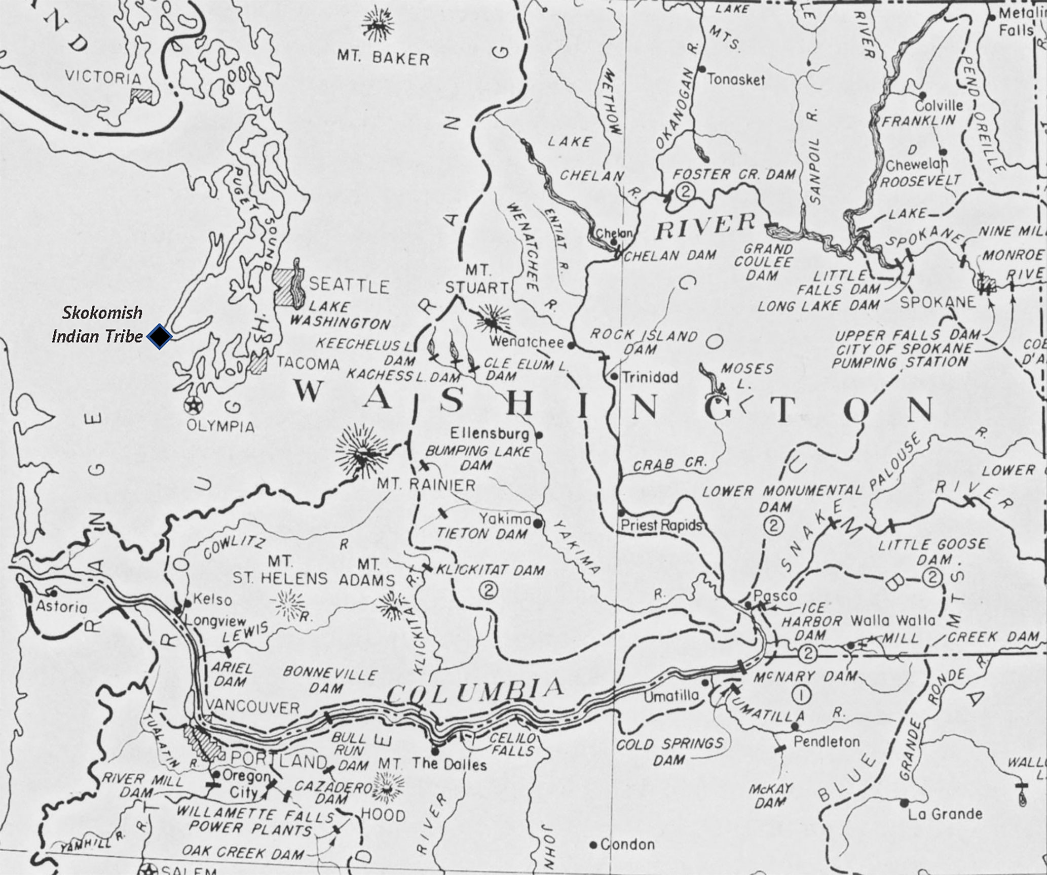
Figure 3 Proposed and Completed Dams on the Columbia Watershed (Source: U.S. Army Corps of Engineers 1948, Originally 1932).
Building two small dams on the North Fork of the Skokomish River may seem a minor event given the massive national, state, and industrial investments in dams throughout the western U.S. These two dams, however, are best understood in the context of U.S. national rhetoric regarding taming the west and advancing civilization. Within this larger discussion is a simultaneous recognition of adverse impacts of water impoundments to Native American people and their livelihoods and a dismissal of these concerns because Indians only stand in the way of progress (Boyd, 1999; Decker, 2004). The case of the two Skokomish River dams accurately represents the local Native anguish and resistance to dams on their river. They serve as a comparison and illustration to what occurred throughout the western U.S.
The diagram in Figure 4 provides some detailed information needed to understand the Skokomish dam case. There we see the watershed boundary with elevations and thus understand why the two Skokomish Rivers who drop from up to 6,233 feet to sea level in just 33 miles are fast flowing. The resulting delta traditionally was one of the most ecologically productive ones in the region.
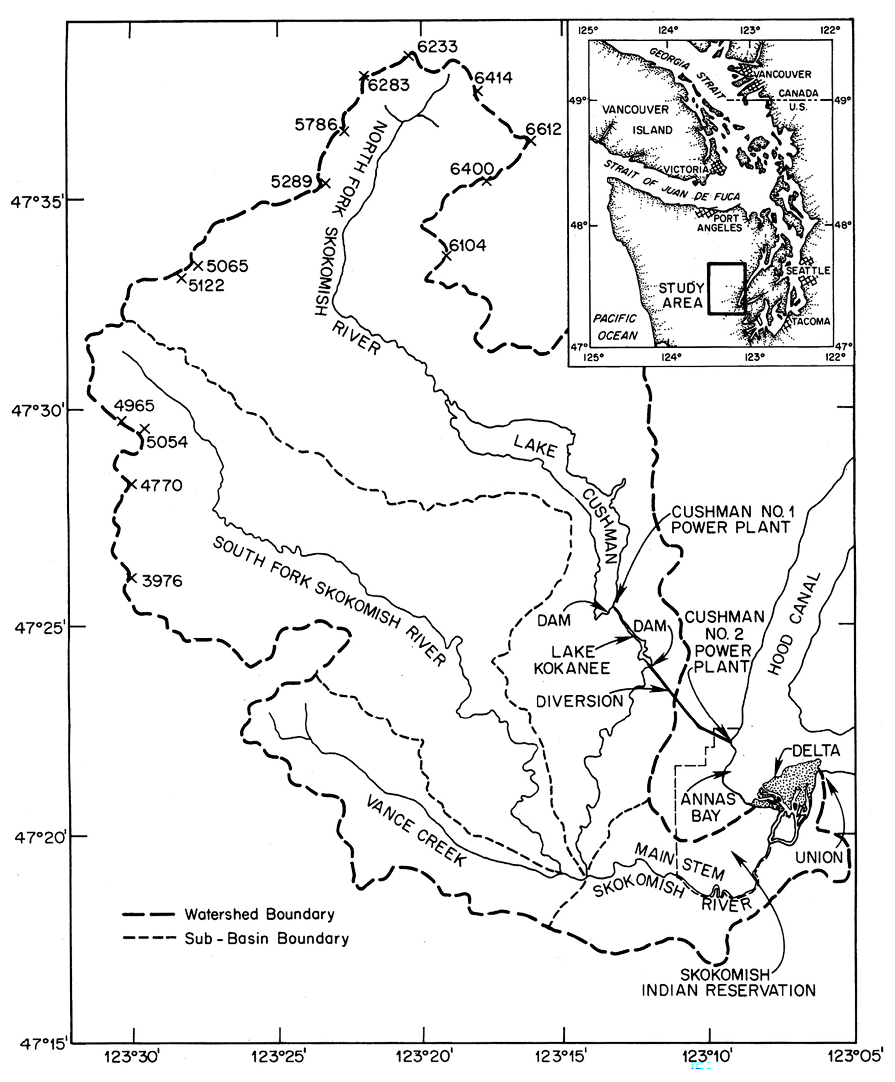
Figure 4 Local Watershed Map (Source: Jay and Simenstad 1996).
This case begins with the Cushman Project, which consists of two dams and hydroelectric power plants that utilize the flow of the North Fork of the Skokomish River (Figure 4). The first dam that was constructed in 1926 contained facilities to generate electrical power (Figure 5). Downriver a second dam was completed in 1930. This one was designed to divert most of the remaining river out of its basin and transport it via pipe to a remote power plant on a high cliff above the Hood Canal. This out-of-basin diversion dewatered the North Fork below the dam and reduced down river flows in the main stem of the Skokomish River, which runs through the reservation into a large delta and into the Hood Canal (Figure 6). One of the hydroelectric plants is located within the boundary of the 5,000-acre Skokomish Indian Tribe reservation on land now owned by the city of Tacoma. A TWP access road and transmission line run across reservation property.
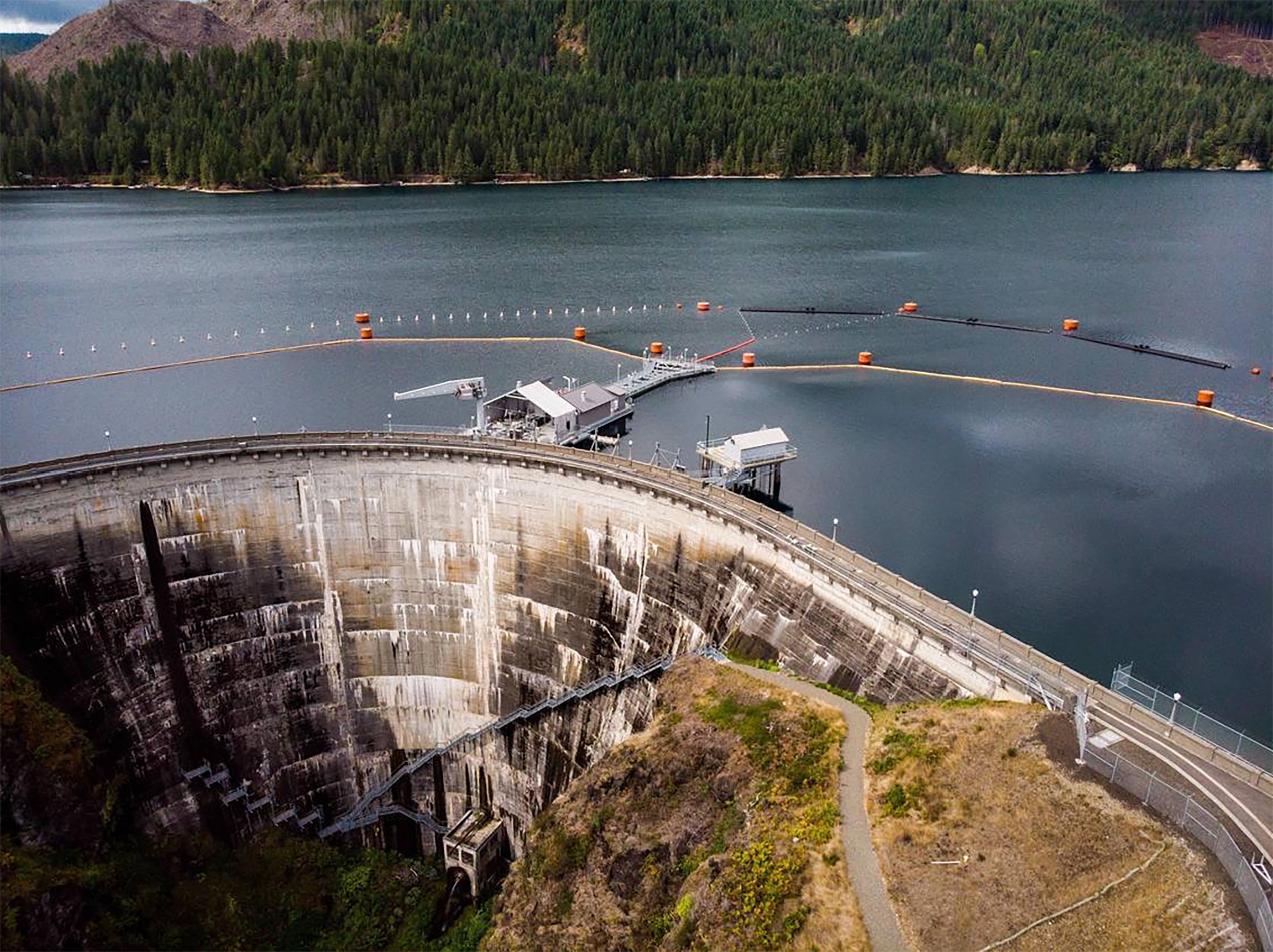
Figure 5 Cushman Dam Number 1 (Source: Tacoma News Tribune, 2022).
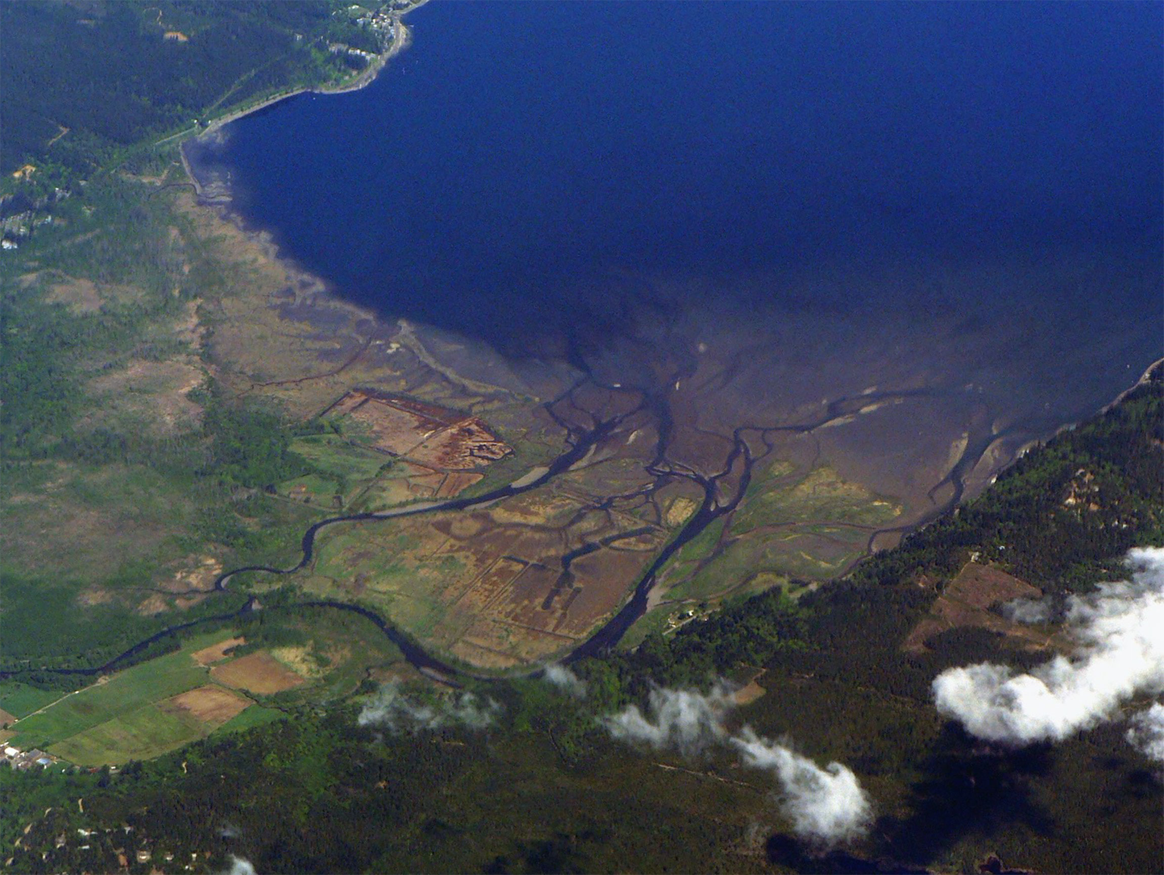
Figure 6 Skokomish River Branches Join to Form a Delta on Hood Canal.
The Skokomish people protested the dams and their perceived adverse impacts to an aboriginal cultural landscape and Native lifeway. There is no evidence that during the interim 52 years since the dams were built that TWP seriously considered these expressed concerns. Then in 1998 when the Federal Energy Regulatory Commission (FERC) had to issue a new operation license for the TWP facility the concerns were registered. In that new license FERC imposed several conditions to protect the environment, to remedy past environmental impacts, to restore fish populations and to otherwise mitigate the effects of the project on the tribe and their reservation. These conditions included maintaining a minimum flow in the river of 240 Cubic Feet Per Second, a rate that TWP asserted would shut down the project making it more costly to operate than its value. Under section 4(e) of the Environmental Protection Agency regulations, FERC is required to protect federal reservations and their use.
TWP remained in court preventing the new license from being implemented. One TWP argument was that putting water back into the river was largely useless because it could not be restored; in other words, it was dead. The tribe also counter-sued, claiming FERC and TWP violated various assessment procedures.
The tribe strengthened their original and persistent argument that the river remained a cultural landscape by engaging three cultural anthropologists. Each scholar was tasked with conducting an independent assessment of “Whether or not the river was dead (the author’s words) and if so, what was it worth?”
According to Lansing et al. (1998) , it would be easy to conclude that the value of the river to the tribe simply cannot be determined within the framework of Western economics; indeed, this thesis had often been advanced by attorneys for the utility company. However, an assessment of the value of the river based entirely on its power to drive turbines is no more than a book-keeping convenience, illustrating not the power but the limitations of conventional economic analysis. Clearly, it was necessary in the Skokomish case to find ways to think about the value of natural resources or natural capital that can accommodate complex ecological and social processes. See Jiang and Marggraf (2021) who more recently conducted a similar assessment of the cultural ecosystem services of the Weser River in Germany.
The Lansing et al. (1998) analysis describes a framework, within which it is possible to assess the value of the Skokomish river as a form of natural capital to the Skokomish people. Based on his interviews with Skokomish elders, Steven Lansing developed an original integrated model using the variables the elders identified. Steven Lansing argued that natural capital analysis also includes all that is encompassed by the concept of social capital defined by Putnam (1995) and thus assigns economic values to features of social organization such as networks, norms, and social trust that facilitate coordination and cooperation for mutual benefit.
The diagram in Figure 7 was produced by Lansing et al. (1998) to model 18 natural and cultural dam impact variables and some of relationships between them. The diagram, which is the basis of their analysis, includes topographic, ecological, economic, social, and spiritual/cultural variables and their mutual impacts. Theirs was an effort to holistically model the impacts of the Cushman project. Their model highlighted the foundational components of the legal and public debates over whether to restore the North Fork of the Skokomish River, including the delta.
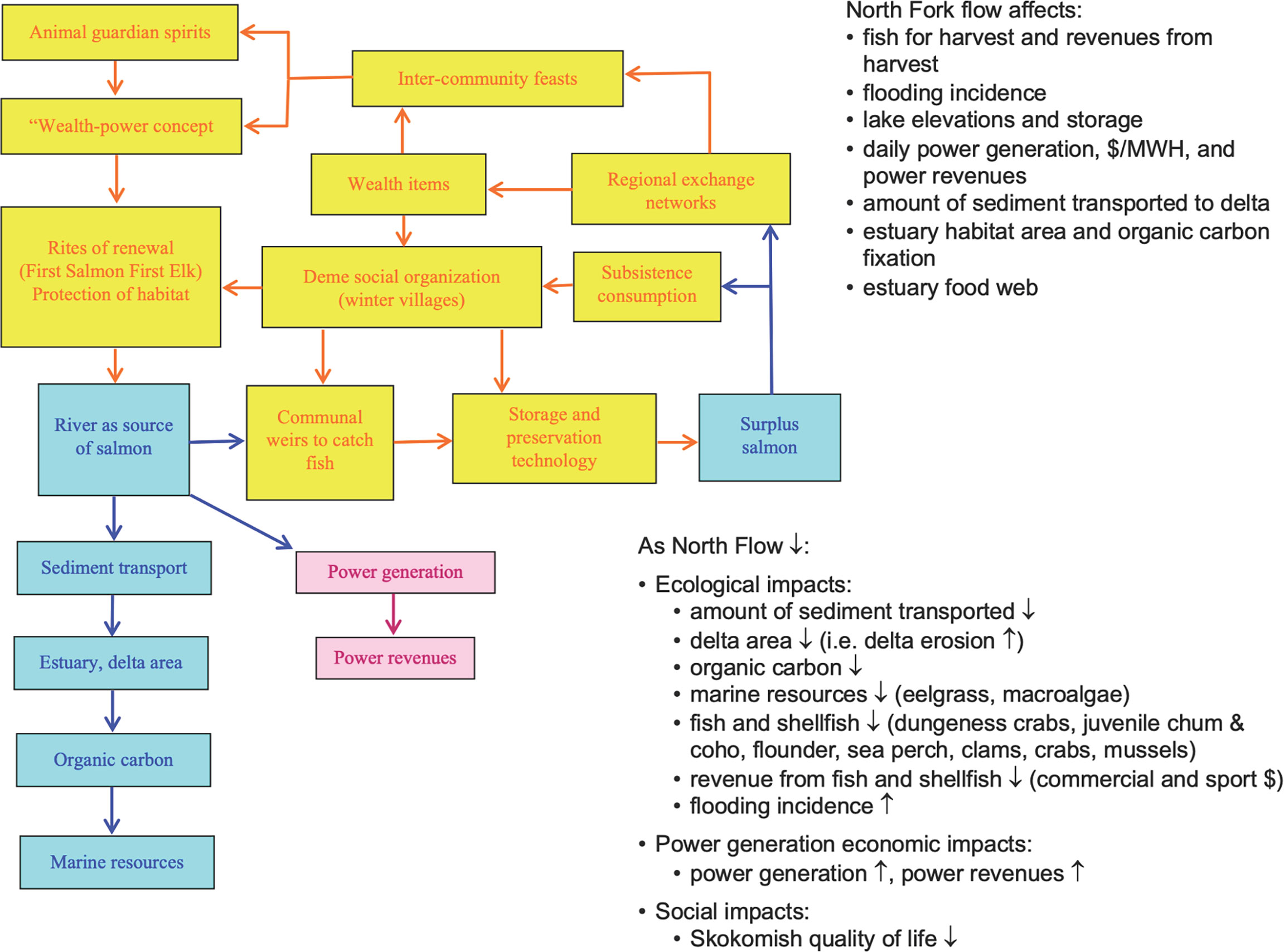
Figure 7 Model of 18 Impacts (for details on the meaning of the color codes see Lansing, Lansing et al., 1998).
Lansing et al. (1998) conclude that this economic anthropology assessment served two ends: (1) first, it described the benefits that could be obtained by returning the river to its natural channel and (2) second, it developed a method to estimate the magnitude of the losses sustained by the tribe. These impacts to the “from Time Immemorial way” of life included fishing for salmon in the river, hunting for elk and waterfowl along the riverbanks, gathering shellfish and grasses for baskets at the river estuary, and seeking the spiritual visions and religious experiences of the Skokomish people that occurred at sacred sites along the course of the river.
The second senior cultural anthropologist provided expert testimony that the Skokomish River, including the entire North Fork, qualified as a TCP of the Skokomish people. Important in this assessment was a National Register of Historic Places (NRHP) nomination criteria that the heritage place under consideration should have maintained its original integrity (Parker and King, 1992), which of course was the key legal issue in the Skokomish River case.
The concept of a Traditional Cultural Property (TCP) is nationally recognized in law and regulation (Parker and King, 1992). According to Parker, 1993, a traditional cultural property is a place that is eligible for inclusion on the National Register of Historic Places because of its association with cultural practices and beliefs that are (1) rooted in the history of a community and (2) are important to maintaining the continuity of that community’s traditional beliefs and practices.
The TCP designation was developed as a vehicle for identifying, defining, and protecting places that arguably have national heritage significance but only qualify for this designation by using ethnic group criteria, rather than archaeology or history data. After much debate the concept was formalized in NPS Bulletin 38 which included both the arguments for such heritage designations and the methods for establishing their existence (Parker and King, 1992). Heritage research methods such as those employed by anthropologists are essential because TCPs are normally without anthropomorphic features; in other words, they are the mental artifacts not the physical artifacts of a cultural group (Stoffle et al., 2020). As a social construction, a TCP only exists in the culture of a traditional or aboriginal people.
Cultural places can be understood as an interconnected landscape, and as such, their individual values contribute to the overall magnitude of importance of a heritage area to an ethnic group. TCPs tend to be smaller in size and homogeneous in cultural composition; whereas cultural landscapes contain a variety of resources such as places of historic importance, topographic features that contribute to ceremonies such as vision questing, and the natural resources like fish, water, plants, and animals (McClelland et al., 1989:16, 27). TCPs must be bounded during nomination to the NRHP whereas landscapes are, by definition, much larger with indistinct edges. These are often referred to as “Vernacular landscapes that are the result of past human activities, land uses, and choices. Ethnographic landscapes are typically vernacular landscapes that contain natural and cultural resources that are associated with a people who define them as heritage resources” (CTOT, 1999:6-7). Landscapes have indistinct boundaries because they are social constructions, which contribute to the meanings of their functional components and their relationships with one another (Stoffle et al., 2020). Pilgrims often travel along a waterway such as a river celebrating places and resources as they move towards a primary destination such as a mountain (Van Vlack, 2014; Van Vlack, 2018), which often is the hydrological origin of a river (Stoffle et al., 2004; Stoffle et al., 2015).
Native American cultural landscapes can be recognized as protectable heritage places and, like TCPs, are recognized as eligible for the National Register of Historic Places (NRHP). Both TCP and cultural landscapes nomination to the NRHP need to be documented as existing in the culture of a people: that is, a contemporary Native American ethnic group. Unlike TCPs, however, landscapes have more components and are spatially larger, so the NRHP nomination research must be more extensive and better explain the cultural significance of both the landscape components and the spaces between them.
A cultural landscape heritage model was chosen by Stoffle (the author of this paper) because it best fits the statements shared by tribal members (Stoffle et al., 2003). Discussions were guided by both TCP and Landscape perspectives, which is a research procedure developed during the Glen Canyon Water Release studies in the Grand Canyon (Austin and Drye, 2011). In this field study six research trips with Paiute elders documented the many kinds of places and resources that were integrated into various kinds of landscapes along the Colorado River (Stoffle et al., 1997). All landscapes were integrated by physical and spiritual trails, along which pilgrims and ceremonial participants traveled to destination places such as salt and paint caves, hot springs, women’s healing sites, and even a volcanic plug at Lava Falls located in the middle of river itself used for healing by known medicine people.
Skokomish elders and other tribal members spoke of the Skokomish River as being the center of these kinds of traditional activities and having culturally special places along its length. Their cultural interpretations correspond with those expressed by other native people during the Colorado River. These stipulations thus argued for the Cultural Landscape concept as a the most accurate heritage model to explain and interpret Skokomish relationships with their river. Stoffle et al. (1997) also maintain that river and canyon cultural landscapes can maintained their original integrity despite the impacts from dams.
All three anthropological expert testimonies were independently submitted to the Tribe and incorporated by them into their ongoing debates with TWP over the cultural meaning of the North Fork of the Skokomish River and potential ways it could be restored. The anthropological findings contributed to both formal and informal discussion between the tribe and TWP. In retrospect, there was a clear agreement between the three anthropological approaches about the persistent heritage value of the river and the many cultural and environmental services it performed, still performs, and will perform for the Skokomish people. These anthropological findings strengthened the tribe’s position.
The three anthropological assessments went beyond simple descriptions of past events to argue for the integrated understanding of natural and social ecosystems services that are performed by the Skokomish River. Building on the explicit model by Lansing et al. (1998), the studies provided both qualitative and quantitative approaches needed for a holistic understanding of the relationships of natural and social services impacted by the TWP dams and the possible path of recovery that could be a foundation for re/establishing the traditional relationships between the river and the Skokomish people. These analyses went beyond social and natural capital in that they considered the presence of a broad spectrum of ecosystem functions. As such, they provided an early model of what is termed today Sustainability Ecosystem Assessment (Bond et al., 2013), Siting Risk Assessment (Boholm and Löfstedt, 2004), and Integrated Environmental Assessment (Bond et al., 2001). The analysis supports the discussions of the Protected Landscape Approach, Category V of the International Union for Conservation of Nature, World Commission on Protected Areas (Brown et al., 2005).
The Skokomish people maintained that the integrity and thus the cultural significance of the Skokomish River remain intact despite the physical modifications of the two Cushman Lake dams. The sacredness of the river was defined in its Creation which made it timeless. Subsequent modifications are only temporary and will be removed in time by the river itself. Only the Skokomish people can maintain this epistemological stipulation. The anthropologists concluded that the North Fork of the Skokomish River qualified as a cultural landscape with TCPs along its length, and these all were still in existence and not eliminated by lake flooding and dewatering.
Now three decades after the Cushman Legal Case and a hundred years after their protests of the initial dams, the Skokomish people have more to say in actions that influence the North Fork of the Skokomish River. The river itself has considerably more water running in its lower course. The delta benefits from increased water amounts and more nutritious flows, and there are salmon and other fish spawning again. The two Cushman Dams remain: the upper North Fork River is partially a lake and lower down river some water for electrical production is still removed. Spawning is facilitated by capture and transport of adult fish from the delta to the upper portion of the river above the dams. This action is followed by a similar process of moving 1.8 million baby fish back below the dams for release in the waters of Hood Canal. News articles cover restoration activities while TWP and Tribal Representatives pose for photos with the caption “working together” (Royal, 2015). Some common ground has been achieved. The Skokomish Indian Nation and the Mason Conservation District are engaged in a plan to restore, manage, and monitor the Skokomish River Delta (Salishi Sea Wiki, 2022).
Mr. Joseph Pavel, Director of the Skokomish Natural Resources Department agreed to share his perspectives on restoration. According to Mr. Pavel (2021):
Federal Energy Regulatory Commission, the Cushman Project licensing was kind of the nexus for the Skokomish to bring us all to the table, eventually, at some point. The Skokomish Tribe certainly struggled long and hard to get a place at that table and we struggled long and hard to get some of our trustee agencies to engage in their fiduciary responsibility which is required of them under the laws of the United States.
Our objective was to resolve and mitigate some of the impacts that we saw from the project on the river and consequently on the tribe itself. We now have about 40% of the natural flow in the river and have special releases to increase soil deposits in the delta. We also are raising fish and catching spawning ones. We have constructed two hatcheries one is for Sockeye salmon with the objective to release Sockeye at the end of the lake. The other hatchery’s objective is to restore the extinct spring Chinook Salmo spawning run by releasing them into the river. The Spring Chinook program has a licensing requirement to release 370 5000 juveniles annually and the Sockeye program is required to release up to 2 million juveniles annually.
We are engaged in bringing back the Delta. We’ve implemented an expensive restoration project down there into the Delta, so it is been pretty much effective. I would say as much as practically possible given we still have utility facilities and a power line with tower footprints across it. We also do not have all the flow of the river. You know so it’s on the away back to an undisturbed, or to the pre-disturbance state. It’s pretty much has been restored back to the natural intertidal. It’s a real challenge you know we have ongoing engagement; you know we have an Interagency Committee that kind of provides some oversight to that – yeah, it’s a challenge.
It is a real struggle trying to get a foothold when we try to bring these fish in here. And you know it just doesn’t happen, I think people are not aware of the complexities of the situation when you say, “good we will just build a fish hatchery and go fishing.” It doesn’t work that way. We have a lot of endangered fish species and all those considerations, so it’s not business as usual anymore that’s a new paradigm. Some Endangered Species (ESA) are doing well in the lower portion of the rivers. You know there’s a number of complex issues with respect to fisheries and their management in a new river.
As far as a tribal business enterprise there’s no engagement in the fisheries. Obviously, we expend significant amount of investment in the management of the resources and management of the fisheries, but as far as an enterprise the tribe is not engaged in that. We have some tribal members that are engaged in fish enterprises and then, of course, I would consider that every single fisherman out there is a small business owner.
The progress towards co-management and restoration occurred in part because (1) the Skokomish people have continued to maintain that they have a Creation-based responsibility and aboriginal right to protect and manage their river-based homeland, (2) lawsuits and agency appeals have kept the Cushman Dams under review and in the public eye, (3) national perceptions have shifted regarding the environmental role of dams and the proper place for Native Americans in their aboriginal lands, and (4) the dams have aged.
Lawsuits and appeals slowed the process of restoration, but the Skokomish Tribe made steady inroads and some tribal members said they were successful. Over time many local, state, federal agencies and non-Governmental Organizations became involved in the debate. Referring again to the model diagram (Figure 7) that displays the 18 variables. Currently one or more federal and state agencies are required by law and regulation to participate in public policy decisions when these 18 variables are involved. Nationally today there are more legal and regulatory arguments for restoring natural ecosystems and re/engaging Native American with their aboriginal resources including Presidential Executive Order from Clinton (EO 13175) and Memorandum on Tribal Consultation November 5, 2009 by Obama. While multiple and often overlapping agency jurisdictions can tie up decisions, these also increase the probability that one or more of these agencies will insist on full considerations of tribal concerns (Stoffle et al., 2004).
The Skokomish legal actions have contributed to a reconsideration of federal Environmental Assessment policies. According to Inside Washington Publishers (2006) a federal appellate ruling could force the Federal Energy Regulatory Commission (FERC) to reconsider its process for determining whether its hydropower licensing decisions harm water quality, according to industry and environmental sources. The ruling could also bolster state and activists’ efforts to protect water quality by forcing FERC to consider federal agencies’ environmental and other concerns—no matter when they are submitted—during the hydropower licensing process. And the ruling says for the first time that FERC may issue “uneconomic” licenses, or licenses by which environmental requirements result in the de facto decommissioning of the project. So ruled the U.S. Court of Appeals for the District of Columbia Circuit ruled Aug. 22 in City of Tacoma v. FERC, et al.
Soon after the Cushman Dam case in 2003, FERC issued a Policy Statement on consulting with Indian tribes. This policy was updated and expanded in 2019 (FERC, 2019). The FERC implemented this policy soon after the Cushman Dam case, suggesting a possible causal relationship.
National rhetoric has shifted towards the restoration of rivers, and the dams have aged. According to Hammersley (Hammersley et al., 2018), approximately 85% of dams in the U.S. will reach the end of their operational lives by 2020 (Doyle et al., 2011). As more dams age, the costs of repairing often outweigh the benefits of removing them before they fail. These conditions have stimulated formal actions by environmental groups and tribes to restore formerly altered river ecosystems (Whitelaw and Macmullan, 2002). Dams are no longer argued as the symbols of civilization. Instead, they have been documented as severely altering valued ecosystems and human adaptations.
The value of altering water release agreements and removing dams to improve and restore river ecology is now recognized and increasingly being put into action. At the northern end of the Olympic Peninsula the 45-mile-long Elwha River dam removals have become a model for restoration. This project occurred with the support from the Lower Elwha Klallam tribe, the Olympic National Park, environmental organizations, and local communities. To the south in Oregon a second larger removal project involves the four lower dams on the 250-mile-long Klamath River. This restoration is now the largest dam removal project in the U.S. Like the Elwha River removal, it occurred after many legal, regulatory, and moral public actions by the Klamath Basin Tribes (Klamath, Karuk, Hoopa and Yurok). Unlike the Elwha removal, however, the larger scale Klamath River restoration process is mostly guided by the Klamath Basin Renewal Corporation and the involved multiple states. Federal approval was needed but these agencies lacked the resources for the restoration. Thus, the removal actions were guided by the Klamath Basin Restoration Agreement. The initial $340 million dollar restoration price was paid by electrical utility users and through a citizen-approved water bond passed by California voters.
The Skokomish people continued to stipulate that their epistemological principles are the truth (that is veristic) and the river is alive a cultural belief that is common among Native peoples in North America (Stoffle et al., 2016). While such cultural stipulations have always created an epistemological divide between themselves and others, cross-cultural communications in environmental disputes have become an essential component of federal policy decisions (Sjölander-Lindqvist et al., 2022). Spiritual and other cultural principles now are considered along with economic and geology variables when assessing the impacts and benefits of environmental actions in the U.S. The analysis argues that the scale of restoration influences who does the work, but the decision to modify water release or remove dams very much derives from the efforts of environmental organizations, an increasingly environmentally sensitive public, and vocal Native American tribes.
Eventual restoration of the Skokomish River and the cultural roles it traditionally provided necessitates identifying and measuring the adaptive capacity of all related groups and agencies. This process has been extensively discussed by Whitney and a dozen other scholars in an article entitled “Adaptive Capacity: From Assessment to Action in Coastal Social-ecological Systems” (Whitney et al., 2017). Although any restoration model must fit the time, resources, and people, this model is a potential way forward to a fuller restoration of the Skokomish River and its people. Clearly upholding the traditional ecological knowledge and conservation practices of the Skokomish people will be a key in successful restoration, as Turner and Spalding (2013) maintain in their restoration article called “We Might Go Back to This: Drawing on the Past to Meet the Future.” These findings support the Protected Landscapes Approach suggested in Category V of the International Union for the Conservation of Nature (Brown et al., 2005). Like the current case analysis that approach argues that landscapes are best protected when they link nature, culture, and community. Especially important is the engagement of people who have lived in the landscape in order to foster their stewardship (Brown et al., 2005).
The original contributions presented in the study are included in the article/supplementary material. Further inquiries can be directed to the corresponding author.
Written informed consent was obtained from the relevant individual(s) for the purpose of this study.
The author confirms being the sole contributor of this work and has approved it for publication.
The work was completed by RS as a part of his position as an anthropologist. It was considered by the University of Arizona as voluntary community service.
The author declares that the research was conducted in the absence of any commercial or financial relationships that could be construed as a potential conflict of interest.
All claims expressed in this article are solely those of the authors and do not necessarily represent those of their affiliated organizations, or those of the publisher, the editors and the reviewers. Any product that may be evaluated in this article, or claim that may be made by its manufacturer, is not guaranteed or endorsed by the publisher.
The author acknowledges the trust and participation of the Skokomish elders and government representatives. Especially important was Mr. Joseph Pavel, Director of the Skokomish Natural Resources Department who agreed to share his perspectives on restoration. Dr. Kathleen Van Vlack and Heather provided editorial support and revised some of the figures.
Armstrong C., Miller J., McAlvay A., Ritchie P., Lepofsky D. (2021). Historical Indigenous Land-Use Explains Plant Functional Trait Diversity. Ecology and Society 26 (2), 6. doi: 10.5751/ES-12322-260206
Austin D., Drye B. (2011). The Water That Cannot be Stopped: Southern Paiute Perspectives on the Colorado River and the Operations of Glen Canyon Dam. Policy Soc. 30, 285–300. doi: 10.1016/j.polsoc.2011.10.003
Barnett H. G. (1938). The Nature of the Potlatch. Am. Anthropologist 40 (3), 349–358. doi: 10.1525/aa.1938.40.3.02a00010
B.C. Ministry (2001). “Culturally Modified Trees of British Columbia: A Handbook for the Identification and Recording of Culturally Modified Trees,” in Archaeology Branch, B.C. Ministry of Small Business and Culture (Canada: Government Publications Centre). Available at: https://www.ictinc.ca/blog/indigenous-culturally-modified-trees.
Beck C., Jones G. (2010). Clovis and Western Stemmed: Population Migration and the Meeting of Two Technologies in the Intermountain West. Am. Antiquity 75 (1), 81–116. doi: 10.7183/0002-7316.75.1.81
Bennett M., Bustos D., Pigati J., Springer K., Urban T., Holliday V., et al. (2021). Evidence of Humans in North America During the Last Glacial Maximum. Science 373, 1528–1531. doi: 10.1126/science.abg7586
Boholm Å., Löfstedt R. (Eds.) (2004). Facility Siting: Risk, Power and Identity in Land Use Planning (London: Earthscan Publications).
Bond R., Curran J., Kirkpatrick C., Lee N. (2001). Integrated Impact Assessment for Sustainable Development: A Case Study Approach. World Dev. 29 (6), 1011–1024. doi: 10.1016/S0305-750X(01)00023-7
Bond A., Morrison-Saunders A., Howitt R. (2013). Sustainability Assessment (London: Routledge, Taylor & Francis Group).
Boyd R. (1999). The Coming of the Spirit of Pestilence: Introduced Diseases and Population Decline Among Northwest Coast Indians 1774-1874 (Seattle, WA: University of Washington Press).
Brown J., Mitchell N., Beresford M. (2005). “Protected Landscapes: A Conservation Approach That Links Nature, Culture, and Community,” in The Protected Landscape Approach: Linking Nature, Culture, and Community (Gland, Switzerland: IUCN: The World Conservation Union), 3–18.
Bureau of Reclamation (1946). “The Colorado River: A Natural Menace Becomes a National Resource,” in Comprehensive Departmental Report on the Development of the Water Resources of the Colorado River Basin for Review Prior to Submission to Congress (Washington, D C: U.S. Department of the Interior, Bureau of Reclamation).
CTOT (1999). General Guidelines for Identifying and Evaluating Historic Landscapes (Sacramento, CA: Environmental Program, California Department of Transportation).
Decker P. (2004). The Utes Must Go! American Expansion and Removal of a People (Golden, CO: Fulcrum Publishing).
Deur D., Dick A., Recalma-Clutesi K., Turner N. (2015). Kwakwaka’wakw B Clam Gardens: Motive and Agency in Traditional Northwest Coast Mariculture. Hum. Ecol. 43, 201–212. doi: 10.1007/s10745-015-9743-3
Doyle M., Stanley E., Harbor J., Grant G. (2011). Dam Removal in the United States: Emerging Needs for Science and Policy. EOS 84(4):29–33. doi: 10.1029/2003EO040001
DRAC (2021). “Geology of The Olympic Peninsula,” in Dungeness River Audubon Center. Available at: https://dungenessrivercenter.org/park/climate/geology-of-the-olympic-peninsula.
Fenn E. (2001). Pox Americana: The Great Smallpox Epidemic of 1775-2782 (New York, NY: Hill and Wang).
FERC (2019). “Policy Statement on Consultation With Indian Tribes in Commission Proceedings,” in Code of Federal Regulation. Title 18 Conservation of Power and Water Resources, Chapter 1- FERC, General Rules,§ 2.1c Policy Statement on Consultation With Indian Tribes in Commission Proceedings. Available at: https://www.law.cornell.edu/cfr/text/18/2.1c.
Gahman L. (2016). ‘White Settler Society as Monster: Rural Southeast Kansas, Ancestral Osage (Wah-Zha-Zhi) Territories, and the Violence of Forgetting’. Antipode 48 (2), 314–335. doi: 10.1111/anti.12177
Garibaldi A., Turner N. (2004). “Cultural Keystone Species: Implications for Ecological Conservation and Restoration,” in Ecology and Society, vol. 9(3):1.
Gavin D., Fisher Herring D., White A., Brubaker L. (2013). Paleoenvironmental Change on the Olympic Peninsula, Washington: Forests and Climate from the Last Glaciation. to the Present. Final Report to Olympic National Park. Washington: National Park Service.
Groesbeck A., Rowell K., Lepofsky D., Salomon A. (2014). Ancient Clam Gardens Increased Shellfish Production: Adaptive Strategies From the Past Can Inform Food Security Today. PLoS One 9 (3), e91235. doi: 10.1371/journal.pone.0091235
Haggan N., Turner N., Carpenter J., Jones J., Mackie Q., Menzies C. (2004). “12,000+ Years of Change: Linking Traditional and Modern Ecosystem Science in the Pacific Northwest1,” in Society for Ecological Restoration International Conference, Victoria BC, August 24, 2004.
Hammersley M., Scott C., Gimblett R. (2018). Evolving Conceptions of the Role of Large Dams in Social-Ecological Resilience. Ecol. Soc. 23 (1), 40. doi: 10.5751/ES-09928-230140
Harris C. (1994). Voices of Disaster: Smallpox Around the Strait of Georgia in 1782. Ethnohistory 41 (4), 591–626. doi: 10.2307/482767
Harris C. (1997). The Resettlement of British Columbia: Essays on Colonialism and Geographical Change (UBC Publication: UBC Press).
Hurwitz L. (2014). ‘Got Land? Thank an Indian: Settler Colonialism and the White Settler in the Karuk Ancestral Territory’. Humboldt J. Soc. Relations 35, 59–76.
Inside E. P. A. (2006). Hydropower Ruling Could Force Review of Water Protection Practices. Inside EPA's Water Policy Rep. 15 (18), 21–22.
Inwood J. F., Bonds A. (2016). ‘Confronting White Supremacy and a Militaristic Pedagogy in the US Settle Colonial State’. Ann. Am. Assoc. Geographers 106 (3), 521–529.
Jackley J., Gardner L., Djunaedi A. F., Salomon A. K. (2016). Ancient Clam Gardens, Traditional Management Portfolios, and the Resilience of Coupled Human-Ocean Systems. Ecol. Soc. 21 (4), 20. doi: 10.5751/ES-08747-210420Gr
Jay D., Simenstad C. (1996). Downstream Effects of Water Withdrawal in a Small, High-Gradient Basin: Erosion and Deposition on the Skokomish River Delta Estuaries. 19(3):501–17.
Jiang W., Marggraf R. (2021). Ecosystems in Literature: Evaluating the Inspirational Service of the Weser River in Germany. Land 10 (7), 669. doi: 10.3390/land10070669
Jonaitis A. (1991). Chiefly Feasts: The Enduring Kwakiutl Potlatch (Seattle, WA: University of Washington Press).
Joyce S. (1997). Is It Worth a Dam? Environ. Health Perspect. 105 (10), 1050–1055. doi: 10.1289/ehp.971051050
Land W. (2007). The Meaning of Falling Water: Celilo Falls and the Dalles in Historical Literature Oregon Historical Quarterly. 108 (4), 566–85.
Lenz B. (2011). Colonizer Geoarchaeology of the Pacific Northwest Region, North America. PhD Thesis (University of Leicester, Department of Archaeology and Ancient History).
McClelland L., With Keller T., Keller G., Melnick R. (1989). Guidelines for Evaluating and Documenting Rural Historic Landscapes (Revised 1999) National Register Bulletin No. 30 (Washington, DC: National Park Service). Available at: https://www.nps.gov/subjects/nationalregister/upload/NRB30-Complete.pdf.
McLaren D., Rahemtulla F., Gitla E., Fedje D. (2015). Prerogatives, Sea Level, and the Strength of Persistent Places: Archaeological Evidence for Long-Term Occupation of the Central Coast of British Columbia. B.C. Stud. 187, 155–193.
Nicholson M. (2017). “There’s Blood In The Rocks,” in Video of Population Decline of Her Nation the Dzawada’enuxw Nation of the Kwakwaka’wakw. Available at: https://www.mariannenicolson.com/bio.html.
NPS (2012). National Register of Historic Places - Traditional Cultural Properties (TCPs) A Quick Guide for Preserving Native American Cultural Resources, What is a Traditional Property.
Ostroff, J (2017). How a Smallpox Epidemic Forged Modern British Columbia (Maclean’s News Canada). Available at: https://www.macleans.ca/news/canada/how-a-smallpox-epidemic-forged-modern-british-columbia/.
Parker P. (1993). “Traditional Cultural Properties: What You Do and How We Think. CRM,” in Special Issue on TCPs, vol. 16. (Washington, DC: NPS, Cultural Resources), 1–3.
Parker P., King T. (1992). Guidelines for Evaluating and Documenting Traditional Cultural Properties. National Register Bulletin #38 (Washington, DC: U.S. Department of Interior, NPS, Interagency Recourses Division).
Pavel J. (2021). Interview With Joseph Pavel, Director of the Skokomish Natural Resources Department by R. Stoffle.
Putnam R. D. (1995). Bowling Alone: America’s Declining Social Capital. J. Democracy 6, 65–78. doi: 10.1353/jod.1995.0002
Royal T. (2015). “Tacoma Power Improves Fish Passage on North Fork Skokomish.”,” in Northwest Indian Fisheries Commission. News Tribune. Available at: www.nwifc.org/news-tribune-tacoma-power-improves-fish-passage-on-north-fork-skokomish/.
Salish Sea Wiki(2022). Available at: https://salishsearestoration.org/wiki/Welcome_to_Salish_Sea_Restoration.
Sanders J.-G. (2021). New Hatchery on Skykomish to End Practice of Importing Fish: A Plan to Capture Fish From Sunset Falls Near Index and Release Them in the River is Open for Public Comment (Herald/Net). Available at: https://www.heraldnet.com/news/new-hatchery-on-skykomish-to-end-practice-of-importing-fish/.
Sjölander-Lindqvist A., Murin I., Dove M. (2022). “Anthropological Perspectives on Environnemental Communication,” in Palgrave Studies in Anthropology of Sustainability, ISBN: 978-3-030-78039-5, ISBN: 978-3-030-78040-1. doi: 10.1007/978-3-030-78040-1
Skokomish Culture and Arts Committee (2002). Skokomish: Twana Descendants. . By the Olympic Peninsula Intertribal Cultural Advisory Committee. Ed. Wray J., 65–70. Edmond, OK: University of Oklahoma Press.
Skokomish Tribe (2021) Official Web Site of the Skokomish Tribe. Available at: https://www.skokomish.org/.
Snyde S. (1975). Quest for the Sacred in Northern Puget Sound: An Interpretation of Potlatch. Ethnology 14 (2), 49–161.
Stoffle R., Arnold R., Bulletts A. (2016). “Talking With Nature: Southern Paiute Epistemology and the Double Hermeneutic With A Living Planet,” in Collaborative Heritage Management. Eds. Tully G., Ridges M. (New Jersey: Gorgias Press), 75–99.
Stoffle R., Arnold R., Frank M., Cornelius B., Miller L., Charles J., et al. (2015). “Ethnology of Volcanoes: Quali-Signs and the Cultural Centrality of Self-Voiced Places,” in Engineering Mountain Landscapes: An Anthropology of Social Investment. Eds. Scheiber L., Zedeno M. (Salt Lake City, UT: University of Utah Press), 99–115.
Stoffle R., Dobyns H., Medwied-Savage J., Madril J. B., Acosta H., Beck K., et al. (2011). “Analyzing 18th Century Pathways of Anza Expedition Members in Northwestern Sinaloa & Southwestern Sonora Mexico,” in Report Prepared for the Juan Bautista De Anza National Historic Trail, National Park Service (Tucson, AZ: School of Anthropology, University of Arizona).
Stoffle R., Halmo D., Austin D. (1997). Cultural Landscapes and Traditional Cultural Properties: A Southern Paiute View of the Grand. Canyon and Colorado River. Am. Indian Q. 21 (2), 229–249.
Stoffle R., Seowtewa O., Kays C., Van Vlack K. (2020). Sustainable Heritage Tourism: Native American Preservation Recommendations at Arches, Canyonlands, and Hovenweep National Parks. Sustainability 12, 9846. doi: 10.3390/su12239846
Stoffle R., Sittler C., Van Vlack K., Pickering E., Albertie M. (2020). Living Universe or GeoFacts: Stone Arches in Utah National Parks: Epistemological Divides in Heritage Environmental Communication. Int. J. Intangible Heritage 15, 15–27.
Stoffle R., Toupal R., Zedeño N. (2003). “Landscape, Nature, and Culture: A Diachronic Model of Human-Nature Adaptations,” in Nature Across Cultures: Views of Nature and the Environment in Non-Western Culture. Ed. Selin H. (Dordrecht, The Netherlands: Kluwer Academic Publishers), 97–114.
Stoffle R., Zedeno M., Eisenberg A., Toupal T., Carroll A. (2004). “Shifting Risks: Hoover Dam Bridge Impacts on American Indian Sacred Landscapes,” in In Facility Siting: Risk, Power and Identity in Land Use Planning. Eds.Boholm Å, Löfstedt R. E. (London and Sterling, VA: Earthscan Publications Ltd), 127–140.
Stryd A., Feddema V. (1998). “Sacred Cedar: The Cultural and Archaeological Significance of Culturally Modified Trees,” in A Report of the Pacific Salmon Forests Project (Canada: David Suzuki Foundation).
Sunseri C. (2017). Capitalism as Nineteenth-Century Colonialism and Its Impacts on Native Californians. Ethnohistory 64 (4), 471–495. doi: 10.1215/00141801-4174247
Tacoma News Tribune (2022) Salmon Runs Return to Washington State River After 92 Years. Available at: www.thenewstribune.com (Accessed May 17, 2022).
The Salish Sea Restoration Wiki (2005) Skokomish Delta. Available at: https://salishsearestoration.org/wiki/Skokomish_Delta (Accessed May 19, 2022).
Trosper R. (2009). Resilience, Reciprocity, and Ecological Economics: Northwest Coast Sustainability (London: Routledge).
Turner N. (2003). The Ethnobotany of Edible Seaweed (Porphyra Abbottae and Related Species; Rhodophyta: Bangiales) and its Use by First Nations on the Pacific Coast of Canada. Can. J. Bot. 81 (4), 283–293. doi: 10.1139/b03-29
Turner N. (2016). “We Give Them Seaweed”: Social Economic Exchange and Resilience in Northwestern North America. Indian J. Traditional Knowledge 15 (1), 5–15.
Turner N., Bell M. (1971). The Ethnobotany of the Coast Salish Indians of Vancouver Island. Economic Bot. 25 (1), 63–104. doi: 10.1007/BF02894564
Turner N., Spalding P. (2013). “We Might Go Back to This”: Drawing on the Past to Meet the Future. In Northwestern North American Indigenous Communities, Special Feature on Traditional Ecological Knowledge and Global Environmental Change. Ecol. Soc. 18 (4), 29. doi: 10.5751/ES-05981-180429
U.S. Army Corps of Engineers (1948). (Revision of the 1932 Report) The 308 Report on the Columbia River. U.S. Congress, House Doc. No. 103, Columbia River and Minor Tributaries, 73rd Cong., First Sess., 1932). (Washington, DC: US Government).
Van Vlack K. (2014). Southern Paiute Pilgrimage and Relationship Formation. Ethnology 51 (2), 129–140.
Whitelaw E., Macmullan E. (2002). A Framework for Estimating the Costs and Benefits of Dam Removal. BioScience 52 (8), 724–730. doi: 10.1641/0006-3568(2002)052[0724:AFFETC]2.0.CO;2
Van Vlack K. (2018). Puha Po to Kavaicuwac: A Southern Paiute Pilgrimage in Southern Utah. Int. J. Intangible Heritage 13, 129–141.
Whitney C., Bennett N., Ban N., Allison E., Armitage D., Blythe J., et al. (2017). Adaptive Capacity: From Assessment to Action in Coastal Social-Ecological Systems. Ecol. Soc. 22 (2), 1–30. doi: 10.5751/ES-09325-220222
Wilson I. (1970). Noticias De Nutkas: An Account of Nootka Sound in 1792, by Jose Mariano Mozino (Seattle, WA: University of Washington Press).
Wilson J. W. (1973). People in the Way: The Human Aspects of the Columbia River Project (Toronto, Canada: University of Toronto Press).
Wray J. (Ed.) (2002). “Native Peoples of the Olympic Peninsula: Who We Are,” in By the Olympic Peninsula Intertribal Cultural Advisory Committee (Norman, OK: University of Oklahoma Press).
Keywords: Skokomish people, salmon restoration, river cultural landscapes, Olympic Peninsula, ecological adaptation, protected landscapes approach, dam removal, resilience
Citation: Stoffle R (2022) Release Our River, Let the Salmon Swim: Skokomish Efforts to Restore Their River. Front. Conserv. Sci. 3:898000. doi: 10.3389/fcosc.2022.898000
Received: 16 March 2022; Accepted: 23 May 2022;
Published: 21 June 2022.
Edited by:
Silvio Marchini, University of São Paulo, BrazilReviewed by:
Barbara Arisi, VU Amsterdam, NetherlandsCopyright © 2022 Stoffle. This is an open-access article distributed under the terms of the Creative Commons Attribution License (CC BY). The use, distribution or reproduction in other forums is permitted, provided the original author(s) and the copyright owner(s) are credited and that the original publication in this journal is cited, in accordance with accepted academic practice. No use, distribution or reproduction is permitted which does not comply with these terms.
*Correspondence: Richard Stoffle, cnN0b2ZmbGVAYXJpem9uYS5lZHU=
Disclaimer: All claims expressed in this article are solely those of the authors and do not necessarily represent those of their affiliated organizations, or those of the publisher, the editors and the reviewers. Any product that may be evaluated in this article or claim that may be made by its manufacturer is not guaranteed or endorsed by the publisher.
Research integrity at Frontiers
Learn more about the work of our research integrity team to safeguard the quality of each article we publish.