 Solange P. Vargas1,2,3*†
 Matías Hargreaves1†
 Juan Pablo Del Valle1
 Aline Hodges1,4
 Esperanza Beltrami1,5
 M. F. Toledo1
 Guillermo Sapaj-Aguilera6
- 1Fundación Yastay, Creando Coexistencia, La Serena, Chile
- 2Departamento de Biología, Universidad de La Serena, La Serena, Chile
- 3Universidad Católica del Norte, Coquimbo, Chile
- 4Facultad de Ciencias Forestales, Universidad de Concepción, Concepción, Chile
- 5Escuela de Graduados, Facultad de Ciencias Veterinarias, Universidad Austral de Chile, Valdivia, Chile
- 6Independent Researcher, Valparaíso, Chile
Purpose: Human-wildlife conflicts worldwide are arising, representing significant challenges for conservation biologists, decision-makers, and agropastoralist communities. Extreme climatic events, disease outbreaks, and land-use change could be intensifying these conflicts. The multi-species and mountainous landscapes seem prone to conflicts due to a lack of territory planning. These complex, dynamic, and multi-layered conflicts require a multidimensional approach. Currently, in Chile, mountainous landscapes have several threats, such as a lack of territory planning, mega-mining projects, and recently (last 10 years) the effects of the Mega-drought. Many transhumant agropastoralists have been forced to quit their livelihoods while increasing livestock-wildlife conflicts. We aim to build territorial planning within a holistic approach to strengthening the agropastoralists' competence to coexist with local wildlife (puma, condor, and guanaco) in Central Chile's Andes mountains.
Methodology: We conducted participatory mapping workshops with two agropastoralist communities in 2020. They were randomly divided into 4 to 7 people groups and told to draw a map representing their territory, including four elements: (1) natural and human components of the landscape, (2) natural wildlife conflict areas, (3) active grazing areas, and (4) their ideal future scenario, regarding their activity.
Findings: Results showed different spatial perceptions of the natural and human components of the territory. All agropastoralists (100%) indicated similar wildlife conflict areas: focusing in the Summerlands. All agreed that Mega-drought was the primary threat to their production, increasing the conflict with wildlife. Summerland areas are identified as suitable areas for working in conflict with wildlife.
Research Limitations/Implications: This study highlights the need for a multidimensional approach to conflict and territory planning to address conservation conflicts. The study's implications show that agropastoralists decided to reduce Summerland use and improve Winterland planning to increase livestock productivity and reduce conflict with wildlife. Participatory mapping could help to prioritize areas to mitigate conflicts with wildlife.
Originality/Value: This study is the first in the Aconcagua valley to conduct a transdisciplinary & participatory approach toward coexistence between transhumant agropastoralists and wildlife. It also provides a baseline for similar schemes in semi-arid and mountainous landscapes worldwide facing rapid climate shifts and increasing human-wildlife conflict.
Introduction
Human-wildlife conflicts are arising worldwide (Marchini and Crawshaw, 2015; Badola et al., 2021; Naha et al., 2021). These conflicts could emerge when the presence or behavior of wildlife is an actual (or perceived as) threat to human interests or needs. Leading, thus, to negative impacts on people and/or wildlife. Human-wildlife conflicts could also be seen as an interaction between humans and wildlife that negatively affects an ecosystem's elements (IUCN, 2020a; Shanko et al., 2021). The origins of conflict situations are dynamic and manifold: humans expanding into protected areas and wildlife expanding into human areas (König et al., 2020, 2021). These conflicts involve various species, often adversely affecting communities. They pose severe challenges to governments and organizations to balance wildlife conservation and sustainable development (IUCN, 2020a). Moreover, these conflicts often originate from discordant interaction between wildlife and human activities (livestock, agriculture, others) (Redpath et al., 2013). Nonetheless, human-wildlife conflicts demand to be considered through the conservation conflict concept. Conservation conflicts often define a clash of two parties' interests (regarding conservation decisions). It seems problematic to think of wildlife as conscious antagonists in a conflict (Peterson et al., 2010). So, it is imperative to address the stakeholder's vision from different sides in emerging conservation conflicts and to provide evidence to face the diverse facets of a human-wildlife (and conservation) conflict and coexistence (König et al., 2020).
Nonetheless, every human-wildlife (and conservation) conflict is unique. Even if the settings appear similar, their characteristics require different approaches to solving them (Zimmermann et al., 2021). Conservation conflicts involving multi-species and complex scenarios such as mountainous areas and extensive territories are the most significant (Karanth et al., 2012; Pozo et al., 2020) and will require novel approaches and efforts from diverse stakeholders to deal with said complexity. A participatory approach would provide that novelty (Senbeto Jiren et al., 2021) by sharing the local knowledge and the scientific advances, considering the specific context (e.g., ecosystem type, involved species, underlying socio-political aspects, shifting climate, disease outbreaks, and land-use change). This is to co-produce feasible and adoptable mitigation initiatives (Hodgson et al., 2015; IUCN, 2020b; Sahraoui et al., 2021).
On the contrary, a single-species approach to a multi-species conflict is unlikely to reduce negative attitudes toward wildlife (Suryawanshi et al., 2013), and a lack of a participatory approach could lead to poorly understood reality, generating interest loss, distrust from the community, and nonconsensual solutions (Palomo et al., 2011), in this case, for conservation conflicts. Some authors from different geographic locations noted that participatory approaches are helpful tools to generate collective local information to orient further mitigation initiatives regarding a conflict. Still, these approaches often face the challenge of involving a sufficient amount and type of participants (Marino et al., 2021). A study in Italy regarding the interaction between livestock and carnivores stated that participatory approaches better acknowledge different actors' objectives. However, they urge to consider as many actors as possible to avoid a problem reduction (Marino et al., 2021). In another case in the Kibale National Park in Uganda, authorities built physical actions of mitigation to avoid carnivore attacks in the park. They conducted participatory methodologies with local communities afterward, noting that the community's approval [through a participatory approach] is key to the sustainability of any mitigation initiative (Kolinski and Milich, 2021). Although these studies' highlights are site-specific, the implications of different participatory approaches seem to help advances in mitigation initiatives more generally.
Globally, there is a growing research body addressing conservation conflicts and coexistence. Many studies point to the stakeholder's involvement as critical for a coexistence initiative's success (or failure) (Marchini and Crawshaw, 2015; Rodríguez et al., 2019; Badola et al., 2021; Cappa et al., 2021; Naha et al., 2021; Vargas et al., 2021; Yitayih et al., 2021). In fact, participatory approaches have not been used yet in human-wildlife contexts (Senbeto Jiren et al., 2021). Therefore, it is necessary to consider a multidimensional-systemic (social, economical, productive, ecological) or holistic approach to a conflict (König et al., 2020), especially in harsh environments such as mountainous areas with multi-species competitions and a rapidly changing global climate scenario. This holistic approach should conduct transdisciplinary (Reyers et al., 2010; Margules et al., 2020) and participatory work with stakeholders by co-producing territory knowledge (Von Wehrden et al., 2018; IUCN, 2020a; König et al., 2020; Senbeto Jiren et al., 2021). Conservation conflicts reflect poor land planning and high vulnerability to sudden environmental changes or extreme climatic events. However, conflicts could lead to dialogue opportunities on how stakeholders imagine their territory, manage it, and coexist with wildlife.
The Central Andes of Chile is part of the Mediterranean ecosystems, a dryland representing <5% of the Earth's surface (Hernández et al., 2015). These environments present high endemism across all spatial scales, identified as biodiversity hotspots: areas where human impact threatens many endemic taxa (Cowling et al., 1996; Myers et al., 2000, cited by Cowling et al., 2014). One of the most significant economic activities in the Andes mountain range is the adaptation of the ancient transhumant pastoralism practiced by local indigenous people (Marchant, 2019; Razeto et al., 2019). In pre-Columbian times indigenous pastoralists performed camelid movements through the Andes toward high-mountain grasslands. Afterward, Hispanic colonists replace domestic camelids with cattle, sheep, and goats (Razeto et al., 2007; Dong et al., 2016). Pastoralists move to livestock to graze in large-scale systems in this harsh environment, and through different sectors, with poor grazing planning and management. Over the years, pastoralists lowered their livestock economic dependence by finding secondary rural activities. Thus, they evolved into a new concept: agropastoralism (Dong et al., 2016). The agropastoralists maintain the seasonal movement of their animals (transhumance): keep the livestock in the valley during the winter and spring, and when summer comes, they take the animals to the highlands, where moisture is still optimal for fodder growth. However, the Mega-drought has impacted all the central areas of Chile since 2010, including the mountainous regions (Garreaud et al., 2017; Boisier et al., 2018), affecting transhumance. The concept of Mega-drought (defined by Garreaud et al., 2017) in central Chile refers to dry years' uninterrupted period between 2010 and 2015 (CR2, 2015; Garreaud et al., 2017). The Mega-drought began in 2010, with an annual rainfall deficit ranging between 55 and 75% in central Chile (30–38 S) lowlands, the contiguous Andes cordillera, and even westernmost Argentina (Garreaud et al., 2017). New studies point to the emergence of an upper-ocean warming area (termed the Southern Blob) as a significant contributor to the Mega-drought) (Garreaud et al., 2021). Several projections show a decrease in runoff due to climate change in central and southern Chile (Vicuña et al., 2010; Bambach et al., 2019). Therefore, mountainous areas' productivity has decreased, leading to significant animal (livestock) losses (López, 2019) and increased conflict between agropastoralists and wildlife. Many agropastoralists are abandoning their traditional livelihoods.
Pursuing coexistence became an urgent issue in Central Andes' mountain ecosystem, where growing human-wildlife conflict situations and environmental changes occur. Nevertheless, there is little scientific information about evaluating the baseline scenario of multi-species conflicts imbued in remote and large extension areas. For this purpose, participatory mapping could help to co-produce traditional ecological knowledge. Participatory mapping is a tool for gathering information regarding natural resources and local perceptions within a shared territory (Puri, 2011) and allows stakeholders to convey the location of activities and conflicts within the land (Basupi et al., 2017). It will enable both researchers and community members to examine the different views and uses of the socio-ecological system. The information analysis can allow science-based and socially sound land-use decisions (Raymond et al., 2020). It is predictive of both land use conflict and resolution (Brown et al., 2016).
All those above led us to co-produce territorial information with a transdisciplinary and participatory approach to orient decision-making toward a coexistence scenario between agropastoralists and wildlife in the Aconcagua Valley in Chile's Andes mountains. We conducted a participatory mapping methodology with a representative group of agropastoralists from the Aconcagua Valley (Andes mountains of Chile). We assessed their territory perceptions to address the baseline scenario of these particular multi-species conflicts. These cases are representatives from agropastoralists or farmers from the north-central region of Chile. This scheme sets the urgency for developing a participatory strategy to build territory planning, acknowledging the importance of local voices. Additionally, we explore how diverging arguments of stakeholders could orient decision-making processes toward coexistence in multi-species ecosystems.
Materials and Methods
Research Site and Target Group
The research sites are located in Putaendo and Piguchen villages (Figure 1), within the upper section of the Aconcagua Valley (Valparaíso Region, Chile). The Aconcagua Valley's weather could be divided into High mountains' cold weather (Andes Mountain) and valley warmer weather (Cerda, 2016). The Aconcagua Valley has significant mountain heights that exceed 5,000 masl (Cerda, 2016).
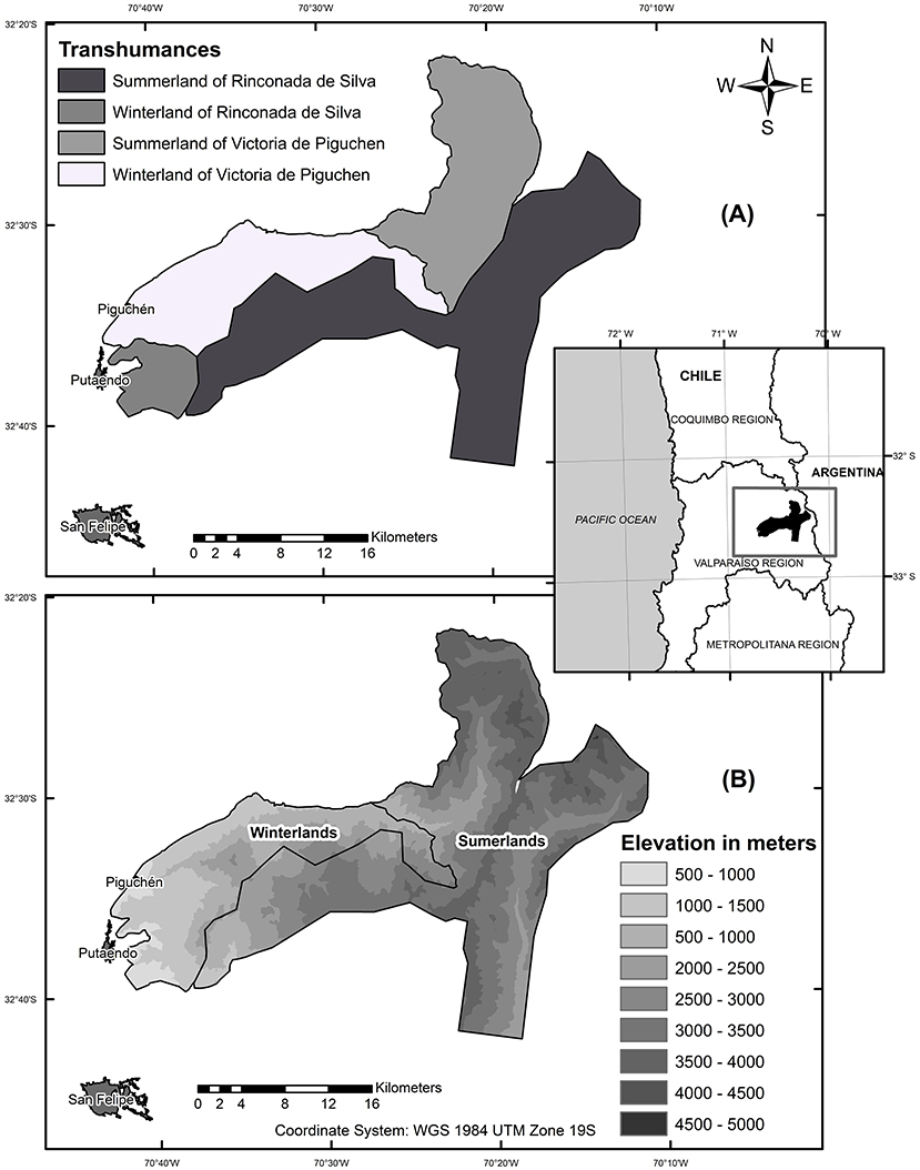
Figure 1. The research site is located in Central Chile. (A) Represents the total area for transhumance activity. For each agropastoralist community. With their respective Summerland and Winterland. (B) Represents the elevation (MASL) of the research site for Summerland and Winterland.
We reached two agropastoralists' associations of the Aconcagua Valley, one from the Piguchen village (we will refer to them as the Piguchén association) (−70°41′O −32° 34′ S) and the other from Putaendo (we will refer to them as the Rinconada de Silva association) (−70° 71′O −32° 62′ S). There were 51 members (90% men) in the Piguchen association and 43 (100% men) in the Putaendo Association in 2020. Both associations work with livestock, and their primary pasturing system is seasonal exploitation of the grasslands: transhumance. The agropastoralists divided the grazing areas into two: (Figure 1). (1) Summerland (“veranada”): high mountain pasture areas used in the austral summertime (December to April), when moisture is optimal for forage growth. Summerlands are primarily managed and used by privates (i.e., local communities and mining companies). These grazing areas exhibit unique biodiversity value and are of particular concern to conservation biologists and conservation institutions. Summerlands also provide habitat and connectivity to relevant fauna species, including apex predators, puma (Puma concolor), and wild herbivores, such as guanaco (Lama guanicoe) (Figure 3). Their primary fertile spots are the “vegas,” a type of high-mountain wetlands commonly found in the central Andes. They exhibit forage production, nourished by underground streams. They are strongholds of unique biodiversity, and they play a critical part in transhumance (Squeo et al., 2006). (2) Winterland (“invernada”) (May to December): a lowland grazing area for keeping the animals safe during austral wintertime. These sites are relatively well-connected to urban areas. Their vegetation is primarily bushes such as Vachellia caven, Mediterranean grasslands, and native trees. A lack of snowfall allows livestock to stay in the Winterlands over the autumn, winter, and part of the spring.
Agropastoralists keep the livestock in the Winterland from the beginning of autumn until late springtime (whereas Summerland is under extreme weather conditions). Then they move the animals back to the Summerlands, where temperatures and moistures spring belated forage production. This way, the transhumant system gets an extended grazing season for the livestock (Figure 3). In this activity, conflicts between agropastoralists and wildlife have intensified and become a significant threat in the last decade in central Chile (2010–2020). Possible causes are drastic climate change, the Mega-drought (explained above) (Vargas et al., 2021), urbanization, and land-use changes (Bonacic et al., 2007; Rodríguez et al., 2019).
Over the last years, urban and peri-urban inhabitants have increased the number of puma sighting reports to the public services (Bonacic et al., 2007; Sepúlveda et al., 2016). These agropastoralists link the puma-livestock problem with the hunter-prey interaction between these two groups. Nevertheless, it has been described that free-ranging dogs are a significant threat to livestock production and wildlife (Muñoz and Muñoz-Santibañez, 2016). Most studies addressing human-wildlife conflicts refer to carnivores and livestock predation conflicts (Ohrens et al., 2016; Rodríguez et al., 2019). However, conflicts with the Andean condor (Vultur gryphus) (a large scavenger bird) and the guanaco (Lama guanicoe) (a wild herbivore) (Vargas et al., 2021) have drawn more attention recently. The Andean condor supposedly performs attacks on newborn calves during the birth season in the high mountain. Still, this fact would require more scientific observation to be confirmed. However, puma and condor impact on livestock production seems to go back several years. In both cases, agropastoralists blamed the wild species for the economic losses. These wild species are often hated and considered pests (retaliation measures have been documented, mainly for puma). The conflict describes an increase in these wild species' populations, thus competing with livestock, primarily cattle, for the available forage. Recent research shows how guanaco's conflict range is expanding through the whole Andes Mountain area of the Valparaiso region. Historically, this wild herbivore inhabits mountainous areas. Since pre-Columbian times, guanaco was used for its meat and leather. It also had cultural and mythological relevance for Andean Indigenous communities (Garrido, 2010).
The local institutions in charge of farmers' issues are the Agricultural and Livestock Development Institute of the Ministry of Agriculture (INDAP) and Servicio Agrícola y Ganadero (in livestock and agriculture, SAG). The latter is also the only institution that addresses conflicts with wildlife. The SAG receives wildlife-livestock attacks or predation reports and proceeds from identifying the wildlife species. However, many attacks occur in the high mountains, far away from urban areas, so the authorities often miss them.
Workshops Methodology
We conducted two workshops in January and October 2020 with two different agropastoralist associations: Rinconada de Silva (Putaendo) and Piguchen (Figure 2). The workshops were spaced seven months apart due to the SARS-CoV-2 (COVID-19) pandemics. First, we contacted the community leaders to explain the methodology and its objectives. They agreed that the method was in their best interest, so we decided to conduct one meeting with each community (to carry out the workshops). The communities are hierarchical, so any group calling for meetings must be extended through the leaders. In 3 years working on this site, we confirm that making a community invitation is valid and sufficient to achieve a significant quorum (n = 84/94), Rinconada de Silva (n = 43), and Piguchen (n = 41). The participants did not provide their ages.
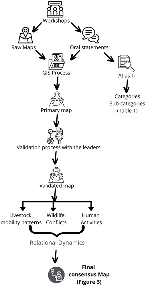
Figure 2. Process diagram for obtaining a final consensus map from participatory mapping workshops.
We applied participatory community methodologies as tools for collecting information regarding natural resources and local perceptions within a shared territory (Newing et al., 2011) and attending to the land's local production and environmental aspects. In Figure 2, we explain the process for collecting information and analysis. Through participatory mapping in each workshop, we collected the following data: (1) mapping on natural resources or essential elements for the territory (raw map, in Figure 2): (2) evaluation matrix on the land and the natural resources use. In the evaluation matrix, we asked them to assign a score from 1 to 5 for temperatures and rainfall from the present time and 20 years ago. Finally, we asked them to declare “20 years from now scenario,” exhibiting an “ideal future scenario”: how much precipitation and temperature are optimal for their livestock production. We used the evaluation matrix to evaluate the perception of significant changes in environmental variables for their productive activity (Geilfus, 2002). The variables were: (1) temperatures, (2) rainfall/snowfall, (3) how these changes have affected the livestock activity in the last 20 years, and (4) how they relate these changes with wildlife. Agropastoralists mapped these variables based on maximum and minimum thresholds for rainfall and temperatures. The maximum threshold was the most significant rainfall and temperature they remember. In contrast, the minimum threshold was the least rainfall and temperatures they could remember. With that settled, they draw many raindrops and “T” accordingly (Table 2). Agropastoralists explained the variable (3) and (4) in oral statements at the workshop (Figure 2).
These workshops aimed to broaden our knowledge of how human-wildlife conflicts originate. Participatory mapping assesses the community's Local Spatial Knowledge (LSK); it gathers spatial information to represent the reality of an organization or group of people (McCall, 2021). Participatory mapping of natural resources builds a visual representation of land use and natural resources perception. IFAD (2009) defined this methodology as information gathering made by the community in an open process, representing their real needs. This methodology attempts to gather information about a specific territory and its valorization by the community and then use it as a driver for decision-making and identify and locate the conflicts in such use.
The participants were randomized and divided into four groups of 4–7 people. We randomized the participants to deal with the communities hierarchy. By randomizing the participants, the leaders could fall into any group (we did not consider it socially appropriate to ask them not to participate). We did it this way to minimize the bias and have data representing reality beyond the leader's views (solely). Each group designated a group leader. We had a general facilitator and two supporting facilitators per workshop. We did this to ensure each group had a homogeneous dialogue, avoiding one-sided opinions and views (e.g., from the leaders). Each group was provided with materials and told to draw a map representing their territory as they perceived it, focusing on the winter and summer land use. We asked them to include three elements into the map: (1) natural and human components of the landscape (e.g., rivers, roads, forests, croplands), (2) areas with direct conflict with wildlife (puma, condor, and guanaco), and (3) areas with active use for grazing (Important for livestock activities). At the end of the given time, each group briefly exposed the results they obtained (oral statements). We documented the whole process by taking notes and photographing. At the end of each workshop, two sources of information were obtained that complemented each other: raw maps and oral statements. The oral statements provided complementary information to the mapping process: (1) attributes data, (2) non-spatial data, where otherwise [besides the oral statement] would not have been possible to have mapped. The low literacy level and the rural educational context make graphical representation challenging. Therefore, raw maps and oral statements are complementary and necessary to understand the productive system comprehensively.
Data Processing and Analysis
Consensus Map and Categorization of Attributes
We integrated the raw maps of each association into a single map. Each raw map contributed different attributes to the primary map (attributes described in Table 1). In two steps, we georeferenced raw maps data in the Geographic Information System (GIS) platform. First, the information of raw maps was georeferenced and identified by site names associated with two relevant spaces (Winterland and Summerland). Second, we used group information to complement a new map (primary map) (one for each association). Then we validated the primary map with the leaders, obtaining a validated map. Then, the attributes were classified into three categories to get an accurate visual representation: (1) Human activities; (2) Wildlife presence and interactions sites (human-wildlife conflicts); (3) Livestock mobility patterns within agropastoralists territory. These attributes represent elements in constant interaction within a mountainous system. The outcome of the process diagram (Figure 2) is a final consensus map representing the perception of these attributes' relational dynamics. With this information built, we elaborated the map presented in Figure 3.
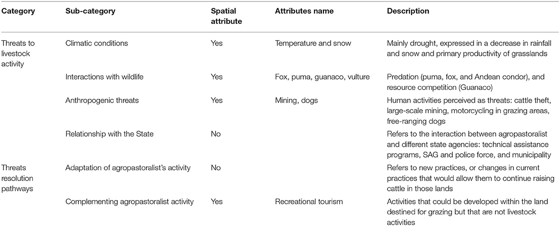
Table 1. Categories and sub-categories emerged from the workshop's response analysis.
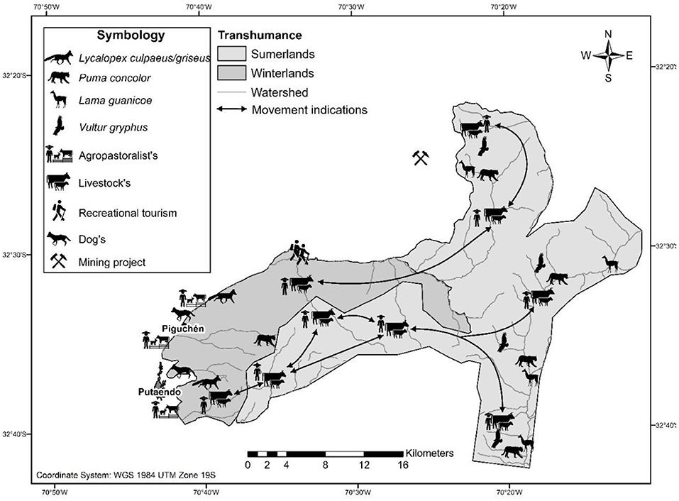
Figure 3. Final consensus map. It indicates the mobility patterns of the livestock and agropastoralists between Winterlands and Summerlands, localization of wildlife, and other human activities such as recreational tourism. In the Winterland, livestock interacts with wildlife such as Lycalopex culpaeus/griseus and human activities such as recreational tourism. In the Summerland, livestock interacts with wildlife such as the Puma concolor, Lama guanicoe, and Vulture gryphus.
Data Analysis
The notes of oral statements in Atlas.ti (2018) identify participants' explanations of the territory's use and threats, using Grounded Theory procedures (Strauss and Corbin, 1990). First, we reviewed the notes taken during each map explanation and compared them with the map's spatial information. After that first stage, we generated a set of categories we thought could group all responses. After discussing and editing the categories so they wouldn't overlap, we had a definitive set of six (6) categories and every response belonging to one of them. After that was accomplished, these six categories were grouped into two types: (1) Threats to livestock activity and (2) Threat resolution pathways. We chose this method due to the heterogeneity of the information obtained from the workshop. We systematized it to make it helpful in understanding Human-Wildlife Conflict. We identified the critical graphic features to put in the territory represented by icons, based on Burkhard and Maes (2017) recommendation for analyzing cartography. We conducted this process with each community and synthesized it as one map for the agropastoralist association.
Results
Results show the participation of 84 members from both associations, 43 from Rinconada de Silva (100% men) and 41 from Piguchen (97.5% men). Agropastoralists identified four key sub-categories for the 'threats to livestock activity and two categories as “threats resolution pathways” (Table 1). The following sections describe agropastoralist perceptions of each sub-category. Some of the raw maps are available in Supplementary Material.
Threats to Livestock Activity
Climatic Conditions
According to the agropastoralists, the shifting climatic conditions were the most relevant threat to livestock activity (Table 1). It directly affected livestock production because of the loss of primary productivity in grazing areas and water springs turning into swamps.
Both associations gave their perception of the rainfall and temperature shift from the past (20 years) to the present (2020) (Table 2). Drops and “T” represent Rainfall and Temperature, respectively, and the differences are proportional. The agropastoralists noted their perceptions within two thresholds: maximum rainfall ever recorded (the most significant number of drops in the table) and minimum rainfall ever recorded (the least number of drops), same for the temperature.
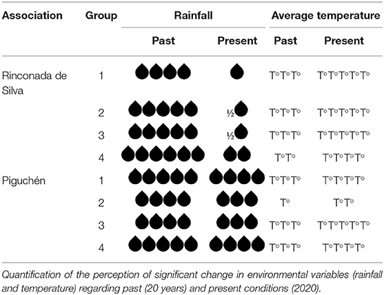
Table 2. Evaluation matrix.
All the groups agreed that rainfall significantly decreased in the past 20 years in both associations. Groups 2 and 3 from the Putaendo association declared a 90% rainfall decrease. Data for temperature shows that 100% of the associations' groups perceived that average temperatures have increased over the last decade. They marked the Summerland as the place where changes are most observable. They perceived temperature changes through two indicators: (1) A greater thermal amplitude between night and day, and (2) A reduction in the snowfall period and an apparent acceleration in the melting of the snowpack. In the spoken testimonies, agropastoralists from both associations declared hope for an increase in rainfall (ideal future scenario). Still, they think it will decrease in the next 20 years (future scenario). In the average temperature perceptions, each association group expects an increase in future average temperatures. Each group from both associations shows concern about climate change's adverse effects. Both associations said that Mega-drought is the primary current factor threatening their productive system.
Every year agropastoralists decide whether to take the animals toward the mountains. This decision depends on a previous evaluation of high grasslands. The evaluation criteria may vary depending on several factors, such as the geographical area, vegetation productivity, and personal considerations from the agropastoralists. They declared that it is unlikely to take the animals to the Summerland this year (2020) because the “risk is too high”.
Interactions With Wildlife
Both association groups pointed to the interactions with wildlife as a significant threat derived from the use of Summerlands. (1) Predation: they accuse predator attacks from puma to every livestock species they own (cows, sheep, goats, horses, and mules). Agropastoralists also declared that Andean condor performs attacks on cattle, especially on calves. As the agropastoralists described, Andean condor attacks occur when an individual or a group of condors separate and haunt a calf toward a cliff, causing it to fall and die, to then scavenge the remains. (2) Grass competition: the associations also declared an existing conflict for grass with the guanaco, especially in high-mountain areas (vegas). Agropastoralists said that the guanaco consumes “their property” (the grass) in the Summerland before they get to reach the same place with their animals. This situation would be affecting their animals' nutritional health. Both types of conflict, predation and grass competition, could be labeling the Summerlands as the most conflicting area. They also reported some minor damage performed by foxes, affecting only sheep and goats in Winterland. Parallelly, they have admitted that wildlife is a part of the mountain ecosystem, and they need to learn to live with it.
The association groups emphasize climate change and increased causality of wildlife conflict (especially with guanaco). Both groups declare that the decreasing of the snowpack clearly benefits the guanaco. They explain that high-mountain snowfall used to be more aggressive in previous years (10 years), thus controlling guanaco births, especially in wintertime. At the end of winter, the agropastoralists used to find frozen guanaco bodies in the high mountain. Recently they have not found any. This situation could reflect a climatic event promoting the guanaco's survival and possibly affecting its population. Puma and condor seem to have a more remote interaction with the agropastoralists. The latter explained that they perceive a stabilization in attacks performed by these two species. However, the livestock flow to the Summerland has decreased, increasing the proportional damage per predator attack. Every animal loss has a more significant impact on flock size.
Anthropogenic Threats
They also reported Mega-mining projects prospecting near the Summerland valleys as a threat to agropastoralists. Mega-mining, they said, represents a significant loss of space for pasture and disturbance of the natural environment. Another anthropic threat in both Summerlands and Winterlands is cattle raiding and free-roaming dogs. In addition, there have been reports of illegal drug activity in the Winterland area, which is declared as an emergent threat (currently not causing conflict). Finally, in the Winterland, unregulated activity such as motorbiking is reported as a severe threat to foraging availability since it erodes the already fragile hillsides and gullies. Regarding these threats, both associations are worried, but only the Piguchen association signaled to be directly affected by it.
Relationship With the State
The agropastoralists described the relationship with state institutions as a problem. The agropastoralists perceive treatment from the SAG and the police as unfair. They say that these institutions do not take sufficient actions when cattle raids or depredation (by puma) occur in the Summerlands. On the contrary, the associations declared that SAG often blames them for guanaco poaching accusations. Agropastoralists also described the technical assistance from public agencies as insufficient and irrelevant. These factors led to a feeling of abandonment from the state.
Threats Resolution Pathways
Adaptation
In the threat resolution pathways, the most relevant category was “measures to adapt their activity to the changing climatic scenario.” The most pertinent adaptation idea was changing the grazing management in Winterlands toward a more resilient one. Then, the resource can last longer and reduce the dependence on Summerlands. The associations stated that Summerland's grass production is progressively becoming less reliable, so they have to analyze every season whether or not to include it in the grazing program. Both associations declared their availability to collaborate in searching for productive alternatives to Winterland.
Supplementary Agropastoralist Activities
Results show that the Piguchen association would consider doing additional activities such as mountain and archaeological tourism as a possible way to diminish the threats they face. The particular characteristics of the territory make it potentially attractive for tourists. Piguchen association considers ecotourism in the high Andes as a possibility, particularly in the Summerland area. Two critical reasons reinforce this argument: (1) Ecotourism will complement the high Andes' agropastoralism (Only if the environmental conditions are stable) (2) Re-value the territory and the natural heritage.
The participatory mapping results reflect different perceptions among the participants on the importance of the territory, such as the natural borders in each grazing sector, access to specific sites, and the mining companies' relevance. However, 100% of the groups agreed that the Mega-drought was the primary driver threatening their production, increasing the conflict with wildlife. Thus, some groups declared different aspects for the “ideal future scenario” for the Aconcagua Valley. All the participants said, “Any future will only be possible if more rain (or water) comes.” Finally, they have considered the Summerland as an area of high risk due to multiple factors such as the conflict with various wild species. Considering the climate change scenario, they have decided to decrease the use of Summerland and improve the Winterland management planning to increase livestock productivity and reduce conflict with wildlife.
With the attributes presented in Figure 3, we built a summarized representation (Figure 4). We showed how the agropastoralists perceive the connection between wildlife interactions, significant changes in climatic variables, and other anthropogenic land uses. We stress the general perception that the livestock rearing activity is currently affected by external factors (e.g., climate, grassland production, interaction with wildlife). The current Mega-drought scenario led to a perception that the traditional agropastoralist activity is in crisis and needs external aid.
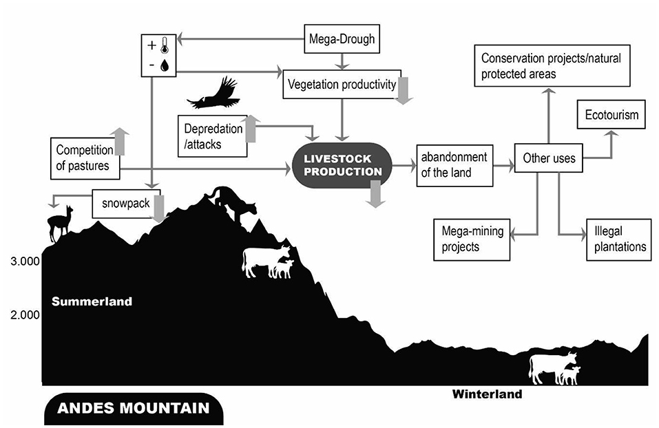
Figure 4. Visual representation of agropastoralists' perception of their territory (drawn from the workshops), divided into Winterland and Summerland. The image reflects a complex scenario, with multiple potential interconnections among elements, ultimately affecting livestock production: (1) Interactions between livestock and wildlife in the Summerland result in competition for pastures or depredation and attacks, depleting livestock production. (2) High temperatures and less rainfall led to the snowpack's thawing and decreased vegetation productivity, potentially intensifying competition for pastures. (3) Less livestock production results in more agropastoralists leaving the territory, thus allowing other activities to take over, seizing the unattended land.
Discussion
In this study, we identified prioritized areas to mitigate conflict with wildlife. To achieve this goal, we build a participatory mapping with local communities. Summerlands areas were identified as critical areas to reduce human-wildlife conflicts in the study area.
Our study reveals the local livestock-wildlife conflict as one part of a much more significant climate crisis. Our study provides information about current challenges faced by transhumant livestock activity and its impact on the interaction with wildlife. We summarize the main aspects of agropastoralist perceptions about territory, interactions with wildlife, and climate changes associated with the Mega-drought scenario (Figure 4).
Climatic Conditions
Our findings showed that agropastoralists have already perceived climatic changes in the mountains of Aconcagua Valley. Consistent with Roco et al. (2015), agropastoralist recognize a change in temperature and precipitation in the recent past. However, our study it's the first to show perceptions of climate changes in the mountains of Central Chile, while Roco et al. (2015) showed results with Family farm agriculture (FFA) in valleys of central Chile. These kinds of agriculture don't use the high mountains for pasture. Studies from other mountainous areas show similar findings (Batumike et al., 2021) regarding increasing temperature and decreasing precipitation. These results are essential because scarce information has documented pastoralist perceptions about climates changes in mountainous areas, most of the studies focused on agricultural communities (Reyes-García et al., 2019; Batumike et al., 2021).
Table 2 also shows variation in perceptions among associations. This could be because of differences in the age composition of each group, resulting in different amounts of time spent experiencing the rangelands and, therefore, different perceptions of climatic variation, but further research would be needed to confirm this hypothesis. The variation in the final consensus map would not be expected since it compiles every element identified by each group within their shared territory.
Our results show that the ideal climatic scenario for both associations (100% of the participants) leads to more precipitation and a lower average temperature. However, they declare to be aware of how unlikely that future is. They think that rainfall will decrease and the temperatures will increase. In fact, climatic projections for the area are not promising. Aldunce et al. (2017) show that annual precipitation is unlikely to grow, and the Mega-drought is likely to continue. Hundred percent of the participants claim that they will continue with the transhumant activity for several reasons: tradition, economy, emotional attachment, reasons previously described by Razeto et al. (2007). These motivations could reflect a relationship between the agropastoralists, the transhumant activity, and the mountain environment, beyond merely the economic.
Like our study, in the north of the studied area, farmers' beliefs suggest that the Mega-drought and climate change are underlying factors contributing to the farmers-guanaco conflict (Vargas et al., 2021). The changing environmental conditions seem to expose livestock activity to greater vulnerability, affecting wild species' tolerance. Regarding the climatic conditions, the projections coincide with the farmer's arguments. Central Chile has been facing a rainfall decline during the last decades. Persistent drought showed a precipitation deficit of ~30% (Boisier et al., 2016). Recent studies highlight that drying and warming conditions are very likely to continue with substantial impacts on surface hydrology, vegetation productivity, and snowpack (projected to decrease by 35–45%) (Bozkurt et al., 2018). The projected changes could significantly impact local agropastoralists' socio-economic conditions and wildlife interactions. A recent study reveals that the current Mega-drought is the hardest in the last 600 years in Central Chile (Morales et al., 2020). It suggests that South America will experience more severe droughts (IPBES, 2019). Despite this, no studies reveal the impact of climate conditions changes in Central Chile's mountain biodiversity or the consequences (direct and indirect) in wildlife interactions with other activities.
Interaction With Wildlife
Our results show that wildlife affects agropastoralists throughout the year but in different areas. Most of the reported conflicts regard carnivores and scavengers. However, there was an increasing conflict with guanaco in the last years. Perceived triggers of conflicts with each species are different. The agropastoralists perceived an increase in the guanaco population, possibly leading to direct competition for fodder with the livestock.
Regarding the puma, the problem seems connected to another issue besides predation. There are fewer agropastoralists present in the mountain because of the drought. So, one single attack performed by a puma could seem proportionally more damaging (more puma livestock ratio).
Nevertheless, there is little scientific information on guanaco's population estimates: the current data is scarce and outdated, difficulting a decision-making process. Regarding carnivores and scavengers, agropastoralists also declare that although the puma's population has not risen, the attacks performed on livestock (especially small ruminants) have increased. Currently, some agropastoralists are no longer willing to use the Summerland because the economic damage is “too high” (near 70% of losses in some cases). Despite the yield consequences, they would prefer to keep the flock in the Winterland if they have mainly small-ruminants. We encourage more and new research that goes deeper into this matter. Future studies should address wildlife population shifts and their interaction with agropastoralists.
Based on agropastoralists' experiences, we identified Summerlands as a high-risk area for their practices. The primary drivers to this risk could be the problematic interactions with wildlife, other human activities, and the declining vegetation productivity due to the Mega-drought. The associations marked the Mega-drought as the primary driver of this degradation process. This reality seems compatible with recent findings that climate change intensifies human-wildlife conflict by exacerbating resource scarcity (Abrahms, 2021). Additionally, climate change reinforces the Mega-Drought (Garreaud et al., 2021). Based on agropastoralists' perceptions, our results follow other scientific results that the frequency and severity of human-wildlife conflict are rising, especially in Summerlands areas or more degraded areas (Nyhus, 2016; Hodgson et al., 2020).
Anthropogenic Threats
Besides the environmental changes, anthropogenic actions could harm transhumant agropastoralism. And these changes could affect the interaction with the wildlife species.
Recently in the valley, there was registered some external activity: (1) Mega-Mining projects at starting operations, (2) Cattle raiding and free-roaming dogs, (3) Reports of illegal drug activity in the mountain (near to Winterland area), and (4) reported recreational motorbiking activity. It would be necessary to monitor how these events unfold over time and interact with agropastoral activity and wildlife. Based on other studies, we tend to project that these activities could impact transhumant pastoralism and the environment as a whole.
Mega-mining projects and other extractive activities adversely affect ecosystems by destroying habitat, overexploiting, polluting, and creating species disbalance and disease (Carranza et al., 2020). The level of production defines Mega-mining projects. This concept particularly references a large-scale extractivist output carried out by multinational companies, which occupy large extensions of territory for their development (SONAMI, 2014; OLCA and CGCGA, 2016). Mega-mining projects effects directly impact the transhumant agropastoralist activity.
As we have seen in previous sections, transhumant agropastoralism relies on natural seasonal pastures. The mega-mining procedures would imply disturbing noises, the creation of bare soil, and pollution of the water sources (Mensah et al., 2015). Some of these impacts could be irreversible. The destruction of aggregated soil (already weakened by climatic conditions) would imply a significant shift in soil structure, depleting grass production and increasing erosion. These changes will also negatively affect the ecosystemic processes such as the water cycle, the mineral cycle, the community dynamics, and the energy flow (Savory and Butterfield, 2017).
Another threat to agropastoralists is cattle raiding and the presence of free-roaming dogs. Free-roaming dogs perform attacks on livestock, potentially causing significant animal losses, spreading diseases (zoonotic and interspecies), causing relevant disturbances to wildlife, and competing with endemic species (Young et al., 2011). It is critical to conduct further collective methodologies, with a participatory approach to put all stakeholders in the common ground to take action and prevent this particular threat from growing.
The presence of illegal drug activity in the mountain area (Winterland) represents a significant future threat. Illicit markets are complex, but drug trafficking is often linked to other activities, such as wildlife trafficking (Van Uhm et al., 2021). The Aconcagua Valley would be an ideal scenario. The mere presence of illegal drug activity suggests that a further abandonment of the mountain by agropastoralists could leave a 'free space' for conducting illicit activities.
Recreational motorcycle activity looms as a significant threat, with scalable negative consequences. The repeated wheel traction causes significant erosion in already fragile land (causing productivity loss). Vehicle-wildlife interactions are proven to generate Roadkill, a term given to a dead animal struck by a vehicle. This phenomenon could significantly affect wildlife populations (Chen et al., 2021). We suggest collective action to enhance local education.
Relationship With the State
The agropastoralists declare a complex relationship with State institutions, pointing them as irrelevant when dealing with the livestock-wildlife conflict. State institutions hypothetically could argue that the livestock-wildlife conflict is an emerging issue, so classified as an unusual activity (out of their routine duties). However, the agropastoralists noted that even for the routine duties, state institutions are ineffective.
The involvement of stakeholders (including the State institutions) is vital for a conflict to be correctly addressed or for a participatory approach to be successful (Hargreaves et al., 2021; Spratt et al., 2021). In this regard, it would be necessary to fully address the agropastoralist-state relationship issues. The state and agropastoralists have an unequal power relation, and the latter feel abandoned by the state. They claim the state should prioritize the conflict and offer some “resolution paths.” The alleged lack of awareness by the state could lead to several scenarios: (1) intensifying the conflict, (2) retaliation actions. Collaboration between agropastoralists and other stakeholders (e.g., other communities, NGOs) could strengthen communication channels with the State (Coria and Calfucura, 2012).
Considering that the agropastoralists' perception exhibits only one side of the conflict, it is imperative to address a broader perspective with all the stakeholders to broaden our knowledge of the community's willingness to achieve a coexistence scenario (Akpo et al., 2015). A complete view will also accelerate the adoption of future territory planning (Spratt et al., 2021).
Adaptation
With our results, we suggest that the Winterlands' adaptation is the main pathway to address the threats agropastoralists face in their activity. This could be done through changes in current practices or including new methods in their activity to continue raising cattle in those lands. Since the association agreed on looking for alternative management, few workshops have been conducted to date (with few people due to the COVID-19 pandemic). However, these meetings have presented promising preliminary results. Due to the current state of degradation of the Winterland, we have concluded that adaptation to climate change should start by restoring this agroecosystem, at least partially (Del Valle et al., 2021). It is imperativeto initiate a participatory ecological restoration program in the Winterlands, so the recent livestock management shifts into one that will enhance the Winterland's resilience, improve productivity, and build adaptation to droughts. To do so, it is necessary to take elements from diverse disciplines, such as Ecological Grazing Management, Agroecology, and Ecological Restoration (Guzmán Luna et al., 2019). An interdisciplinary work can diminish grazing pressure over the Summerland, which has become a place of high vulnerability due to the uncertainty about climate and forage (a consequence of climate shifts or competition for forage). This has exposed agropastoralists to significant animal losses (predation, abrupt changes in the weather, raids).
Agropastoralists are currently evaluating whether to use Summerlands or not, ever again. This scenario sets an opportunity for the conservation of wildlife in these spaces. However, this opportunity must consider restoring and adapting the livestock production to less susceptible areas, such as Winterland. The future of large native species such as the condor, the puma, or the guanaco (which require large amounts of habitat), depends on the ability to conceive a well-planned human-wildlife program.
Contrastingly, the primary adaptation-to-climate-change actions proposed by the government focus on facilitating access to credit for private investment for adaptation. In the specific case of dairy goats, advance toward complete stabling, subsidizing feed purchasing. There is no other action exact for livestock production in the National nor Agricultural Climate Change Action Plan (Ministerio de Agricultura, 2013; Ministerio del Medio Ambiente, 2017). Therefore, these actions do not match the local proposals collected in the workshops. Agropastoralists have not been consulted in any previous process of public policymaking.
Nevertheless, this neglect is widely known. As FAO states in its most recent study about agropastoralism strategies, governments often lack knowledge of integrated landscape management (Wane et al., 2020). Also, evidence suggests that every successful government policy enhancing local adaptation must address the agropastoralists' heterogeneity (Cuni-Sanchez et al., 2018). Decisions should emerge from positive linkages between local communities' knowledge and organization and higher-level institutions (Fu et al., 2012).
Supplementary Agropastoralist Activities
Results show that agropastoralists have significant knowledge of the mountain and its biodiversity. Thus, Razeto et al. (2019) define the agropastoralists (or Arrieros) as guardians of the territory. “As they live in it, they will take care of it.” They also show that the Piguchen association would consider doing other mountain and archaeological tourism activities. This association declares that ecotourism could be a “resolution path,” positively affecting family economy and tradition. Furthermore, it would allow the agropastoralists to improve their financial status while maintaining their way of life). Although it does not address the effects of the Mega-drought and the derived conflicts, ecotourism looms as a feasible possibility to face the financial urgency.
Lee and Jan (2019) define ecotourism as traveling to less exploited natural places to see the natural setting and wildlife and enjoy culture while conserving the site's environment. Some elements of that definition could be acquired for further discussion. On the one hand, ecotourism could help agropastoralists adequately protect the land (by providing financial revenue and increasing their presence in the mountain). Also, this activity could provide environmental education for a broader audience. In contrast, some risks in this activity could be public exposure, which could bring negative externalities, such as contamination and over-visit of fragile, sensitive areas (Collins, 1999, quoted by Khanra et al., 2021). Additionally, a complete turn from agropastoralism to tourism as their primary economic activity would make them dependent on tourism market oscillations. Suppose the tourism market drops as it did with the SarsCoV-19 (COVID-19) pandemics. In that case, it could constraint their livelihoods even more, so several parameters should be taken into account to determine whether or not it is profitable and ecologically relevant.
Results of the participatory mapping show that the agropastoralists own significant knowledge of the mountain (and its biodiversity). Thus, Razeto et al. (2019) define the agropastoralists (or Arrieros) as guardians of the territory. “As they live in it, they will take care of it”.
Final Considerations
In summary, this study represents a contribution to human-wildlife studies because we put into value local knowledge and local perceptions to build territorial planning in the context of Human-Wildlife conflicts. We also value local perceptions about climate change impacts in the context of Megadrought (García-del-Amo et al., 2020; Batumike et al., 2021). Agropastoralism in Central Chile seems to be an activity where the agropastoralists do not constantly stay with the livestock. A lack of management can contribute to a greater risk of losing animals (raids, attacks by carnivores, etc.). Better management practices, planning, and livestock can reduce losses and increase agropastoralists' productivity. Our participatory mapping set up a reflection space for agropastoralists. They account for the current challenges of the activity and open space for coexistence. Participatory mapping can be understood as a “situation assessment,” informing and guiding decision-making, particularly challenging study areas. This mapping allows us to prioritize places to start working and possibly take action. Notably, this case shows us how the Summerlands are highly challenging areas due to three main reasons: (1) mitigating conflicts with wildlife (2) they present uncontrolled anthropic intervention, such as livestock raids and mining (3) there are areas of significant climatic uncertainty. Results reflect an uncertain future for coexistence in this particular research site. The chronological analysis shows us how the agropastoralists projected their activity. And what the wildlife's role in the system is. Simultaneously, this methodology creates a space for ongoing reflection and debate on the activity's current productive and ecological issues. Agropastoralists' testimonies reflect that this reflection space is innovative for the area: they do not recall a similar previous process. Historically there have been few stakeholders, through non-socialized public policies, driving all the decision-making in agropastoralism at the research site. This situation could have led to a non-participatory approach to the site's issues so far, resulting in a persisting (and growing) human-wildlife conflict.
The current scenario shows a probable increase in livestock and wildlife interaction, a shifting climate, and an increase in agropastoralism vulnerability. Additional multisectoral actions will be required to prioritize the area's activity and adapt it to the future scenario. Future research is needed to increase resilience, reduce vulnerability and adapt the mountain agropastoralist sector. This study also confirms that complex socio-economic, political, and environmental factors (and their interaction) drive negative human-wildlife reciprocity. Previous studies reveal the need to adopt holistic management for multi-species conservation conflicts (Pozo et al., 2020). The consequences have been (and will be) severe, especially in the agriculture sector and biodiversity. Territory threats represent a significant driver to the intensifying of the conflicts. Future initiatives in the area will only be possible if the state works with local communities and scientists to develop public policies that promote biodiversity rehabilitation.
Data Availability Statement
The datasets presented in this article are not readily available because the studied group authorized us to publish only two raw maps (available in supplementary materials). We are not providing the complete set of raw maps in supplementary materials since they might have sensitive information regarding the community's privacy and the socio-environmental conflict with the mining company. Requests to access the datasets should be directed to SV, c29sYW5nZXZhcmdhc0BnbWFpbC5jb20=.
Ethics Statement
Ethical review and approval was not required for the study on human participants in accordance with the local legislation and institutional requirements. The patients/participants provided their written informed consent to participate in this study.
Author Contributions
SV, MH, and JD: study design and data collection. SV, MH, JD, and AH: analysis. All authors: writings and revision. All authors contributed to the article and approved the submitted version.
Conflict of Interest
The authors declare that the research was conducted in the absence of any commercial or financial relationships that could be construed as a potential conflict of interest.
Publisher's Note
All claims expressed in this article are solely those of the authors and do not necessarily represent those of their affiliated organizations, or those of the publisher, the editors and the reviewers. Any product that may be evaluated in this article, or claim that may be made by its manufacturer, is not guaranteed or endorsed by the publisher.
Acknowledgments
This research results from a collaboration with the agropastoralism association of Piguchen and Putaendo, from Putaendo Valley, in the Region of Valparaiso. We sincerely thank them for opening their homes and showing us their daily struggle with the Mega drought. We also thank Bárbara Palma, Ismael Berwart, and Arón Cadiz for their support in the fieldwork. We thank the Yastay Foundation team, which helped in various ways along this process. We thank Jean Francois Casale for his revisions to the article.
Supplementary Material
The Supplementary Material for this article can be found online at: https://www.frontiersin.org/articles/10.3389/fcosc.2022.731382/full#supplementary-material
References
Abrahms, B (2021). Human-wildlife conflict under climate change. Science 373, 6554. doi: 10.1126/science.abj4216
Akpo, E., Crane, T. A., Vissoh, P. V., and Tossou, R. C. (2015). Co-production of knowledge in multi-stakeholder processes: analyzing joint experimentation as social learning. J. Agric. Educ. Extens. 21, 4. doi: 10.1080/1389224X.2014.939201
Aldunce, P., Araya, D., Sapiain, R., Ramos, I., Lillo, G., Urquiza, A., et al. (2017). Local perception of drought impacts in a changing climate: the mega-drought in Central Chile. Sustainability 9, 2053. doi: 10.3390/su9112053
Atlas.ti (2018). Scientific Software Development GmbH. Qualitative Data Analysis. Version 8.0. Berlin.
Badola, R., Ahmed, T., Gill, A. K., Dobriyal, P., Das, G. C., Badola, S., et al. (2021). An incentive-based mitigation strategy to encourage coexistence of large mammals and humans along the foothills of Indian Western Himalayas. Nat. Sci. Rep. 11, 5235. doi: 10.1038/s41598-021-84119-7
Bambach, N., Meza, F. J., Gilabert, H., and Miranda, M. (2019). Impacts of climate change on the distribution of species and communities in the Chilean Mediterranean ecosystem. Reg. Environ. Change 13, 1245–1257. doi: 10.1007/s10113-013-0425-7
Basupi, L. V., Quinn, C. H., and Dougill, A. J. (2017). Using participatory mapping and a participatory geographic information system in pastoral land use investigation: impacts of rangeland policy in Botswana. Land Use Policy 64, 363–373. doi: 10.1016/j.landusepol.2017.03.007
Batumike, R., Bulonvu, F., Imani, G., Akonkwa, D., Gahigi, A., Klein, A. J., et al. (2021). Climate change and hunter-gatherers in montane eastern DR Congo. Clim. Dev. 2021, 1–12. doi: 10.1080/17565529.2021.1930987
Boisier, J. P., Alvarez-Garreton, C., Cordero, R. R., Damiani, A., Gallardo, L., Garreaud, R. D., et al. (2018). Anthropogenic drying in central-southern Chile evidenced by long-term observations and climate model simulations. Elementa Sci. Anthropocene 6, 74. doi: 10.1525/elementa.328
Boisier, J. P., Rondanelli, R., Garreaud, R. D., and Muñoz, F. (2016). Anthropogenic and natural contributions to the Southeast Pacific precipitation decline and recent Mega-drought in central Chile. Geophys. Res. Lett. 43, 413–421. doi: 10.1002/2015GL067265
Bonacic, C., Gálvez, N., Ibarra, J., Amar, M., Sanhueza, D., Murphy, T., et al (2007). Informe técnico final proyecto “Evaluación del conflicto entre carnívoros silvestres y ganadería”. Santiago, Chile: Servicio Agrícola y Ganadero. Available online at: http://www.sag.cl/sites/default/files/INFORME%2520FINAL%2520PROYECTO2.pdf.
Bozkurt, D., Rondanelli, R., Marín, J. C., and Garreaud, R. (2018). Foehn event triggered by an atmospheric river underlies record-setting temperature along continental Antarctica. J. Geophys. Res. Atmos. 123, 3871–3892. doi: 10.1002/2017JD027796
Brown, J. R., Kluck, D., McNutt, C., and Hayes, M. (2016). Assessing Drought Vulnerability Using a Socio-ecological Framework. Soc. Range Manag. 38, 162–168. doi: 10.1016/j.rala.2016.06.007
Burkhard, B., and Maes, J. (2017). Mapping Ecosystem Services. Sofia: Pensoft Publishers. doi: 10.3897/ab.e12837
Cappa, F., Bani, L., and Meriggi, A. (2021). Factors affecting the crop damage by wild boar (Sus scrofa) and effects of population control in the Ticino and Lake Maggiore Park (North-western Italy). Mamm. Biol. 101, 451–463. doi: 10.1007/s42991-021-00125-2
Carranza, D. M., Varas-Belemmi, K., De Veer, D., Iglesias-Müller, C., Coral-Santacruz, D., Méndez, F. A., et al. (2020). Socio-environmental conflicts: an underestimated threat to biodiversity conservation in Chile. Enviro. Sci. Policy 110, 46–59. doi: 10.1016/j.envsci.2020.04.006
Cerda, J. C (2016). “El Territorio. Una Visión Física de Aconcagua,” in Aconcagua, la comarca, eds A. Canales, M. Canales, and J. Razeto (San Felipe, Chile: Ediciones Almendral), 12–38.
Chen, T., Kuo, S., and Lee, J. (2021). Patterns in motorcycle-related Roadkill on a resort island. Ocean Coastal Manag. 201, 105489. doi: 10.1016/j.ocecoaman.2020.105489
Collins, A (1999). Tourism development and natural capital. Ann. Tourism Res. 26, 98–109. doi: 10.1016/S0160-7383(98)00059-0
Coria, J., and Calfucura, E. (2012). Ecotourism and the development of indigenous communities: the good, the bad and the ugly. Ecol. Econ. 73, 47–55. doi: 10.1016/j.ecolecon.2011.10.024
Cowling, R. M., Potts, A. J., Bradshaw, P. L., Colville, J., Arianoutsou, M., Ferrier, S., et al. (2014). Variation in plant diversity in Mediterranean-climate ecosystems: the role of climatic and topographical stability. J. Biogeogr. 42, 3. doi: 10.1111/jbi.12429
Cowling, R. M., Rundel, P. W., Lamont, B. B., Kalin Arroyo, M., and Arianoutsou, M. (1996). Plant diversity in mediterranean-climate regions. Trends Ecol. Evol. 11, 362–366. doi: 10.1016/0169-5347(96)10044-6
CR2 (2015). Informe a la nación: La megasequía 2010-2015, una lección para el futuro. Santiago, Chile: Centro de Ciencia del Clima y la Resiliencia (CR)2.
Cuni-Sanchez, A., Omeny, P., Pfeifer, M., Olaka, L., Boru, M., Marchant, R., et al. (2018). Climate change and pastoralists: perceptions and adaptation in montane Kenya. Clim. Dev. 11, 1–12. doi: 10.1080/17565529.2018.1454880
Del Valle, J. P., Hargreaves, M., Vargas, S., and Domingo, F. (2021). Estrategias para la adaptación al cambio climático de agroecosistemas ganaderos (presentación congreso). 2do Congreso Chileno de Agroecología, La Serena, Chile. doi: 10.13140/RG.2.2.26043.95520
Dong, S., Kassam, K. S., Tourrand, J. F., and Boone, R. B. (2016). Building Resilience of Human-Natural Systems of Pastoralism in the Developing World. Interdisciplinary Perspectives. Cham, Switzerland: Springer Nature. doi: 10.1007/978-3-319-30732-9
Fu, Y., Grumbine, R. E., Wilkes, A., Wang, Y., Xu, J. C., and Yang, Y. P. (2012). Climate change adaptation among tibetan pastoralists: challenges in enhancing local adaptation through policy support. Environ. Manag. 50, 607–621. doi: 10.1007/s00267-012-9918-2
García-del-Amo, D., Mortyn, P. G., and Reyes-García, V. (2020). Including indigenous and local knowledge in climate research: an assessment of the opinion of Spanish climate change researchers. Climatic Change 160, 67–88. doi: 10.1007/s10584-019-02628-x
Garreaud, R. D., Alvarez-Garreton, C., Barichivich, J., Boisier, J. P., Christie, D., Galleguillos, M., et al. (2017). The 2010–2015 Mega-drought in central Chile: impacts on regional hydroclimate and vegetation. Hydrol. Earth Syst. Sci. 21, 6307–6327. doi: 10.5194/hess-21-6307-2017
Garreaud, R. D., Clem, K., and Vicencio Veloso, J. (2021). The South Pacific pressure trend dipole and the southern blob. J. Clim. 34, 18. doi: 10.1175/JCLI-D-20-0886.1
Garrido, F (2010). “La importancia de los camélidos en el mundo indígena y prehispánico nacional,” in Plan Nacional de Conservación del Guanaco (Lama guanicoe) en Chile 2010-2015, ed M. P. Grimberg (Atacama, Chile: Corporación Nacional Forestal), 25–26.
Geilfus, F (2002). 80 Herramientas para el Desarrollo Participativo. Diagnóstico, Planificación, Monitoreo y Evaluación. San José, Costa Rica: Instituto Interamericano de Cooperación para la Agricultura (IICA).
Guzmán Luna, A., Ferguson, B. G., Giraldo, O., Schmook, B., and Aldasoro Maya, E. M. (2019). Agroecology and restoration ecology: fertile ground for Mexican peasant territoriality? Agroecol. Sust. Food Syst. 43, 10. doi: 10.1080/21683565.2019.1624284
Hargreaves, M. J., Hargreaves, A., and Riveros, J. L. (2021). Perception and adoption of new agricultural technologies in a Northern Inland Mozambique. Afr. J. Agricult. Res. 17, 2. doi: 10.5897/AJAR2020.14899
Hernández, A., Miranda, M., Arellano, E. C., Saura, S., and Ovalle, C. (2015). Landscape dynamics and their effect on the functional connectivity of a Mediterranean landscape in Chile. Ecol. Indicat. 48, 198–206. doi: 10.1016/j.ecolind.2014.08.010
Hodgson, D., McDonald, J., and Hosken, D. (2015). What do you mean, 'resilient'? Trends Ecol. Evol. 3, 503–506. doi: 10.1016/j.tree.2015.06.010
Hodgson, I. D., Redpath, S. M., Sandstrom, C., and Biggs, D. (2020). The State of Knowledge and Practice on Human Wildlife Conflicts. Gland: Luc Hoffmann Institute.
IFAD (2009). Good Practices in Participatory Mapping. Uttar Pradesh, India: International Fund for Agricultural Development.
IPBES (2019). Summary for Policymakers of the Global Assessment Report on Biodiversity and Ecosystem Services. Bonn, Germany: Intergovernmental Science-Policy Platform on Biodiversity and Ecosystem Services.
IUCN (2020a). IUCNSSC Position Statement on the Management of Human-Wildlife Conflict. IUCN Species Survival Commission (SSC) Human-Wildlife Conflict Task Force. Available online at: www.iucn.org/theme/species/publications/policies-and-position-statements (accessed June 20, 2021).
IUCN (2020b). Whats is human-wildlife conflict? IUCN Species Survival Commission (SSC) Human-Wildlife Conflict Task Force. Available online at: https://www.iucn.org/theme/species/publications/policies-and-position-statements. (accessed March 1, 2021).
Karanth, K. K., Gopalaswamy, A. M., DeFries, R., and Ballal, N. (2012). Assessing patterns of human-wildlife conflicts and compensation around a central indian protected area. PLoS ONE 7, 12. doi: 10.1371/journal.pone.0050433
Khanra, S., Dhir, A., Kaur, P., and Mäntymäki, M. (2021). Bibliometric analysis and literature review of ecotourism: toward sustainable development. Tourism Manag. Perspect. 37, 100777. doi: 10.1016/j.tmp.2020.100777
Kolinski, L., and Milich, K. M. (2021). Human-wildlife conflict mitigation impacts community perceptions around Kibale National Park, Uganda. Diversity 13, 145. doi: 10.3390/d13040145
König, H. J., Carter, N., Ceau?u, S., Lamb, C., Ford, A. T., and Kiffner, C. (2021), Human–wildlife coexistence in science practice. Conserv. Sci. Pract. 3, e401. doi: 10.1111/csp2.401
König, H. J., Kiffner, C., Kramer-Schadt, S., Fürst, C., Keuling, O., and Ford, A. T. (2020). Human-wildlife coexistence in a changing world. Conserv. Biol. 34, 786–794. doi: 10.1111/cobi.13513
Lee, T. H., and Jan, F. (2019). Can community-based tourism contribute to sustainable development? Evidence from residents' perceptions of the sustainability. Tourism Manag. 70, 368–380. doi: 10.1016/j.tourman.2018.09.003
López, O (2019). Identificación de áreas con posible extracción ilegal de agua en la cuenca de Petorca, Chile, mediante la estimación de áreas agrícolas sin derechos de aprovechamiento de agua asignados (tesis de pregrado). Santiago de Chile: Universidad de Chile.
Marchant, C (2019). La práctica trashumante pehuenche en la Araucaní andina: una forma de construir y habitar los territorios de montaña del sur de Chile. Rev. Geografía Norte Grande 74, 187–206. doi: 10.4067/S0718-34022019000300187
Marchini, S., and Crawshaw, P. (2015). Human-wildlife conflicts in Brazil: a fast-growing issue. Hum. Dimens. Wildl. 20, 323–328. doi: 10.1080/10871209.2015.1004145
Margules, C., Boedhihartono, A. K., Langston, J. D., Riggs, R. A., Sari, D. A., Sarkar, S., et al. (2020). Transdisciplinary science for improved conservation outcomes. Environ. Conserv. 47, 4. doi: 10.1017/S0376892920000338
Marino, A., Ciucci, P., Redpath, S. M., Ricci, S., Young, J., and Salvatori, V. (2021). Broadening the toolset for stakeholder engagement to explore consensus over wolf management. J. Environ. Manag. 296, 113125. doi: 10.1016/j.jenvman.2021.113125
McCall, M. K (2021). Participatory mapping and PGIS: secerning facts and values, representation and representativity. Int. J. E Plann. Res. 10, 3. doi: 10.4018/IJEPR.20210701.oa7
Mensah, A. K., Mahiri, I. O., Owusu, O., Mireku, O. D., Wireko, I., and Kissi, E. A. (2015). Envrionmental impacts of mining: a study of mining communities in Ghana. Appl. Ecol. Environ. Sci. 3, 3. doi: 10.12691/aees-3-3-3
Ministerio de Agricultura (2013). Plan de Adaptación al Cambio Climático del Sector Silvoagropecuario. Propuesta Ministerial Elaborada en el marco del Plan de Acción Nacional de Cambio Climático 2008-2012. Santiago de Chile: Ministerio de Agricultura.
Ministerio del Medio Ambiente (2017). Plan de Acción Nacional de Cambio Climático 2017-2022. Santiago, Chile: División de Cambio Climático del Ministerio del Medio Ambiente, Gobierno de Chile.
Morales, M. S., Cook, E. R., Barichivich, J., Christie, D. A., Villalba, R., LeQuesne, C., et al. (2020). Six hundred years of South American tree rings reveal an increase in severe hydroclimatic events since mid-20th century. Proc. Natl. Acad. Sci. U. S. A. 117, 16816–16823. doi: 10.1073/pnas.2002411117
Muñoz, A. E., and Muñoz-Santibañez, P. (2016). Conflictos entre fauna silvestre y agricultura en Chile. Rev. Agron. Forest. UC 53, 10–17.
Myers, N., Mittermeier, R. A., Mittermeier, C. G., da Fonseca, G. A. B., and Kent, J. (2000). Biodiversity hotspots for conservation priorities. Nature 403, 853–858. doi: 10.1038/35002501
Naha, D., Dash, S. K., Kupferman, C., Beasley, J. C., and Sathyakumar, S. (2021). Movement behavior of a solitary large carnivore within a hotspot of human-wildlife conflicts in India. Sci. Rep. 11, 3862. doi: 10.1038/s41598-021-83262-5
Newing, H., Eagle, C., Puri, R. K., and Watson, C. W. (2011). Conducting Research in Conservation, a Social Science Perspective. Oxford: Routledge. doi: 10.4324/9780203846452
Nyhus, P. J (2016). Human–wildlife conflict and coexistence. Annu. Rev. Environ. Resour. 41, 1. doi: 10.1146/annurev-environ-110615-085634
Ohrens, O., Bonacic, C., and Treves, A. (2016). Non-lethal defense of livestock against predators: flashing lights deter puma attacks in Chile. Front. Ecol. Environ. 17, 32–38. doi: 10.1002/fee.1952
OLCA and CGCGA (2016). Dimensión socioambiental de los conflictos territoriales en Chile. Santiago, Chile: Observatorio Latinoamericano de Conflictos Ambientales – Colectivo de Geografía Crítica Gladys Armijo.
Palomo, I., Martín-López, B., López-Santiago, C., and Montes, C. (2011). Participatory scenario planning for protected areas management under the ecosystem services framework: the Doñana social-ecological system in Southwestern Spain. Ecol. Soc. 16, 23. doi: 10.5751/ES-03862-160123
Peterson, M. N., Birckhead, J. L., Leong, K., Peterson, M. J., and Peterson, T. R. (2010). Rearticulating the myth of human–wildlife conflict. Conserv. Lett. 3, 74–82. doi: 10.1111/j.1755-263X.2010.00099.x
Pozo, C., Galán-Martín, A., Reiner, D. M., Mac Dowell, N., and Guillén-Gosálbez, G. (2020). Equity in allocating carbon dioxide removal quotas. Nat. Clim. Change 10, 640–646. doi: 10.1038/s41558-020-0802-4
Puri, R. K (2011). “Participatory mapping,” in Conducting Research in Conservation, A Social Science Perspective, ed H. Newing (Oxford: Routledge), 187–197.
Raymond, C. M., Fagerholm, N., and Kyttä, M. (2020). Honouring the participatory mapping contributions and enduring legacy of Professor Gregory G. Brown. Appl. Geogr. 116, 102155. doi: 10.1016/j.apgeog.2020.102155
Razeto, J., Catalán, E., and Skewes, J. (2019). Soberanía territorial, conservación Ambiental y comunidades de campo común en Chile central. Polis Rev. Latinoamericana 54, 75–89. doi: 10.32735/S0718-6568/2019-N54-1403
Razeto, J., Pavlovic, D., Cornejo, A., Bustos, C., Madrid, A., Cerda, J. C., et al. (2007). Estudios de la Vida en las Montañas de Aconcagua. San Felipe, Chile: Ediciones Almendral.
Redpath, S. M., Young, J., Evely, A., Adams, W. M., Sutherland, W.J., et al. (2013). Understanding and managing conservation conflicts. Trends Ecol. Evol. 28, 2. doi: 10.1016/j.tree.2012.08.021
Reyers, B., Roux, D. J., Cowling, R. M., Ginsburg, A. E., Nel, J. L., and O'Farrell, P. (2010). Conservation planning as a transdisciplinary process. Conserv. Biol. 24, 4. doi: 10.1111/j.1523-1739.2010.01497.x
Reyes-García, V., García-del-Amo, D., Benyei, P., Fernández-Llamazares, A., Gravani, K., Junqueira, A. B., et al. (2019). A collaborative approach to bring insights from local observations of climate change impacts into global climate change research. Environ. Sust. 39, 1–8. doi: 10.1016/j.cosust.2019.04.007
Roco, L., Engler, A., Bravo-Ureta, B. E., and Jara-Rojas, R. (2015). Farmers' perception of climate change in mediterranean Chile. Reg. Environ. Change 15, 867–879. doi: 10.1007/s10113-014-0669-x
Rodríguez, V., Poo-Muñoz, D. A., Escobar, L. E., Astorga, F., and Medina-Vogel, G. (2019). Carnivore–livestock conflicts in Chile: evidence and methods for mitigation. Hum. Wildl. Interact. 13, 50–61.
Sahraoui, Y., De Godoy Leski, C., Benot, M. L., Revers, F., Salles, D., and van Halder, I. (2021). Integrating ecological networks modelling in a participatory approach for assessing impacts of planning scenarios on landscape connectivity. Landscape Urban Plann. 209, 104039. doi: 10.1016/j.landurbplan.2021.104039
Savory, A., and Butterfield, J. (2017). Holistic Management: A Commonsense Revolution to Restore Our Environment, 3rd Ed. Washington, DC: Island Press.
Senbeto Jiren, T., Riechers, M., Kansky, R., and Fischer, J. (2021). Participatory scenario planning to facilitate human-wildlife coexistence. Conserv. Biol. 35, 1957–1965. doi: 10.1111/cobi.13725
Sepúlveda, C., Pino, R., Donoso, D., and Iriarte, A. (2016). El Puma en la Región de Coquimbo: Develando su ecología e interacción con la ganadería. Santiago, Chile: Ediciones SAG Región de Coquimbo y Flora and Fauna.
Shanko, G., Tona, B., and Adare, B. (2021). Human-wildlife conflict around Belo-Bira Forest, Dawro Zone, Southwestern Ethiopia. Int. J. Ecol. 2021, 9944750. doi: 10.1155/2021/9944750
SONAMI (2014). Caracterización de la pequeña y mediana minería en Chile. Santiago, Chile: Gerencia de Investigación y Desarrollo, Sociedad Nacional de Minería.
Spratt, E., Jordan, J., Winsten, J., Huff, P., van Schaik, C., and Grimsbo Jewett, J. (2021). Accelerating regenerative grazing to tackle farm, environmental, and societal challenges in the upper Midwest. J. Soil Water Conserv. 76, 15A−23A. doi: 10.2489/jswc.2021.1209A
Squeo, F. A., Warner, B. G., Aravena, R., and Espinoza, D. (2006). Bofedales: high altitude peatlands of the central Andes. Rev. Chilena Historia Nat. 79, 245–255. doi: 10.4067/S0716-078X2006000200010
Strauss, A., and Corbin, J. (1990). Basics of Qualitative Research: Grounded Theory Procedures and Techniques. Thousand Oaks, CA: Sage.
Suryawanshi, K. R., Bhatnagar, Y. V., Redpath, S., and Mishra, C. (2013). People, predators and perceptions: patterns of livestock depredation by snow leopards and wolves. J. Appl. Ecol. 50, 550–560. doi: 10.1111/1365-2664.12061
Van Uhm, D., South, N., and Wyatt, T. (2021). Connections between trades and trafficking in wildlife and drugs. Trends Organ Crim. 24, 425–446. doi: 10.1007/s12117-021-09416-z
Vargas, S. P., Castro-Carrasco, P. J., Rust, N. A., and Riveros, J. L. (2021). Climate change contributing to conflicts between livestock farming and guanaco conservation in central Chile: a subjective theories approach. Oryx 55, 275–283. doi: 10.1017/S0030605319000838
Vicuña, S., Garreaud, R. D., and McPhee, J. (2010). Climate change impacts on the hydrology of a snowmelt driven basin in semi-arid Chile. Clim. Change 105, 469–488. doi: 10.1007/s10584-010-9888-4
Von Wehrden, H., Guimaraes, M. H., Bina, O., Varanda, M., Lang, D. J., and John, B. (2018). Interdisciplinary and transdisciplinary research: finding the common ground of multi-faceted concepts. Sust. Sci. 14, 875–888. doi: 10.1007/s11625-018-0594-x
Wane, A., Cesaro, J. D., Duteurtre, G., Touré, I., Ndiaye, A., Alary, V., et al. (2020). The economics of pastoralism in Argentina, Chad and Mongolia. Market participation and multiple livelihood strategies in a shock-prone environment. FAO Anim. Prod. Health 182:88. doi: 10.4060/cb1271en
Yitayih, Y., Ejigu, D., and Mola, M. (2021). Population size and human-grivet monkeys (Chlorocebus aethiops) conflict in Zegie peninsula, Bahir Dar, Ethiopia. BMC Zool. 6, 2. doi: 10.1186/s40850-021-00066-w
Young, J. K., Olson, K. A., Reading, R. P., Amgalanbaatar, S., and Berger, J. (2011). Is wildlife going to the dogs? Impacts of feral and free-roaming dogs on wildlife populations. Bioscience 6, 125–132. doi: 10.1525/bio.2011.61.2.7
Zimmermann, A., Johnson, P., de Barros, A. E., Inskip, C., Amit, R., Cuellar Soto, E., et al. (2021). Every case is different: cautionary insights about generalisations in human-wildlife conflict from a range-wide study of people and jaguars. Biol. Conserv. 260, 109185. doi: 10.1016/j.biocon.2021.109185
Keywords: Mega-drought, conservation conflict, perceptions, territory planning, coexistence
Citation: Vargas SP, Hargreaves M, Del Valle JP, Hodges A, Beltrami E, Toledo MF and Sapaj-Aguilera G (2022) Coexistence in Times of Climate Crisis: A Participatory Mapping to Understanding Conservation Conflicts in the Central Andes of Chile. Front. Conserv. Sci. 3:731382. doi: 10.3389/fcosc.2022.731382
Received: 27 June 2021; Accepted: 31 March 2022;
Published: 20 May 2022.
Edited by:
Silvio Marchini, University of São Paulo, BrazilReviewed by:
Francisco Lagos Susaeta, University of Cordoba, SpainDi Yang, University of Wyoming, United States
Patrick Roehrdanz, Conservation International, United States
Copyright © 2022 Vargas, Hargreaves, Del Valle, Hodges, Beltrami, Toledo and Sapaj-Aguilera. This is an open-access article distributed under the terms of the Creative Commons Attribution License (CC BY). The use, distribution or reproduction in other forums is permitted, provided the original author(s) and the copyright owner(s) are credited and that the original publication in this journal is cited, in accordance with accepted academic practice. No use, distribution or reproduction is permitted which does not comply with these terms.
*Correspondence: Solange P. Vargas, c3Zhcmdhc0B1c2VyZW5hLmNs
†These authors have contributed equally to this work