
94% of researchers rate our articles as excellent or good
Learn more about the work of our research integrity team to safeguard the quality of each article we publish.
Find out more
REVIEW article
Front. Clim., 02 February 2022
Sec. Climate Services
Volume 3 - 2021 | https://doi.org/10.3389/fclim.2021.815043
This article is part of the Research TopicFrom Observations to Predictions and Projections: Opportunities and Challenges for Climate Risk Assessment and Management in Sub-Saharan AfricaView all 10 articles
Reliable weather observations are the basis to assess climate change and variability. Compared to other regions of the world, long time series of weather observations are sparse in many countries of Sub-Saharan Africa. Various activities at national or international level are ongoing to improve the availability and quality of climate databases. Here, we present ongoing international contributions with a focus on representative examples hosted at Germany's national meteorological service DWD (Deutscher Wetterdienst). The international exchange of monthly climate reports (CLIMAT) is monitored within the Monitoring Centre of the GCOS Surface Network (Global Climate Observing System). In that context also quality control is performed and data are made publicly available. Recent climate observations can be complemented by digitization of historical hand-written weather observations which are available in distributed archives. International data centers, such as the Global Precipitation Climatology Centre (GPCC), collect international data. They perform quality-control of these observations and provide derived products in support of global and regional climate assessments. These activities can also contribute to the improvement of national climate databases, as e.g., demonstrated in a cooperation among selected countries with the SASSCAL initiative (Southern African Science Service Centre for Climate Change and Adaptive Land Management). Satellite-based observations are an additional source that can provide climatological information for selected parameters. In particular, the METEOSAT satellite series provides valuable data for the African continent. The Satellite Application Facility on Climate Monitoring (CM SAF) provides high resolution climate data covering the last decades derived from observations of such meteorological satellites. Based on these examples the paper illustrates the variety of ongoing international efforts in support of regional observation-based climate information, but also identifies the needs for further activities.
In recent decades the mean temperature of the African continent has increased at a rate comparable to that of most other continents (WMO, 2020). Ground-based meteorological observations are relevant for reliable assessments of regional climate change and a wide range of other applications. Such observations are typically performed by national meteorological and hydrological services (NMHSs) that are responsible for the operation of the national observation networks. Providing long-term statistics and assessing long-term climate change requires availability of long time series of appropriate quality. Several meteorological tasks rely on international data exchange, e.g., to be used for data assimilation in numerical models or for global climate monitoring. Exchange of climate data from surface stations is organized within the Global Climate Observing System (GCOS: Karl et al., 2010).
The GCOS Surface Network Monitoring Centre (GSNMC) monitors the exchange of monthly climate reports (“CLIMAT”). These data are collected, quality-controlled, archived and published through international data centers. However, the length and completeness of the time series depends on the region. Another option to compile long-time series of station data are historical observations in hand-written form that are available in the archives of meteorological agencies. Such documents from various countries are also available in archives of DWD and efforts are ongoing to digitize these data. Additionally, historical observations taken from ships can provide climatological information over oceanic areas. Several international data centers collect recent observations and historic time series of meteorological data and use them to derive assessments of climate and climate change at the regional and global scale. One example is the Global Precipitation Climatology Centre, operated under the auspices of the World Meteorological Organization (WMO) and hosted at DWD. It has a collection of historic precipitation series that allows it to generate monthly fields of global precipitation back to 1891. It receives current observations and performs quality-control of these precipitation series. The series are finally used to provide various gridded products with global coverage. In addition to ground-based observations, satellite observations can also provide climatological information for selected parameters. Meteorological satellites have now been in operation for several decades. The Satellite Application Facility on Climate Monitoring uses data from meteorological satellites to derive climatological data products of various meteorological parameters. In particular the series of METEOSAT satellites provides good coverage and resolution also for Africa. Among those parameters, especially surface radiation is of high relevance for practical applications, e.g., in the context of renewable energy assessments or for estimating evaporation in applications in the water or agricultural sectors.
Here, we provide an insight into activities at DWD that contribute to an improvement of meteorological data availability and quality in Sub-Saharan Africa. These examples cover a wide spectrum from data rescue of historical observations to reprocessing of satellite data and are therefore representative examples for international activities in support of climate data availability and quality in Sub-Saharan Africa.
The Section “International Availability of Regional Climate Observations” provides information on the status of regional data availability based on the monitoring activities of the Global Climate Observing System (GCOS) Surface Network Monitoring Centre (GSNMC). The Section “Data Rescue and Digitization of Historical Observations” illustrates how data rescue activities contribute to complementing historical time series. The Section “Activities and Regional Products of the Global Precipitation Climatology Centre” describes how such collections of weather observations are used by the Global Precipitation Climatology Centre to derive information on regional precipitation. The Section “Cooperation Among Meteorological Services” provides examples on the use of these data sources to improve the data availability within national meteorological services within the region and provides some additional examples of international cooperation. The Section “Satellite-Based Climate Datasets” illustrates how satellite-based information can complement the ground-based observations. Conclusions are drawn in Section “Summary and Conclusions”.
International exchange of climate data from surface stations is organized within the so-called “Global Climate Observing System (GCOS).” One element is the GCOS Surface Network (GSN), which is a global baseline network comprising a set of about 1,000 selected weather stations. The selection aims at a fairly uniform spatial coverage in all regions, preferably based on stations with appropriate data record length and quality.
A particular product of these stations are the so-called monthly CLIMAT messages that include monthly averages, extremes and threshold exceedances of meteorological observations of the previous month from a weather station (WMO, 2009). A CLIMAT message starts with the date (month and year) of the included climatological data and comprises several meteorological parameters. Some are mandatory such as the monthly mean of air pressure and temperature, precipitation total and sunshine duration. Others are optional, for example the days with values beyond certain thresholds as well as the maxima of different parameters. Additionally, the climatological normals of the reference period shall be included.
CLIMAT messages are disseminated by weather stations which belong to different observation networks (acronyms of the specific networks are: GSN, RBCN, AntON or CLIMAT) and are distributed on a monthly basis by NMHSs in bulletins via the Global Telecommunication System (GTS). In 2019 WMO started a trial phase to exchange monthly reports of daily climate data (DAYCLI). This data will complement the CLIMAT messages and it is foreseen that the operational exchange of DAYCLI via the GTS will begin in 2023.
The GCOS Surface Network Monitoring Centers (GSNMC, operated by DWD and the Japan Meteorological Agency JMA) monitors the global exchange of CLIMAT reports. Transmission, completeness and quality of CLIMAT data are monitored, and coding corrections made where possible. After such quality-control procedures, these data are consolidated and archived. The time series of these data are available at international data centers, but length and network density depend on the region.
Alongside the GSN, the nearly 3,000 stations in the Regional Basic Synoptic Network (RBCN) are also expected to produce monthly CLIMAT reports.
The Figures 1A,B show the availability of monthly CLIMAT reports that have been received by one of the monitoring centers (at DWD and JMA) for the period October 2019 to September 2021 (i.e., 24 months period). The Figures show the percentage of the received reports (relative to the expected number of reports from each station). Figure 1A shows the percentage for the GSN, whereas Figure 1B shows the percentage for the RBCN- and AntON-stations. The Figures indicate significant differences in the amount of data received from different countries in Sub-Saharan Africa. For some countries no data is received, but for several countries data from several national stations have been received and are therefore available at the international level. Quality-controlled data sets from the GSNMC are made publicly available e.g., via the open data server of DWD's Climate Data Center (https://opendata.dwd.de/climate_environment/CDC/observations_global/CLIMAT/).
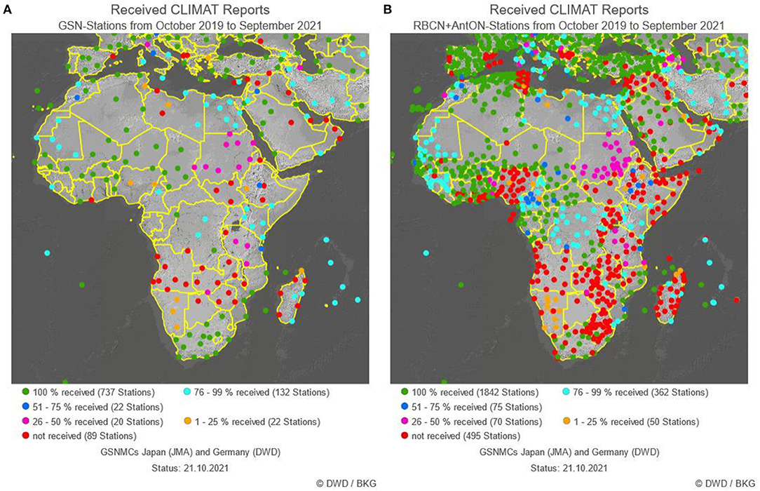
Figure 1. Percentage of monthly CLIMAT reports that have been received by one of the monitoring centers (at DWD and JMA) for the period October 2019 to September 2021 (i.e., a 24 months period). Percentage refers to the expected number of reports from each station. (A) Percentage of GSN-stations, (B) percentage for the RBCN- and AntON-stations. Both figures produced via the interactive website of the GSNMC: https://www.dwd.de/DWD-GCOS/EN/nationalcontributions/servicesforgcos/centresforqualityassurance/gsmnc/gsnmc_monitoring_produkte/gsnmc/climat_avail_new/climat_avail_node.html.
In order to feedback monitoring results from the GSNMC to the local network operators, regional CBS Lead Centers for GCOS have been designated by WMO to liaise with National Focal Points for GCOS, and other responsible officials, to improve data and metadata availability and quality. For Africa, two CBS Lead Centers were established, one in Morocco for northern Africa and a second one in Mozambique for southern Africa.
The need for improvement of local capacities for data handling and transmission has already been identified and initial steps have been undertaken (see section “International Cooperation”).
For assessments of long-term climate change, the observational time series should be as long as possible. Early observations are available for many regions in the world, but are often not yet available in digital form and the original documents from various countries might be archived at different places and in some cases even not yet identified (Brönnimann et al., 2018). The portal of the “International Data Rescue (I-DARE)” project provides an overview on the status of past and present worldwide data rescue projects and on known archives with historic weather data that are valuable to be rescued (https://www.idare-portal.org/). DWD houses huge archives of historical handwritten journals of weather observations originating also from the activities of his predecessor organizations. These archives do not only comprise observations from Germany, but also of the oceans and land stations in many parts of the world. Similarly, such historic observations can be found in archives of other national meteorological services. Some efforts to digitize the observations have been ongoing for decades and in recent years these activities were extended to previously untouched archive collections. An overview of DWD's data rescue activities was presented in (Kaspar et al., 2015a). International observations are part of the marine archive (located in DWD's branch office in Hamburg) which contains (among others) the collections of the German Naval Observatory, “Deutsche Seewarte,” a predecessor of DWD that existed from 1868 to 1945 in Hamburg. It includes meteorological data records from ships, as well as from land stations in many parts of the world (e.g., from former German colonies). The archives therefore also contain observations taken in Sub-Saharan African countries and also from the adjacent oceanic areas. The following sections provide further details on the specific collections.
The digitization process is a labor-intensive and therefore time-consuming activity, as at the current stage it can only be realized by manual key entry. To illustrate the typical appearance of such handwritten documents, Figure 2 shows an example from Cameroon (hourly temperature, taken in August 1913).
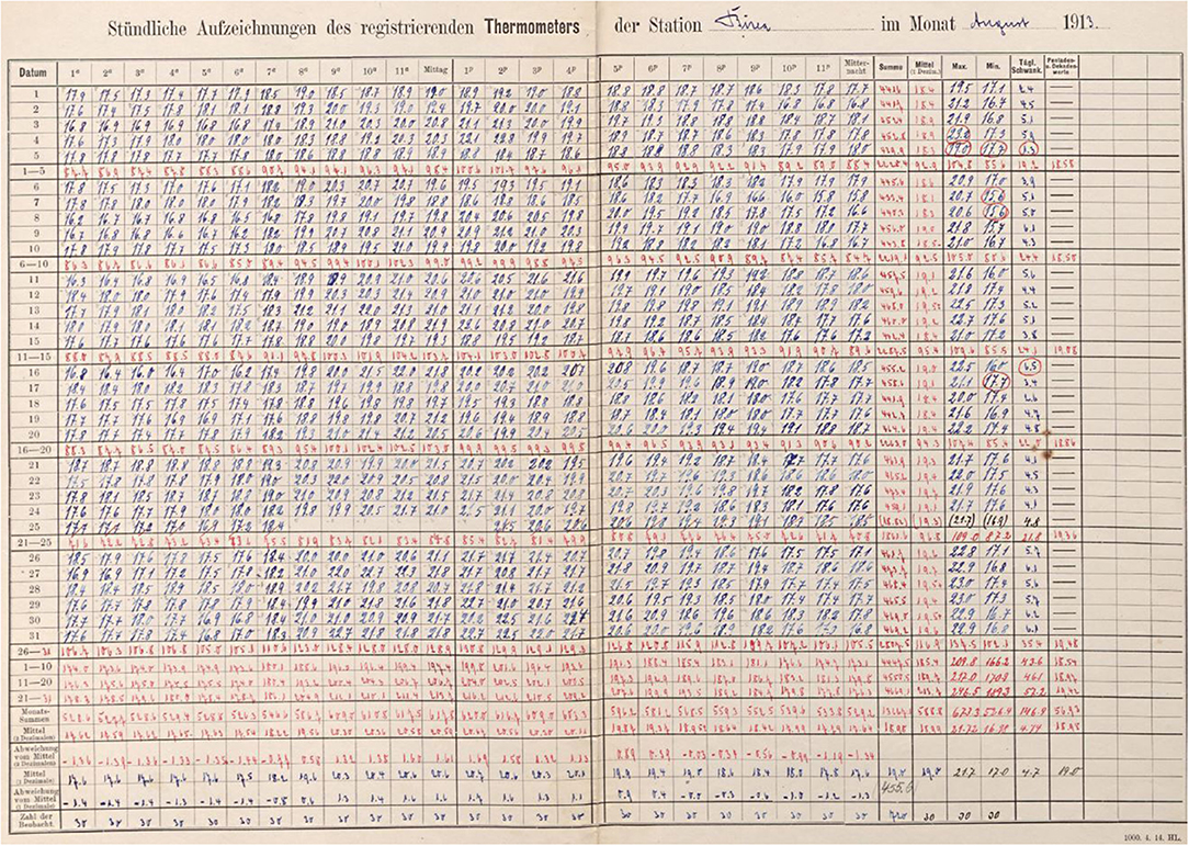
Figure 2. Hourly observations of the recording thermometer (thermograph) at station Buea (Cameroon) in August 1913.
The archive of the German Naval Observatory contains a collection of weather observations from more than 2,000 so-called “overseas” stations in many parts of the world, mainly in the former German colonies, including several countries in Sub-Saharan African. The “Deutsche Seewarte” equipped those stations with calibrated instruments and the meteorological observations were performed according to standardized rules. The archive contains climate data from the period 1830 to 1945, mainly from 1890 to 1945. Until now, more than 2,000 stations have been identified in the archive and data from 764 stations has been digitized in total (status: August 2021). About 1,700 of these stations are located in Africa and more than 400 are currently in the process of digitization or have been completed. The majority of the stations were located in Cameroon, Namibia and Tanzania. The stations were either set up as permanent stations measuring for several years, but also as interim or scientific stations for shorter periods of <1 year. Depending on the station type, either only precipitation was observed or a set of parameters including precipitation, temperature and weather data. Figure 3 illustrates the locations of the stations and the current status of the digitization process. Figure 4 shows the data availability over time in the major regions of Africa.
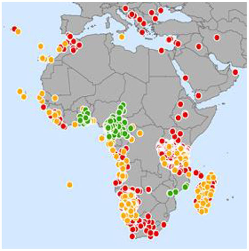
Figure 3. Station location and status of digitization effort for historical stations in the archive of DWD. Colors indicated the status as of 8/2021: Green, digitized and quality controlled; yellow, in progress; red, not yet digitized.
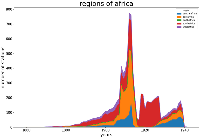
Figure 4. Availability of hand-written observations in the archive of the German Naval Observatory per year. The graph shows the number of stations in specific regions of Africa. The archive contains data from the following countries which are summarized by regions (stacked in the following order); (blue: Central Africa): Angola, Cameroon, Congo, Gabon; (orange: Eastern Africa): Ethiopia, Kenya, Tanzania; (green: Northern Africa): Egypt, Morocco; (red: Southern Africa): Madagascar, Mozambique, Namibia, South Africa, St. Helena; (purple: Western Africa): Benin, Cape Verde, Equatorial Guinea, Ivory Coast, Gambia, Ghana, Guinea, Guinea-Bissau, Liberia, Mali, Senegal, Sierra Leone, Togo.
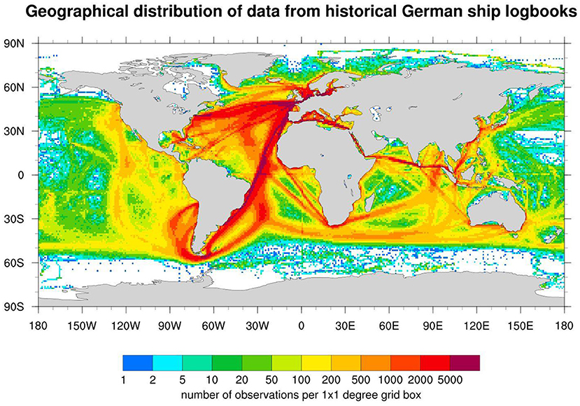
Figure 5. Geographical distribution of observations from historical ship logbooks digitized by Deutscher Wetterdienst (Status: 2021).
The archive of historical ship logbooks consists of several ship logbook collections from 1828 to 1945. As well as the overseas stations, the archive originates from the Deutsche Seewarte. With a stock of more than 37,000 meteorological ship logbooks, it is one of the world's largest archives of this kind. The first observations are from regular nautical logbooks. Similar to the standardized meteorological logbooks that were introduced by Maury (1840–1860), the German Marine Observatory started in 1868 to provide their own meteorological journals to German merchant ships. The majority of journals had been provided starting around 1870. After World War II, the marine-meteorological observations were continued by DWD.
The total number of marine observations in the historical archive of the Seewarte is estimated to be at least 23 million observations, and likely to be considerably more. Efforts to digitize the logbooks started in the early 1940s by transferring the data to punch cards. Since then, the digitization effort has been continued at DWD in several phases. Until now, about 15 million observations have been digitized and are collected in a digital data base. Figure 3 shows the geographical distribution of the digitized data. In particular, along the shipping routes around the Cape and to the former German colonies a substantial amount of historic marine meteorological observations provides important information about the climate and weather conditions for Africa.
A sophisticated workflow has been established to digitize the contents of the ship journals, consisting of several steps: gathering all metadata for a specific logbook, optical scanning of the logbooks and finally transcription (keying) of the contents. All digitized data from each step are stored in a database system. Finally, quality-controlled data are included in the DWD's marine meteorological archive as well as provided to the International Comprehensive Ocean-Atmosphere Data Set (ICOADS, see: Freeman et al., 2017).
Digitization efforts, not only at DWD, have been ongoing for decades in different projects (Allan et al., 2021). Consequently, the different data archive contents are fragmented, e.g., some documents were only partly digitized, or the database entries originate from different phases of digitization activities. For other datasets, the links to the respective metadata records have been lost over time. In the course of data exchange programs, some data has been duplicated in several archives. Hence, a further challenge, in addition to the integration of newly digitized data, is the consolidation and homogenization of these existing data archives.
The digitization effort of DWD still relies mostly on keying the observations by hand. Old German handwriting and varying data sheet layouts are still a challenge for automatic text recognition systems, which may be overcome by new techniques in the future, with the potential to significantly speed up the transcription process. However, the (meta)data management of the rescued data, as well as the handling and scanning of the old and fragile documents will continue to require a lot of careful work to create modern data sets of high quality from these valuable historical data sources (see also Allan et al., 2021 for further examples).
International data centers do not only collect and control weather observation; some of them also derive products in support of global and regional climate monitoring. One example is the Global Precipitation Climatology Centre (GPCC), which is operated by DWD under the auspices of the World Meteorological Organization (WMO). As final products, the GPCC provides global precipitation analyses for monitoring of the Earth's climate and related research. To achieve this aim, station-based precipitation observations are obtained from different sources, primarily from national meteorological services. The GPCC data archive is by far the largest worldwide for precipitation. The observations are quality-controlled, eventually corrected, archived and used to derive various gridded precipitation products for the Earth's land-surface, as e.g., monthly means. As an example, Figure 6A shows the long-term annual average precipitation in Africa on a spatial grid with 0.25° resolution. Figures 6C,D show the long-term average precipitation for two seasons (December, January, February and June, July, August) and illustrate, for example, the regionally pronounced change between dry and rainy seasons. Figure 6B shows the stations that were used for the production of the gridded dataset.
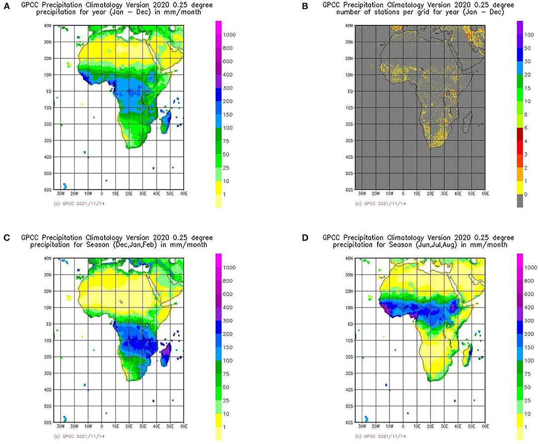
Figure 6. (A) Long term annual mean precipitation in Africa according to GPCC climatology - version 2020. (B) Number of stations per 0.25° grid cell used for the production of the climatology - (C) Long term mean precipitation for the season December, January, February. (D) Long term mean precipitation for the season June, July, August in Africa (https://kunden.dwd.de/GPCC/Visualizer).
The products of the GPCC are disseminated under an open data policy. However, the original station data are not published, as the GPCC does not claim copyrights on acquired data. GPCC applies a general policy not to pass any original station data but is in the position to provide data back to the original suppliers or country of origin, if requested (Becker et al., 2013). GPCC can thus support the development or improvement of national climate databases, as was already the case for Angola, for instance (Posada et al., 2016). In such cases, the national archives also benefit from the quality improvements implemented by GPCC.
The main steps performed at GPCC are:
1. Acquisition of precipitation data from meteorological and climate observation networks.
2. Quality-control and assessment of the collected data and correction of errors.
3. Estimation of a correction with respect to systematic gauge measuring errors.
4. Calculation of various gridded precipitation products for the Earth's land-surface, as e.g., monthly means; including error assessments at the gridcell level for some products.
5. Dissemination of the products under an open data license.
A variety of products are available that differ with regard to the underlying data, the temporal and spatial resolution and the intended application purpose. For near-real time products only a reduced amount of data is available with sufficient timeliness. They are therefore also produced at reduced spatial resolution. The full product portfolio is described in Schneider et al. (2016) and Becker et al. (2013) or on the website of GPCC (https://gpcc.dwd.de). Products with high relevance for Africa (but typically covering all inhabited continents) are:
• The “GPCC Climatology” provides gridded fields of monthly long-term climatological means with a spatial resolution up to 0.25°. It is based on monthly means focusing on the period 1951–2000 for ~85,000 stations worldwide (see Schneider et al., 2014 for a detailed description of an earlier version). Beyond its application as a reference climatology the dataset is also used as background fields for the anomaly interpolation of other GPCC products. Figures 6A,C,D shows the climatology for Africa for the annual mean and two seasons. Figure 6B illustrates the underlying density of stations.
• The “GPCC First Guess” products (daily and monthly) are based on synoptic weather reports (SYNOP messages) of ~7,000 stations (worldwide) arriving at DWD via WMO's Global Telecommunication System (GTS) in near-real time after observation. Maps and data products in a resolution of 1° are available within 5 days after the observation month and can therefore be used for applications that require high timeliness, e.g., drought monitoring (Schamm et al., 2014).
• The “GPCC Full Data Monthly” product provides monthly fields in a resolution of up to 0.25° for the period from 1891 onwards and is based on quality-controlled data from all stations in GPCC's database (with a maximum number of more than 53,000 stations in 1986/1987). The product is thereby optimized for applications that require best spatial coverage, e.g., verification of models or for analysis of historic global precipitation or research concerning the global water cycle.
• The “GPCC Full Data Daily” product provides daily information of global land-surface precipitation in a resolution of 1° and is based on data provided by national meteorological and hydrological services, global and regional data collections as well as WMO GTS-data. The temporal coverage of the dataset currently starts with January 1982.
• The “GPCC Drought Index” is a standardized anomaly of precipitation and potential evapotranspiration relative to long term means to be applied for, e.g., drought monitoring (Ziese et al., 2014). It is available in a version with high timeliness and a version regarding long term means for the period from 1952 onwards. Aggregation periods of 1, 3, 6, 9, 12, 24, and 48 months are calculated.
Figure 7 shows the number of stations in Africa per year that are available for the generation of these products. Near-real time products (“first guess”) are based on observations received via WMO's Global Telecommunication System (GTS data). For the “Full Data” products, additional stations are available, which have been integrated into the archive based on national contributions and by integrating data from international databases. The contributions of the National Meteorological and Hydrological Services are an essential part of the database. Overall, GPCC received monthly data from about 4,500 stations in Africa for the period 1971–1990 and from a maximum of over 5,000 stations. In earlier and later years, the number of stations is smaller.
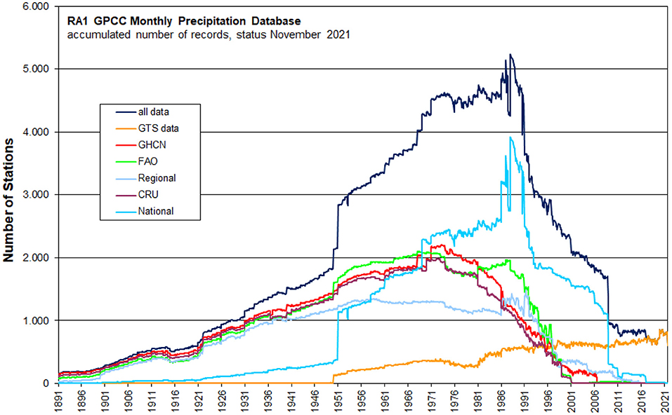
Figure 7. Number of stations per year in the GPCC data base per data source for WMO-region “RA 1” (Africa) and accumulated amount (dark blue). GTS, Global Telecommunication System; GHCN, Global Historical Climatology Network; FAO, Food and Agriculture Organization; CRU, Climatic Research Unit.
The previous section illustrated activities at the international level in support of data quality and the availability of ground-based observations and derived products. However, for provision of climate services at the national level, it is also important to improve the local capacity to operate stations networks and to build up climate databases to support local applications ranging from analysis of climate trends to data provision for all types of applications in support of adaptation measures. Such tasks are typically under the responsibility of national meteorological services. Some initiatives in recent years have demonstrated how international cooperation can contribute to an improvement of local capacities, partly also linked to the above-mentioned activities.
It is generally accepted that relevant gaps in observing networks persist and results of projects aiming at a strengthening of these networks have often been suboptimal (Santamaria et al., 2021). The need for capacity enhancements in developing countries is therefore also addressed in the WMO Strategic Plan 2020–2023 (WMO, 2019), but technical and financial support is needed to achieve significant improvements (Kijazi et al., 2021). A questionnaire of WMO (2012) on Climate Data Management Systems led to the conclusion that several NMHSs in developing countries do not operate database management systems (DMS) for their climate data management systems (CDMSs).
An example of an initiative with focus on both, observation networks and climate data bases, are the activities which have been jointly performed within the framework of the “Southern African Science Service Centre for Climate Change and Adaptive Land Management” (SASSCAL; https://www.sasscal.org). Within SASSCAL, the national weather authorities of Angola, Botswana, Germany and Zambia as well as further partner institutions in Germany, Namibia and South Africa, cooperated to support the extension of the regional meteorological observation network and the improvement of the climate archives at national level in the respective countries (Kaspar et al., 2015b). To improve the low density of climate stations in the SASSCAL region the establishment of a network of weather stations was started in 2009/2010 and a total of 154 weather stations were reached. Important strategic and technical steps of this activity are discussed by Muche et al. (2018). This extension of the network was complemented by activities to improve the climate data management concepts at the national weather authorities. In addition to training activities, a focus was also on the extension of the data bases with historical climate data. Those were partly obtained by digitization efforts in the countries, but also by identifying additional sources in international archives, as e.g., the above-mentioned archive of precipitation data of the GPCC. It was found that some of these data were no longer available in some national databases. Details of the activities are described in Posada et al. (2016, 2018) and (Kaspar et al., 2015b). The CDMS used in the participating countries is Climsoft, a system frequently used in developing countries. In the meantime, efforts were ongoing to develop this system toward a free Open Source Climate Data Management System (https://climsoft.org).
The national and regional data archives can also be complemented by integrating the historic observations from the above-mentioned digitization efforts of DWD or other NHMSs. The provision of historic weather observations from the overseas archive to the countries where the stations were originally located is therefore an important initiative that is currently supported on a case-by-case basis, depending on progress in digitization. For example, a complete digital copy and data package of the documents contained in the archive of the former colonial stations in Cameroon were officially handed over by DWD to the diplomatic representation of Cameroon and is forwarded to the “Direction de la Météorologie Nationale du Cameroun” (CMR). Similar data transfers have already been made for other stations, e.g., in Canada, China and Korea, and will be continued for other countries, when the respective data has been digitized, documented and quality controlled.
In addition to ground-based observations, satellite data can also provide climatological information, but the feasibility depends on the meteorological parameter. For example, cloudiness and surface radiation can be derived from observations of meteorological satellites. Meteorological satellites have now been in operation for some decades and therefore can provide data of appropriate length for climatological analyses. The METEOSAT satellites are located at a position over the equator from where they are in an optimal position to provide information for Africa (see Figure 8). The first METEOSAT satellite was launched in 1977. However, the satellites were originally not intended to provide long term climate information and therefore the data need careful processing and inter-calibration between satellites to provide reliable products for climatological applications. Such work is done at the Satellite Application Facility on Climate Monitoring (CM SAF, https://www.cmsaf.eu), a EUMETSAT activity organized as a network with contributions from several national meteorological services in Europe and led by DWD. The derived data products are available with a spatial resolution of a few kilometers and therefore at much higher resolution than the typical density of ground-based observations of radiation or cloudiness. Especially surface radiation, but also cloudiness, are important parameters for applications in the energy sector or for modeling evaporation in applications related to water or vegetation. A relevant example of such datasets is the surface solar radiation data set SARAH-2. The “second edition of the Surface Solar Radiation Data Set - Heliosat” (SARAH-2, together with the update to SARAH-2.1) is a satellite-based climate data record of a set of radiation parameters: solar surface irradiance, surface direct irradiance (direct horizontal and direct normalized), sunshine duration, spectral information, and the effective cloud albedo. They are derived from satellite-observations of the visible channels of the MVIRI and the SEVIRI instruments onboard the geostationary METEOSAT satellites (Kothe et al., 2017; Pfeifroth et al., 2017, 2018, 2019). The data are available from 1983 to 2017 and cover the region ±65° longitude and ±65° latitude (Figure 8; ±60° longitude and ±60° latitude for the spectral information), thereby providing information for all of Africa. The products are available as monthly and daily means, and as 30-min instantaneous data (sunshine duration is available as monthly and daily sum) on a regular latitude/longitude grid with a spatial resolution of 0.05° × 0.05° degrees. In addition to the SARAH-2.1 data set, CM SAF provides a day-to-day continuation of the data records. A completely new update of the SARAH-2.1 is currently being produced in the CM SAF and will be made available in 2022 as SARAH-3, then covering the years 1982–2020. Similar to other products of CM SAF, the data set is freely available and complemented with a comprehensive documentation of the algorithms, a validation report and user guidance.
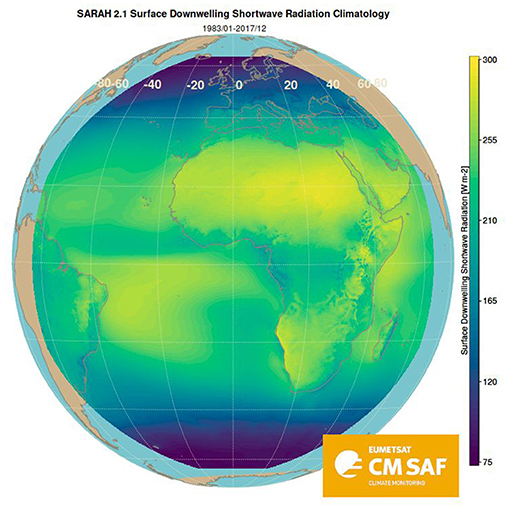
Figure 8. Spatial distribution of mean surface solar radiation (global radiation) in the period 1983–2017 based on the CM SAF SARAH-2.1 data set.
Similarly, datasets for cloud parameters are available covering the same region and time period (e.g., Benas et al., 2017). Such satellite products can therefore complement ground-based observations, but only for selected parameters. For instance, deriving near-surface temperature or near-surface wind is currently not possible in a comparable quality at the global or continental scale.
There continue to be relevant gaps in the availability of meteorological data in Sub-Saharan Africa. The monitoring of data availability as implemented within the GCOS Surface Network Monitoring Centre provides an overview of data that have been received and are available for climate analysis at the international level. The results reveal gaps especially in Southern and Eastern Africa. Although Africa is considered a vulnerability “hot spot” for climate variability and change impacts (WMO, 2020), the gaps in the data availability hinder detailed assessments of the climate change that has already taken place. The need for improvements and financial support is discussed at the international level (e.g., Santamaria et al., 2021). Cooperation between national meteorological agencies can support capacity building at the national level and some initiatives of the last few years can provide some lessons learned, as e.g., the activities within SASSCAL where cooperations between Germany and countries in Southern Africa were established. Establishing climate data bases at the national level in developing countries can also benefit from the digitization of historical data in archives of European meteorological agencies. Such additional data will be especially valuable for assessment of long-term climate change. However, this digitization continues to be a labor-intensive process.
Some parameters can also be derived from satellite observations. Datasets covering some decades have been produced, e.g., at EUMETSAT's Satellite Application Facility on Climate Monitoring and provide information for Africa at high spatial and temporal resolution. In particular, radiation, sunshine duration or cloudiness are relevant parameters for a wide range of applications and are available from this activity.
For precipitation, a portfolio of datasets is provided by the Global Precipitation Climatology Centre (GPCC). They are based on station-based observations. Gridded products are openly available. The original station data can be handed over to the country of origin to be included in national climate databases. Improving the international data exchange will also improve the quality of such products from global data centers.
These activities of Germany's national meteorological service (Deutscher Wetterdienst, DWD) are examples for international contributions to the improvement of climate data availability and quality in Sub-Saharan Africa. They illustrate that a variety of activities are needed to achieve a comprehensive understanding of climate variability and change. Improving data availability and exchange will not only support the understanding of climate trends, but will also support applications as especially numerical weather forecasting (Meque et al., 2021). The combination of observations and numerical models also allows to generate long-term climate reanalysis datasets that provide realistic three-dimensional fields of past weather and are therefore used in a wide range of applications. These activities also benefit from digitized historic observations which are used in the data assimilation of these models. Such datasets exist as products with global coverage (e.g., produced within the European Copernicus Climate Change Service; Hersbach et al., 2020) or as regional products with higher resolution for some continents (e.g., Kaspar et al., 2020), but not yet for the African continent.
FK drafted the manuscript with input from all co-authors. All authors contributed to the article and approved the submitted version.
DWD's contribution to SASSCAL was funded by Germany's Ministry for Education and Research (BMBF, grant no. 01LG1201J). The Satellite Application Facility on Climate Monitoring (CM SAF) is an integral part of the distributed EUMETSAT Application Ground Segment. It is a joint activity of national meteorological services and research institutes from Belgium, Finland, The Netherlands, Sweden, Switzerland, United Kingdom, France and Germany, as leading entity, and co-sponsored by EUMETSAT.
The authors declare that the research was conducted in the absence of any commercial or financial relationships that could be construed as a potential conflict of interest.
All claims expressed in this article are solely those of the authors and do not necessarily represent those of their affiliated organizations, or those of the publisher, the editors and the reviewers. Any product that may be evaluated in this article, or claim that may be made by its manufacturer, is not guaranteed or endorsed by the publisher.
We thank our colleagues for producing Figure 4 (Tobias Detels), Figure 7 (Jan Nicolas Breidenbach), and Figure 8 (Steffen Kothe). We also thank the reviewers for their helpful comments on the manuscript.
Allan, R., Wood, K., Freeman, E., Wilkinson, C., Andersson, A., Lorrey, A., et al. (2021). Learning from the past to understand the future: historical records of change in the ocean. WMO Bull. 70, 36–42. Available online at: https://library.wmo.int/doc_num.php?explnum_id=10595 (accessed January 9, 2022).
Becker, A., Finger, P., Meyer-Christoffer, A., Rudolf, B., Schamm, K., Schneider, U., et al. (2013). A description of the global land-surface precipitation data products of the Global Precipitation Climatology Centre with sample applications including centennial (trend) analysis from 1901–present. Earth Syst. Sci. Data 5, 71–99. doi: 10.5194/essd-5-71-2013
Benas, N., Finkensieper, S., Stengel, M., van Zadelhoff, G.-J., Hanschmann, T., Hollmann, R., et al. (2017). The MSG-SEVIRI-based cloud property data record CLAAS-2. Earth Syst. Sci. Data 9, 415–434. doi: 10.5194/essd-9-415-2017
Brönnimann, S., Brugnara, Y., Allan, R. J., Brunet, M., Compo, G. P., Crouthamel, R. I., et al. (2018). A roadmap to climate data rescue services. Geosci. Data J. 5, 28–39. doi: 10.1002/gdj3.56
Freeman, E., Woodruff, S. D., Worley, S. J., Lubker, S. J., Kent, E. C., Angel, W. E., et al. (2017). ICOADS Release 3.0: a major update to the historical marine climate record. Int. J. Climatol. 37, 2211–2232. doi: 10.1002/joc.4775
Hersbach, H., Bell, B., Berrisford, P., Hirahara, S., Horányi, A., Muñoz-Sabater, J., et al. (2020). The ERA5 global reanalysis. Q. J. Roy. Meteorol. Soc. 146, 1999–2049. doi: 10.1002/qj.3803
Karl, T. R., Diamond, H. J., Bojinski, S., Butler, J. H., Dolman, H., Haeberli, W., et al. (2010). Observation needs for climate information, prediction and application: capabilities of existing and future observing systems. Proc. Environ. Sci. 1, 192–205. doi: 10.1016/j.proenv.2010.09.013
Kaspar, F., Helmschrot, J., Mhanda, A., Butale, M., Hillmann, T., Josenhans, K., et al. (2015b). The SASSCAL contribution to climate observation, climate data management and data rescue in Southern Africa. Adv. Sci. Res. 12, 171–177. doi: 10.5194/asr-12-171-2015
Kaspar, F., Niermann, D., Borsche, M., Fiedler, S., Keller, J., Potthast, R., et al. (2020). Regional atmospheric reanalysis activities at Deutscher Wetterdienst: review of evaluation results and application examples with a focus on renewable energy. Adv. Sci. Res. 17, 115–128. doi: 10.5194/asr-17-115-2020
Kaspar, F., Tinz, B., Mächel, H., and Gates, L. (2015a). Data rescue of national and international meteorological observations at Deutscher Wetterdienst. Adv. Sci. Res. 12, 57–61. doi: 10.5194/asr-12-57-2015
Kijazi, A., Konate, D., Ngari, A., and Laing, A. (2021). No member left behind - part 1: a developing country perspective on data exchange in meteorology. WMO Bull. 70, 70–75. Available online at: https://library.wmo.int/doc_num.php?explnum_id=10874 (accessed January 9, 2022).
Kothe, S., Pfeifroth, U., Cremer, R., Trentmann, J., and Hollmann, R. (2017). A Satellite-Based Sunshine Duration Climate Data Record for Europe and Africa. Remote Sens. 9, 429. doi: 10.3390/rs9050429
Meque, A., Gamedze, S., Moitlhobogi, T., Booneeady, P., Samuel, S., and Mpalang, L. (2021). Numerical weather prediction and climate modelling: challenges and opportunities for improving climate services delivery in Southern Africa. Clim. Serv. 23:100243. doi: 10.1016/j.cliser.2021.100243
Muche, G., Kruger, S., Hillmann, T., Josenhans, K., Ribeiro, C., Bazibi, M., et al. (2018). SASSCAL WeatherNet: present state, challenges, and achievements of the regional climatic observation network and database, in Climate Change and Adaptive Land Management in Southern Africa – Assessments, Changes, Challenges, and Solutions, Biodiversity & Ecology, Vol. 6, eds R. Revermann, K. M. Krewenka, U.Schmiedel, J. M. Olwoch, J. Helmschrot and N. Jürgens (Göttingen & Windhoek: Klaus Hess Publishers). doi: 10.7809/b-e.00302
Pfeifroth, U., Kothe, S., Müller, R., Trentmann, J., Hollmann, R., and Fuchs, P. (2017). Surface Radiation Data Set - Heliosat (SARAH) - Edition 2, Satellite Application Facility on Climate Monitoring. doi: 10.5676/EUM_SAF_CM/SARAH/V002
Pfeifroth, U., Kothe, S., Müller, R., Trentmann, J., Hollmann, R., and Fuchs, P. (2019). Surface Radiation Data Set - Heliosat (SARAH) - Edition 2.1. Offenbach: Satellite Application Facility on Climate Monitoring. doi: 10.5676/EUM_SAF_CM/SARAH/V002_01
Pfeifroth, U., Sanchez-Lorenzo, A., Manara, V., Trentmann, J., and Hollmann, R. (2018). Trends and variability of surface solar radiation in europe based on surface- and satellite-based data records. J. Geophys. Res. Atmos. 123, 1735–1754, doi: 10.1002/2017JD027418
Posada, R., Nascimento, D., Francisco Neto, O. S., Riede, J. O., and Kaspar, F. (2016). Improving the climate data management in the meteorological service of Angola: experience from SASSCAL. Adv. Sci. Res. 13, 97–105. doi: 10.5194/asr-13-97-2016
Posada, R., Riede, J. O., Kaspar, F., Mhanda, A., Radithupa, M., Stegling, J., et al. (2018). Cooperation of meteorological services within SASSCAL on improving the management of observed climate data, in Climate Change and Adaptive Land Management in Southern Africa – Assessments, Changes, Challenges, and Solutions, Biodiversity & Ecology, Vol. 6, eds R. Revermann, K. M. Krewenka, U. Schmiedel, J. M. Olwoch, J. Helmschrot and N. Jürgens (Göttingen & Windhoek: Klaus Hess Publishers), 22–29. doi: 10.7809/b-e.00297
Santamaria, L., Riishojgaard, L. P., Harding, J., Larroquette, B., and Zoetelief, J. (2021). No Member Left Behind - Part 2: development partners' perspectives on overcoming sustainability challenges in observing networks and data exchange - lessons learned. WMO Bull. 70, 76–82.
Schamm, K., Ziese, M., Becker, A., Finger, P., Meyer-Christoffer, A., Schneider, U., et al. (2014). Global gridded precipitation over land: a description of the new GPCC First Guess Daily product. Earth Syst. Sci. Data 6, 49–60. doi: 10.5194/essd-6-49-2014
Schneider, U., Becker, A., Finger, P., Meyer-Christoffer, A., Ziese, M., and Rudolf, B. (2014). GPCC's new land surface precipitation climatology based on quality-controlled in situ data and its role in quantifying the global water cycle. Theoret. Appl. Climatol. 115, 15–40. doi: 10.1007/s00704-013-0860-x
Schneider, U., Ziese, M., Meyer-Christoffer, A., Finger, P., Rustemeier, E., and Becker, A. (2016). The new portfolio of global precipitation data products of the Global Precipitation Climatology Centre suitable to assess and quantify the global water cycle and resources. Proc. IAHS 374, 29–34. doi: 10.5194/piahs-374-29-2016
WMO (2009). Handbook on CLIMAT and CLIMAT TEMP Reporting. WMO-No. 1188. Geneva: World Meteorological Organization.
WMO (2012). Status of Worldwide Implementation and Use of Climate Data Management Systems (CDMS) in NMHSs - Analysis of a CCl Questionnaire. Geneva: World Meteorological Organization.
WMO (2020). State of the Climate in Africa 2019. WMO-No. 1253. Geneva: World Meteorological Organization. Available online at: https://library.wmo.int/doc_num.php?explnum_id=10421 (accessed January 09, 2022).
Keywords: climatology, climate data, climate monitoring, weather observation, Africa, precipitation, data rescue, satellite climatology
Citation: Kaspar F, Andersson A, Ziese M and Hollmann R (2022) Contributions to the Improvement of Climate Data Availability and Quality for Sub-Saharan Africa. Front. Clim. 3:815043. doi: 10.3389/fclim.2021.815043
Received: 14 November 2021; Accepted: 28 December 2021;
Published: 02 February 2022.
Edited by:
Gregory Husak, University of California, Santa Barbara, United StatesReviewed by:
Tufa Dinku, Columbia University, United StatesCopyright © 2022 Kaspar, Andersson, Ziese and Hollmann. This is an open-access article distributed under the terms of the Creative Commons Attribution License (CC BY). The use, distribution or reproduction in other forums is permitted, provided the original author(s) and the copyright owner(s) are credited and that the original publication in this journal is cited, in accordance with accepted academic practice. No use, distribution or reproduction is permitted which does not comply with these terms.
*Correspondence: Frank Kaspar, ZnJhbmsua2FzcGFyQGR3ZC5kZQ==
Disclaimer: All claims expressed in this article are solely those of the authors and do not necessarily represent those of their affiliated organizations, or those of the publisher, the editors and the reviewers. Any product that may be evaluated in this article or claim that may be made by its manufacturer is not guaranteed or endorsed by the publisher.
Research integrity at Frontiers

Learn more about the work of our research integrity team to safeguard the quality of each article we publish.