- 1Collaborative Innovation Centre on Forecast and Evaluation of Meteorological Disasters, School of Atmospheric Physics, Nanjing University of Information Science and Technology, Nanjing, China
- 2Guangzhou Institute of Tropical and Marine Meteorology, China Meteorological Administration, Guangzhou, China
- 3College of Oceanic and Atmospheric Sciences, Ocean University of China, Qingdao, China
Using the ERA5 (the fifth major global reanalysis produced by the European Centre for Medium-Range Weather Forecasts) data and the T-PCA (Principal Component Analysis in T-mode) objective classification method to classify the 850-hPa geopotential height, we summarize four conceptual models of large-scale synoptic weather types over East Asia. By combining this with the daily precipitation observation data of 36 meteorological stations in Guangdong, South China, during summer (June to August) of 2014–2018, we found that summer precipitation in Guangdong Province is closely related to the position of the northwestern Pacific subtropical high and the strong upward motion of the warm airflow over the Pearl River Delta. It is further revealed the regulation effect of different weather patterns on summer precipitation in Guangdong Province and their urban–rural differences. More specifically, both urban and rural areas have a decreasing proportion of light rainfall and an increasing proportion of heavy and torrential rainfall, which are mainly regulated by the trend of frequency changes of four different weather types: Type 1 (47.39%) and Type 2 (32.39%) days are decreasing year by year, modulating the trend of light rainfall, while Type 3 (13.26%) and Type 4 (6.96%) days are steadily increasing, dominating the trend of heavy rainfall. In addition, it was further found that the frequency of light rainfall is decreasing more significantly in cities compared to that in rural areas, while the proportion of heavy and stormy rainfall is increasing more significantly, which is closely related to the effects of rapid urbanization.
Introduction
Precipitation is an important factor reflecting the atmospheric circulation characteristics and climate change. Also, uneven spatial distribution and temporal variability of extreme precipitation can directly or indirectly cause serious losses to agricultural production and adverse impacts on human society. For example, on 21 July 2012, Beijing and its surrounding areas were hit by extreme heavy rainfall, resulting in flooding, and traffic congestion, with direct and indirect economic losses totaling ~$1.88 billion (Guo et al., 2015). In August 2014, a strong rainstorm with a 3-h rainfall of more than 200 mm occurred in Hiroshima, Japan, resulting in mudslides and landslides that killed 74 people and destroyed 133 houses (Wang et al., 2015b). With continuous socioeconomic development, the level of damage caused by heavy rainfall is increasing. Therefore, improving our understanding of precipitation—especially its characteristics in mega-city clusters—can help us to develop more advanced early warning and emergency response initiatives in the face of large-scale disasters, as well as better post-disaster recovery actions.
South China is under the combined influence of the subpolar westerlies system and tropical weather system, which means it has an abundant source of moisture and is one of the regions with the most precipitation in China. It has a long period of flooding, lasting from April to September (Ramage, 1952), and heavy precipitation occurs frequently (Yali et al., 2016; Zheng et al., 2016). The flood season can be divided into a pre-flood period (April-June), when precipitation is influenced by the interaction of complex multi-scale weather systems, and a post-flood period, when heavy precipitation is closely associated with tropical cyclones (Luo, 2017). Due to the complex mechanism of influencing precipitation, different synoptic patterns have strong correlation with the regional distribution and intensity of precipitation in Guangdong (Li et al., 2021). As the climate warms, the frequency and intensity of extreme precipitation increases in the world's dry and wet regions (Donat et al., 2016). It has been shown in previous study that the frequency of heavy and extreme precipitation events in South China has increased significantly from 1979–2015. The increasing trend in urban areas is more obvious, compared with non-urban areas (Su et al., 2019). The spatial and temporal variation of different levels of precipitation in South China over the past 50 years indicates a significant decrease in maunder and light rainfall and a slight increase in moderate to heavy precipitation (Chuanbo and Li, 2014). The Pearl River Delta (PRD) region has experienced a rapid urbanization since China's “Economic Reform and Open Up” period, and it is one of the largest urban agglomerations in China. Observational data and simulations over the past few decades show a strong link between urbanization and precipitation (Wang et al., 2015a,c,d; Holst et al., 2016; Cristiano et al., 2017; Lijie et al., 2020). The frequency of rainstorms and extreme rainfall in the PRD region show an increasing trend, being more pronounced during the warm season (May–October) and the pre-flood period (Yan et al., 2020). Liu et al. (2021) found that rapid urbanization on shorter time scales has tended to increase precipitation in the PRD; for example, they found that the maximum continuous 3-h precipitation correlates strongly with urban extent. The reason for this trend might be that, although urban surface evaporation decreases, increased moisture flux convergence and the availability of water vapor from the ocean still support stronger extreme rainfall in the PRD's mega-cities (Hu et al., 2021). In addition, Chen et al. (2021) comprehensively assessed the flood risk in the PRD in the future (2030–2050) by building a flood risk model, and the results showed that climate change and urbanization will exacerbate flood risk in most parts of the PRD in the coming decades, while extreme precipitation events will become more severe.
Since the 1970s, China has conducted several large-scale scientific observation experiments in South China (Chen and Chen, 1995; Hong and Zhao, 2004; Ni et al., 2006; Luo et al., 2016). Amongst their many achievements, the results of these experiments have revealed the underlying physical mechanism of convective rainstorms, from their triggering to development, during the pre-flood period in South China, as well as elucidated the relationship between different stages of monsoon development and the microphysical structural characteristics of South China's precipitation systems (Chen and Chen, 1995; Hong and Zhao, 2004; Ni et al., 2006; Luo et al., 2016). Previous studies have mostly focused on precipitation during the pre-flood period and around the monsoon burst in South China. By contrast, few studies have sought to objectively classify the meteorological characteristics of summer (June–August) precipitation in Guangdong. Especially in the context of rapid urbanization, the synergistic effects of interannual changes in weather circulation and urbanization on precipitation in South China are still unclear.
To provide a reference base for summer precipitation forecasting, flood disaster warning and disaster prevention and mitigation in Guangdong Province, in this paper we show a statistical analysis of circulation patterns in the summers of 2014–2018 base on daily observational precipitation data by objective classification method. We then explore the influence of different weather patterns on each level of precipitation, and further discuss the spatial and temporal distribution characteristics of precipitation in Guangdong under the rapid urbanization that has taken place during this study period.
Data and Methods
Data
The fifth major global reanalysis produced by the European Center for Medium Weather Forecasting (ECMWF), referred to as ERA5, was used to classify and analyze the atmospheric circulation. The resolution of the data is 0.25° × 0.25°, and the geopotential heights, horizontal all-winds (i.e., zonal (U) and meridional (V)), vertical winds, and temperatures from June to August 2014–2018 were selected as variables for the synoptic analysis of summer precipitation in this study. Figure 1 shows the distribution of 36 ground-based stations of urban and rural stations in Guangdong Province.
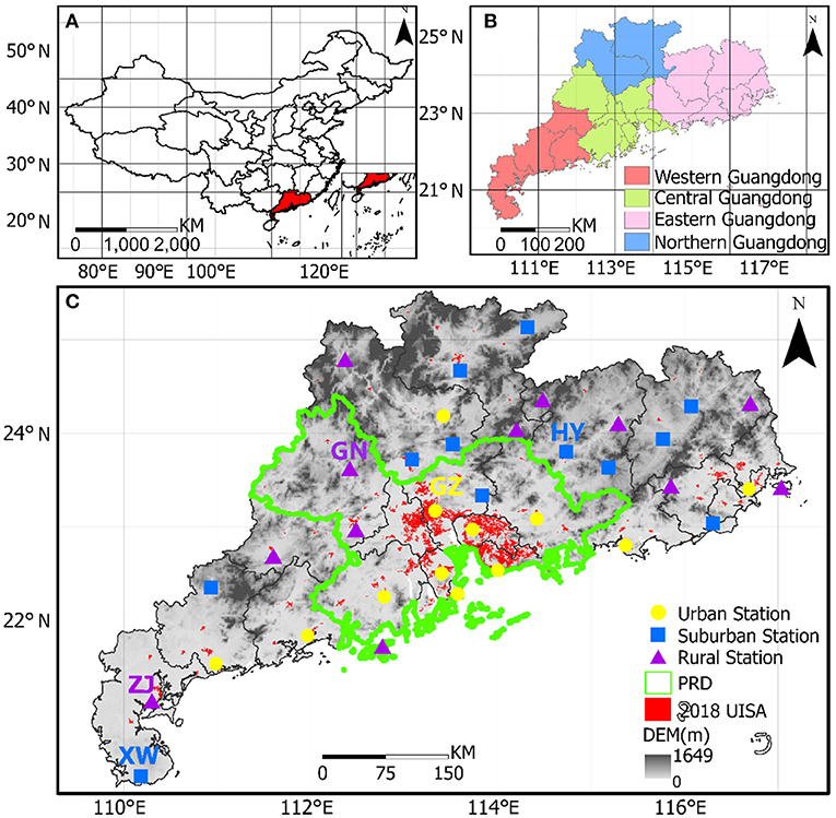
Figure 1. (A) Geography of Guangdong Province. (B) Four sub-regions of Guangdong Province. (C) Distribution of urban, suburban and rural stations in Guangdong Province (superimposed on impermeable-surface data for 2018); https://zenodo.org/record/3778424#.XvfmQ-e-uUk.
Method
Objective Classification of Synoptic Patterns
The objective weather classification method employed in this study is a computer-based mathematization of an objective measure of data similarity and variance that can handle pre-determined dominant weather models without relying on individual subjective perceptions and pre-determined parameters (Huth, 1996; Huth et al., 2008). Specifically, the T-PCA (Principal Component Analysis in T-mode) method was used to perform a multivariate oblique cross-rotation decomposition of the 850-hPa geopotential height using the weather classification software COST733 developed by the European Science and Technology Research Program (Philipp et al., 2014). In order to evaluate the performance of synoptic classification and determine the number of classes, the explained cluster variance (ECV) is selected in this study (Ning et al., 2019, 2020). The detailed information about the T-PCA and ECV is also provided in Text S1 and S2 in the Supplementary Materials.
Method for Station Classification
In this paper, we mainly refer to the classification methods of satellite remote sensing data of Yang et al. (2013) and Li et al. (2015) to identify the subsurface around the station: (1) urban stations: the proportion of built-up area within the 2-km buffer zone around the station is ≥50%; (2) suburban stations: the proportion of built-up area within the 2-km buffer zone around the station is between 25% and 50%; (3) rural stations: the proportion of built-up area within the 2 km buffer zone around the station was <25%. Based on this approach, 12 urban, 12 suburban, and 12 rural stations were selected (See Supplementary Figure 1), and the distribution of stations is shown in Figure 1C. Ultimately, based on the differences in local precipitation patterns, sunlight and latitude, and the urbanization level of different regions, Guangdong Province was divided into four regions: Western Guangdong, Central Guangdong, Eastern Guangdong, and Northern Guangdong (Figure 1B). The differences in precipitation between urban stations and one or more nearby rural reference stations in each subregion were then further calculated to discuss the effects of urbanization on precipitation. The analysis of variance (ANOVA) test and Mann-Kendall test were conducted to assess the statistical significances of the differences in rainfall between urban and rural stations.
Classification of Precipitation Levels
In order to study the correlation between weather patterns and precipitation levels, we selected 24-h precipitation data and classifies the observed daily rainfall into six intensity levels according to the criteria of the China Meteorological Administration, which are shown in Table 1.
Results and Discussion
Dominant Synoptic Patterns
The objective weather classification method was used to objectively classify the 850-hPa sea level pressure geopotential height field for the summers of 2014–2018, from which four weather types were obtained, then wind and temperature were composite analysis. Figure 2 shows the distribution of the 850-hPa geopotential height, wind field, and temperature field synthesized by the four weather types: The frequency of Type 1 is 47.39%, in which the dominant wind is southwesterly in Guangdong; Type 2 is the southerly wind type (frequency: 32.39%), in which the dominant wind direction in Guangdong Province is southerly, with a small amount of southwesterly wind on the east side; Type 3 is the eastern subtropical high type (frequency:13.26%), in which Guangdong Province is to the west of the Western Pacific subtropical high. The dominant wind direction in Guangdong Province is southwesterly and the wind speed is high; And Type 4 is the northern low-pressure type (frequency: 6.96%), in which Guangdong Province is located to the south of low pressure, the dominant (but low) wind speed is southerly and southwesterly, and has the lowest frequency of weather systems.
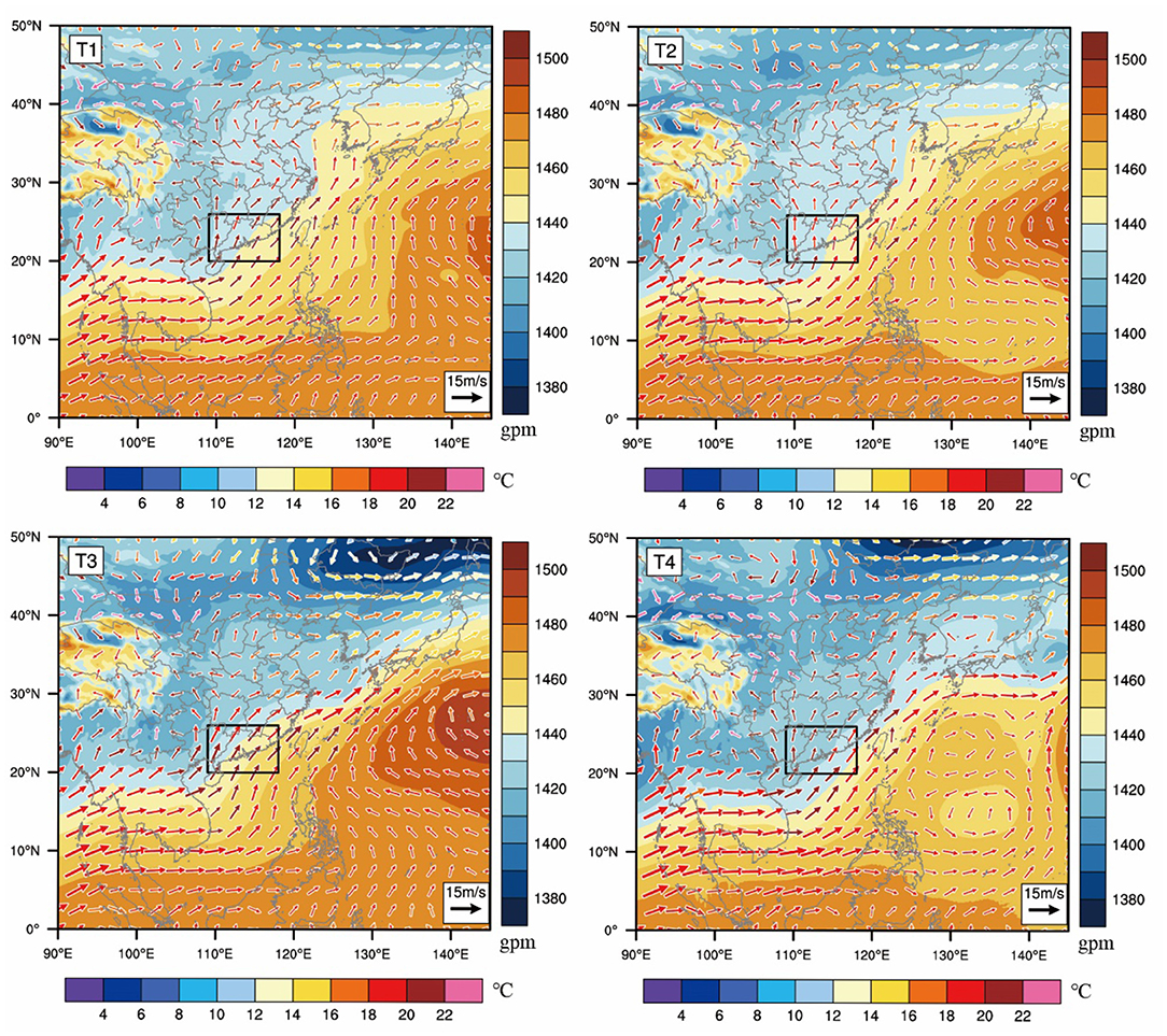
Figure 2. The geopotential height (shaded) and 850 hPa wind with temperature (color vector) in four different weather types (T1–T4). The boxed area in panels encloses the Guangdong.
The temporal distribution series of the four weather types (Figure 3A) and the month-by-month frequency of each weather type (Figure 3B) for a total of 460 days during the summers of 2014–2018 show that: Type 1 occurs mainly in June; Type 2 occurs mostly in July and August; the average frequency of Type 3 (13.26%) is less than 20% and occurs in every summer months; and Type 4 only occurs in 2016–2018. The trend of monthly frequency curves of the four weather types can be found that the frequency of Type 1 and Type 2 is decreasing, while the frequency of Type 3 and Type 4 is steadily increasing during 2014–2018.
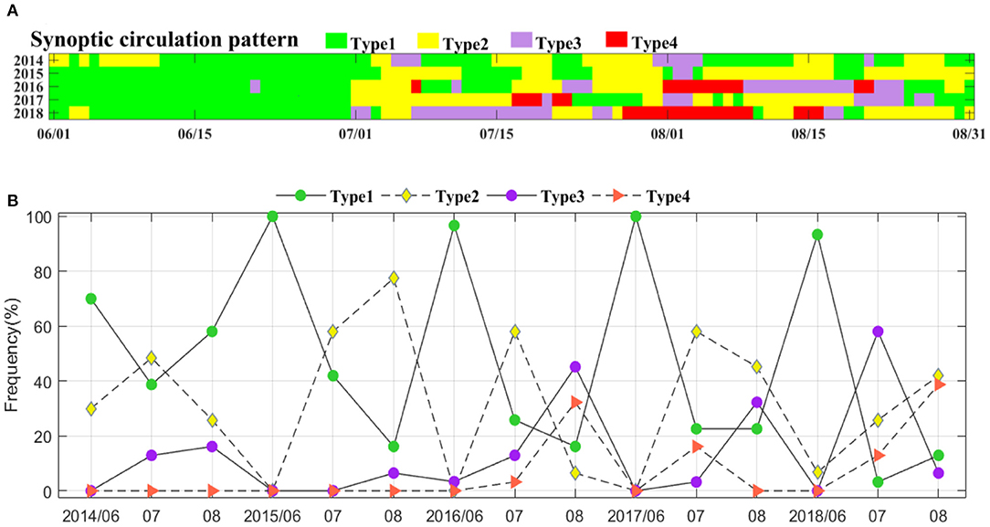
Figure 3. (A) Time distribution series of the four weather patterns (B) Month-by-month frequency of each weather pattern.
Precipitation in Relation to Synoptic Patterns
Figure 4 shows the spatial distribution of the average daily precipitation under the four weather patterns, respectively. Generally speaking, under these four weather patterns, the high daily precipitation occurs in the urban-cluster area of the PRD and the central coastal region. The average daily precipitation in eastern Guangdong is the least, followed by northern Guangdong, and the average daily precipitation in central Guangdong is the largest, mainly because the precipitation situation here is most influenced by the urbanization of dense urban areas. Specifically, daily precipitation in the four sub-regions of Guangdong Province is strongly influenced by the weather cycle, with significant differences in spatial distribution of daily precipitation anomaly (Figure 5). For example, daily precipitation anomaly is highly positive under Type 1 and negative under Type 4 in northern Guangdong, positive under Type 3 and negative under Type 1 in western Guangdong, positive under Type 1 and negative under Type 4 in eastern Guangdong, and positive under Type 1 and negative under Type 2 in central Guangdong. Type 1 and Type 4 are the types with more precipitation, while Type 2 and Type 3 are the types with less precipitation.
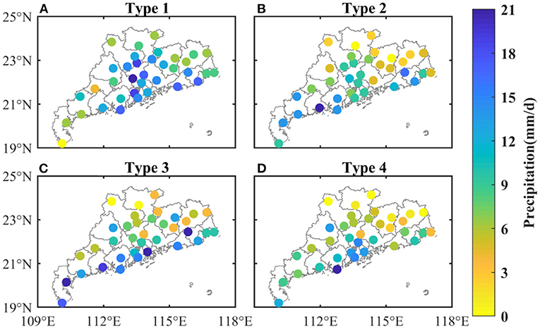
Figure 4. Spatial distribution of daily summer precipitation under four weather patterns: (A) Type 1, (B) Type 2, (C) Type 3, and (D) Type 4.
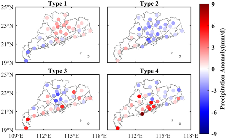
Figure 5. Spatial distribution of summer daily precipitation anomaly under four weather patterns relative to summer mean values: (A) Type 1, (B) Type 2, (C) Type 3, and (D) Type 4.
Factors Driving the Distribution of Precipitation Under Different Weather Patterns
Table 2 and Supplementary Table 2 shows the correlation coefficients and covariance between the monthly frequency of the four weather types and the monthly frequency of different precipitation classes. The more frequent the occurrence of Type 1, the less frequent the occurrence of moderate rain, heavy rain and torrential rain (with a confidence level of 0.01); the more frequent the occurrence of Type 2, the more frequent the occurrence of light rain (with a confidence level of 0.05); the more frequent the occurrence of Type 3, the more frequent the occurrence of heavy rain (with a confidence level of 0.01); and the more frequent the occurrence of Type 4, the less frequent the occurrence of light rain (with a confidence level of 0.01). The summer precipitation is regulated by the trend of the frequency of different weather types: the more frequent the occurrence of Type 1 and Type 2, the less summer precipitation; and the more frequent the occurrence of Type 3 and Type 4, the more summer precipitation.

Table 2. Correlation coefficients between weather type frequency and precipitation class frequency, 2014–2018.
Water vapor and vertical upward motion can provide favorable conditions for precipitation formation (Li et al., 2021; Yang et al., 2021). Figures 6, 7 show water vapor flux anomaly, and water vapor flux divergence at 850 hPa in Guangdong, the water vapor flux can be referred to Supplementary Figure 2. Under Type 1, southwest wind brings water vapor to Guangdong. There is divergence of water vapor in eastern and northern Guangdong, which is consistent with more precipitation in the northeast of Guangdong. Under Type 2, more water vapor is transported to western Guangdong, which is consistent with more precipitation in western Guangdong. The Type 3 weather circulation is affected by the subtropical high pressure in the western Pacific. The high southwest wind brings abundant warm and humid air to Guangdong, and the water vapor flux is large. There is strong convergence in northern Guangdong, and strong divergence in eastern Guangdong, resulting favorable precipitation conditions. The southwestern water vapor flux of the Type 4 weather circulation is smaller in central and northern Guangdong, and stronger in western Guangdong. The spatial distribution of water vapor flux is similar to Type 3, but the overall convergence and divergence motion is smaller than Type 3.
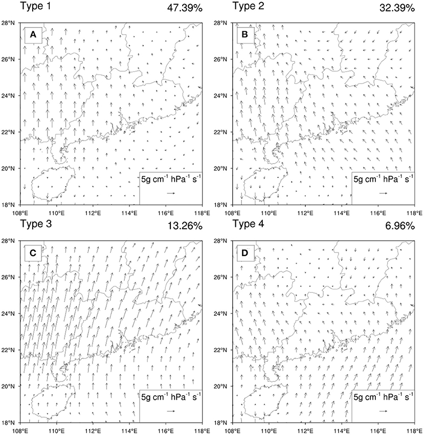
Figure 6. The anomalous water vapor flux at 850hPa for four weather types relative to summer mean values: (A) Type 1, (B) Type 2, (C) Type 3, and (D) Type 4.
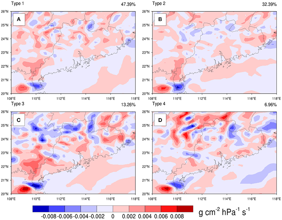
Figure 7. 850hPa water vapor flux divergence for four weather types: (A) Type 1, (B) Type 2, (C) Type 3, and (D) TYPE 4.
When sufficient water vapor is available, the condition of vertical motion determines the presence or absence and amount of precipitation. Vertical upward motion tends to trigger unstable energy, which can saturate unsaturated air and lead to water vapor condensation, then produce precipitation. This is one of the important factors in forecasting precipitation, especially for heavy rainfall. The vertical motion of the four weather types in the 700-hPa sea level pressure field is shown in Figure 8, the results reveal that: in Type 1, there is a small descending airflow of about 2 cm/s in the northern part of Guangdong Province, and an updraft in the central and southern areas; in Type 2, there is an updraft in the whole of Guangdong Province, a strong updraft in the PRD with a maximum updraft speed of about 3 cm/s, and a weak downdraft in the northern part and in Zhanjiang and Xuwen in Type 3, there is a strong convective center with a maximum upward motion speed of 4 cm/s over Guangxi. The southern China is dominated by a strong convective system, which impact on the precipitation in Guangdong Province. In Type 4, there is a strong updraft airflow with a maximum updraft speed of about 4 cm/s in PRD. The Northern and middle regions of Guangdong are mainly under the control of descending airflow, and the rest region is under the control of a more obvious updraft. In general, among the four weather types, the strong upward motion of the warm airflow located in the south of Guangdong Province and centered over the PRD causes the condensation of water vapor, which is always an important reason for frequent and strong precipitation in the PRD.
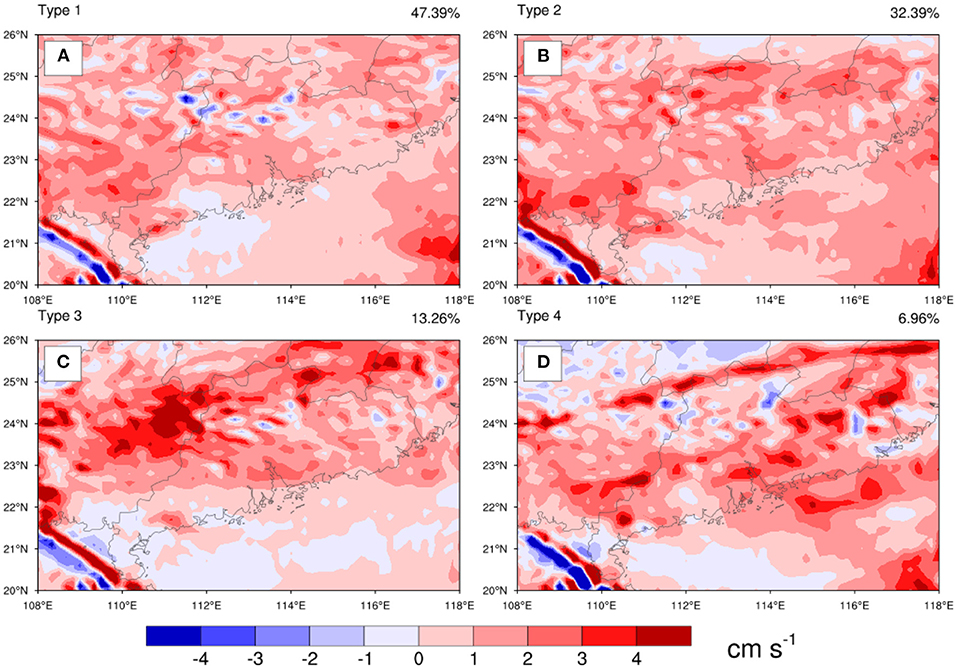
Figure 8. Vertical velocity at 700hPa for four weather types: (A) Type 1, (B) Type 2, (C) Type 3, and (D) Type 4.
Discussions
Previous studies show that urbanization makes more frequent and intense precipitation events in cities (Vittal et al., 2013; Donat et al., 2016; Li et al., 2020; Lijie et al., 2020). The impact of urbanization on precipitation in Guangdong cannot be ignored (Chen et al., 2021), but the impact of urbanization on precipitation under various weather types remains elusive.
To explore the urbanization effects, according to a station classification method (Yang et al., 2013; Li et al., 2015; Wanju et al., 2021), 24 stations were finally matched (Figure 1C). Both of Figures 9A,B show the decreasing trend of the frequency of each precipitation of the number of days of light rain and increasing trend of the number of days of moderate rain. The difference of light rain is obviously, which pass the ANOVA (Supplementary Table 1). To verify this trend, a long extension (1957–2015) of three stations (Guangzhou, Qingyuan, Guangning, Figure 1C), representing urban, suburban and rural, are chosen to statistic the trend of different classes of precipitation (Figure 10). Light rain in Guangzhou and Qingyuan has decreased significantly. Heavy rain in Guangzhou and Qingyuan has increased significantly. Rainstorm has increased significantly. The result is similar to Figure 9, that is, there were more obvious decrease of light rain and growth of heavy rain and rainstorm at urban station with respect to suburban and rural stations (the decrease and increase trends mentioned has passed Mann-Kendall test, with a confidence level of 0.05). Above Figure 11 illustrates a further zoning of Guangdong to investigate the effects of urbanization and weather patterns on precipitation. In general, more precipitation occurs in urban areas than that in rural areas. Figure 11 further show the daily precipitation for the four weather patterns urban and rural areas in northern, central, western and eastern Guangdong. Overall, the precipitation in urban areas is more than that in rural areas. According to the weather pattern, the difference between urban and rural areas of daily average precipitation is larger in Western and northern Guangdong in Type4, indicating that the Type 4 is greatly affected by urbanization in these two areas; The daily precipitation in rural in type 3 and type 4 is greater than that in cities in Western and eastern Guangdong, respectively. Table 1 shows that Type 1 and Type 2 have positive contribution for light rainfall; Type 3 and Type 4 have positive contribution for light rainfall for heavy rainfall and rainstorms. Therefore, the probability of weak rainfall in Guangdong is becoming smaller, while the probability of extreme rainstorms is becoming larger.
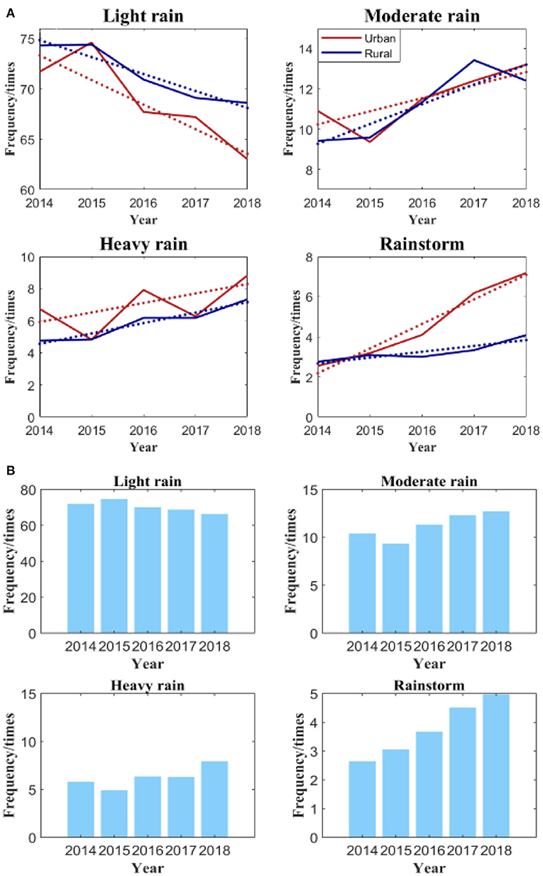
Figure 9. (A) Line (dashed lines indicate corresponding linear trends) and (B) Bar graphs of occurrence frequency of precipitation classes in Guangdong, 2014–2018.
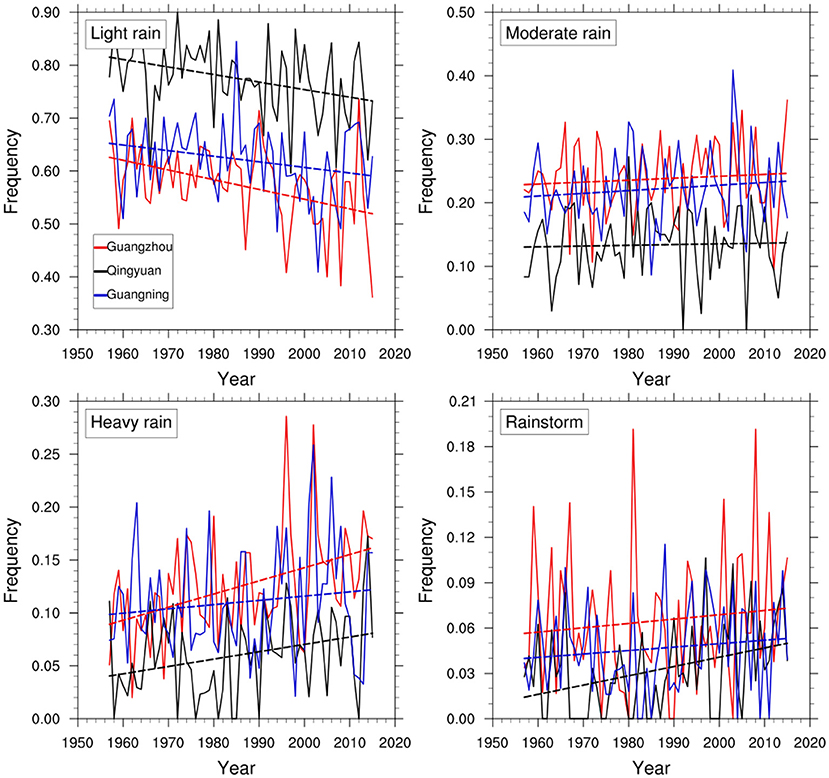
Figure 10. Line (dashed lines indicate corresponding linear trends) of occurrence frequency of precipitation classes in Guangzhou (red, urban station), Qingyuan (black, suburban station) and (blue, rural station), 1957–2015.
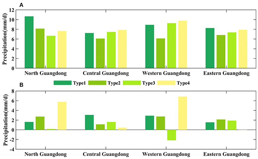
Figure 11. (A) Bar graphs of daily precipitation for the four weather patterns in northern, central, western and eastern Guangdong (B) Difference in daily precipitation between urban and rural areas under the four weather patterns in northern, central, western, and eastern Guangdong (precipitation difference = urban precipitation minus rural precipitation).
The above results show that in both urban and rural areas in Guangdong, there is a decrease in the frequency of light rainfall and an increase of heavy and torrential rainfall, which are mainly regulated by the frequency of different weather types (e.g., Type 1 and Type 2 are decreasing in frequency, while Type 3 and Type 4 are increasing in frequency). This is especially true in cities, which is consistent with the previous studies on precipitation changes in southern China (Zhang et al., 2005; Chuanbo and Li, 2014; Wu et al., 2019), and may be closely related to the effects of rapid urbanization.
Factors influencing urbanization leading to heavy precipitation are related to changes in subsurface types, anthropogenic heat emissions and increased aerosol concentrations in urban areas (Zhang et al., 2005; Ho et al., 2008; Chuanbo and Li, 2014; Su et al., 2019; Wu et al., 2019; Zheng et al., 2020). Urbanization has also changed the nature of the surface, with urban areas having an increasing number of high-rise buildings, especially in Guangdong, resulting in higher surface elevations. These high-rise buildings act to some extent as mountains in the natural topography, lifting the moist air transported to Guangdong Province by southerly and southwesterly winds from the ocean surface and enhancing the development of convection (Su et al., 2019). Meanwhile, the latent heat released by condensation during moisture uplift further enhances the convective system, leading to stronger precipitation. Chen et al. (2021) found that Guangdong Province, especially the PRD region, which is a mega-urban agglomeration bringing in anthropogenic heat has a stronger effective potential energy for convection than that in non-anthropogenic areas, and weaker convection suppression energy, creating a more unstable atmosphere where convection is more easily triggered. On the other hand, anthropogenic heat also affects the vertical distribution of humidity, as water vapor has a higher convergence and stronger vertical velocity at all levels in urban areas. In addition, aerosols in cities can influence precipitation by affecting cloud characteristics: usually light rain becomes weaker and heavy rain becomes stronger (Wang et al., 2011; Fu and Li, 2014). This two-sided effect depends mainly on the water vapor conditions over the city. When water vapor is insufficient, there are large amounts of aerosols over cities, cloud droplets decrease with aerosols, and the water-cloud of cloud droplets is more competitive, making the light rain falling to the urban surface is more lighter. Using datasets from multi-sensing satellites and global transport models, L'Ecuyer et al. (2009) found that aerosols suppress the precipitation process by redistributing water in more smaller clouds. Related studies also revealed that high concentrations of aerosols may not only lead to significant changes in cloud microphysical properties, resulting in smaller raindrops, but also to atmospheric warming, both of which can intensify the evaporation of raindrops and cause weak urban rainfall situations (Das and Chen, 2012). However, when water vapor is abundant, cloud-water competition is weak, cloud droplets increase with aerosols, condensation growth and cloud droplet collision effects are enhanced, and convective motion in clouds is strong, tending to increase the intensity of extreme rainfall (Fan et al., 2015; Ilotoviz et al., 2016; Taylor et al., 2016; Zheng et al., 2020). The combination of these factors leads to more intense precipitation and less light rain in the urban areas of the PRD than that in the rural areas.
Conclusion
In this study, the 850-hPa geopotential height were classified by using the T-PCA objective classification method based on the ERA5 reanalysis data. Combined with the daily precipitation observations from 36 meteorological stations in Guangdong Province from June to August each year from 2014 to 2018, the synoptic weather patterns of the summer precipitation in Guangdong Province were classified. This study revealed the urban–rural differences in summer precipitation in Guangdong and the modulating effects of the different weather types on precipitation and their urban–rural differences, with the following main conclusions:
Guangdong, South China, is mainly controlled by four weather types at the 850-hPa geopotential height. Among them, water vapor condensation caused by the strong upward motion of the warm airflow located in the south of Guangdong Province and centered over the PRD is always an important factor causing the precipitation in Guangdong Province. In addition, the subtropical high pressure system in the western Pacific Ocean significantly influences the summer precipitation in Guangdong Province, and the southwest airflow in front of the Indo-Burma trough provides abundant water vapor transport to the Bay of Bengal for the summer precipitation in Guangdong Province. Most of the stations with the highest daily precipitation are situated at coastal or island locations, and the maximum precipitation areas are all in the central region of Guangdong Province. The days of Type 1 (47.39%) and Type 2 (32.39%) weather patterns are steadily decreasing year by year and are dominated by light rain. The days of Type 3 (13.26%) and Type 4 (6.96%) weather patterns are steadily increasing and are dominated by heavy rainfall and above, indicating that the probability of light rainfall in Guangdong is becoming smaller and that of extreme rainstorms is becoming larger. The frequency of light rainfall is higher in rural areas than that in urban areas, and the frequency of moderate rainfall and over are higher in urban than that in rural areas. During 2014–2018, both urban and rural areas in Guangdong have a decreasing frequency of light rainfall and an increasing frequency of heavy and torrential rainfall, which is mainly due to the changing trend of the frequency of different weather types (e.g., Type 1 and Type 2 are decreasing and Type 3 and Type 4 are increasing). In addition, it was further found that the frequency of light rainfall decreases more significantly and the proportion of heavy and torrential rain increases more significantly in cities compared to that in rural areas, which is closely related to the effect of rapid urbanization.
The present study has explored the synergistic modulation effects of the weather circulation situation and urbanization on summer rainfall in Guangdong, South China, but there are still many uncertainties in the study of urbanization and the effects of weather types on precipitation in different district of Guangdong, which will need to be studied more thoroughly by using high-resolution refined meteorological station data in the future. Nevertheless, our findings will help to understand the possible mechanisms of global and regional climate change and the effect of anthropogenic activities on extreme rainfall, as well as provide theoretical support for predicting extreme precipitation events.
Data Availability Statement
The original contributions presented in the study are included in the article/Supplementary Material, further inquiries can be directed to the corresponding author/s.
Author Contributions
XB and YY: conceptualization, supervision, and funding acquisition. MZ, LZ, and YY: methodology. MZ, LZ, WL, and YZ: software. WL and ZL: validation. MZ, WL, XB, and YY: formal analysis. MZ and YY: writing—original draft preparation. WL, XB, and YY: writing—review and editing. MZ, WL, and YZ: visualization. All authors have read and agreed to the published version of the manuscript.
Funding
This study was jointly supported by the National Key Research and Development Program of China (2018YFC1507404) and the National Nature Science Foundation of China (42175098).
Conflict of Interest
The authors declare that the research was conducted in the absence of any commercial or financial relationships that could be construed as a potential conflict of interest.
Publisher's Note
All claims expressed in this article are solely those of the authors and do not necessarily represent those of their affiliated organizations, or those of the publisher, the editors and the reviewers. Any product that may be evaluated in this article, or claim that may be made by its manufacturer, is not guaranteed or endorsed by the publisher.
Supplementary Material
The Supplementary Material for this article can be found online at: https://www.frontiersin.org/articles/10.3389/fclim.2021.771772/full#supplementary-material
References
Chen, X., and Chen, Y. (1995). Development of Low-Level Jets during TAMEX. Month. Weath. Rev. 123, 1695–1719. doi: 10.1175/1520-0493(1995)123<1695:DOLLJD>2.0.CO;2
Chen, X., Zhang, H., Chen, W., and Huang, G. (2021). Urbanization and climate change impacts on future flood risk in the Pearl River Delta under shared socioeconomic pathways. Sci. Total Environ. 762:143144. doi: 10.1016/j.scitotenv.2020.143144
Chuanbo, F., and Li, D. (2014). Trends in the different grades of precipitation over South China during 1960–2010 and the possible link with anthropogenic aerosols. Adv. Atmosphere. Sci. 31, 480–491.
Cristiano, E., Veldhuis, M. C. T., and Giesen, N. (2017). Spatial and temporal variability of rainfall and their effects on hydrological response in urban areas—a review. Hydrol. Earth Syst. Sci. 21:7. doi: 10.5194/hess-21-3859-2017
Das, S. K., and Chen, J.-P. (2012). Investigation of aerosol effects on rain drop size distribution[C]/EGU General Assembly Conference Abstracts. 5078.
Donat, M. G., Lowry, A. L., Alexander, L. V., O'Gorman, P. A., and Maher, N. (2016). More extreme precipitation in the world's dry and wet regions. Nat. Clim. Chang. 6, 508–513. doi: 10.1038/nclimate2941
Fan, J., Rosenfeld, D., Yang, Y., Zhao, C., Leung, L. R., and Li, Z. (2015). Substantial contribution of anthropogenic air pollution to catastrophic floods in Southwest China. Geophysic. Res. Lett. 42:14. doi: 10.1002/2015GL064479
Fu, C., and Li, D. (2014). Trends in the Different Grades of Precipitation over South China during 1960-2010 and the possible link with Anthropogenic Aerosols. Adv. Atmos. Sci. 31, 480–491. doi: 10.1007/s00376-013-2102-7
Guo, C., Xiao, H., Yang, H., and Tang, Q. (2015). Observation and modeling analyses of the macro- and microphysical characteristics of a heavy rain storm in Beijing. Atmosphere. Res. 156, 125–141. doi: 10.1016/j.atmosres.2015.01.007
Ho, C.-H., Choi, Y.-S., Kim, J., Gong, D.-Y., and Park, R. J. (2008). The impact of aerosols on the summer rainfall frequency in China. J. Appl. Meteorol. Climatol. 47, 1802–1813. doi: 10.1175/2007JAMC1745.1
Holst, C. C., Tam, C. Y., and Chan, J. (2016). Sensitivity of urban rainfall to anthropogenic heat flux: a numerical experiment. Geophysic. Res. Lett. 43:7628. doi: 10.1002/2015GL067628
Hong, C., and Zhao, S. (2004). Heavy rainfalls in South China and related circulation during HUAMEX period. Chin. J. Atmosphere. Sci. 1:32–47. doi: 10.3878/j.issn.1006-9895.2004.01.04
Hu, C., Fung, K. Y., Tam, C. Y., and Wang, Z. (2021). Urbanization impacts on pearl river delta extreme rainfall sensitivity to land cover change versus anthropogenic heat. Earth Space Sci. 8:1536. doi: 10.1029/2020EA001536
Huth, R. (1996). An intercomparison of computer-assisted circulation classification methods. Int. J. Climatol. 16:8. doi: 10.1002/(SICI)1097-0088(199608)16:8<893::AID-JOC51>3.0.CO;2-Q
Huth, R., Beck, C., Philipp, A., Demuzere, M., Ustrnul, Z., Cahynova, M., et al. (2008). Classifications of atmospheric circulation patterns: recent advances and applications. Ann. N. Y. Acad. Sci. 1146, 105–152. doi: 10.1196/annals.1446.019
Ilotoviz, E., Khain, A. P., Be Nmoshe, N., Phillips, V., and Ryzhkov, A. V. (2016). Effect of Aerosols on freezing drops, hail, and precipitation in a midlatitude storm. J. Atmosphere. Sci. 73, 109–144. doi: 10.1175/JAS-D-14-0155.1
L'Ecuyer, T. S., Berg, W., Haynes, J., Lebsock, M., and Takemura, T. (2009). Global observations of aerosol impacts on precipitation occurrence in warm maritime clouds. J. Geophys. Res. 114:73. doi: 10.1029/2008JD011273
Li, W., Bi, X., Sheng, L., Luo, Y., and Sun, J. (2021). modulations of synoptic weather patterns on warm-sector heavy rainfall in South China: insights from high-density observations with principal component analysis. Front. Earth Sci. 9:678230.
Li, Y., Fowler, H. J., Argüeso, D., Blenkinsop, S., Evans, J. P., Lenderink, G., et al. (2020). Strong intensification of hourly rainfall extremes by urbanization. Geophysic. Res. Lett. 47:14. doi: 10.1029/2020GL088758
Li, Y.-B., Shi, T., Yang, Y.-J., Wu, B.-W., Wang, L.-B., Shi, C.-E., et al. (2015). Satellite-based investigation and evaluation of the observational environment of meteorological stations in Anhui Province, China. Pure Appl. Geophysic. 172:8. doi: 10.1007/s00024-014-1011-8
Lijie, L., Tao, G., Ming, L., Erjia, G., Yuanjian, Y., Zhen, L., et al. (2020). Contribution of urbanization to the changes in extreme climate events in urban agglomerations across China. Sci. Total Environ. 744:140624. doi: 10.1016/j.scitotenv.2020.140264
Liu, B., Chen, S., Tan, X., and Chen, X. (2021). Response of precipitation to extensive urbanization over the Pearl River Delta metropolitan region. Environ. Earth Sci. 80:3. doi: 10.1007/s12665-020-09299-3
Luo, Y. (2017). Advances in understanding the early-summer heavy rainfall over South China: research and forecast. Glob. Monsoon Syst. 913:17. doi: 10.1142/9789813200913_0017
Luo, Y., Zhang, R., Wan, Q., Wang, B., and Xiao, Y. (2016). The southern China monsoon rainfall experiment (SCMREX). Bull. Am. Meteorol. Soc. 98:5. doi: 10.1175/BAMS-D-15-00235.1
Ni, Y., Zhou, X., Zhang, R., Wang, P, and Yi, Q. (2006). Experiments and studies for heavy rainfall in Southern China. J. Appl. Meteor. Sci. 17, 690–704. Available online at: http://qikan.camscma.cn/en/article/id/200606118
Ning, G., Yim, S. H. L., Wang, S., Duan, B., Nie, C., Yang, X., et al. (2019). Synergistic effects of synoptic weather patterns and topography on air quality: a case of the Sichuan Basin of China. Clim. Dynam. 53, 6729–6744. doi: 10.1007/s00382-019-04954-3
Ning, G., Yim, S. H. L., Yang, Y., Gu, Y., and Dong, G. (2020). Modulations of synoptic and climatic changes on ozone pollution and its health risks in mountain-basin areas. Atmos. Environ. 240:117808. doi: 10.1016/j.atmosenv.2020.117808
Philipp, A., Beck, C., Esteban, P., Kreienkamp, F., and Streicher, F. (2014). COST733CLASS v1.2 User guide. Available online at: http://cost733.geo.uni-augsburg.de
Ramage, C. S. (1952). Variation of Rainfall Over South China Through the Wet Season. Bull. Am. Meteorol. Soc. 33, 308–311. doi: 10.1175/1520-0477-33.7.308
Su, L., Li, J., Shi, X., and Fung, J. C. H. (2019). Spatiotemporal variation in presummer precipitation over South China from 1979 to 2015 and its relationship with urbanization. J. Geophysic. Res. Atmosphere. 124:13. doi: 10.1029/2019JD030751
Taylor, J. W., Choularton, T. W., Blyth, A. M., Flynn, M. J., Williams, P. I., Young, G., et al. (2016). Aerosol measurements during COPE: composition, size and sources of CCN and INPs at the interface between marine and terrestrial influences. Atmosphere. Chem. Physic. 16, 1–39. doi: 10.5194/acp-16-11687-2016
Vittal, H., Karmakar, S., and Ghosh, S. (2013). Diametric changes in trends and patterns of extreme rainfall over India from pre-1950 to post-1950. Geophys. Res. Lett. 40, 3253–3258. doi: 10.1002/grl.50631
Wang, F., Ge, Q., Wang, S., Li, Q., and Jones, P. D. (2015a). A new estimation of urbanization's contribution to the warming trend in China. J. Clim. 28:150804114817003. doi: 10.1175/JCLI-D-14-00427.1
Wang, F., Wu, Y. H., Yang, H., Tanida, Y., and Kamei, A. (2015b). Preliminary investigation of the 20 August 2014 debris flows triggered by a severe rainstorm in Hiroshima City, Japan. Geoenviron. Disast. 2:17. doi: 10.1186/s40677-015-0025-6
Wang, J., Feng, J., and Yan, Z. (2015c). Potential sensitivity of warm season precipitation to urbanization extents: modeling study in Beijing-Tianjin-Hebei urban agglomeration in China. J. Geophysic. Res. Atmosph. 120:18. doi: 10.1002/2015JD023572
Wang, S., Jiang, F., and Ding, Y. (2015d). Spatial coherence of variations in seasonal extreme precipitation events over Northwest Arid Region, China. Int. J. Climatol. 35:15. doi: 10.1002/joc.4313
Wang, Y., Wan, Q., Meng, W., Liao, F., Tan, H., and Zhang, R. (2011). Impacts of aerosols on weather and regional climate over the Pearl River Delta megacity area in China. Atmosphere. Chemistr. 11, 23275–23316. doi: 10.5194/acpd-11-23275-2011
Wanju, L., Xueyan, B., Lifang, S., Yali, L., and Jianhua, S. (2021). Modulations of synoptic weather patterns on warm-sector heavy rainfall in South China: insights from high-density observations with principal component analysis. Front. Earth Sci. 9:320. doi: 10.3389/feart.2021.678230
Wu, M., Luo, Y., Chen, F., and Wong, W. K. (2019). Observed link of extreme hourly precipitation changes to urbanization over coastal South China. J. Appl. Meteorol. Climatol. 58:8 doi: 10.1175/JAMC-D-18-0284.1
Yali, L., Mengwen, W., Fumin, R., Jian, L., and WaiKin, W. (2016). Synoptic situations of extreme hourly precipitation over China. J. Clim. 29:24. doi: 10.1175/JCLI-D-16-0057.1
Yan, M., Chan, J. C. L., and Zhao, K. (2020). Impacts of urbanization on the precipitation characteristics in Guangdong Province, China. Adv. Atmosphere. Sci. 37, 696–706. doi: 10.1007/s00376-020-9218-3
Yang, Y., Wang, R., Chen, F., Liu, C., Bi, X., and Huang, M. (2021). Synoptic weather patterns modulate the frequency, type and vertical structure of summer precipitation over Eastern China: a perspective from GPM observations. Atmosphere. Res. 249:105342. doi: 10.1016/j.atmosres.2020.105342
Yang, Y.-J., Wu, B.-W., Shi, C.-,e., Zhang, J.-H., Li, Y.-B., Tang, W.-A., et al. (2013). Impacts of urbanization and station-relocation on surface air temperature series in Anhui Province, China. Pure Appl. Geophysic. 170:11. doi: 10.1007/s00024-012-0619-9
Zhang, J., Lohmann, U., Cheng, Y., Luo, Y., Liu, Z., and Lesins, G. (2005). Contribution of changes in sea surface temperature and aerosol loading to the decreasing precipitation trend in Southern China. J. Clim. 18, 1381–1390. doi: 10.1175/JCLI3341.1
Zheng, Y., Xue, M., Li, B., Chen, J., and Tao, Z. (2016). Spatial characteristics of extreme rainfall over China with hourly through 24-h accumulation periods based on national-level hourly rain gauge data. Adv. Atmosphere. Sci. 33, 1218–1232. doi: 10.1007/s00376-016-6128-5
Keywords: synoptic weather patterns, urbanization, summer precipitation, Principal Component Analysis, South China
Citation: Zhang M, Li W, Bi X, Zong L, Zhang Y and Yang Y (2021) Synergistic Modulations of Large-Scale Synoptic Patterns and Local-Scale Urbanization Effects on Summer Rainfall in South China. Front. Clim. 3:771772. doi: 10.3389/fclim.2021.771772
Received: 07 September 2021; Accepted: 22 November 2021;
Published: 13 December 2021.
Edited by:
Celso Von Randow, National Institute of Space Research (INPE), BrazilReviewed by:
Guicai Ning, The Chinese University of Hong Kong, Hong Kong SAR, ChinaChristopher Alexander Cunningham, Center for Monitoring and Early Warning of Natural Disaster, Brazil
Copyright © 2021 Zhang, Li, Bi, Zong, Zhang and Yang. This is an open-access article distributed under the terms of the Creative Commons Attribution License (CC BY). The use, distribution or reproduction in other forums is permitted, provided the original author(s) and the copyright owner(s) are credited and that the original publication in this journal is cited, in accordance with accepted academic practice. No use, distribution or reproduction is permitted which does not comply with these terms.
*Correspondence: Xueyan Bi, eHliaUBnZDEyMS5jbg==
† These authors have contributed equally to this work
 Minxuan Zhang
 Wanju Li
 Xueyan Bi
 Lian Zong1
 Yuanjian Yang