 Tefera Beyera Bayuma
94% of researchers rate our articles as excellent or good
Learn more about the work of our research integrity team to safeguard the quality of each article we publish.
Find out more
ORIGINAL RESEARCH article
Front. Built Environ. , 21 March 2025
Sec. Urban Science
Volume 11 - 2025 | https://doi.org/10.3389/fbuil.2025.1540079
Conformity with land-use planning in a city is problematic in informal settlement areas and requires the interpretation of the reasons for informal land use. This study aimed to evaluate the spatial impact of informal land use on planning, determine the extent to which such informal land use conforms with land-use plans, and the reasons for this. This study applied a case study with both a qualitative and quantitative research approach in which the quantitative spatial data in this study were explained and contextualized by qualitative data. Primary data were collected by interviews with eight informal settlers and twelve experts. The secondary data included are the proposed land-use map and the city’s parcel-based informal land-use inventory types. The findings revealed that 81% of informal houses occupied parcels of land larger than 140 m2 due to demand for larger plot sizes. This led to a shortage of space for service provision. This study also found that 69.10% of informal land-use types adhered to the land-use plans. This is due to the administrator’s conscious decision to include informal land use into the city’s structural plan and the deliberate efforts of informal settlers to be part of the structural plan by obtaining information from city planners. This implies that the behavior of government and individual actors can lead informal land-use types to conform with the adopted plan.
One of the most remarkable characteristics of human settlement in the 21st century has been rapid urbanization, as reflected in the increased population of urban areas compared to rural areas, particularly in Asia and Africa (The World Bank, 2017; UN-Habitat, 2016). Urban expansion has resulted in the transformation of agricultural land, previously owned and utilized by rural villages, for residential or commercial purposes (Asamoah, 2010; Teck-Hong, 2012; Cobbinah and Erdiaw-Kwasie, 2018; Peerzado et al., 2019). Approximately 56.2% of the world’s population lives in urban areas (UNDESA, 2018; Koroso, 2022). Urban agglomeration offers advantages such as a large labor pool, greater access to local markets, reduced transaction and information costs, and the creation of more diverse social networks contacts (United Nations Economic Commission for Africa, 2008; Robinson et al., 2012).
Managing urbanization, especially the use of urban land to facilitate the development of emerging cities as drivers of development, poses a significant problem in numerous Sub-Saharan African nations. Africa’s urbanization has occurred without industrialization (Gollin et al., 2016; Goodfellow, 2017) and has not been well managed, causing land-use problems such as the upsurge of slums and informal settlements (Mutiara, 2008; Matamanda et al., 2021).
Informal settlements in developing countries constitute a significant proportion of urban areas and are home to large populations (Dubovyk et al., 2010; Gouverneur, 2014; Durovic and Nikolic, 2016; Nduwayezu et al., 2017). This is due to a significant proportion of rural land being used for housing and industrial purposes through informal methods (Tang and Chung, 2002). In developing countries, approximately one-third of the urban population lives in informal settlements (UN-Habitat, 2015; Obermayr, 2017). If current trends continue, the number of people residing in informal settlements is expected to rise from two to three billion by 2050 (Okyere et al., 2016; United Nations Human Settlements Programme, 2010). In African cities, it is estimated that 61.7% of urban residents reside in informal housing areas, which significantly contributes to urban development and poses many challenges (UN-Habitat, 2015). Due to the rapid growth of informal settlements in the Global South, people’s living conditions in such areas are subject to inadequate and deteriorating living conditions. To address these problems, international health agendas emphasize the need for inter-sector action (Weimann et al., 2020). The solving of informal settlement problems in Africa has not been not properly recognized in the formulation of policy (Roberts et al., 2012). There is a deficiency of inclusive strategies for integrating informal settlements into urban planning and governance systems (Mohamed et al., 2020).
Informal settlement is society’s spontaneous reaction to inadequate land administration. Informal settlement is a pragmatic approach that starts from the bottom up and involves deviating from adherence to formal land planning based on practical needs (Chiodelli and Moroni, 2014). In developing countries, however, the realities of informal urban settlements vary across the economic, spatial, and political fields. New ideas are now emerging that recognize the diversity of informality across contexts and dimensions as well as its everyday lived realities (Banks et al., 2020).
While studies in this field often focus on the impacts of informal settlement on socio-economics, and governance (Hantalo and Dube, 2023), and the reasons for the non-conformity of informal settlements with the structural plan of cities (Iban, 2020), further research is still required on the spatial effects and reasons for the conformity of informal settlements with adopted structural plans (Mabaso et al., 2015; Bulti and Sori, 2017; Menzori et al., 2021). It seems that little attention has been paid to assessing the impacts of informal land use on land-use planning and interpreting why informal land use does conform with adopted land use plans. Despite the importance of such assessment for regulating and managing informal land development and taking necessary action, there is a lack of quantitative empirical assessment of the impact of informal land use on urban land-use plans. Moreover, researchers have not assessed or interpreted the degree to which informal residential land use practices conform to plans.
The conformity of informal residential land use is a product of decisions made by land-use actors and influences urban land-use development (Shen et al., 2019). Previous research has examined the reasons for the non-conformity of informal development, which is attributed to factors such as weak government law enforcement on planning implementation and the manipulation of rules by informal actors (Shen et al., 2019). However, no studies have tried to interpret the conformity of informal residential land use from the viewpoint of actors’ decision-making behavior.
Therefore, this study addressed three questions. (1) What are the spatial impacts of informal residential land use on the urban land use plan of a city? (2) To what extent does informal residential land use conform to adopted plans? (3) What are the reasons for informal residential land use conforming with an adopted plan?
Informal settlement lacks a universally accepted definition (Gilbert, 2011; Pfeffer, 2011) and so has different meanings in various countries. However, “informal settlements” are commonly defined as built-up areas where residents commonly have no guarantee of ownership for the buildings or land they occupy; they may be squatting or renting informally. Such settlements typically lack common services and urban infrastructure. Additionally, the houses in these settlements do not adhere to planning rules and are usually located in geographically hazardous areas (UN-Habitat, 2015).
In Ethiopia, informal settlements are where houses are constructed on community or government land without legal right to the land and/or building permission (Ambaye, 2011). Ethiopia’s Ministry of Urban Development (2015) defines “informal settlement” as an area that is squatted without permission from the government and where the buildings do not adhere to the City planning guidelines. Such informal illegitimate settlements are commonly referred to as “moonshine houses,” with individuals occupying the land during the night (Daniel, 2006).
The planning literature offers two types of approaches for appraising the implementation of urban plans: conformity- and performance-based (Laurian et al., 2004; Hossu et al., 2021). Both are based on differing assumptions about the purpose of planning. The conformity approach addresses the outcomes of planning and the connections between actual developments and plans (Laurian et al., 2004; Berke et al., 2006; Alfasi et al., 2012; Padeiro, 2016). According to this approach, a plan is implemented when the development patterns conform with its guidelines and achieve its goals (Laurian et al., 2004). This method takes a rational planning model in which plans serve as roadmap for upcoming development. It adopts a direct relationship between the objectives of a plan and its results (Wildavsky, 1973).
Moreover, a conformity approach assumes that the strategy/policies in the plan are sufficiently detailed to guide development and that the extent to which development activities comply or deviate can be evaluated either quantitatively or qualitatively. The well-developed literature and abundant discussion on selecting and utilizing indicators to screen plans and policies imply a result-oriented perspective on planning and policymaking (Laurian et al., 2004). This perspective also considers that plans must serve as templates for development.
In contrast, the performance-based method emphasizes planning procedures and uses plans as a reference for upcoming planning decisions making rather than as a roadmap (Faludi, 2000; Hopkins, 2001; Albrechts, 2006). This method holds that a plan is considered effective when stakeholders are involved in decision-making processes, (Laurian et al., 2004). This method considers that planning practice is adaptive and must be modified to constantly changing conditions—plans do not have to necessarily stick to the original. Thus, when deviations from an adopted plan are rational or compulsory, the plan can still be considered effective, even though the planning decisions deviate from its guidelines. This method is easy to use when there are regular monitoring activities. However, in most cases, there are difficulties in measuring a plan’s performance due to a lack of monitoring (Feitelson et al., 2017).
In summary, a conformity-based approach emphasizes the connection between plans and results. Conformity assessment is measurable, easy to use, and can indicate the level of plan operation (Shen et al., 2019; Shen et al., 2021). In contrast, a performance-based approach stresses the planning procedure and the cultural significance of the plan. The benefits of a conformity-based approach include precision when relating the plan and its outcomes and is more applicable to practitioners (Laurian et al., 2004).
In this paper, a conformity-based method was applied to evaluate the conformity of informal residential land use to the adopted plan. This method provides both qualitative and quantitative measurements, allows a comparison of the land-use plans approved by Burayu in 2014 with the physical outcomes of the informal settlement development patterns. Furthermore, the conformity method attempts to identify mismatches between the planned land use for a specific period and the actual informal residential land use.
This research was carried out in Burayu City, 15 km from Addis Ababa, the capital city of Ethiopia. Geographically, the city extends from 9° 01′00″ to 9° 06′00″N latitude and 38° 36′00″ to 38° 42′00″E longitude. Burayu belongs to the Oromia Special Zone bordering Addis Ababa. The location map of the city is depicted in Figure 1.

Figure 1. Location map of the study area.
Burayu was chosen for this study because 54% of the houses were informal (Bekele et al., 2014). This demonstrates the prevalence of informal settlements compared to neighboring Addis Ababa, and it has high potential for future growth due to its proximity to the country’s capital (Dejene, 2014). For instance, in 2019, the Oromia land use administration found that the size of informal plots in Burayu City was larger than that of other special zone cities in Oromia (Figure 2).
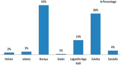
Figure 2. Informal settlers in Oromia Special Zone cities around Addis Ababa.
Burayu is one of the fastest growing cities in Ethiopia, both in population and area. The city’s population in 2017, including informal settlers, was 280,000, with an annual growth rate of 15.5% (Dejene, 2014). Nevertheless, Burayu’s population had increased to 400,000 in 2022 according to data obtained from the city’s finance and development office. Its spatial growth has been rapid. For example, Burayu covered a total area of 90.57 km2 in 2014 (OIUP, 2014), but according to land inventory made by city administration in 2018, the total area of the city was 9,129,156.23 m2.
The city of Burayu is undergoing a significant transformation in land use, shifting from farm fields to built-up areas. This change was driven by rapid population growth, which in turn created a need for land for housing construction and other purposes. Farmland around Burayu City is owned by farmers who are engaged in agriculture. However, it appears that numerous farmers and other agricultural landowners have illegally divided their land into small sections and sold it to buyers.
The formal land use plan of Burayu is divided into seven categories (Figure 3): residential; administrative; business and commercial; manufacturing and industrial; open space, green areas, and environmentally sensitive areas; services; infrastructure, utilities, and transportation. On the other hand, there are four informal land-use types (Figure 4). The next section presents the overall methodology utilized to address the research questions.
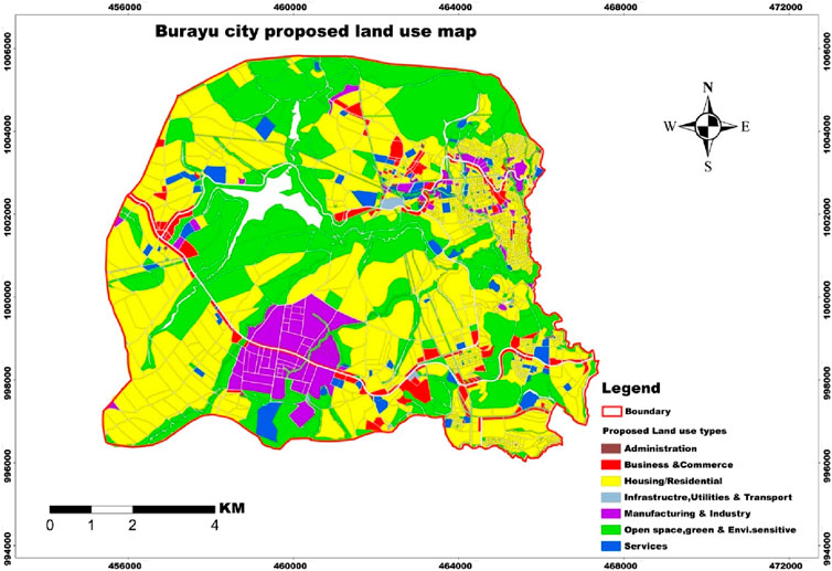
Figure 3. Burayu City proposed land use map (2014–2024).
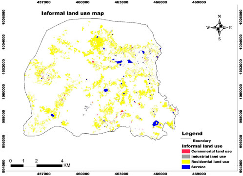
Figure 4. Burayu City informal land use type map (2018).
This study utilized a case study research design with a combination of quantitative and qualitative research approaches; these were assumed as appropriate as a strategy for this study. The analysis of informal settlement impact, conformity, and its interpretation is a complex and dynamic process that necessitates thorough comprehension of the local situation and a detailed explanation and interpretation of the issue under investigation (Yin, 2009). A mix of qualitative and quantitative approaches allows researchers to gather data from various sources, including documents, questionnaires and interviews (Zucker, 2009; Yin, 2014). A case study and mixed approach provide exclusive methodological benefits for scholars seeking to resolve the complexity of these research challenges and questions (Ivankova and Plano Clark, 2018). A case study and mixed approach are not distinct units—rather, the boundary between them is porous and fluid, letting each support the other (Carolan et al., 2016).
Based on a case study and mixed approach research design, an amalgamation of descriptive and explanatory research types was used in this study (Yin, 2003; Mensah, 2014). The descriptive research type provides a detailed description of an issue within its actual situation (Hancock and Algozzine, 2006), while the explanatory case study is used to explain the causes of an issue with the ultimate objective of defining how events occur and which may affect particular outcomes. Therefore, a sequential mixed research design was used in this study for spatial data collection and then followed by qualitative data collection and analysis. Qualitative data were used to explain and contextualize spatial results.
In order for spatial sampling to analyze the impact and conformity of informal residential land use, we extracted the total area of 13,753,148 m2 residential land use from the city’s proposed land use type (20,718,807 m2). We also extracted 8,747,807.33 m2 informal residential plots from the total area occupied by informal land use (9,619,629.33 m2).
For non-spatial sampling, the respondents for the interviews were selected by purposive sampling. Residents/informal settlers who had lived in Burayu for at least 5 years were selected. Similarly, experts with at least 5 years working experience in the city’s planning and land administration were selected. Based on these criteria, 12 out of 45 experts in the Burayu City land administration were selected. Moreover, in the city, from each of the eight informal settlement spots, one informal settler was selected based on 5 years of residence to ensure the provision of rich information about large plots and the conformity of informal land use with the adopted plan. It was assumed that residents who had lived in an area for a long time and professionals working in the city administration for a long period could better able identify the reasons for occupying large plots of land and interpret the conformity of informal residential land use with the adopted land use plan.
Although informal settlers in informal settlement areas are considered unlawful, they desire greater social recognition. Therefore, it is not difficult to classify themselves as informal residents. A total of eight informal settlers and twelve experts with different professional backgrounds (three planners, two surveyors, four land administrators, and three legal experts) were involved in the interviews conducted by the city’s land use administration.
The data used in this study came from secondary and primary sources. Secondary sources included spatial data such as proposed land use, informal residential land, and the boundaries of the city. In addition, the contents of Ethiopia’s structure plan preparation and implementation policies were analytically reviewed to classify the urban center category and then to identify the standard size of plots for residential land use. The secondary data used for the spatial analysis obtained from different sources are presented in Table 1.
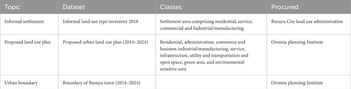
Table 1. An overview of the spatial data and selected classes used in the analysis.
Even though there are many informal buildings in the study area, including residential, service, commercial, and industrial/manufacturing land use, for the purposes of this study, residential land use type was used for impact and conformity analysis because, in most cases, “informal settlement” refers to residential land use types. Thus, the informal land use type inventory conducted 2015–2018 by the city administration, exists in a shape file, from which informal land use was extracted. Then, the coordinates of the shape file were redefined and transformed into the projected Ethiopian coordinate system (WGS 1984 UTM Zone 37N).
The issues of occupying large areas and the reasons for the conformity of informal land use go beyond spatial data analysis. Therefore, these data were collected through interviews with Burayu’s land use administration experts and informal settlers.
As informal land occupation is illegal and can lead to suspicion, the objective of the research was explained to participants before interviews to avoid any potential problems. Consequently, the interviews were conducted with great care to address the objective of the investigation and to ensure the confidentiality of their answers. The responses were collected by visiting various informal settlement areas in the town. Questionnaires were administered in either Afan Oromo or Amharic, depending on the participants’ preferred local language. Trained data collectors recorded their responses. The interviews were conducted for 20–30 min, with an average duration of 25 min. Data were collected from 30 January to 28 February 2021.
To analyze the impacts of informal residential use in urban land use planning, discrepancies between the established standards (140 m2 plot of land allocated) and actual informal residential land use were analyzed. Based on this standard, informal residential land use was divided into three categories: greater than, equal to, and less than 140 m2 plots of land. On the other hand, the conformity of informal residential land use with the adopted plan was analyzed by investigating the spatial consistencies and inconsistencies between urban residential land plan and residential informal land use by intersect and dissolve tools. ArcMap 10.7.1 software was used to process the data. The interpretation of the conformity was based on the following criteria. Conformity occurs when the land occupied by informal residential land use in 2018 aligns with the proposed land residential use plan for 2018. Non-conformity occurs when the informal residential land use in 2018 deviates from the proposed residential land use plan in 2018.
The data obtained through interviews were analyzed and presented using narrative. Then, the narrated data aimed to explain spatial data. Thus, the spatial findings were explained by non-spatial (narrated data) to illustrate why residents strove to occupy large plot sizes and the reasons for the conformity of informal land use with the adopted land use plan.
See Figure 5 for the overall methodology used to address the objective.
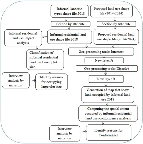
Figure 5. Methodological flow chart.
To evaluate the impact of informal settlements on the land-use plan, it is crucial to determine the urban center category as this has implications for the distribution of plot sizes. Urban centers in Ethiopia are grouped into five categories according to population: small city (2,000–20,000), medium city (20,001–50,000), large city (50,001–100,000), city (100,001–1,000,000), and metropolis (over 1 million) (MUDC, 2012; Admasu and Jenberu, 2020). Based on this standard Buryau is belong to city. For urban land use issues in Ethiopia, the Ministry of Urban Development and Construction (MUDC, 2012) has set standards for the minimum and maximum proportions of major land use in various urban categories within Ethiopia. However, the average residential plot size area is based on the corresponding regional government state policy and housing typology (MUDC, 2012). In line with this policy and the housing typology, Oromia regional state enacted Regulation 15/2016 limiting the standard size of plots for residential land use to 140 m2 for the city. This regulation also applies to Burayu.
This study attempts to evaluate land-use practices in Burayu City in accordance with Oromia regional state regulation No.15/2016. In contrast to what is stipulated there, 85% of informal residential land uses occupies less than and greater than 140 m2 informal residential land use types, which does not match with the regulatory standards (Figure 6). As depicted in Figure 6, a significant percentage of the land occupied by informal residential settlements exceeds 140 m2.
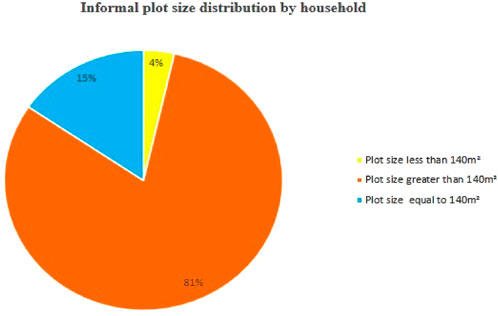
Figure 6. Percentage of plot size distribution by household against set standard.
This finding demonstrates the existence of discrepancies between the established standard and actual practice. In other words, informal residential land use plots largely exceed the planning standards set by the region’s land use regulations. This can be explained as follows. Approximately 23,902 residential houses were constructed on an informal land area of 6,472,608.60 m2. However, if that had been formally planned for the same number of households, a land area of 3,346,420 m2 would have been sufficient. Thus, the difference becomes 3,126,188 m2. This indicates that the city administration can provide this difference for 22,331 households, based on the established standard.
The interview with the informal settlers revealed that Burayu residents prefer a land plot of more than 140 m2. This is because they lack the capital to construct high-rise buildings, and they want to preserve the same plot in case regularization can be executed by the government, as the road in front of their house is too narrow. Moreover, interviews conducted with professionals in the land use office revealed that land speculators in informal settlement areas prefer larger parcel sizes because they have a higher purchasing power and they earn more money from large plots of land than from small ones.
In contrast, experts revealed that economically deprived persons residing in informal settlement areas reside in dwellings smaller than 140 m2. This is mainly because of their limited purchasing power. In general, the results show that the demand for larger sites drives informal residential growth in the study area. This has led to disregard for urban land use plan standards and the inefficient use of urban land, make provision of service space difficult, increasing land-use conflicts, and uncontrolled land use changing the city’s development.
The data obtained from the city administration indicates that the land occupied by informal land-use types can be grouped into four categories: residential, commercial, services, and manufacturing. However, this study used informal residential land-use types to assess their adherence and deviation from the proposed residential land use in the city.
From the city’s total proposed land use area, the total area of the proposed residential land use is 13,753,148 m2, while the total area occupied by informal residential areas is 8,747,807.33 m2, including both conforming and non-conforming. Informal residential land use thus accounts for 63.60% of the total land used for residential land use. Figure 7 displays the distribution of informal residential land use compared to the proposed land-use type of Burayu.
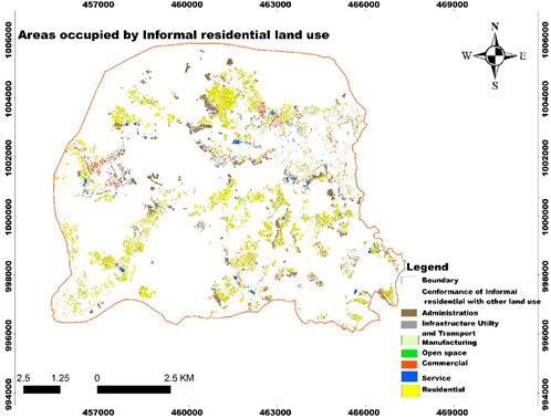
Figure 7. Informal residential area occupying the proposed land use in the study area.
As shown in Table 2, 69.10% of the proposed residential land use is occupied by informal residential land use, indicating that a significant proportion of informal residential land use is consistent with the proposed residential land use. On the other hand, 38.9% of informal residential land use was found to occupy land planned for other uses. This indicates the non-conformity of informal residential land use with the adopted residential land use plan.
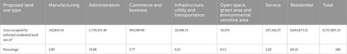
Table 2. Extent of informal residential land use conformity and non-conformity with proposed residential land use plan.
To determine the reasons for the compliance of informal residential land use with the proposed residential land use plan, interviews were conducted. The informal settlers pointed out that when deciding to purchase land from farmers, they gathered information from experts in land-use administration and from land brokers regarding the conformity of land use. They generally preferred to live in or purchase properties in residential areas that adhere to the adopted land use plan.
According to planners in land administration, most of the informal residential areas were built before the rural–urban land transition, meaning some informal housing was built or developed before an area was planned—before land use plans were created and approved. To avoid displacing large numbers of residents, the current structural plan was prepared to strongly focus on the existing conditions on the ground. This means that the Oromia planning institution, in collaboration with Barayu land administration, conducted a land-use survey and identified land for residential land use based on what was happening on the ground by involving some informal settlers in the process. The adopted plan was harmonized with the existing informal residential buildings, even though these types of housing were considered informal. The experts added that some informal settlers were encroaching on areas formally reserved for housing, which also a contributing factor to the conformity of the land use. This shows that some informal residential land uses comply with the proposed land-use plan due to encroachment into formally planned areas.
The aim of this study is to assess the impact of informal land use and its conformity with the proposed urban land use and to evaluate conformity with the urban land-use plan. Therefore, this study concentrated on the relationship between informal and planned residential land use. This discussion section is organized around two related themes: the impact of informal residential settlement on land use and the conformity of this with the proposed residential land use, focusing on the interpretation of conformity.
Land-use conformity refers to the extent to which land uses comply with local zoning regulations and other land-use policies (Padeiro, 2016). Informal settlement areas are residential areas that are not recognized by the government or have not been planned or developed according to formal standards (Mohanty, 2020). Conformity-based studies in informal settlement areas are not common; however, many researchers have utilized the conformity approach to determine land-use planning and physical outcomes in planning areas (Han, 2014; Qiwei et al., 2015; Bulti and Sori, 2017).
This study showed that a large percentage (81%) of informal residential settlements was built on plots land larger than 140 m2 (Figure 6) due to high demand for larger land plot sizes. This is the cause of disregard of urban land-use plan standards and the ineffective use of urban land. With regard to the influence of informal settlement on urban land use plans, the impacts of informal settlements are not only restricted to issues of tenure insecurity and ownership but also contribute to an increase in violations against land use plans (Chen et al., 2016; Koroso et al., 2020; Fouad and Abbas, 2021).
The conformity of informal residential land-use plans was measured by comparing informal residential land use with proposed urban land use. The results (Table 2) demonstrate a 69.10% conformity of informal residential land use with proposed land use. Although other studies define informal settlements in urban areas as areas where buildings do not conform to planning regulations (Mensah et al., 2013; Okyere and Kita, 2015; Alzamil, 2018), this study found that a large percentage of informal residential buildings conform to the proposed land use; hence, this is important in preventing the demolition of informal settlements which conform with adopted plans. This study highlights the importance of a people-centered approach that should encourage the integration of informal settlements into the development areas of peri-urban settlements in developing countries rather than focusing on demolition. The inclusion of informal settlement in city planning promotes the inclusion of residents in urban development. Boyacıoğlu et al. (2023) proposed that people-centered approach should be integrated into policies for the development areas of settlements.
Therefore, based on this analysis, informal land use types do not necessarily equate with non-conformity in Burayu City. This necessitates investigating the reasons behind this conformity. A study of a Norwegian municipality showed that 96%–98% of it was in accordance with the city’s master plan (Saglie and Sandberg, 1997) due to the popular legitimacy in adopting the land-use plan through the active participation of residents. This increased conformity with the plan’s implementation. However, the conformity of informal land use with the adopted plan in Burayu is due to the municipality’s conscious decision to incorporate unplanned rural /informal housing in the newly developed land use plan. Another cause is that the informal settlers have used the existing land use plan as a basis for their settlement decisions.
This paper assessed the spatial impact of informal settlement on Burayu City’s land use planning and the degree of conformity of informal land use with adopted plans and the reasons for this. The study used a conformity approach which utilized GIS to compute an informal plot size occupation against the permitted standards and the spatial extent of the proposed land use occupied by informal residential land uses.
The majority of informal land use in the study area had plot sizes larger than the set standard, showing an inefficient use of land and a rapid horizontal and unplanned expansion of the built-up area. Thus, controlling the expansion of informal settlement not only solves the problem of informality but is also a method of containing the horizontal development of the city into rural areas.
A large percentage of informal land-use practices conformed with formal land-use planning in the study area due to the behavior of government and individual actors in dealing with informal land use types. This implies that in dealing with informal land use, instead of using demotion as a strategy, future planning policy should focus on site development and retrofitting infrastructure based on compliance with prescribed plot sizes. Such an approach would not only prevent property destruction but also foster a stronger sense of community and established social fabric continuity.
The causes of informal land use conforming with land use planning are puzzling in the study areas. This indicates that the realities of urban informality vary across the economic, spatial, and political realms in developing countries. Therefore, recognizing the diversity of informality across contexts and dimensions as well as its everyday lived realities are very important for adopting suitable strategies for informal settlement expansion.
In view of these findings, it is recommended that policies for the upgrading of informal settlements in Burayu City should focus on integrating informal settlers and a people-centered approach by regularization. This can be done by involving local communities and stakeholders in the decision-making process and tailoring the regularization process to the specific socioeconomic context of settlement in the city. This not only promotes sustainable socio-economic development but also strengthens links between residents and government.
In its limitations, the study assessed the plot size of informal settlers/land owners/farmers who resided after the regulation was set by the Oromia regional government (140 m2); however, some plots of informal settlers/land owners/farmers who resided before the regulation was set by the Oromia regional government can be (00 m2. All parcels of land greater than 140 m2 seem illegal, but some land parcels are legally possessed according to Oromia regional government set during that time.
The raw data supporting the conclusions of this article will be made available by the author without undue reservation.
TB: conceptualization, data curation, formal analysis, investigation, methodology, software, writing–original draft, and writing–review and editing.
The author declares that no financial support was received for the research, authorship, and/or publication of this article.
The author would like to acknowledge the research participants living in the City of Burayu for their willingness to offer information on the research question.
The author declares that the research was conducted in the absence of any commercial or financial relationships that could be construed as a potential conflict of interest.
The author declares that no generative AI was used in the creation of this manuscript.
All claims expressed in this article are solely those of the authors and do not necessarily represent those of their affiliated organizations, or those of the publisher, the editors and the reviewers. Any product that may be evaluated in this article, or claim that may be made by its manufacturer, is not guaranteed or endorsed by the publisher.
Admasu, T. G., and Jenberu, A. A. (2020). “Urban planning implementation challenges in arba minch town, southern Ethiopia,” in Urban forum (Springer), 549–572. doi:10.1007/s12132-020-09393-6
Albrechts, L. (2006). Shifts in strategic spatial planning? Some evidence from Europe and Australia. Environ. Plan. A 38 (6), 1149–1170. doi:10.1068/a37304
Alfasi, N., Almagor, J., and Benenson, I. (2012). The actual impact of comprehensive land-use plans: insights from high resolution observations. Land use policy 29 (4), 862–877. doi:10.1016/j.landusepol.2012.01.003
Alzamil, W. S. (2018). Evaluating urban status of informal settlements in Indonesia: a comparative analysis of three case studies in North Jakarta. J. Sustain. Dev. 11 (4), 148. doi:10.5539/jsd.v11n4p148
Ambaye, D. W. (2011). “Informal settlement in Ethiopia, the case of two kebeles in Bahir Dar City,” in FIG working week, 18–22.
Asamoah, B. (2010). Urbanization and changing patterns of urban land use in Ghana: policy and planning implications for residential land use in Kumasi. MSc Dissertation. Department of Planning, Kwame Nkrumah University of Science and Technology (KNUST), Ghana.
Banks, N., Lombard, M., and Mitlin, D. (2020). Urban informality as a site of critical analysis. J. Dev. Stud. 56 (2), 223–238. doi:10.1080/00220388.2019.1577384
Bekele, D., Jafri, S. S. A., and Asfaw, M. (2014). Characteristics of squatter houses in Burayu town adjoining Addis Ababa, capital city of Ethiopia. J. Civ. Environ. 6 (8).
Berke, P., Backhurst, M., Day, M., Ericksen, N., Laurian, L., Crawford, J., et al. (2006). What makes plan implementation successful? An evaluation of local plans and implementation practices in New Zealand. Environ. Plan. B Plan. Des. 33 (4), 581–600. doi:10.1068/b31166
Boyacıoğlu, D., Göçer, Ö., and Karahan, E. E. (2023). Exploring identity issues in development areas of vernacular rural settlements: a case study of Behramkale, Türkiye. J. Contemp. Urban Aff. 7 (1), 51–68. doi:10.25034/ijcua.2023.v7n1-4
Bulti, D. T., and Sori, N. D. (2017). Evaluating land-use plan using conformance-based approach in Adama city, Ethiopia. Spatial Inf. Res. 25 (4), 605–613. doi:10.1007/s41324-017-0125-3
Carolan, C. M., Forbat, L., and Smith, A. (2016). Developing the DESCARTE model: the design of case study research in health care. Qual. health Res. 26 (5), 626–639. doi:10.1177/1049732315602488
Chen, Y., Chen, Z., Xu, G., and Tian, Z. (2016). Built-up land efficiency in urban China: insights from the general land use plan (2006–2020). Habitat Int. 51, 31–38. doi:10.1016/j.habitatint.2015.10.014
Chiodelli, F., and Moroni, S. (2014). The complex nexus between informality and the law: reconsidering unauthorised settlements in light of the concept of nomotropism. Geoforum 51, 161–168. doi:10.1016/j.geoforum.2013.11.004
Cobbinah, P. B., and Erdiaw-Kwasie, M. O. (2018). “Urbanization in Ghana: insights and implications for urban governance,” in E-planning and collaboration: concepts, methodologies, tools, and applications (IGI Global), 256–278. doi:10.4018/978-1-5225-5646-6.ch012
Daniel, L. (2006). An assessment of the development and implementation of regulations on informal settlements, the case of Addis Ababa city, Ethiopia. Master’s Thesis. Ethiopia: Ethiopian Civil Service University.
Dejene, G. (2014). Structure plan of Burayu town. in Spatial analysis report. Addis Ababa, Ethiopia: Oromia Urban Planning Institute.
Dubovyk, O., Sliuzas, R., and Flacke, J. (2010). Spatio-temporal analysis of ISs development: a case study of Istanbul, Turkey. Netherlands: University of Twente.
Durovic, R., and Nikolic, G. R. (2016). Aspects of urban and rural land consolidation and accuracy problems of GIS database for the needs of spatial planning documents. Poljopr. i Sumar. 62 (3), 125. doi:10.17707/AgricultForest.62.3.11
Faludi, A. (2000). The performance of spatial planning. Plan. Pract. Res. 15 (4), 299–318. doi:10.1080/713691907
Feitelson, E., Felsenstein, D., Razin, E., and Stern, E. (2017). Assessing land use plan implementation: bridging the performance-conformance divide. Land Use Policy 61, 251–264. doi:10.1016/j.landusepol.2016.11.017
Fouad, Z., and Abbas, S. S. (2021). “The role of urban land management on the informal settlements,” in IOP conference series: earth and environmental science (IOP Publishing). doi:10.1088/1755-1315/754/1/012014
Gilbert, A. (2011). Ten myths undermining Latin American housing policy. Rev. Ing. (35), 79–87. doi:10.16924/revinge.35.12
Gollin, D., Jedwab, R., and Vollrath, D. (2016). Urbanization with and without industrialization. J. Econ. Growth 21, 35–70. doi:10.1007/s10887-015-9121-4
Goodfellow, T. (2017). Urban fortunes and skeleton cityscapes: real estate and late urbanization in Kigali and Addis Ababa. Int. J. Urban Regional Res. 41 (5), 786–803. doi:10.1111/1468-2427.12550
Gouverneur, D. (2014). Planning and design for future informal settlements: shaping the self-constructed city. London: Routledge. doi:10.4324/9781315765938
Han, H. Y. (2014). Theories and applications of urban growth boundary. Beijing: China Architecture and Building Press.
Hancock, D. R., and Algozzine, B. (2006). A practical guide for beginning researchers doing case study research. New York: Teachers College Press. doi:10.1353/csd.2007.0003
Hantalo, A. H., and Dube, E. E. (2023). Dynamics of informal settlement expansion on the urban fringe: the case of birbir town, southern Ethiopia. J. Contemp. Urban Aff. 7 (1), 86–102. doi:10.25034/ijcua.2023.v7n1-6
Hossu, C. A., Iojă, I. C., Mitincu, C. G., Artmann, M., and Hersperger, A. M. (2021). Assessing planning implementation using the conformance and performance approach: the case of Romania’s local environmental action plans. J. Environ. Manag. 299, 113680. doi:10.1016/j.jenvman.2021.113680
Iban, M. C. (2020). Lessons from approaches to informal housing and non-compliant development in Turkey: an in-depth policy analysis with a historical framework. Land Use Policy 99, 105104. doi:10.1016/j.landusepol.2020.105104
Ivankova, N. V., and Plano Clark, V. L. (2018). Teaching mixed methods research: using a socio-ecological framework as a pedagogical approach for addressing the complexity of the field. Int. J. Soc. Res. Methodol. 21 (4), 409–424. doi:10.1080/13645579.2018.1427604
Koroso, N. H. (2022). Urbanization and urban land use efficiency in Ethiopia: remote sensing and institutional-based analysis. doi:10.3990/1.9789036554329
Koroso, N. H., Zevenbergen, J. A., and Lengoiboni, M. (2020). Urban land use efficiency in Ethiopia: an assessment of urban land use sustainability in Addis Ababa. Land Use Policy 99, 105081. doi:10.1016/j.landusepol.2020.105081
Laurian, L., Day, M., Berke, P., Ericksen, N., Backhurst, M., Crawford, J., et al. (2004). Evaluating plan implementation: a conformance-based methodology. J. Am. Plan. Assoc. 70 (4), 471–480. doi:10.1080/01944360408976395
Mabaso, A., Shekede, M. D., Shekede, I., Chirisa, L., Zanamwe, I., Gwitira, E., et al. (2015). Urban physical development and master planning in Zimbabwe: an assessment of conformance in the City of Mutare.
Matamanda, A. R., Nel, V., and Chirisa, I. (2021). Urban geography in postcolonial Zimbabwe. Springer. doi:10.1007/978-3-030-71539-7
Mensah, C. A., Antwi, K. B., and Acheampong, P. K. (2013). Behavioural dimension of the growth of informal settlements in Kumasi city, Ghana.
Menzori, I. D., de Sousa, I. C. N., and Gonçalves, L. M. (2021). Urban growth management and territorial governance approaches: a master plans conformance analysis. Land Use Policy 105, 105436. doi:10.1016/j.landusepol.2021.105436
Ministry of Urban Development (2015). State of Ethiopian cities (SECR) report. Addis Ababa, Ethiopia: Ethiopian Civil Service University.
Mohamed, A., Worku, H., and Lika, T. (2020). Urban and regional planning approaches for sustainable governance: the case of Addis Ababa and the surrounding area changing landscape. City Environ. Interact. 8, 100050. doi:10.1016/j.cacint.2020.100050
Mohanty, M. (2020). Squatter settlements and slums and sustainable development. Springer Nature. doi:10.1007/978-3-319-71061-7
Mutiara, F. (2008). Managing Asia’s rapid urbanisation for social progress. Indonesia: 6th Hitachi Young Leaders Initiative.
Nduwayezu, G., Sliuzas, R., and Kuffer, M. (2017). Modeling urban growth in Kigali city Rwanda. Rwanda J. 1 (1S). doi:10.4314/rj.v1i2s.7d
Obermayr, C. (2017). Sustainable city management: informal settlements in surakarta. Indonesia: Springer. doi:10.1007/978-3-319-49418-0
Okyere, A. S., and Kita, M. (2015). Rethinking urban informality and informal settlements growth in urban Africa: a literature discussion. J. Sustain. Dev. Afr. 17 (2), 101–124.
Okyere, S. A., Aramburu, K., Kita, M., and Nazire, H. (2016). COFOPRI’s land regularisation program in Saul Cantoral informal settlement: process, results and the way forward. Curr. Urban Stud. 4 (01), 53–68. doi:10.4236/cus.2016.41005
Padeiro, M. (2016). Conformance in land-use planning: the determinants of decision, conversion and transgression. Land Use Policy 55, 285–299. doi:10.1016/j.landusepol.2016.04.014
Peerzado, M. B., Magsi, H., and Sheikh, M. J. (2019). Land use conflicts and urban sprawl: conversion of agriculture lands into urbanization in Hyderabad, Pakistan. J. Saudi Soc. Agric. Sci. 18 (4), 423–428. doi:10.1016/j.jssas.2018.02.002
Pfeffer, K. (2011). Enlisting SDI for urban planning in India: local practices in the case of slum declaration spatial data infrastructures in context. 157. doi:10.1201/b10857-12
Qiwei, G., Xiaojian, C., and Yucong, Z. (2015). A study on urban growth boundary delimitation: the case of Baoji, Weinan and Ankang Urban Master Plan. Open Cybern. and Syst. J. 9 (1), 1710–1715. doi:10.2174/1874110X01509011710
Roberts, D., Boon, R., Diederichs, N., Douwes, E., Govender, N., Mcinnes, A., et al. (2012). Exploring ecosystem-based adaptation in Durban, South Africa:“learning-by-doing” at the local government coal face. Environ. Urbanization 24 (1), 167–195. doi:10.1177/0956247811431412
Saglie, I., and Sandberg, S. L. (1997). Urban expansion in Norway-development by plan? Scand. Hous. Plan. Res. 14 (2), 51–70. doi:10.1080/02815739708730422
Shen, X., Wang, L., Wang, X., Zhang, Z., and Lu, Z. (2019). Interpreting non-conforming urban expansion from the perspective of stakeholders’ decision-making behavior. Habitat Int. 89, 102007. doi:10.1016/j.habitatint.2019.102007
Shen, X., Wang, X., Zhang, Z., and Fei, L. (2021). Does non-conforming urban development mean the failure of zoning? A framework for conformance-based evaluation. Environ. Plan. B Urban Anal. City Sci. 48 (5), 1279–1295. doi:10.1177/2399808320926179
Tang, W., and Chung, H. (2002). Rural–urban transition in China: illegal land use and construction. Asia Pac. Viewp. 43 (1), 43–62. doi:10.1111/1467-8373.00157
Teck-Hong, T. (2012). Housing satisfaction in medium-and high-cost housing: the case of Greater Kuala Lumpur, Malaysia. Habitat Int. 36 (1), 108–116. doi:10.1016/j.habitatint.2011.06.003
The World Bank (2017). Democratic Republic of Congo urbanization review: productive and inclusive cities for an emerging Democratic Republic of Congo. The World Bank. doi:10.1596/978-1-4648-1203-3
UNDESA (2018). The 2018 Revision of the world Urbanization prospects is published by population Division of the United Nation. Department of Economic and Social Affairs, United Nations, New York, NY.
UN-Habitat (2016). Urbanization and development: emerging futures; world cities report 2016. Nairobi: U. N. Habitat.
United Nations Economic Commission for Africa (2008). The state of African cities 2008: a framework for addressing urban challenges in Africa. Nairobi, Kenya: UN-HABITAT.
United Nations Human Settlements Programme (2010). State of the world’s cities 2010/2011: bridging the urban divide. Nairobi, Kenya: Earthscan.
Weimann, A., Kabane, N., Jooste, T., Hawkridge, A., Smit, W., and Oni, T. (2020). Health through human settlements: investigating policymakers’ perceptions of human settlement action for population health improvement in urban South Africa. Habitat Int. 103, 102203. doi:10.1016/j.habitatint.2020.102203
Wildavsky, A. (1973). If planning is everything, maybe it’s nothing. Policy Sci. 4 (2), 127–153. doi:10.1007/BF01405729
Yin, R. K. (2003). Designing case studies. Qual. Res. Methods 5 (14), 359–386. doi:10.3138/cjpe.30.1.108
Yin, R. K. (2014). Case study research: design and methods (applied social research methods). Thousand Oaks, CA: Sage Publications. doi:10.3138/cjpe.30.1.108
Zucker, D. M. (2009). How to do case study research. School of Nursing Faculty Publication Series. University of Massachusetts Amherst, Amherst, MA. Available online at: http://scholarworks.umass.edu/nursing_faculty_pubs/2.
Keywords: Burayu, conformance-based analysis, informal land use type, plan implementation, actors’ decision-making
Citation: Bayuma TB (2025) The spatial impacts of informal land use and interpreting the conformity of informal settlement growth with an adopted land use plan: the case of Burayu City, Ethiopia. Front. Built Environ. 11:1540079. doi: 10.3389/fbuil.2025.1540079
Received: 05 December 2024; Accepted: 26 February 2025;
Published: 21 March 2025.
Edited by:
Wei Lang, Sun Yat-sen University, ChinaReviewed by:
Hourakhsh Ahmadnia, Alanya University, TürkiyeCopyright © 2025 Bayuma. This is an open-access article distributed under the terms of the Creative Commons Attribution License (CC BY). The use, distribution or reproduction in other forums is permitted, provided the original author(s) and the copyright owner(s) are credited and that the original publication in this journal is cited, in accordance with accepted academic practice. No use, distribution or reproduction is permitted which does not comply with these terms.
*Correspondence: Tefera Beyera Bayuma, dGVmZXJhYmV5ZXJhQGdtYWlsLmNvbQ==
Disclaimer: All claims expressed in this article are solely those of the authors and do not necessarily represent those of their affiliated organizations, or those of the publisher, the editors and the reviewers. Any product that may be evaluated in this article or claim that may be made by its manufacturer is not guaranteed or endorsed by the publisher.
Research integrity at Frontiers
Learn more about the work of our research integrity team to safeguard the quality of each article we publish.