 Robby Yussac Tallar
95% of researchers rate our articles as excellent or good
Learn more about the work of our research integrity team to safeguard the quality of each article we publish.
Find out more
ORIGINAL RESEARCH article
Front. Built Environ. , 13 October 2023
Sec. Sustainable Design and Construction
Volume 9 - 2023 | https://doi.org/10.3389/fbuil.2023.1286484
This article is part of the Research Topic Sustainable Urban Living with Adaptation Measures in Anticipation Against Climate Change View all 8 articles
Most literature on geomorphology, hydraulics, or stream ecology contained either no mention or a brief description of stream islands, the process, the development, or the ecological advantages provided. Due to a lack of information, research, and related data, there were no stream island indexes available to indicate the stream island status. Motivated by this fact, the objective of this study is to develop a conceptual design for a Stream Island Index (SII) as a template for physical habitat complexity assessment in stream restoration projects. Specific purposes included: 1) to examine stream island conceptual models; 2) to develop obvious and comprehensive explanations for stream island development by considering attributes from the geomorphic, hydraulic, and ecological perspectives. This study used the AHP method for screening and selecting attributes, transforming and developing sub-indices, assigning weights, and formulating an index. The conclusion is an SII that combines the measures of selected physical habitat quality indicators to produce a single dimensionless number, and a novel approach to communicate information on stream island quality status to the public and related policymakers. It seems essential that a serious attempt be developed to design a system that can identify the overall stream island condition. Once a generalized stream island system is set up as a controlling framework, supplementary indexes for specific purposes and locations can be added. Therefore, the SII is a promising new tool for stream restoration practitioners, and it has the potential to make a significant contribution to improving the success of stream restoration projects.
Natural streams are dynamic and physically and biologically very complex (Tockner and Stanford, 2002). The habitat complexity is not only the physical characteristics but also the uses of the streams themselves. Many experts such as river engineers, geomorphologists, civil engineers, and ecologists might well have a similar opinion especially when it is recognized how variable and complex a river with all living beings within can be through time and from reach to reach of the river. Therefore, it is still challenging to discover comprehensive results without considering all the stream variables. Stream islands are one of the physical habitat features in streams. In the past, the role of stream islands has been almost totally ignored by civil engineers due to a lack of understanding of the geomorphology, hydraulics, and ecological functions of stream islands. In stream restoration projects, the existence of stream islands often was not considered as an important variable or major influence in many case studies. Many researchers generally only focused on permanent islands such as continental fragments, exposed lands in lakes, coral reefs, or barrier islands, and few have concept designs or further detailed research about the development of stream islands in streams. Most literature on geomorphology, hydraulics, or stream ecology also contained either no mention or a brief description of stream islands in streams, the process, the development, or the further ecological advantages provided. A lot of previous research also only concentrated on large and braided rivers such as the Tagliamento River in Italy (Gurnell et al., 2001; Francis et al., 2009; Comiti and Da Canal, 2011). Few research studies have explored a concept design of the island in the stream itself considering the context of the development of physical habitat complexity within.
Physical habitat complexity plays an important role in community structure in natural streams along with a variety of geomorphology, hydraulics, and ecological processes (Kollmann et al., 1999; Wohl et al., 2005; Rubin et al., 2017; Herrington and Horndeski, 2023; Kaushal et al., 2023; Verdonschot and Verdonschot, 2023). Physical habitat complexity within natural streams should be viewed as planform patterns that provide the initial physical habitat template. The heterogeneity and complexity of physical habitat structures are governed by geomorphic, hydraulic, and ecological forms and processes associated with a state of dynamic equilibrium. Therefore, it can be expected that changes in geomorphic, hydraulic, and ecological forms and processes at the planform scale can be quantified through measurements and assessments. Hence, the traditional physical habitat complexity assessment in stream restoration project assessments is often focused on geomorphology attributes only. Motivated by this fact, the objective of this study is to develop a conceptual design for a Stream Island Index (SII) as a template for physical habitat complexity assessment in stream restoration projects. Specific purposes included: (a) to examine stream island conceptual models; (b) to develop obvious and comprehensive explanations of stream island development by considering attributes from the geomorphology, hydraulics, and ecology.
It is important to understand how stream islands and stream bars are different. Natural streams constantly exhibit distinctive behavior and patterning in their properties from a geomorphic standpoint. Studying the stream features is also always dependent on the river morphology and time. Over time, bed topography is influenced by both local and systematic variations in sediment supply and the stream power so that it always changes. These changes affect the diversity and complexity of stream features including stream bars and stream islands. A stream bar is defined, following the American Society of Civil Engineers (ASCE) Task Force (1966), as a bedform with a length of the same order of magnitude as the channel width and height comparable to the depth of the generating flow (Rice et al., 2009). As a result, it may be stated that bars are sediment storage regions within streams as well as energy dissipaters that aid in stream configuration stabilization. Stream bars are fundamental geomorphic components that should be exposed, solitary, in-channel entities with simple depositional histories regulated by local flow and sediment supply circumstances (Smith, 1974). Stream bars have two key hydraulic phenomena: flow expansion at the bar head generates an upstream diffluence zone and converges downstream at the confluence. Stream bars travel downstream or expand and migrate laterally in steady-state flow, as in meandering streams.
Stream islands differ slightly from stream bars. Although the physical appearance of a stream island is similar to that of a stream bar, there are several aspects of stream islands that stream bars do not have. Stream bars can generate stream islands with some processes over time. The combined processes and requirements of a stream bar to become a stream island can be seen in Figure 1. A simple model of stream bar to island development was proposed to explain the processes and mechanisms involved. Since the stream produces the stream bars, and the stream bars develop the stream islands, there are two major phases. During the first phase, the stream frequently runs with transporting sediments and deposits sediment until a limitation height is reached. During phase two, the material that deposited the bar might collect over time, causing the stream bar to become stable, dense, compacted, and variable. We categorized this as the initial stream island development phase. The material sediment can be varied in shape and diameter such as gravel or sand. However, bars should not be thought of as single morphological entities. They often exist as the result of a complex erosional and depositional chronology linked to the nature of the flood series following stream bar initiation.
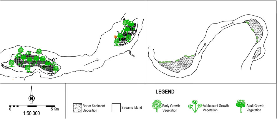
FIGURE 1. A typical schematic design of stream islands versus stream bars.
The majority of studies have documented the formation of stream islands in relation to their specific study site; for example, Gurnell et al. (2001) investigated the influence of riparian vegetation, sediment type, and hydrologic regime on island formation in the Fiume Tagliamento in Italy. They created a conceptual model for island formation in the research area and discovered that islands arise by channel avulsion or vegetation on exposed gravel bars. Popov (1962) defined the types of island modifications that he noticed in the River Ob in Russia. Meanwhile, Osterkamp (1998) examined all of the processes that might be linked with islands in more detail. He proposed categorizing islands into at least eight groups depending on their development process, as in the preceding explanations. Cooperman and Brewer (2005) predicted that fluvial dynamics influence the maturation of stream islands and that patterns of vegetation distribution would correlate to patterns of island growth (Figure 2). In general, stream island formation processes consist of 9 categories: avulsion, gradual erosion, lateral shifts, bar/riffle stabilization, structural features, flood deposits, lee deposits, mass movement, and reservoir installation.

FIGURE 2. The step-by-step process of concept design of stream island development ((A) Initial formation of bars; (B) Accumulated bar with woody debris; (C) Bar with early vegetation growth; (D) Sediment deposition stabilized; (E) Initial stream island; (F) Established stream island).
The conceptual framework for stream island development was designed for specific purposes such as stream health and stream restoration. The ecological variables in vegetation development and microinvertebrate indicators should be counted in stream island development. The degree of vegetation development on stream islands is likely to be related to the amount of time the surface has been exposed above the seasonal low-water level, the position of the water table, the physical character of sediments and their stability, and the types of vegetation available for colonization. Depending on these factors, newly formed stream islands are progressively vegetated as they accrete vertically and laterally and it thus becomes difficult to define where an initial stream island becomes a complex stream island. There are multiple stream island habitat types based on a literature review (Table 1; Figure 3).

TABLE 1. Stream island habitats.
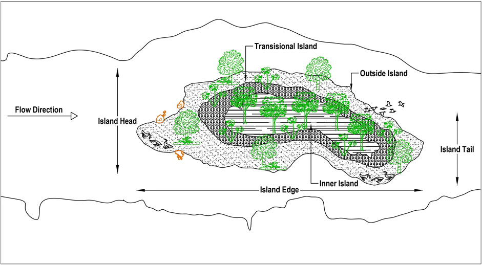
FIGURE 3. A typical design of habitat island types.
This study proposes a conceptual framework for developing a stream island evaluation index for sustainable stream restoration projects. It seems essential that a serious attempt be made to design a system that can identify the overall stream island condition. Once a generalized stream island system is set up as a controlling framework, supplementary indexes for specific purposes and locations can be added.
This study provides a comprehensive methodological process for developing a conceptual framework of the Stream Island Index (SII) (Figure 4; Table 2). The purpose should be defined first. In constructing a conceptual framework, this study emphasizes the ecological aspect in addition to the hydraulics and geomorphology attributes. In the framework of a design and method study, it appears necessary to create and validate an index for measuring the parameters involved. A considerable effort was made to develop an index system capable of measuring the overall status of stream islands. In order to develop an index, first it is important to identify the concept or variable to measure and then the selected variables should be included in the developing index. Then, assign scores to each variable. The scores should be based on the relative importance of each variable to the concept or variable. This means the level or weight of importance is defined. The next step is to combine the scores of the individual variables to create the index. Detailed steps to create an index can be seen in Table 2. According to a previous study (Chavez and Alipaz, 2006), one common approach is to take the average of the scores of the individual variables. Therefore, in this offered analysis, an index formed by attributes meeting the above criteria could be universally applied, which would significantly increase their usefulness in establishing the development of the SII in a matrix scheme. Numerically, the SII can therefore be represented as:
Where wi is the average weight factor for the ith parameter, and Ci is the standardized sub-index for the ith parameter. Each quality value is then multiplied by an average weight factor, to take into account the relative contribution of each variable to the overall index.
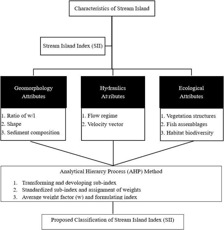
FIGURE 4. A conceptual framework of the Stream Island Index (SII).
TABLE 2. Methods for developing SII.
This study also used the Analytical Hierarchy Process (AHP) method to process the development of the SII. In the early 1970s, Thomas L. Saaty invented a structured mathematics and psychology strategy for organizing and analyzing complex decisions by entailing and decomposing a complex decision into a set of criteria and subcriteria. This method allows the decision-maker to use a pairwise comparison matrix to analyze the relative value of each criterion and subcriterion. In the process of AHP, it is also necessary to have the weighted importance of each criterion and subcriterion, as well as the overall ranking of the alternatives, in order to analyze and calculate it.
In the context of applying the AHP to the development of the SII, there are several stages for developing the SII (Table 2). First, spatial data should be generated by spatial analysis that reveal the geometric or geographic properties. Spatial data could use a computational model such as a Geographic Information System (GIS)-based model. This study proposes the rapid advancement of ArcGIS combined with Google-Earth software in spatial analyses of environmental stream island and habitat data triggered the need for change in methods of field survey measurements. Next, interviews with experts would be conducted in order to proceed with the AHP method. Expert judgments have often been used to acquire criteria weights when there is a lack of the required data (Reza et al., 2013) and software such as Expert Choice 11.0 is used to analyze multi-criterion decision-making problems based on the AHP approach. The experts thus evaluate the various criteria and alternatives using a numerical scale, as shown in Table 3. Overall, AHP is considered a robust decision-making tool in order to develop the SII. One restriction is that AHP is sensitive to the decision-maker’s pairwise comparisons.
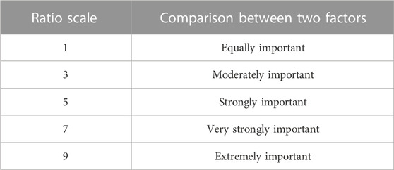
TABLE 3. Ratio scale used with 2, 4, 6, and 8 as the mid-values.
Concerning field survey measurements especially in fish assemblages indicators, sampling fish by using an electrofishing device is the appropriate method. This method identifies specific fish habitat use in streams. Moreover, the snorkeling method also can be used in clear stream conditions with some constraints such as the observer’s ability to identify species and is characterized by spatial and temporal heterogeneity across various scales.
Civil engineers, environmental engineers, stream ecologists, aquatic biologists, and other stakeholders all embark on stream restoration projects from a disciplinary perspective. However, the lack of integration among these various practitioners has resulted in limited project success in many cases. Stream islands in restoration projects have an important role since ecological failures have often occurred from engineering designs that ignore their existence. Therefore, to avoid such effects, it is necessary to ensure that the geomorphology, hydraulics, and ecological attributes of stream islands are mutually considered within the stream restoration design process. The proposed design framework for stream restoration projects, as conceptualized by naturalization, applies fluvial geomorphology, hydraulic engineering, and stream ecology to provide a more robust design approach to design in human-dominated stream management, and has a greater potential of success in achieving ecosystem stability. Integration of three attributes requires a three-dimensional view of stream island morphology and hydraulics, along with ecological patterns that express habitat complexity with biological needs. From a new view of stream island habitat and its analysis, ecological criteria will be better integrated into stream restoration projects for application by water resource professionals.
Many previous studies have focused on fluvial systems that maintain stream islands by addressing the need to understand aquatic ecology ecosystem functioning (e.g., Osterkamp, 1998; Edwards et al., 1999; Gurnell and Petts, 2002; Tockner et al., 2003; Karaus et al., 2005; Francis et al., 2009). Recent research has also highlighted the important role of feedback between organisms and physical processes in determining the spatial structure and dynamics of ecosystems, both terrestrial and aquatic (Francis et al., 2009). One of the results is the aggregating of sediment and hydraulic roughness on the gravel bars, creating the stabilization of the initial stream island. In some cases, the stream island is formed by the gravel bar and the deposition of large woody debris (LWD) above. Usually, organic matter, fine sediments, and creatures (e.g., plant propagules, fish, crustaceans) are caught in and surround deposited large woody debris or vegetation that can support stream island process development (Karaus et al., 2005).
In conclusion, it is important to have a comprehensive methodology as a template for physical habitat complexity assessment in stream restoration projects. This study introduced the Stream Island Index (SII) as a valuable tool for stream restoration practitioners or policymakers by using a single number to measure the quality of stream island habitats. Furthermore, the SII can be used for specific purposes in order to improve the quality and diversity of physical habitats in stream restoration projects. The SII can also be used to monitor and evaluate the stream restoration process in adaptive stream management strategies.
In further studies, some potential variables such as numbers, size, distribution, and location of stream islands and some in-stream features such as riffles, pools, and large woody debris (LWD) could be considered in the SII components in order to assess the physical habitat complexity of stream islands. However, it may be beneficial to develop regional-specific templates within the SII framework. These regional-specific templates would take into account the unique characteristics and dynamics of different geographic regions.
The original contributions presented in the study are included in the article/Supplementary Material, further inquiries can be directed to the corresponding author.
RT: Conceptualization, Writing–original draft.
The author(s) declare that no financial support was received for the research, authorship, and/or publication of this article.
The authors gratefully acknowledge the support for this research provided by Universitas Kristen Maranatha (Maranatha Christian University), Indonesia, and under collaboration research with Hydraulics and Ocean Engineering Department, National Cheng Kung University, Taiwan R.O.C.
The author declares that the research was conducted in the absence of any commercial or financial relationships that could be construed as a potential conflict of interest.
All claims expressed in this article are solely those of the authors and do not necessarily represent those of their affiliated organizations, or those of the publisher, the editors and the reviewers. Any product that may be evaluated in this article, or claim that may be made by its manufacturer, is not guaranteed or endorsed by the publisher.
Chavez, E. A., and Alipaz, S. (2006). An integrated indicator based on basin hydrology, environment, life, and policy: the watershed sustainability index. Water Resour. Manag. 21 (5), 883–895. doi:10.1007/s11269-006-9107-2
Comiti, F., Da Canal, M., Surian, N., Mao, L., Picco, L., and Lenzi, M. (2011). Channel adjustments and vegetation cover dynamics in a large gravel bed river over the last 200 years. Geomorphology 125 (1), 147–159. doi:10.1016/j.geomorph.2010.09.011
Cooperman, M. S., and Brewer, C. A. (2005). Relationship between plant distribution patterns and the process of river island formation. Freshw. Ecol. 20 (3), 487–501. doi:10.1080/02705060.2005.9664764
Edwards, P. J., Kollmann, J., Gurnell, A. M., Petts, G. E., Tockner, K., and Ward, J. V. (1999). A conceptual model of vegetation dynamics on gravel bars of a large Alpine river. Wetlands. Ecol. Manag. 7, 141–153. doi:10.1023/a:1008411311774
Francis, R. A., Corenblit, D., and Edwards, P. J. (2009). Perspectives on biogeomorphology, ecosystem engineering and self-organisation in island-braided fluvial ecosystems. Aquat. Sci. 71, 290–304. doi:10.1007/s00027-009-9182-6
Gurnell, A. M., Petts, G. E., Hannah, D. M., Smith, B. P. G., Edwards, P. J., Kollmann, J., et al. (2001). Riparian vegetation and island formation along the gravel-bed Fiume Tagliamento, Italy. Earth Surf. Process. Landforms 26, 31–62. doi:10.1002/1096-9837(200101)26:1<31::aid-esp155>3.0.co;2-y
Gurnell, A. M., and Petts, G. E. (2002). Island-dominated landscapes of large floodplain rivers, a European perspective. Freshw. Biol. 47, 581–600. doi:10.1046/j.1365-2427.2002.00923.x
Herrington, C. S., and Horndeski, K. (2023). Is urban stream restoration really a wicked problem? Urban Ecosyst. 26 (2), 479–491. doi:10.1007/s11252-022-01307-7
Karaus, U., Alder, L., and Tockner, K. (2005). “Concave islands”: habitat heterogeneity of parafluvial ponds in a gravel-bed river. Wetlands 25, 26–37. doi:10.1672/0277-5212(2005)025[0026:cihhop]2.0.co;2
Kaushal, S. S., Fork, M. L., Hawley, R. J., Hopkins, K. G., Ríos-Touma, B., and Roy, A. H. (2023). Stream restoration milestones: monitoring scales determine successes and failures. Urban Ecosyst. 26, 1131–1142. doi:10.1007/s11252-023-01370-8
Kollmann, J., Vieli, M., Edwards, P. J., Tockner, K., and Ward, J. V. (1999). Interactions between vegetation development and island formation in the Alpine river Tagliamento. Appl. Veg. Sci. 2, 25–36. doi:10.2307/1478878
Osterkamp, W. R. (1998). Processes of fluvial island formation, with examples from plum creek, Colorado and snake river, Idaho. Wetlands 18 (4), 530–545. doi:10.1007/bf03161670
Reza, M. I. H., Abdullah, S. A., Nor, S. B., and Ismail, M. H. (2013). Integrating GIS and expert judgment in a multi-criteria analysis to map and develop a habitat suitability index: a case study of large mammals on the Malayan Peninsula. Ecol. Indic. 34, 149–158. doi:10.1016/j.ecolind.2013.04.023
Rice, S. P., Church, M., Wooldridge, C. L., and Hickin, E. J. (2009). Morphology and evolution of bars in a wandering gravel-bed river; lower Fraser river, British Columbia, Canada. Sedimentology 56, 709–736. doi:10.1111/j.1365-3091.2008.00994.x
Rubin, Z., Kondolf, G. M., and Rios-Touma, B. (2017). Evaluating stream restoration projects: what do we learn from monitoring? Water 9 (3), 174. doi:10.3390/w9030174
Smith, N. D. (1974). Sedimentology and bar formation in the Upper Kicking Horse River, a braided outwash stream. J. Geol. 82, 205–223. doi:10.1086/627959
Tockner, K., and Stanford, J. A. (2002). Riverine flood plains: present state and future trends. Environ. Conserv. 29, 308–330. doi:10.1017/s037689290200022x
Tockner, K., Ward, J. V., Arscott, D. B., Edwards, P. J., Kollmann, J., Gurnell, A. M., et al. (2003). The Tagliamento River: a model ecosystem of European importance. Aquat. Sci. 65, 239–253. doi:10.1007/s00027-003-0699-9
Verdonschot, P. F. M., and Verdonschot, R. C. M. (2023). The role of stream restoration in enhancing ecosystem services. Hydrobiologia 850 (12-13), 2537–2562. doi:10.1007/s10750-022-04918-5
Keywords: index, habitat characteristics, stream island, stream restoration projects, AHP
Citation: Tallar RY (2023) The conceptual design of a stream island index for physical habitat complexity assessment in stream restoration projects. Front. Built Environ. 9:1286484. doi: 10.3389/fbuil.2023.1286484
Received: 31 August 2023; Accepted: 25 September 2023;
Published: 13 October 2023.
Edited by:
Alfrendo Satyanaga, Nazarbayev University, KazakhstanReviewed by:
Abdul Halim Hamdany, University of Indonesia, IndonesiaCopyright © 2023 Tallar. This is an open-access article distributed under the terms of the Creative Commons Attribution License (CC BY). The use, distribution or reproduction in other forums is permitted, provided the original author(s) and the copyright owner(s) are credited and that the original publication in this journal is cited, in accordance with accepted academic practice. No use, distribution or reproduction is permitted which does not comply with these terms.
*Correspondence: Robby Yussac Tallar, cm9iYnl5dXNzYWNAeWFob28uY29t, cm9iYnkueXRAZW5nLm1hcmFuYXRoYS5lZHU=
Disclaimer: All claims expressed in this article are solely those of the authors and do not necessarily represent those of their affiliated organizations, or those of the publisher, the editors and the reviewers. Any product that may be evaluated in this article or claim that may be made by its manufacturer is not guaranteed or endorsed by the publisher.
Research integrity at Frontiers
Learn more about the work of our research integrity team to safeguard the quality of each article we publish.