 Ricardo A. Scrosati
Introduction
Coastal upwelling is the upsurge of water to the surface of coastal marine environments as surface waters move offshore. Upwelled waters are typically colder than the surface waters they replace, so upwelling is normally associated with sea surface cooling. Such thermal changes affect the ecology of coastal species and influence coastal climate through sea–air interactions. In addition, upwelled waters bring inorganic nutrients to the surface and thus enhance coastal biological productivity and fisheries (Varela et al., 2018; Menge et al., 2019; FAO, 2020; Yu et al., 2020). Thus, considerable efforts have been done to understand the factors that drive coastal upwelling. On many shores worldwide, coastal winds and the Coriolis force constitute together an important driver. Alongshore winds blowing with the coast on the left in the northern hemisphere and on the right in the southern hemisphere generate an offshore surface Ekman transport that triggers coastal upwelling (Stewart, 2008; Kämpf and Chapman, 2016).
While typical upwelling-favorable winds occur at relatively predictable times of the year, unpredictable extreme events may cause unexpected spikes in upwelling and coastal cooling. Such is the case of cyclones, which can significantly cool surface coastal waters in part through wind-driven coastal upwelling (Doong et al., 2019). A recent example was the arrival of cyclone Dorian to the Atlantic Canadian coast in the summer of 2019. On two coastal locations to the east of this cyclone's path (Barachois Head and Deming Island), Bakun's upwelling index (UI) reached values more than 700% higher than the week before Dorian and sea surface temperature (SST) dropped by 10–12°C just hours after this cyclone's landfall. Such a marked cooling was consistent with favorable wind conditions for such a spike in upwelling (Scrosati, 2020a).
The intensity of coastal upwelling depends on wind speed (which determines wind stress) and also on wind direction relative to the angle of the coast (Stewart, 2008; Kämpf and Chapman, 2016). Therefore, given the spiral (counterclockwise in the northern hemisphere) circulation of surface winds around a cyclone's center (Young, 2003; Wang and Wu, 2004; Wang and Toumi, 2018), the position of a coastal location relative to the cyclone's path could influence the intensity of the resulting coastal upwelling and cooling. This paper examines data on SST, winds, and UI measured for a Canadian coastal location to the west of Dorian's path to test this hypothesis. This data set is hereby made available also to help future studies that may require in-situ oceanographic information for the Atlantic Canadian coast.
Materials and Methods
Dorian approached Atlantic Canada as a hurricane from the south (Ezer, 2020) and made landfall as a post-tropical cyclone near Halifax (Nova Scotia) at 19:15, local time (Atlantic Daylight Time = UTC-3), on 7 September 2019 (AccuWeather, 2019; NOAA, 2020). The two previously studied coastal locations east of Dorian's path (Barachois Head and Deming Island) are 136 and 179 km, respectively, from the place where Dorian made landfall (Figure 1; NOAA, 2020). For the present study, SST was measured at Western Head (N 43.9896, W 64.6607), which is a location west of Dorian's path distant 130 km from the place where this cyclone made landfall (Figure 1). To evaluate Dorian's influence on SST, winds, and UI at Western Head most clearly, data measured between 1 and 16 September 2019 are hereby considered.
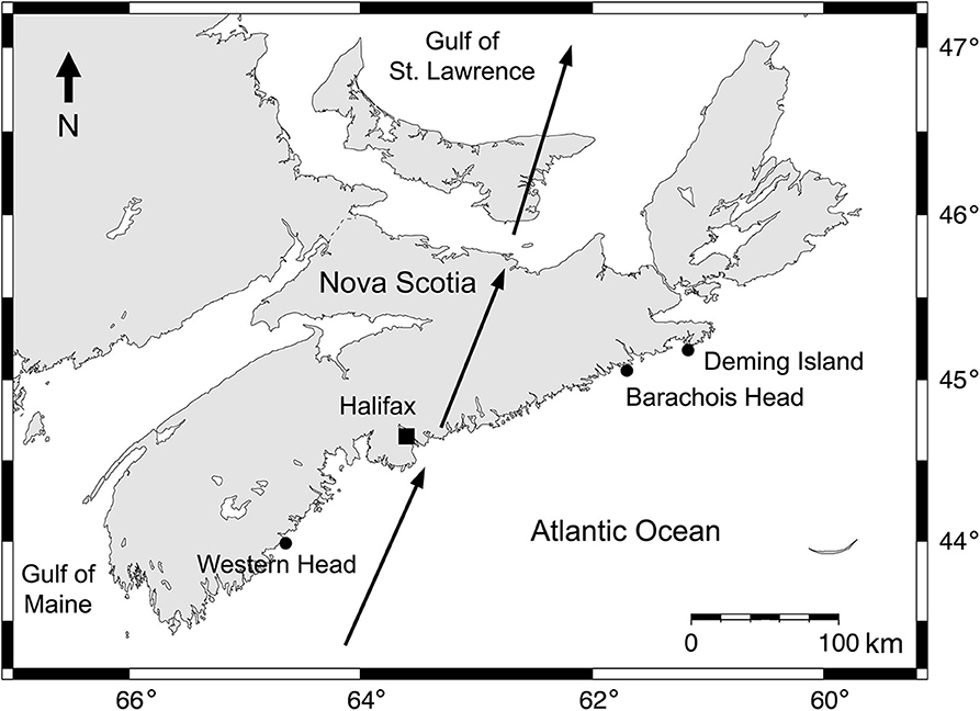
Figure 1. Map of Nova Scotia, showing the path of cyclone Dorian's center (arrows) and the position of Western Head and the two previously studied locations (Deming Island and Barachois Head) east of Dorian's track.
Western Head is a wave-exposed, rocky intertidal location that faces the open Atlantic Ocean directly. During the studied period, temperature was measured in-situ every half hour with a submersible logger (HOBO Pendant logger, Onset Computer, Bourne, MA, USA) that was attached to the intertidal substrate (bedrock) by plastic cable ties secured to eye screws drilled into the substrate. From the resulting time series of temperature values (which spanned alternating periods of high and low tide), SST values were extracted. To do this, first the time of the successive peaks of high tide was determined using information for the tide reference station closest to Western Head (Liverpool, N 44.0500, W 64.7167; Tide and Current Predictor, 2020). Then, the temperature value recorded by the logger by the time of each high tide, when the logger was fully submerged, was extracted. The resulting SST data set is available from the figshare online repository (Scrosati, 2020b).
Data on hourly wind speed and direction were retrieved for a weather station nearly 300 m from Western Head (also called Western Head, N 43.9900, W 64.6642; Government of Canada, 2020). Using such wind data, UI was calculated hourly following the steps detailed elsewhere (Scrosati and Ellrich, 2020), considering an orientation of the coast of 60° measured clockwise relative to the north. This paper expresses UI as cubic meters of seawater transported per second per 100 m of coastline. Positive UI values indicate upwelling, whereas negative UI values indicate downwelling (Kämpf and Chapman, 2016). The resulting data set on wind speed and direction and on UI is also available from the figshare online repository (Scrosati, 2020b).
Results
Unlike at Barachois Head and Deming Island, at Western Head there was no noticeable cooling shortly after Dorian's passage (Figure 2A). At Western Head, SST averaged 17.2°C (range = 15.3–18.9°C) between 1 and 7 September before Dorian's landfall and 17.3°C (range = 16.7–17.9°C) between 8 and 9 September (Figure 2A). At Barachois Head and Deming Island, SST decreased by 10–12°C during 8 September, reaching 6.8°C and 9.7°C, respectively, just hours after Dorian's passage through this region (Scrosati, 2020a).

Figure 2. Temporal changes in (A) sea surface temperature (SST), (B) wind speed, (C) wind direction (angle measured clockwise from the north −0°− indicating the direction where the wind came from), and (D) Bakun's upwelling index between 1 and 16 September 2019 at Western Head. The range of values in the four Y axes are the same as those used in Scrosati (2020a) to facilitate visual comparisons with that study. In the X axes, the daily tick marks are placed at the beginning of each day.
At Western Head, hourly values of wind speed did not surpass 26 km h−1 before 7 September (Figure 2B). Wind speed did increase with the arrival of Dorian on 7 September, but its highest hourly value of 54 km h−1 (Figure 2B) was noticeably lower than for Barachois Head and Deming Island, where hourly wind speed on that day peaked at 106 and 88 km h−1, respectively (Scrosati, 2020a). Also, while maximum wind gust was 145 and 126 km h−1 at Barachois Head and Deming Island, respectively, on 7 September, maximum wind gust only reached 88 km h−1 at Western Head on that day (Government of Canada, 2020).
At Western Head, wind direction during the hours after Dorian's landfall (Figure 2C) was less favorable for coastal upwelling than for Barachois Head and Deming Island (Scrosati, 2020a). Ultimately, as a consequence of the less intense winds and less upwelling-favorable wind direction, UI for Western Head did peak near the time of Dorian's landfall, but this value of 79 m3 s−1 (100 m of coastline)−1 (Figure 2D) was considerably lower than for Barachois Head and Deming Island, where UI peaked at 689 m3 s−1 (100 m of coastline)−1 and 411 m3 s−1 (100 m of coastline)−1, respectively, on 7 September (Scrosati, 2020a).
It is also worth noting that a marked downwelling was recorded at Western Head (Figure 2D) as well as at Barachois Head and Deming Island (Scrosati, 2020a) shortly before Dorian's landfall, but such an occurrence was not expected to decrease SST because coastal downwelling does not bring cool waters to the surface.
Discussion and Conclusions
The present study supports the hypothesis that the position of a coastal location relative to a cyclone's path can influence the intensity of the resulting coastal upwelling and cooling. At the two previously studied coastal locations east of Dorian's path in Nova Scotia (Barachois Head and Deming Island), winds were intense and upwelling-favorable with the passage of this cyclone, triggering a marked coastal upwelling and SST drop shortly after this cyclone's landfall (Scrosati, 2020a). However, at Western Head, located at a similar distance from Dorian's landfall but west of its path, winds were less intense and their direction was less favorable for coastal upwelling, thus resulting in weaker upwelling and, ultimately, little change in coastal SST even when measured for 2 days after Dorian's landfall. A recent study that focused on a northeast-facing location on the Taiwan coast led to an equivalent conclusion, as westward typhoons passing south of that location triggered a stronger coastal SST drop through wind-driven upwelling than westward typhoons passing north of that location (Doong et al., 2019). Therefore, for the northern hemisphere, it seems that coastal locations situated to the right of a cyclone's path will likely experience stronger upwelling and cooling than coastal locations situated to the left of a cyclone's path. It is worth noting that surface cooling also occurs in open oceanic waters with the passage of cyclones and that, although such SST drops are often smaller than on coastal areas, they are also generally more pronounced to the right of a cyclone's path (Breaker et al., 1994; Subrahmanyam, 2015; Glenn et al., 2016).
Overall, the SST values obtained for this study are particularly valuable because they were measured in-situ, which is an approach that avoids the inaccuracies often inherent in SST estimations done for coastal environments using satellites (Smale and Wernberg, 2009; Seroka et al., 2016).
Coastal upwelling and the resulting cooling influence coastal oceanography, climate, and ecology (Varela et al., 2018; Menge et al., 2019; FAO, 2020; Yu et al., 2020). Therefore, considerable research is being done to better understand the factors that regulate the occurrence and intensity of coastal upwelling. Cyclones can trigger intense coastal upwelling (Doong et al., 2019; Scrosati, 2020a), although the position of a coastal location relative to a cyclone's path can greatly influence upwelling intensity, as shown by this study and by Doong et al. (2019). The average intensity of cyclones is increasing with climate change (Glenn et al., 2016; Lin et al., 2020). Therefore, it is hoped that the present study stimulates further research to keep improving our understanding about cyclone influences on coastal upwelling and cooling.
Data Availability Statement
The full data set described in this Data Report is freely available from the figshare online repository: https://doi.org/10.6084/m9.figshare.12575975.v1.
Author Contributions
The author confirms being the sole contributor of this work and has approved it for publication.
Funding
This study was funded by a Discovery Grant (#311624) from the Natural Sciences and Engineering Research Council of Canada awarded to the author.
Conflict of Interest
The author declares that the research was conducted in the absence of any commercial or financial relationships that could be construed as a potential conflict of interest.
Acknowledgments
I thank Matthew J. Freeman for field assistance and two reviewers for constructive comments on an earlier version of this article.
References
AccuWeather (2019). Dorian Made 6th Landfall at Nova Scotia; Thousands Without Power. Available online at: https://www.accuweather.com/en/weather-news/dorain-made-5th-landfall-as-it-reaches-nova-scotia/70009277
Breaker, L. C., Burroughs, L. D., Chao, Y. Y., Culp, J. F., Guinasso, N. L., Teboulle, R. L., et al. (1994). The impact of hurricane Andrew on the near-surface marine environment in the Bahamas and the Gulf of Mexico. Weather Forecast. 9, 542–556. doi: 10.1175/1520-0434(1994)009<0542:Tiohao>2.0.Co;2
Doong, D. J., Peng, J. P., and Babanin, A. V. (2019). Field investigations of coastal sea surface temperature drop after typhoon passages. Earth Syst. Sci. Data 11, 323–340. doi: 10.5194/essd-11-323-2019
Ezer, T. (2020). The long-term and far-reaching impact of hurricane Dorian (2019) on the Gulf Stream and the coast. J. Mar. Syst. 208:103370. doi: 10.1016/j.jmarsys.2020.103370
FAO (2020). The State of World Fisheries and Aquaculture 2020. Rome: Food and Agriculture Organization of the United Nations, 244.
Glenn, S. M., Miles, T. N., Seroka, G. N., Xu, Y., Forney, R. K., Yu, F., et al. (2016). Stratified coastal ocean interactions with tropical cyclones. Nat. Commun. 7:10887. doi: 10.1038/ncomms10887
Government of Canada (2020). Past Weather and Climate. Historical Data. Available online at: http://climate.weather.gc.ca/historical_data/search_historic_data_e.html
Kämpf, J., and Chapman, P. (2016). Upwelling Systems of the World. A Scientific Journey to the Most Productive Marine Ecosystems. Cham: Springer, 433. doi: 10.1007/978-3-319-42524-5
Lin, T. C., Hogan, J. A., and Chang, C. T. (2020). Tropical cyclone ecology: A scale-link perspective. Trends Ecol. Evol. 35, 594–604. doi: 10.1016/j.tree.2020.02.012
Menge, B. A., Caselle, J. E., Milligan, K., Gravem, S. A., Gouhier, T. C., White, J. W., et al. (2019). Integrating coastal oceanic and benthic ecological approaches for understanding large-scale metaecosystem dynamics. Oceanography 32, 38–49. doi: 10.5670/oceanog.2019.309
NOAA (2020). National Oceanic and Atmospheric Administration. Historical Hurricane Tracks. Available online at: https://coast.noaa.gov/hurricanes
Scrosati, R. A. (2020a). Upwelling spike and marked SST drop after the arrival of cyclone Dorian to the Atlantic Canadian coast. J. Sea Res. 159:101888. doi: 10.1016/j.seares.2020.101888
Scrosati, R. A. (2020b). SST, Wind, and Upwelling Data for Western Head, Nova Scotia. Figshare Data Set. doi: 10.6084/m9.figshare.12575975.v1
Scrosati, R. A., and Ellrich, J. A. (2020). Marked contrast in wind-driven upwelling on the southeastern Nova Scotia coast in July of two years differing in ENSO conditions. Oceanol. Hydrobiol. Stud. 49, 81–87. doi: 10.1515/ohs-2020-0008
Seroka, G., Miles, T., Xu, Y., Kohut, J., Schofield, O., and Glenn, S. (2016). Hurricane Irene sensitivity to stratified coastal ocean cooling. Mon. Weather Rev. 144, 3507–3530. doi: 10.1175/MWR-D-15-0452.1
Smale, D. A., and Wernberg, T. (2009). Satellite-derived SST data as a proxy for water temperature in nearshore benthic ecology. Mar. Ecol. Prog. Ser. 387, 27–37. doi: 10.3354/meps08132
Stewart, R. H. (2008). Introduction to Physical Oceanography. Open Textbook Library. Available online at: https://open.umn.edu/opentextbooks/textbooks/introduction-to-physical-oceanography
Subrahmanyam, M. V. (2015). Impact of typhoon on the north-west Pacific sea surface temperature: a case study of Typhoon Kaemi (2006). Nat. Hazards 78, 569–582. doi: 10.1007/s11069-015-1733-7
Tide and Current Predictor (2020). Tidal Height and Current Site Selection. Available online at: http://tbone.biol.sc.edu/tide/index.html
Varela, R., Lima, F. P., Seabra, R., Meneghesso, C., and Gómez-Gesteira, M. (2018). Coastal warming and wind-driven upwelling: a global analysis. Sci. Total Environ. 639, 1501–1511. doi: 10.1016/j.scitotenv.2018.05.273
Wang, S., and Toumi, R. (2018). A historical analysis of the mature stage of tropical cyclones. Int. J. Climatol. 38, 2490–2505. doi: 10.1002/joc.5374
Wang, Y., and Wu, C. C. (2004). Current understanding of tropical cyclone structure and intensity changes - a review. Meteorol. Atmos. Phys. 87, 257–278. doi: 10.1007/s00703-003-0055-6
Young, I. R. (2003). A review of the sea state generated by hurricanes. Mar. Struct. 16, 201–218. doi: 10.1016/S0951-8339(02)00054-0
Keywords: Bakun's index, coastal upwelling, cyclone, hurricane, sea surface temperature, SST, typhoon, wind-driven upwelling
Citation: Scrosati RA (2020) Cyclone-Driven Coastal Upwelling and Cooling Depend on Location Relative to the Cyclone's Path: Evidence From Dorian's Arrival to Atlantic Canada. Front. Mar. Sci. 7:651. doi: 10.3389/fmars.2020.00651
Received: 26 June 2020; Accepted: 16 July 2020;
Published: 31 August 2020.
Edited by:
Juan Jose Munoz-Perez, University of Cádiz, SpainReviewed by:
Raul Martell-Dubois, National Commission for the Knowledge and Use of Biodiversity (CONABIO), MexicoJill Trepanier, Louisiana State University, United States
Copyright © 2020 Scrosati. This is an open-access article distributed under the terms of the Creative Commons Attribution License (CC BY). The use, distribution or reproduction in other forums is permitted, provided the original author(s) and the copyright owner(s) are credited and that the original publication in this journal is cited, in accordance with accepted academic practice. No use, distribution or reproduction is permitted which does not comply with these terms.
*Correspondence: Ricardo A. Scrosati, cnNjcm9zYXRAc3RmeC5jYQ==