
94% of researchers rate our articles as excellent or good
Learn more about the work of our research integrity team to safeguard the quality of each article we publish.
Find out more
PERSPECTIVE article
Front. Mar. Sci. , 05 April 2019
Sec. Marine Conservation and Sustainability
Volume 6 - 2019 | https://doi.org/10.3389/fmars.2019.00166
This article is part of the Research Topic 5th International Marine Conservation Congress View all 23 articles
 Amanda T. Lombard1*
 Natalie C. Ban2
 Joanna L. Smith3
 Sarah E. Lester4Kerry J. Sink1,5Spencer A. Wood6
 Aerin L. Jacob2†Zacharoula Kyriazi7
 Richard Tingey8
 Helena E. Sims9
Marine spatial planning (MSP) processes seek to better manage ocean spaces by balancing ecological, social and economic objectives using public and participatory processes. To meet this challenge, MSP approaches and tools have evolved globally, from local to national scales. At two International Marine Conservation Congresses (2016 and 2018), MSP practitioners and researchers from diverse geographic, technical and socio-economic contexts met to share advances in practical approaches and spatial tools to achieve multi-objective MSP. Here we share the lessons learned and commonalities that emerged from studies conducted in Belize, Canada, South Africa, Seychelles, the United Kingdom and the United States on a number of topics related to advancing MSP. We identify seven important themes that we believe are broadly relevant to any multi-objective MSP process: (1) indigenous and local knowledge should inform planning goals and objectives; (2) transparent and evidence-based approaches can reduce user conflict; (3) simple ecosystem service models and scenarios can facilitate multi-objective planning; (4) trade-off analyses can help balance diverse objectives; (5) ecosystem services may assist planning for high value-data poor Blue Economy sectors; (6) game theoretic decision rules can help to deliver fair, equitable and win–win spatial allocation solutions; and (7) strategic mapping products can facilitate decision making amongst stakeholders from different sectors. Some of these themes are evident in MSP processes that have been completed in the previous decade, but the fast-evolving field of MSP is addressing increasingly more complex objectives, and practitioners need to respond with practical approaches and spatial tools that can address this complexity.
Over the last decade, marine spatial planning (MSP) has become an increasingly accepted approach to achieve multiple objectives for ocean management. At least 13 countries have approved marine plans covering 7% of the world’s Exclusive Economic Zones and Territorial Seas. By 2025, marine plans may be implemented in more than 40 countries around the world including several Small Island Developing States (SIDS) (Smith, 2017). MSP presents several significant challenges including choosing appropriate data, models and decision support tools to inform the planning process. Advances in approaches to, and spatial tools for, multi-objective marine planning are necessary to address particular challenges posed by the different spatial, temporal and socio-economic scales of uses and activities in a given planning context (De Santo, 2013). To date, almost 100 decision-support tools for MSP have been developed (Beck et al., 2009; Bolman et al., 2018) but there is varied success for using these tools during real-world planning processes, particularly in data-poor geographies and SIDS (Pınarbaşı et al., 2017).
Given that MSP is a public and participatory process to address ecological, social, and economic objectives with stakeholders in a transparent way, decision-support tools need to be able to estimate, visualize, and evaluate trade-offs among overlapping uses or conflicts among activities. The science and practice of developing and using technical and spatial tools for MSP is evolving, including more explicit consideration of ecosystem services (Arkema et al., 2015) and approaches to conflict analysis and management. Fast-tracking of MSP processes globally has also provided an opportunity for spatial tools to advance in their capacity to address multiple objectives and move from sector-specific to multi-objective planning.
Here, we present recent advances in practical approaches and spatial tools from several ongoing marine planning efforts. These studies were presented during two special sessions at the Society for Conservation Biology’s International Marine Conservation Congresses (IMCC) in 2016 and 2018 and involve a range of interdisciplinary approaches, contexts, and geographies. We provide case study examples from six countries, spanning seven broad themes relevant to any multi-objective MSP process. In Canada (British Columbia), we demonstrate that indigenous and local knowledge should inform planning goals and objectives, and that evidence-based approaches can reduce user conflict; in Belize, we show how simple ecosystem service models and scenarios can facilitate multi-objective planning; in the United States (California), trade-off analyses have helped balance diverse objectives; in the Seychelles, we demonstrate how ecosystem services may assist planning for high value-data poor Blue Economy sectors; in the United Kingdom, we used game theoretic decision rules to help deliver fair, equitable and win–win spatial allocation solutions; and in South Africa, we show how strategic mapping products can facilitate decision making amongst stakeholders from different sectors.
Although the approaches presented here are not comprehensive and do not represent a systematic review of all active processes around the world, they reflect an assortment of actual on-the-ground experiences that we believe are broadly relevant and can contribute to the evolution of MSP today.
People who live and work on or near the ocean observe changes over their lifetimes and can also accumulate generations of knowledge regarding previous baselines of marine resources. In the case of Indigenous peoples, wisdom and practices are passed down through generations, for example, in the form of dances, stories, traditions, and Indigenous laws (Berkes, 2018). This local and Indigenous knowledge should be considered paramount to informing MSP goals and objectives. Our research illustrates this point.
We developed community–academic research partnerships (Ban et al., 2018) to identify changes in size and abundance over the past 50 years of some focal species in order to inform MSP and fisheries management. The partnerships were created at the request of four First Nations (Indigenous peoples) on the central coast of British Columbia, Canada. Two species were of particular concern to them (Dungeness crab, Cancer magister; and Yelloweye rockfish, Sebastes ruberrimus) because these species are culturally important yet also targeted by commercial and recreational fisheries. Although our research focused on these two species, the methods are applicable to any species. We used a mixed methods approach, combining semi-structured interviews with ecological surveys and modeling to gauge the changes in these species between peoples’ living memories (i.e., the first-time participants remember fishing for these species in their youth or early adulthood) and recent years. Ecological surveys and stock assessments either did not exist at all or were started only in the 2000s. We found that size (Yelloweye rockfish) and abundance (both species) had declined substantially, and that in some cases First Nations were unable to meet their needs for their constitutionally protected right to fish for food and for social and ceremonial purposes (Ban et al., 2017; Eckert et al., 2018). These results were brought by the First Nations partners to policy discussions, and they have resulted in changes to spatial management. More specifically, important crab fishing areas were closed to commercial and recreational fishing, and findings about the changes in sizes of Yelloweye rockfish are being incorporated into the latest assessment of this species of special concern.
These studies illustrate the importance of local and Indigenous knowledge in informing goals and objectives in marine planning. As is commonly the case globally, scientific surveys of these and other important species either did not exist or were started only recently. Without the information gathered from interviews, shifted baseline (e.g., significantly reduced biomasses of important species) might have been used to set default objectives (Pauly, 1995) in the absence of historical information. The community–academic partnerships were an effective trans-disciplinary approach to filling the data gap and engaging people in thinking about future scenarios for these species.
On Canada’s North Pacific Coast, the Province of British Columbia (BC) and 17 Coastal First Nations recently co-developed marine spatial plans to support sustainable economic development and a healthy marine environment across more than 100,000 km2.1 There were four sub-regional planning areas: Haida Gwaii, the North Coast, the Central Coast, and North Vancouver Island, together comprising the North Pacific Coast of BC. But effective implementation of each marine plan requires evaluating how key marine uses interact, including linkages on land and under global environmental change (Marine Plan Partnership for the North Pacific Coast [MAPP], 2016). We worked with First Nations on the Central Coast to identify priority income-generating activities in the Great Bear Sea and adjacent Great Bear Rainforest, identifying and modeling relevant abiotic and biotic conditions, to be used in an ecosystem services approach to evaluate potential environmental and economic synergies and trade-offs. The two highest-priority activities to emerge were shellfish aquaculture (for geoduck, scallops, and oysters) followed by nature-based tourism (bear-viewing); we focus here on shellfish aquaculture.
Shellfish aquaculture has the potential to meet local and regional objectives regarding income generation and employment while also supporting the global demand for seafood. While parts of southern BC have successful shellfish aquaculture industries, the Central Coast does not. However, shellfish has been important for food, social and ceremonial harvest for Coastal First Nations across the North Pacific Coast for millennia. Exploring the development of this industry (specifically Japanese scallop, Patinopecten yessoensis; and geoduck clams, Panopea abrupta) was identified as a top priority among Coastal First Nations, provided it did not negatively affect other activities including established, growing and potential industries such as forestry or nature-based tourism, and that it would remain viable with changing ocean conditions (reviewed in Holden et al., 2019).
We defined the range of abiotic conditions for successful scallop and geoduck aquaculture, to help identify the suitable natural locations to optimize growth and minimize mass mortality events. Through interviews with members of the scallop and geoduck aquaculture industry and researchers, we identified the tolerable and most favorable parameters for substrate, depth, temperature, salinity, tidal speed (both species), productivity (geoduck) and wave height (scallop) (Lancaster, 2017). This information was used to inform habitat suitability models for both species in the Central Coast and would be used to compare current aquaculture zoning to areas and variables important for nature-based tourism (e.g., visual quality, beach access and locations to see bears).
We are using our results to recommend zoning that minimizes potential conflicts and maximizes compatibilities in linked marine, coastal and terrestrial environments. Combined with community engagement, this iterative process can adaptively manage multiple uses and activities to support human well-being, governance and ecological integrity.
Marine spatial planning processes are demonstrating how scientifically credible models and maps of ecosystem service production are helpful for balancing competing uses such as tourism, renewable energy, and commercial fisheries (Guerry et al., 2012; Arkema et al., 2015; Ruckelshaus et al., 2015). Ecosystem service modeling typically begins by quantifying the risks of human activities to the structure and function of natural habitats (Arkema et al., 2014), followed by modeling the benefits provided by natural habitats for people’s livelihoods and well-being through ecological production functions. By pairing multiple ecosystem services and metrics with spatially explicit scenarios that compare alternative management options, it is possible to highlight how proposed marine spatial plans create synergies and trade-offs among activities in space.
This approach to ecosystem service modeling was exemplified during the creation of the Belize Integrated Coastal Management Plan (Coastal Zone Management Authority and Institute [CZMAI], 2016). During the planning, teams of researchers, practitioners, and stakeholders evaluated how human impacts on coral, mangrove, and seagrass habitats would change the potential for ecosystems to provide coastal protection, tourism and lobster fishery benefits under three alternative management scenarios that promoted either habitat conservation, coastal development or “informed management” (Arkema et al., 2015). As a result, the plan explicitly considers how coastal management can provide benefits to multiple sectors and stakeholders, given their local visions and values (Verutes et al., 2017).
One important lesson to emerge from recent planning efforts is that simple process-based ecosystem service models and spatial tools can be more useful than traditional heuristic models. Simple quantitative models help planners prioritize information-gathering, build local capacity and align stakeholders and appropriate authorities (Rosenthal et al., 2015; Verutes et al., 2017). Furthermore, simple models allow for an iterative science and policy process—in which scientists, stakeholders, and decision-makers repeatedly re-evaluate proposed scenarios, predicted outcomes, and model assumptions throughout the planning process—and that can result in more robust marine plans (McKenzie et al., 2014). This iterative approach to co-creating scenarios, science and knowledge can produce more credible, transparent and effective tools that resonate with governments and stakeholders.
A marine spatial plan that uses predictive models and trade-off analysis can better balance diverse objectives for the use of ocean space, including development of emerging uses like offshore aquaculture and wind energy, while minimizing negative environmental impacts (Lester et al., 2013). Leveraging analytical models enables consideration of a broader array of concerns and goals, more objective decision-making and transparency around costs and benefits of different spatial planning options.
This assertion is demonstrated in a spatial planning analysis supporting the potential development of multiple types of offshore aquaculture in southern California (Lester et al., 2018b). The study developed spatial models of the predicted productivity and profitability of three marine aquaculture sectors (offshore kelp farms, offshore mussel farms, and finfish netpen farms), and linked these to spatial models of four existing sectors that represent important stakeholder concerns regarding aquaculture development: wild-capture fishery profits; the environmental health of the benthos given potential nutrient pollution from finfish farms; risk of disease outbreak among farms; and viewshed impacts from adding structures to the marine vista. These linked models were integrated with an analytical trade-off analysis that identified optimal spatial plans given a range of preference weightings for the different sectors. The analysis suggested thousands of optimal plans (depending on the preference profile), allowing value of individual sectors to be enhanced and negative impacts to be reduced relative to more conventional approaches to planning. For example, the analysis found that dramatic trade-offs are unavoidable only at very extreme levels of aquaculture development, and there are spatial planning options that would result in a significant new supply of seafood, providing billions of dollars in revenue, with small to no impact on existing sectors and the environment.
Although California has implemented a statewide network of marine protected areas (MPAs) through a process that included the use of predictive models and trade-off analyses to help balance conservation goals with fisheries objectives (Rassweiler et al., 2014), the region has not engaged in spatial planning for offshore aquaculture or other emerging ocean industries. However, this analysis has informed some discussions about potential future aquaculture developments in California, and if the region were to adopt a proactive spatial planning process that leveraged the analytical tools presented here, it could help to reduce the hurdles to development caused by regulatory uncertainty (Lester et al., 2018a). MSP can not only catalyze the development of a new industry, it can also safeguard that development follows a sustainable, rather than environmentally precarious, trajectory (Gentry et al., 2017). More generally, with an inevitable industrialization of the oceans on the near horizon around the world, multi-objective planning using predictive modeling and trade-off analyses can help achieve best-case outcomes.
There is an important need in multi-stakeholder MSP to identify current conditions and trends by compiling information for each sector (Ehler and Douvere, 2009). By compiling the best available information and representing stakeholder preferences in a Geographic Information System, it is also possible to identify missing data. Data gaps usually exist because the questions that need answering for an integrated and ecosystem-based marine spatial plan have not been previously asked or answered. MSP processes are relatively rapid; thus it is challenging to fill these gaps during planning, but they must be addressed to ensure equity amongst stakeholders (Fox et al., 2013) and to assess trade-offs (Yates et al., 2015).
Some sectors, such as fisheries, use a common property resource and have a long history of regulation that requires collecting and sharing detailed information about their activities with managers (e.g., effort and catch value). These data often follow rigorous protocols that ensure confidentiality and can then be used to describe the sector’s value within an economy. As a result, maps of activities, values and preferences are often available for decision-support tools to use to inform zoning, minimize impacts, and maximize benefits (Kenchington and Day, 2011; Agostini et al., 2015). In contrast, other sectors, such as tourism, rely on public and private resources and have very different reporting requirements that limit the type of data they are required to share about their activities. Obtaining access to these data for a marine spatial plan can be difficult because there are no or limited existing protocols to enable sharing and ensure confidentiality, which in turn creates challenges to represent high-priority areas for an equitable and transparent process.
In Seychelles, The Nature Conservancy is facilitating a MSP process on behalf of the government to expand marine protection, address climate change and support the Blue Economy for a 1.35 million km2 area (Smith et al., 2018a).2 More than 15 years of data were shared by the fisheries authority to create area-based values for that sector (Smith et al., 2018b). However, insufficient data were available for high-value tourism, the leading contributor to Seychelles’ gross domestic product (World Travel and Tourism Council [WTTC], 2017).
To map high-value tourism, we measured the relative distribution and abundance of visitation throughout the 115-island archipelago based on the number of geotagged photographs shared on the Flickr social media website from 2005 to 2014 (Wood et al., 2013; Keeler et al., 2015). Using a recreation ecosystem service model, we observed that tourism was highest around the accessible beaches and dive sites on the main island. However, without additional data on how relative differences in visitation reflect absolute differences in user days or expenditures, we lacked critical information for valuing tourism. The lack of long-term datasets and previous characterizations of the tourism sector also led to unanswered questions about the appropriate methods for defining ownership, administration and natural geographic boundaries. Nevertheless, this was an important first step in the process to represent high-priority areas for a significant sector in Seychelles’ Blue Economy. Since these maps were produced early in the planning process, the MSP initiative provided opportunities to work with the marine tourism sector to fill data gaps. This, combined with our other experiences in Seychelles, leads us to conclude that spatial tools play many direct and indirect roles in the development of marine spatial plans by highlighting data gaps and supporting efforts to create a transparent, equitable decision-making process for all stakeholders.
Marine spatial planning processes may encounter circumstances where the coexistence between infrastructure projects and MPAs is a defined goal, but the goal may be unrealistic because the negative externalities from the proposed infrastructure on the MPA may be unavoidable. In such cases, the conflict that emerges cannot be resolved through mitigation but can potentially be resolved through some form of compensation (Elliott and Cutts, 2004). This issue has been examined using a hypothetical case study referring to a 50 km2 MPA where there is an application of a 104 MW marine renewable energy (MRE) project. The input values were analogically adjusted from values found in reports and scientific articles about the United Kingdom part of Dogger Bank (Department for Environment Food and Rural Affairs [DEFRA] and Joint Nature Conservation Committee, 2011; Börger et al., 2014; GENECON, 2014). In this hypothetical case study, it was demonstrated that conflict arising owing to environmental externalities from MRE to the MPA can be resolved through compensation that must be agreed upon by at least two parties (e.g., the project developer and the MPA manager) through negotiations. However, in order for the negotiated compensation to be acceptable by both parties, two constraints should be met: (a) the lost utility from ecosystem loss in the MPA must be less than the gained utility from the infrastructure project, (b) the surplus from the agreement leaves both players better off than before the agreement (i.e., a win–win situation). Therefore, not only efficiency, but also fairness and equity can be achieved (Kyriazi et al., 2015). Efficiency is a state of resource allocation in which no individual or player can be better off without making at least one other player worse off. “How much better off” a player will be after the agreement depends on the size of that player’s disagreement (walk away) point and whether he/she holds private information about it or not (Kyriazi et al., 2015). For instance, a “No Net Loss” compensation may be less than the MPA manager’s disagreement point and hence an insufficient incentive for him/her to cooperate and reach an agreement (Lejano and Davos, 1999; Forest and The Katoomba Group, 2010). In this case, a “Net Gain” compensation may be preferable (especially if the manager is concerned about uncertain future impacts of the development on the MPA, or in cases where the goal for the MPA is ecosystem enhancement rather than maintenance). To overcome this, participation constraints should be set where both players should reveal their disagreement (walk away) points. Then, unique win–win solutions can be estimated using formal quantitative approaches such as co-operative game theoretic decision rules (Kyriazi et al., 2015, 2016) that fairly distribute the surplus from coexistence/cooperation among players, thereby resolving conflict. This approach has the following advantages:
• It prevents negotiation breakdown by avoiding asymmetric information exploitation and ensures transparency;
• Not only does it address externalities, but it also ensures a benefit (over the disagreement point), leaving both players better off;
• It limits the net gain of a player (e.g., the MPA manager) to a maximum, restricting him/her from potentially pursuing an unrealistic gain from the negotiated coexistence;
• It estimates a fair net gain in monetary terms, thereby overcoming the limitations of achieving a net gain through other already established methods (e.g., Flores and Thacher, 2002; Dunford et al., 2004; Zafonte and Hampton, 2007; Fischer et al., 2008). In this case, a goal of restoration and/or enhancement can be achieved by the MPA manager instead of the developer through the appropriate investment of the monetary compensation, thus making the whole compensation process more sustainable. Ultimately, the MPA’s “win” can be translated as a conservation benefit, enhancing the positive reputation of the developer (for example through green branding) and demonstrating a win–win approach.
Building on a long history of terrestrial conservation planning, South Africa has been undertaking marine biodiversity mapping, spatial assessment and systematic conservation planning since 2004 (see for example, Lombard et al., 2007, 2019; Harris et al., 2019). Here, we share experience from two National Biodiversity Assessments3; a 12-year process to develop a representative MPA network (Sink et al., 2012; Sink, 2016); and 4 years of work to support new national MSP legislation. We share the maps that were most useful and had the largest uptake from the hundreds of input data layers and analyses produced through this work to assess biodiversity, plan for protection and support MSP over the last 15 years. We also distil key elements in working and communicating with maps to support MSP and conservation uptake.
Essential maps that supported this work included a National Map of Marine Ecosystem Types; maps of spawning and nursery areas of commercial fisheries; maps of the distribution and intensity of human activity (to inform cost layers and provide spatial surrogates for ecosystem condition); sector-specific maps reflecting key fisheries challenges (such as bycatch and incidental mortalities); a map of existing spatial management measures (including MPAs); and maps reflecting ecosystem threat status and protection levels (SANBI and UNEP-WCMC, 2016; Kirkman et al., 2019). We found that a continually adapting process was a key requirement and allowed us to update maps to reflect increasing knowledge and changing biodiversity and industry priorities. Such flexibility is critical to allay fears of reluctant stakeholders in sharing their sector-specific spatial priorities (such as the mining sector sharing their current priorities that may change with increasing exploration and prospecting) and also for scenario development that caters for predicted climate change effects, for example, the spatial migration of wild fisheries (Roy et al., 2007; Coetzee et al., 2008; Mhlongo et al., 2015). Many of our maps, particularly maps of ecosystem threat status, had uptake in sectoral plans, research and management to support fisheries eco-certification, and in environmental impact assessment. The IUCN is advancing such ecosystem red listing efforts to support assessment and planning (Bland et al., 2016), but South Africa’s national systematic approach covering all ecosystem types is novel. The systematic conservation plan that was used to identify focus areas for offshore protected areas is now being advanced into implementation (Sink et al., 2011), and protection in South Africa’s continental exclusive economic zone is being advanced from 0.4 to 5%. Key elements to improve uptake of these maps included translation of biodiversity maps into sector-specific maps to support biodiversity mainstreaming, to serve maps through online Biodiversity GIS portals4, to provide training to map users and finally the establishment of an annual stakeholder forum to support relationship building and information sharing across sectors.
Our recent efforts have focused on new approaches to incorporate ecosystem services into MSP, including the identification of priority marine areas for food security. We found that our simple and powerful conservation and management messages, aligned with government priorities, had greater impact than complex planning products, and greatly enhanced and facilitated decision-making amongst multi-sector stakeholders.
Marine spatial planning is a broadly accepted approach by most governments to better manage the sustainable use of ocean space, and indeed has even become a requirement by some public lenders to ensure sustainable economic development in coastal and marine waters (Smith, 2017). Scientists, managers and policy makers make broad calls for its use to better balance competition among marine uses and address a growing list of issues ranging from renewable energy and aquaculture siting to climate change adaptation and Blue Economy. We complement the already-burgeoning field of MSP by synthesizing very timely spatial analytical approaches and lessons learned from our collective experience working to advance the science and practice of MSP around the world. These lessons are not exhaustive and some of the work is still ongoing. We frame each of the case studies around the general utility of its approach, the importance of providing this information right now to the MSP practitioner community and facilitate the translation of these approaches to new planning processes. In particular, through elaboration of interdisciplinary tools, techniques, and approaches developed to inform real-world MSP processes, we demonstrate the key role that such tools can play to achieve multiple objectives in marine space allocation and management. This diverse collection of studies illustrates how these tools can be applied in different social, political, and ecological settings with different spatial planning needs and data and human resource availabilities.
Commonalities that emerged from our studies include issues of process, as well as technical advances. MSP processes should emphasize transparency, the meaningful participation of all stakeholders, the use of the best available scientific and indigenous knowledge, and align with stakeholder visions, economic imperatives and government priorities. Multi-objective MSP tools should support real-world decision making by addressing issues of efficiency, equity/fairness and conflict, and have the ability to scenario-plan, analyze trade-offs and identify win–win solutions, as well as answer the “where” and the “how much.” Advances in the incorporation of ecosystem services into MSP are key aspects of the studies presented.
None of the issues addressed in these case studies is unique to those particular contexts, and therefore the approaches presented here should be useful and transferable to other locations and other planning processes. In particular, our collection of approaches and tools demonstrates that multi-objective planning can be undertaken across a gradient of social-ecological complexity, and is not beyond the scope of under-resourced, data-poor regions. Additional resources for MSP practitioners and researchers can be found online (Table 1).
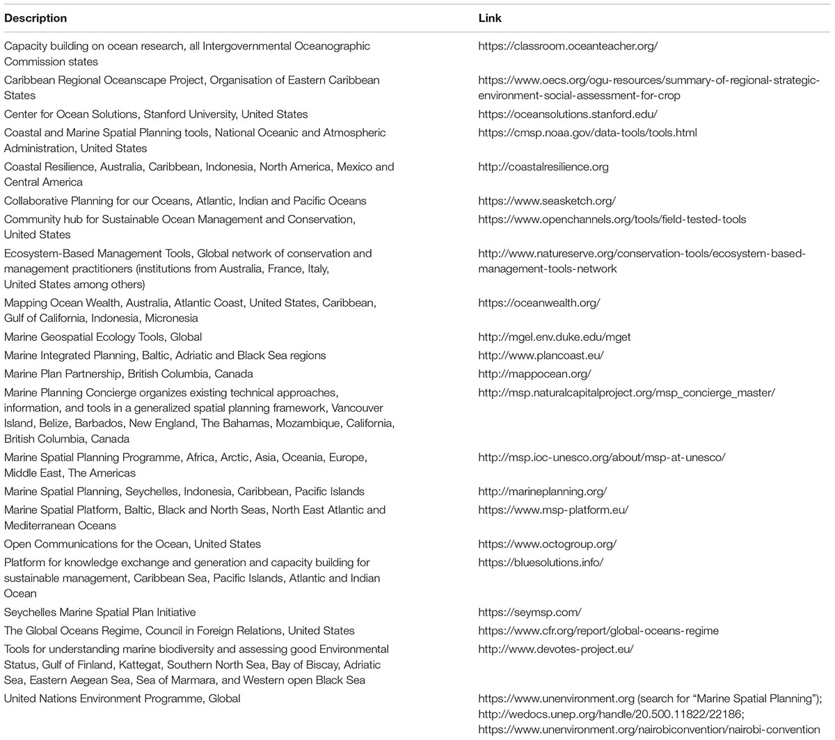
Table 1. A selection of online resources for MSP practitioners and researchers interested in multi-objective planning approaches and tools.
AL wrote the manuscript with case study inputs from co-authors. AL and NB were the leaders of the project and conceptualized the idea for research. JS provided strong conceptual input into the structure of the manuscript. NB, JS, SW, SL, KS, AJ, and ZK contributed to the manuscript study and provided the input for final editing. RT and HS contributed to the study led by JS and provided the input for final editing.
The authors declare that the research was conducted in the absence of any commercial or financial relationships that could be construed as a potential conflict of interest.
We thank the Marine Section of the Society for Conservation Biology for convening the Fourth International Marine Conservation Congress in St John’s, Newfoundland, Canada, in 2016, and the Fifth Congress in Kuching, Borneo, Malaysia, in 2018, at which we presented the studies described here and developed this collaboration. AL acknowledges the Department of Science and Technology and the National Research Foundation of South Africa for financial support to attend the IMCCs. NB acknowledges the Marine Environmental Observation, Prediction, and Response Network (MEOPAR), NSERC, SSHRC, and the University of Victoria. AJ acknowledges MEOPAR, the Central Coast Indigenous Resource Alliance, and Mitacs Canada. SW acknowledges funding from the Gordon and Betty Moore Foundation. SL acknowledges funding from NOAA SeaGrant/California SeaGrant and the Waitt Foundation. JS acknowledges funding from The Nature Conservancy. KS acknowledges the South African National Biodiversity Institute (SANBI) and the communities of practice convened by SANBI, funding provided through the African Coelacanth Ecosystem Program and the Foundational Biodiversity Information Programs of the National Research Foundation and the Pew Charitable Trusts.
Agostini, V. N., Margles, S. W., Knowles, J. K., Schill, S. R., Bovino, R. J., and Blyther, R. J. (2015). Marine zoning in St. Kitts and Nevis: a design for sustainable management in the Caribbean. Ocean Coast. Manag. 104, 1–10. doi: 10.1016/j.ocecoaman.2014.11.003
Arkema, K. K., Verutes, G., Bernhardt, J. R., Clarke, C., Rosado, S., Canto, M., et al. (2014). Assessing habitat risk from human activities to inform coastal and marine spatial planning: a demonstration in Belize. Environ. Res. Lett. 9:114016. doi: 10.1088/1748-9326/9/11/114016
Arkema, K. K., Verutes, G. M., Wood, S. A., Clarke-Samuels, C., Rosado, S., Canto, M., et al. (2015). Embedding ecosystem services in coastal planning leads to better outcomes for people and nature. PNAS 112, 7390–7395. doi: 10.1073/pnas.1406483112
Ban, N. C., Eckert, L., Mcgreer, M., and Frid, A. (2017). Indigenous knowledge as data for modern fishery management: a case study of dungeness crab in Pacific Canada. Ecosyst. Health Sustain. 3:1379887. doi: 10.1080/20964129.2017.1379887
Ban, N. C., Frid, A., Reid, M., Edgar, B., Shaw, D., and Siwallace, P. (2018). Incorporate indigenous perspectives for impactful research and effective management. Nat. Ecol. Evol. 2, 1680–1683. doi: 10.1038/s41559-018-0706-0
Beck, M. W., Ferdaña, Z., Kachmar, J., Morrison, K. K., and Taylor, P. (2009). Best Practices for Marine Spatial Planning. Arlington, VA: Nature Conservancy.
Bland, L. M., Keith, D. A., Miller, R. M., Murray, N. J., and Rodríguez, J. P. (2016). Guidelines for the Application of IUCN Red List of Ecosystems Categories and Criteria, Version 1.0. Gland: IUCN.
Bolman, B., Jak, R. G., and van Hoof, L. (2018). Unravelling the myth–The use of decisions support Systems in marine management. Mar. Policy 87, 241–249. doi: 10.1016/j.marpol.2017.10.027
Börger, T., Hattam, C., Burdon, D., Atkins, A. P., and Austen, M. A. (2014). Valuing conservation benefits of an offshore marine protected area. Ecol. Econ. 108, 229–241. doi: 10.1016/j.ecolecon.2014.10.006
Coastal Zone Management Authority and Institute [CZMAI] (2016). Belize Integrated Coastal Zone Management Plan. Belize: CZMAI.
Coetzee, J. C., Van der Lingen, C. D., Hutchings, L., and Fairweather, T. P. (2008). Has the fishery contributed to a major shift in the distribution of South African sardine? ICES J. Mar. Sci. 65, 1676–1688.
De Santo, E. M. (2013). Missing marine protected area (MPA) targets: how the push for quantity over quality undermines sustainability and social justice. J. Environ. Manag. 124, 137–146. doi: 10.1016/j.jenvman.2013.01.033
Department for Environment Food and Rural Affairs [DEFRA] and Joint Nature Conservation Committee (2011). Dogger Bank Special Area of Conservation Impact Assessment. United Kingdom: DEFRA.
Dunford, R. W., Ginn, T. C., and Desvousges, W. H. (2004). The use of habitat equivalency analysis in natural resource damage assessments. Ecol. Econ. 48, 49–70. doi: 10.1016/j.ecolecon.2003.07.011
Eckert, L., Ban, N. C., Frid, A., and Mcgreer, M. (2018). Diving back in time: extending historical baselines for yelloweye rockfish with indigenous knowledge. Aquat. Conserv. Mar. Freshw. Ecosyst. 28, 158–166. doi: 10.1002/aqc.2834
Ehler, C., and Douvere, F. (2009). Marine Spatial Planning: A Step-by-Step Approach Toward Ecosystem-Based Management. Intergovernmental Oceanographic Commission and Man and the Biosphere Programme. Paris: Unesco.
Elliott, M., and Cutts, N. D. (2004). Marine habitats- loss and gain, mitigation and compensation. Mar. Pollut. Bull. 49, 671–674. doi: 10.1016/j.marpolbul.2004.08.018
Fischer, T. B., Gazzola, P., Jha-Thakur, U., Belèáková, I., and Aschemann, R. (2008). Environmental Assessment Lecturers’ Handbook. Bratislava: ROAD.
Flores, N. E., and Thacher, J. (2002). Money, Who Needs It? Contemp. Econ. Policy 20, 171–178. doi: 10.1093/cep/20.2.171
Forest Trends and The Katoomba Group (2010). Payments for Ecosystem Services: Getting Started in Marine and Coastal Ecosystems: A Primer. Available at: http://www.foresttrends.org/publication_details.php?publicationID=2374 (accessed February 20, 2013).
Fox, E., Poncelet, E., Connor, D., Vasques, J., Ugoretz, J., McCreary, S., et al. (2013). Adapting stakeholder processes to region-specific challenges in marine protected area network planning. Ocean Coast. Manag. 74, 24–33. doi: 10.1016/j.ocecoaman.2012.07.008
GENECON (2014). Forewind LTD, Dogger Bank Offshore Wind Farm Economic Benefits Study Technical Paper. Available at: http://www.forewind.co.uk/uploads/GENECON_DBOWF_Technical%20Paper_CLEAN_FINALv2_130314.pdf (accessed October 10, 2018).
Gentry, R., Lester, S. E., Kappel, C. V., White, C., Bell, T. W., Stevens, J., et al. (2017). Offshore aquaculture: spatial planning principles for sustainable development. Ecol. Evol. 7, 733–743. doi: 10.1002/ece3.2637
Guerry, A. D., Ruckelshaus, M. H., Arkema, K. K., Bernhardt, J. R., Guannel, G., Kim, C. K., et al. (2012). Modeling benefits from nature: using ecosystem services to inform coastal and marine spatial planning. Int. J. Biodivers. Sci. Ecosyst. Serv. Manag. 8, 107–121. doi: 10.1080/21513732.2011.647835
Harris, L. R., Holness, S., Finke, G., Kirkman, S., and Sink, K. (2019). “Systematic conservation planning as a tool to advance ecologically or biologically significant area and marine spatial planning processes,” in Marine Spatial Planning – Past, Present, Future, eds K. Gee and J. Zaucha (Cham: Palgrave Macmillan), 71–96. doi: 10.1007/978-3-319-98696-8_4
Holden, J., Collicutt, B., Covernton, G., Cox, K. D., Lancaster, D., Dudas, S. E., et al. (2019). Synergies on the coast: challenges facing shellfish aquaculture development on the central and north coast of British Columbia. Mar. Policy 101, 108–117. doi: 10.1016/j.marpol.2019.01.001
Keeler, B. L., Wood, S. A., Polasky, S., Kling, C., Filstrup, C. T., and Downing, J. A. (2015). Recreational demand for clean water: evidence from geotagged photographs by visitors to lakes. Front. Ecol. Environ. 13:76–81. doi: 10.1890/140124
Kenchington, R. A., and Day, J. C. (2011). Zoning, a fundamental cornerstone of effective marine spatial planning: lessons learnt from the great barrier reef, Australia. J. Coast. Conserv. 15, 271–278. doi: 10.1007/s11852-011-0147-2
Kirkman, S. P., Holness, S., Harris, L. R., Sink, K. J., Lombard, A. T., Kainge, P., et al. (2019). Using systematic conservation planning to support marine spatial planning and achieve marine protection targets in the transboundary benguela ecosystem. Ocean Coast. Manag. 168, 117–129. doi: 10.1016/j.ocecoaman.2018.10.038
Kyriazi, Z., Lejano, R., Maes, F., and Degraer, S. (2015). Bargaining a net gain compensation agreement between a marine renewable energy developer and a marine protected area manager. Mar. Policy 60, 40–48. doi: 10.1016/j.marpol.2015.06.005
Kyriazi, Z., Lejano, R., Maes, F., and Degraer, S. (2016). A cooperative game-theoretic framework for negotiating marine spatial allocation agreements among heterogeneous players. J. Environ. Manag. 187, 444–455. doi: 10.1016/j.jenvman.2016.11.011
Lancaster, D. (2017). Developing Scallop and Geoduck Aquaculture on British Columbia’s Central Coast: Recommendations From Experts. Available at: http://www.aerinjacob.ca/uploads/1/0/5/5/10559030/lancaster__2017__recommendations_for_developing_shellfish_aquaculture_on_bc_central_coast.pdf doi: 10.1007/s002679900224 (accessed November 1, 2018).
Lejano, R., and Davos, C. (1999). Cooperative solutions for sustainable resource management. Environ. Manag. 24, 167–175. doi: 10.1007/s002679900224
Lester, S. E., Costello, C., Halpern, B. S., Gaines, S. D., White, C., and Barth, J. A. (2013). Evaluating trade-offs among ecosystem services to inform marine spatial planning. Mar. Policy 38, 80–89. doi: 10.1016/j.marpol.2012.05.022
Lester, S. E., Gentry, R. R., Kappel, C. V., White, C., and Gaines, S. D. (2018a). Opinion: offshore aquaculture in the United States: untapped potential in need of smart policy. Proc. Natl. Acad. Sci. U.S.A. 115, 7162–7165. doi: 10.1073/pnas.1808737115
Lester, S. E., Stevens, J. S., Gentry, R., Kappel, C. V., Bell, T. W., Costello, C., et al. (2018b). Marine spatial planning makes room for offshore aquaculture in crowded coastal waters. Nat. Commun. 9:945. doi: 10.1038/s41467-018-03249-1
Lombard, A. T., Dorrington, R. A., Ortega-Cisneros, K., Penry, G. S., Pichegru, L., Reed, J. R., et al. (2019). Key challenges in advancing an ecosystem-based approach to marine spatial planning under economic growth imperatives. Front. Mar. Sci. 6:146. doi: 10.3389/fmars.2019.00146
Lombard, A. T., Reyers, B., Schonegevel, L. Y., Cooper, J., Smith-Adao, L. B., Nel, D. C., et al. (2007). Conserving pattern and process in the southern ocean: designing a marine protected area for the prince edward Islands. Antarct. Sci. 19, 39–54.
Marine Plan Partnership for the North Pacific Coast [MAPP] (2016). MaPP Implementation Strategy 2015-2020. Available at: http://mappocean.org/wp-content/uploads/2016/12/MaPP_Implementation_Strategy_web_20161230.pdf (accessed November 4, 2018).
McKenzie, E., Posner, S., Tillmann, P., Bernhardt, J. R., Howard, K., and Rosenthal, A. (2014). Understanding the use of ecosystem service knowledge in decision making: lessons from international experiences of spatial planning. Environ. Plan. C Gov. Policy 32, 320–340. doi: 10.1068/c12292j
Mhlongo, N., Yemane, D., Hendricks, M., and van der Lingen, C. D. (2015). Have the spawning habitat preferences of anchovy (Engraulis encrasicolus) and sardine (Sardinops sagax) in the southern Benguela changed in recent years? Fish Oceanogr. 24, 1–14. doi: 10.1111/fog.12061
Pauly, D. (1995). Anecdotes and the shifting baseline syndrome of fisheries. Trends Ecol. Evol. 10:430. doi: 10.1016/S0169-5347(00)89171-5
Pınarbaşı, K., Galparsoro, I., Borja,Á, Stelzenmüller, V., Ehler, C. N., and Gimpel, A. (2017). Decision support tools in marine spatial planning: present applications, gaps and future perspectives. Mar. Policy 83, 83–91. doi: 10.1016/j.marpol.2017.05.031
Rassweiler, A., Costello, C., Hilborn, R., and Siegel, D. A. (2014). Integrating scientific guidance into marine spatial planning. Proc. R. Soc. B Biol. Sci. 281:20132252. doi: 10.1098/rspb.2013.2252
Rosenthal, A., Verutes, G., McKenzie, E., Arkema, K. K., Bhagabati, N., Bremer, L. L., et al. (2015). Process matters: a framework for conducting decision-relevant assessments of ecosystem services. Int. J. Biodivers. Sci. Ecosyst. Serv. Manag. 11, 190–204. doi: 10.1080/21513732.2014.966149
Roy, C., Van der Lingen, C. D., Coetzee, J. C., and Lutjeharms, J. R. E. (2007). Abrupt environmental shift associated with changes in the distribution of Cape anchovy Engraulis encrasicolus spawners in the southern Benguela. Afr. J. Mar. Sci. 29, 309–319. doi: 10.2989/AJMS.2007.29.3.1.331
Ruckelshaus, M., McKenzie, E., Tallis, H., Guerry, A., Daily, G., Kareiva, P., et al. (2015). Notes from the field: lessons learned from using ecosystem service to inform real-world decisions. Ecol. Econ. 115, 11–21. doi: 10.1016/j.ecolecon.2013.07.009
SANBI, and UNEP-WCMC. (2016). Mapping Biodiversity Priorities: A Practical, Science-Based Approach to National Biodiversity Assessment and Prioritisation to Inform Strategy and Action Planning. Cambridge: UNEP-WCMC.
Sink, K., Holness, S., Harris, L., Majiedt, P., Atkinson, L., Robinson, T., et al. (2012). National Biodiversity Assessment 2011. Technical report in Marine and Coastal Component, vol. 4, Pretoria, South African National Biodiversity Institute.
Sink, K. J. (2016). The marine protected areas debate: implications for the proposed phakisa marine protected areas network. S. Afr. J. Sci. 112, 9–10. doi: 10.17159/sajs.2016/a0179
Sink, K. J., Attwood, C. G., Lombard, A. T., Grantham, H., Leslie, R., Samaai, T., et al. (2011). Spatial Planning to Identify Focus Areas for Offshore Biodiversity Protection in South Africa. Final Report for the Offshore Marine Protected Area Project. Cape Town, South African National Biodiversity Institute.
Smith, J. L. (2017). “Options for adopting marine spatial planning,” in The Ocean Economy in Mauritius: Making it Happen, Making it Last, eds R. Cervigni and P. L. Scandizzo (Washington, DC: World Bank Group), 329.
Smith, J. L., Sims, H. E., and Tingey, R. (2018a). Draft Phase 1 Seychelles Marine Spatial Plan: MSP Marine Areas. Unpublished report to Government of Seychelles, 43. Available at: www.seymsp.com (accessed November 4, 2018).
Smith, J. L., Tingey, R., and Sims, H. E. (2018b). Seychelles Marine Spatial Plan Atlas. Report to Government of Seychelles, 95. Available at: www.seymsp.com (accessed November 4, 2018).
Verutes, G. V., Arkema, K. K., Clarke-Samuels, C., Wood, S. A., Rosenthal, A., Rosado, S., et al. (2017). Integrated planning that safeguards ecosystems and balances multiple objectives in coastal Belize. Int. J. Biodivers. Sci. Ecosyst. Serv. Manag. 13, 1–17.
Wood, S. A., Guerry, A. D., Silver, J. M., and Lacayo, M. (2013). Using social media to quantify nature-based tourism and recreation. Sci. Rep. 3:2976. doi: 10.1038/srep02976
World Travel and Tourism Council [WTTC] (2017). Travel & Tourism Economic Impact 2017 – March. Published by World Tourism and Travel Council. 20. Available at: www.wttc.org/-/media/files/reports/economic-impact-research/ countries-2017/seychelles2017.pdf (accessed November 4, 2018).
Yates, K. L., Schoeman, D. S., and Klein, C. J. (2015). Ocean zoning for conservation, fisheries and marine renewable energy: assessing trade-offs and co-location opportunities. J. Environ. Manag. 152, 201–209. doi: 10.1016/j.jenvman.2015.01.045
Keywords: ocean zoning, marine conservation, trade-offs, decision support, scenario planning, ecosystem services, integrated ocean management
Citation: Lombard AT, Ban NC, Smith JL, Lester SE, Sink KJ, Wood SA, Jacob AL, Kyriazi Z, Tingey R and Sims HE (2019) Practical Approaches and Advances in Spatial Tools to Achieve Multi-Objective Marine Spatial Planning. Front. Mar. Sci. 6:166. doi: 10.3389/fmars.2019.00166
Received: 08 November 2018; Accepted: 15 March 2019;
Published: 05 April 2019.
Edited by:
E. Christien Michael Parsons, University of Glasgow, United KingdomReviewed by:
Karen Nadine Scott, University of Canterbury, New ZealandCopyright © 2019 Lombard, Ban, Smith, Lester, Sink, Wood, Jacob, Kyriazi, Tingey and Sims. This is an open-access article distributed under the terms of the Creative Commons Attribution License (CC BY). The use, distribution or reproduction in other forums is permitted, provided the original author(s) and the copyright owner(s) are credited and that the original publication in this journal is cited, in accordance with accepted academic practice. No use, distribution or reproduction is permitted which does not comply with these terms.
*Correspondence: Amanda T. Lombard, bWFuZHkubG9tYmFyZEBtYW5kZWxhLmFjLnph
†Present address: Aerin L. Jacob, Yellowstone to Yukon Conservation Initiative, Canmore, AB, Canada
Disclaimer: All claims expressed in this article are solely those of the authors and do not necessarily represent those of their affiliated organizations, or those of the publisher, the editors and the reviewers. Any product that may be evaluated in this article or claim that may be made by its manufacturer is not guaranteed or endorsed by the publisher.
Research integrity at Frontiers
Learn more about the work of our research integrity team to safeguard the quality of each article we publish.