 Jordi Diaz
 Martin Schimmel
 Mario Ruiz
94% of researchers rate our articles as excellent or good
Learn more about the work of our research integrity team to safeguard the quality of each article we publish.
Find out more
PERSPECTIVE article
Front. Earth Sci. , 05 February 2020
Sec. Solid Earth Geophysics
Volume 8 - 2020 | https://doi.org/10.3389/feart.2020.00009
This article is part of the Research Topic The Power of Citizen Seismology: Science and Social Impacts View all 16 articles
The high degree of human activities in urban environments produces large background vibrations that makes it difficult to use data acquired in these areas for classical seismology. Seismometers installed within cities have been typically been used for the study of seismic hazard or for monitoring civil engineering problems. However, with the development of monitoring techniques based on the interpretation of the so-called seismic ambient noise, these data have gained scientific interest. Our objective is to discuss an additional utility of seismometers deployed within a city; its use as a tool to connect society with Earth sciences. Many citizen activities, from traffic to music concerts, produce vibrations that can be recorded seismically, and our experience shows that these records attract the attention of the media and social networks. With the emergence of low-cost and easy-to-use instruments in recent years, more citizens can now record ground motion and become interested in the interpretation of the recorded seismograms. The installation of permanent seismic networks in educational centers has proven to be a good approach to introduce students to Earth sciences at the national level and can also be developed at the urban scale using this new instrumentation. In this contribution we will first review the previous results related to the identification of the sources of vibration in urban areas and then present a new ongoing project based on the deployment of a seismic network in educational centers located in the city of Barcelona.
The high degree of human activities in urban environments results in a large level of background vibrations that often mask the arrival of seismic waves originated by earthquakes. Therefore, classical seismology, based on the identification of such waves, is difficult to achieve in urban environments. Most of the seismic recordings within cities are focused on refining the hazard maps used for risk assessment, typically using techniques as the microtremor horizontal to vertical spectral ratio to obtain the characteristic frequency of each site and hence characterize the subsoil. With the emergence of monitoring techniques based on the interpretation of the vibrations recorded in absence of earthquakes (Campillo and Paul, 2003), often referred as ambient noise, seismic records in noisy environments as cities have gained scientific interest, although the applicability of these methods in urban areas remains an open question.
In this contribution we will focus on a complementary use of seismic deployments in urban environments, directly related to the concept of “citizen science.” The idea is to involve the secondary school community in the recording and interpretation of seismic data acquired within cities. Previous results have shown that many citizen activities produce vibrations that can be recorded seismically, including traffic (Riahi and Gerstoft, 2015), subway systems (Sheen et al., 2009), music concerts (Green and Bowers, 2008) or football games (Díaz et al., 2017). The identification of the vibrations generated by this kind of sources is useful to correctly interpret ambient noise data, but also to attract the attention of mass media (journals, radio, TV) and social networks and be used as a valuable tool for spreading news related to seismology and, in general, Earth sciences to the main public. The emergence of low cost seismic instruments connected to the global network has resulted in a densification of instruments installed in or near urban areas and the involvement of a significant number of amateur seismologists. This new community is an opportunity to create citizen seismological networks whose results could be used for scientific purposes, besides of attracting the interest of the youngest generation toward seismological research. We will first review the sources of ground vibration in urban areas and then present a new ongoing project based on the deployment of a seismic network in educational centers located in the city of Barcelona, that is expected to provide more information on the identification of such kind of sources.
Since the early 2000s, several seismic networks have been deployed with the aim of investigating the uppermost crust using ambient seismic noise. Methods based on spatial autocorrelation of seismic data (SPAC, e.g., Okada, 2006) or on the analysis of the microtremor horizontal to vertical spectral ratio (MHVSR. e.g., Molnar et al., 2018) are widely used for site characterization. MHVSR is based on short-term recordings at multiple sites and usually does not take into consideration the origin of the recorded vibrations. In the last decades, seismic arrays acquiring data for periods of several weeks to months have been deployed in different cities. We can highlight the pioneering work carried out in Bucharest, where around 30 stations were deployed in the early 2000s to map the dominant sources of noise (Groos and Ritter, 2009) and investigate the uppermost shear wave velocity structure (Manea et al., 2016). A particular case is the deployment of 5200 sensors spaced 100 m away in the city of Long Beach (California, United States). The acquired data have proven that high resolution shear velocity structure can be recovered using ambient noise tomography in areas with high human activity (Lin et al., 2013). With regard to noise sources, road traffic and train transportation systems are the main contributors, although other moving sources, as aircraft departing and landing have also been identified (Riahi and Gerstoft, 2015). A recent work in the Benevento city (S. Italy) using accelerometers, short period and broad band stations has shown that the analysis of seismic noise using a small aperture array is a valid tool for subsurface characterization in urban areas even if using only a limited number of stations (Vassallo et al., 2019).
The biggest source of vibrations in urban areas are the road traffic and the train and subway transport systems. However, several other sources, both from natural and anthropogenic origin, are recorded regularly and their identification is often possible based on the spectral properties of the signals. Figure 1 illustrates some examples of seismic signals recorded at different stations located within the city of Barcelona. Figure 1A shows the envelope of the vertical component of the seismic signal recorded at a station installed in the Monestir of Pedralbes, a monastery still in operation located at only 50 m of a subterranean section of the Barcelona ring road. This site was operated during one month to monitor the activity of this road as part of a documentary for a television network. The figure shows the vertical component of the seismic data, filtered between 8 and 12 Hz, during a period of 16 days (18th February–6th March 2017). Seismic energy at frequencies around 10 Hz is clearly related to the road traffic activity, as shown by its temporal changes in amplitude. Day/night and working day/week-end variations are easily identified in the data. Rush hours during business days appear in the morning and in the afternoon, but also around noon, as a large number of schools are located near this area and some of the students come back at home during lunch time. Figure 2B shows an example of the second major source of vibrations typically recorded within large cities, those induced by subway transport systems. The image reproduces the vertical component of the seismic record and the corresponding spectrogram for the BAIN accelerometric station, part of the ICGC network and installed in the center of Barcelona. The time variations in amplitude follow narrowly the operating times of the subway system, that runs between 5 am and 12 pm on business days, between 5 am and 2 am on Fridays and the 24 h between Saturdays and Sundays. The subway signal can be observed between 2 and 100 Hz, with highest amplitude in the 20–50 Hz band. Figure 1C shows an example of vibrations of natural origin recorded within the city. The seismic data in the 4–9 Hz band clearly shows the record of a short but heavy rainfall event the 15th November 2018. Returning to vibrations of man-made origin, Figure 1D presents the seismic signal recorded during the passage of the Barcelona marathon runners near the ICJA seismic station. The energy is concentrated in a narrow frequency band around 2.8 Hz, equivalent to 170 steps per minute, a typical pace for marathon runners. A careful inspection of the data shows that the first runners follow a higher pace than the rest of participants, as expected for sport events mixing professional and popular runners. Finally, Figure 1E shows a particular type of vibration recorded at the ICJA station, located at about 500 m of the FC Barcelona football stadium. The celebration of Barça fans after Messi’s goals during a Champions League match between FC Barcelona and Liverpool FC are clearly recorded on the seismometer, spanning the seismic spectra between 2 and 7 Hz.
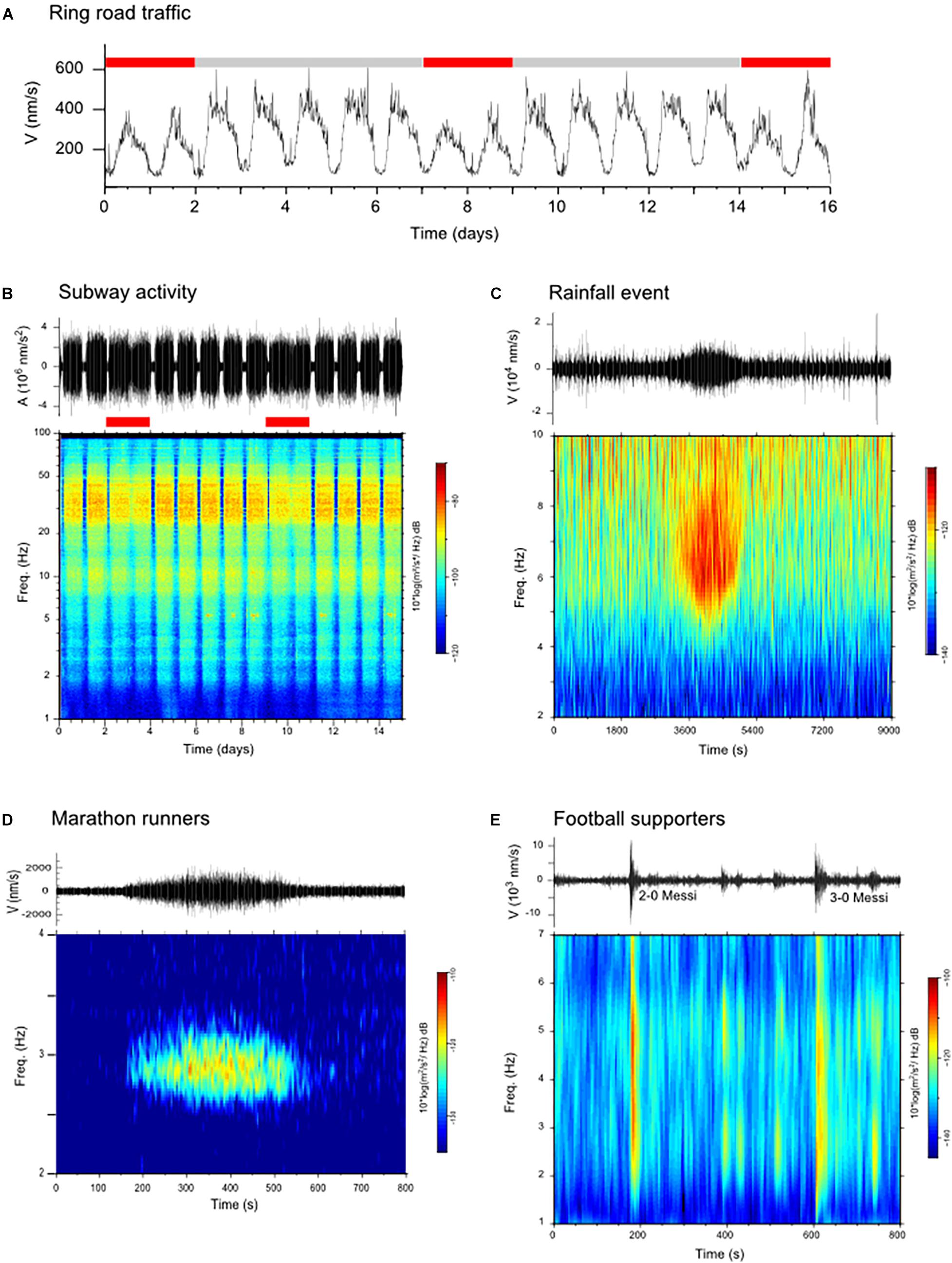
Figure 1. Examples of non-tectonic seismic signals recorded in urban environments. (A) Envelope of the vertical seismic component at a site close to the Barcelona ring road, filtered between 4 and 12 Hz and decimated to six samples per hour. Red and gray bars show week-end and business days (18/2/2017–6/3/2017). (B) Vertical component and spectrogram for the CA. BAIN accelerometric station, installed in central Barcelona, showing the activity of the subway system. Week-end days are marked by red bars (1/11/2018–16/11/2018). (C) Seismic data (filtered between 4 and 8 Hz) and spectrogram recorded at CA. ICJA during a heavy rainfall event the 15/11/2018. (D) Seismic record (filtered between 2.4 and 3.4 Hz) and spectrogram of the passage of the Barcelona Marathon runners near the CA. ICJA seismic station (11/3/2018). (E) Seismic record at the CA. ICJA station during the FCB-Liverpool Champions League match (1/5/2019), showing the shaking generated by the supporters celebration of Messi’s goals.
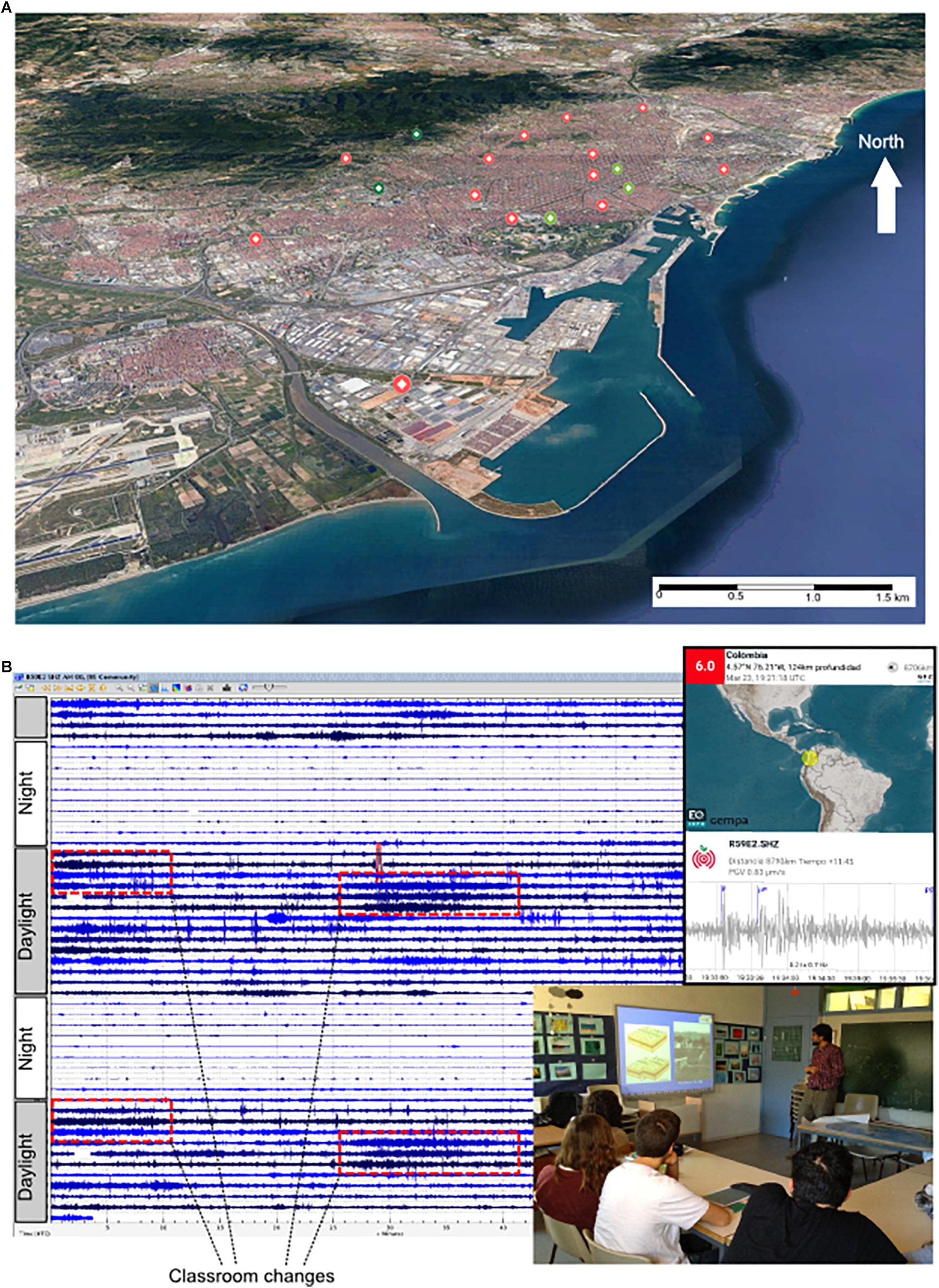
Figure 2. Deployment of seismic stations in secondary schools. (A) Map view of the seismic stations deployed in secondary schools within the Barcelona area. Red dots show the newly deployed stations, while light and dark green dots show the available broad-band and accelerometric stations. (B) Example of seismic records in a secondary school in Barcelona (1 h per line) clearly showing the day/night variations and the scholar activity pattern; red dashed boxes show the 5 min-long periods of larger noise observed every hour during classroom changes. The upper side panel shows an example of the seismic alerts that can be received by the students using mobile phone apps, while the lower side panel illustrates the dissemination talks given in schools.
The identification of the noise sources and their spatial distribution is of great interest to correctly process and interpret the ambient noise data. The seismic waves generated by these sources travel through the shallow subsoil and, depending on their characteristics, can be used with different analysis techniques to study the seismic structure beneath pavements and buildings.
Seismic networks installed in educational centers have been developed throughout the world during the last decades. Some of the most successful examples are the different educational networks integrated in the project “Seismographs in school,” promoted by the Incorporated Research Institutions for Seismology (IRIS) in the United States1, the United Kingdom “Schools Seismology Network” administered by the British Geological Survey2, the Australian AuSIS network3, the french “Sismo à l’école” projects4 or the “Seismology in Schools” project managed by the Dublin Institute for Advanced Studies (DIAS) in Ireland5. These initatives have proven to be useful for connecting the students to Earth sciences, in particular in regions with moderate levels of seismic activity (e.g., Courboulex et al., 2012; Balfour et al., 2014). Data from some of these networks are nowadays distributed through the FDSNW service following the same protocol than for scientific networks.
In this contribution we want to present a new initiative carried out in Spain as part of a research project founded by the Spanish Ministry of Science, Research and Innovation. This network, installed during November 2019, has the particularity of having a high resolution scale, since it covers an area of approximately 10 km2 within the city of Barcelona with 14 temporary stations and integrating the five permanent sites already on duty. Twelve of the temporary sites have been installed in the premises of secondary schools, seeking to involve educational centers in the city to participate in the project. In return, students in those centers will be trained in the use of seismic instruments and the first analysis of the data. The objective is to close the gap between educational and research objectives, as the project aims to promote the knowledge on seismology and Earth Science among secondary school students, but also acquire data of scientific interest to investigate the feasibility of ambient noise studies in urban environments. The same project includes also the deployment of broad-band stations and high-resolution nodes in the eastern Pyrenees, to analyze the subsoil with similar methods but in a calmer environment.
Figure 2A shows a map view of the seismic stations that have been deployed in Barcelona. Red dots mark the new stations, while light and dark green dots show the available broad-band and accelerometric stations. The geometry of the network has been chosen to sample the main geological units of the Barcelona area. The network, expected to remain operative until the summer 2020, benefits from both professional three component short period instruments and one-component RaspberryShake (RS) seismometers equipped with 4.5 Hz6. It is planned that both kind of instruments will cover each site in different time periods to benefit from their respective advantages. Professional seismometers provide high quality data, but are difficult to be accessed in real time due to limitations in internet connectivity implemented in most educational centers for security reasons. The RS instruments have been designed to avoid these problems by transmitting the recorded data to an external data management center, an approach that makes easier the data collection for scientific objectives. However, as the data are sent through the network, they are more likely to contain gaps that can make it difficult to apply seismic methods based on the analysis of ambient seismic noise. It can be noted that RS instruments have been compared with geophones in field experiments with good results (Anthony et al., 2018).
With respect to the educational objectives of the project, the underlying idea is to use of the fascination power of earthquakes to introduce students in Earth Sciences and stimulate their motivation to continue learning using the multiple tools available online. Our experience shows that students are attracted to directly see how the waves from distant earthquakes shake the school building in a detectable way, a fact that seems obvious to Earth scientists, but that is surprising to people without training in this field. More generally, students will be introduced to the development of a research project, from its initial planning to the final presentation of the obtained results.
During the deployment of the seismometer in the secondary schools, an introductory talk is given to the students (Figure 2B), with the main objective of increasing their curiosity about issues related to seismology and, in particular, how seismic waves are recorded and what information can be retrieved from their study. The research team has a long tradition in dissemination projects, because since 2009 it has been regularly offering a workshop named “Looking for Earthquakes” to secondary schools in and around Barcelona. This introductory talk is complemented in this case by a hands-on session in which the data acquired in each school are inspected. Students first notice the day/night and business day/weekend variations of the background noise, as well as the noise variations directly related to the scholar activity; e.g., the intervals of about 5 min of higher amplitude correspond to the classroom changes that students usually make every hour (Figure 2B). These observations can be used to develop students’ abilities to read and interpret graphs, propose hypotheses to explain the data and seek additional information to validate or not the hypothesis. Students can also investigate aspects directly related to Earth sciences, as the distribution and rate of occurrence of earthquakes, their relationship with plate tectonics, the concepts of intensity and magnitude and the aspects related to seismic hazards, all of them elements included in the official curricula. The students are invited to use phone apps as EqInfo7, which allow them to track in real time seismic detections in the network stations (Figure 2B). The research team will support the centers most committed to the project with guidance and appropriate software tools so that students can locate earthquakes and study the propagation of seismic waves.
The degree of involvement of each school will vary depending on their respective pedagogical plans. For example, the installation of the seismic network can be used to implement transversal educational projects that involve not only the natural sciences, but also physics, technology, and even social sciences. Seismometers can be used to study the pendulum laws, electromagnetic induction, elastic wave propagation or frequency analyses. The network can also be a motivation to develop technological projects with the objective of designing in-house seismometers based in existent and affordable elements and to develop programing exercises for processing the recorded data. Finally, aspects related to social sciences, including the economic aspects of seismic risk or the historical interest of the most reputed philosophers in the origin of earthquakes and the Earth internal structure can also be addressed. The scientific team will provide support to the centers that decide to carry out this type of initiatives.
With respect to the scientific objective of the Barcelona scholar seismic network, the acquired data will be first used to map in detail the sources of vibrations around the city, an information that is relevant to check its applicability for tomographic investigations (e.g., Yang and Ritzwoller, 2008). The data will be used to verify and expand the MHVSR studies already available in the Barcelona zone (Cadet et al., 2011 and references therein). Having continuous records for several months will make it possible to verify whether temporal variations in background noise can affect the MHVSR measurements. Salinas et al. (2014) have already pointed that f0 resonance peaks retrieved from MHVSR studies can vary strongly between very close sites and Macau et al. (2015) have also observed that some locations in the Barcelona conurbation present two HVSR peaks, which makes it difficult to determine what the representative value for engineering studies is.
Finally, we plan to use also the data to test the applicability of the methods based on Rayleigh wave ellipticity inversion (e.g., Berbellini et al., 2019) and ambient noise tomography (e.g., Nuñez et al., 2019) in an urban environment. Since the noise tomography approach relies on a diffusive noise wave field, that is, without directivity, it is not clear whether or how well it can be used in an active environment such as Barcelona. However, the characterization of the sources discussed previously may help to select appropriate time windows and hence allow to extract inter-station surface wave Green’s functions as required for the tomographic images of the shallow structure beneath Barcelona. Although the viability of such approaches is medium/low, if the data allows to obtain tomographic images on the subsurface levels below a city, this will have a high impact in hazard and risk assessment. Therefore, this task can be considered as a high risk/high impact study.
Although the most obvious way to involve citizen to Earth sciences is to share information about the local effects of natural seismicity, other forms of involvement can be explored. We propose here to focus the attention on secondary schools students by installing seismometers in their centers and involve the students in their management, with the ultimate goal of developing their curiosity about the sources of the recorded vibrations and, in general, providing hypotheses to explain data.
We are convinced that this can be a positive approach to increase the interest of society toward Earth sciences, in particular in countries not often affected by large earthquakes. The presence of Earth sciences in the curricula of secondary education has been decreasing in recent years in Spain and we believe it is urgent to promote actions to attract students’ attention to this field.
Our experience has shown that we can have a relatively high impact on social networks (Twitter, Facebook, Instagram) and mass media by unraveling and making the public aware that seismic sensors can detect activities such as traffic, subway trains or citizen activities as football games, music concerts or fireworks. We believe that attracting the attention of the public is of maximum interest for the future of our research field.
In addition to these aspects related to dissemination, we expect that data obtained by citizen networks installed in educational centers within the city of Barcelona can be useful from a scientific point of view, as the characterization of the sources of background vibrations in urban environments is of great interest to study the seismic structure beneath pavements and buildings using ambient noise data and hence make possible a better imaging of the geology beneath the city and an improving of the available seismic hazard maps.
The datasets analyzed for this study can be found in the ORFEUS Data Center (http://www.orfeus-eu.org/fdsnws/dataselect/1/) and in the Institut Cartográfic i Geológic de Catalunya repository (http://ws.icgc.cat/fdsnws/dataselect/1/).
JD, MS, MR, and RC contributed to the conception and design of the project. MR organized the database of the seismic data. JD wrote the first draft of the manuscript and figures. All authors contributed to manuscript revision, read and approved the submitted version.
This is a contribution of the SANIMS project (RTI2018-095594-B-I00), funded by the Spanish Ministry of Science, Innovation and Universities, with additional support from the Generalitat de Catalunya grant 2017SGR1022.
The authors declare that the research was conducted in the absence of any commercial or financial relationships that could be construed as a potential conflict of interest.
Anthony, R. E., Ringler, A. T., Wilson, D. C., and Wolin, E. (2018). Do low-cost seismographs perform well enough for your network? An overview of laboratory tests and field observations of the OSOP raspberry shake 4D. Seis. Res. Lett. 90, 219–228. doi: 10.1785/0220180251
Balfour, N. J., Salmon, M., and Sambridge, M. (2014). The Australian seismometers in schools network: education, outreach research, and monitoring. Seismol. Res. Lett. 85, 1063–1068. doi: 10.1785/0220140025
Berbellini, A., Schimmel, M., Ferreira, A. M. G., and Morelli, A. (2019). Constraining S -wave velocity using Rayleigh wave ellipticity from polarization analysis of seismic noise. Geophys. J. Int. 216, 1817–1830. doi: 10.1093/gji/ggy512
Cadet, H., Macau, A., Benjumea, B., Bellmunt, F., and Figueras, S. (2011). From ambient noise recordings to site effect assessment: the case study of Barcelona microzonation. Soil Dyn. Earthq. Eng. 31, 271–281. doi: 10.1016/j.soildyn.2010.07.005
Campillo, M., and Paul, A. (2003). Long range correlations in the diffuse seismic coda. Science 299, 547–549. doi: 10.1126/science.1078551
Courboulex, F., Berenguer, J. L., Tocheport, A., Bouin, M. P., Calais, E., Esnault, Y., et al. (2012). Sismos à l’Ecole: a worldwide network of real-time seismometers in schools. Seismol. Res. Lett. 83, 870–873. doi: 10.1785/0220110139
Díaz, J., Ruiz, M., Sánchez-Pastor, P. S., and Romero, P. (2017). Urban seismology: on the origin of earth vibrations within a city. Sci. Rep. 7:15296. doi: 10.1038/s41598-017-15499-y
Green, D. N., and Bowers, D. (2008). Seismic raves: tremor observations from an electronic dance music festival. Seismol. Res. Lett. 79, 546–553. doi: 10.1785/gssrl.79.4.546
Groos, J. C., and Ritter, J. R. R. (2009). Time domain classification and quantification of seismic noise in an urban environment. Geophys. J. Int. 179, 1213–1231. doi: 10.1111/j.1365-246x.2009.04343.x
Lin, F., Li, D., Clayton, R. W., and Hollis, D. (2013). High-resolution 3D shallow crustal structure in Long Beach, California: application of ambient noise tomography on a dense seismic array. Geophysics 78, Q45–Q56. doi: 10.1190/geo2012-0453.1
Macau, A., Benjumea, B., Gabàs, A., Figueras, S., and Vilà, M. (2015). The effect of shallow quaternary deposits on the shape of the H/V spectral ratio. Surv. Geophys. 36, 185–208. doi: 10.1007/s10712-014-9305-z
Manea, E. F., Michel, C., Poggi, V., and Donat, F. (2016). Improving the shear wave velocity structure beneath Bucharest (Romania) using ambient vibrations. Geophys. J. Int. 207, 848–861. doi: 10.1093/gji/ggw306
Molnar, S., Cassidy, J. F., Castellaro, S., Cornou, C., Crow, H., Hunter, J. A., et al. (2018). Application of Microtremor Horizontal-to-Vertical Spectral Ratio (MHVSR) analysis for site characterization: state of the art. Surv. Geophys. 39, 613–631. doi: 10.1007/s10712-018-9464-4
Nuñez, E., Schimmel, M., Stich, D., and Iglesias, A. (2019). Crustal velocity anomalies in costa rica from ambient noise tomography. Pure Appl. Geophys. 1–20. doi: 10.1007/s00024-019-02315-z
Okada, H. (2006). Theory of efficient array observations of microtremors with special reference to the SPAC method. Explor. Geophys. 37, 73–85. doi: 10.1071/eg06073
Riahi, N., and Gerstoft, P. (2015). The seismic traffic footprint: tracking trains, aircraft, and cars seismically. Geophys. Res. Lett. 42, 2674–2681. doi: 10.1002/2015gl063558
Salinas, V., Caselles, J. O., Pérez-Gracia, V., Santos-Assunçao, S., Clapes, J., Pujades, L. G., et al. (2014). Nanozonation in dense cities: testing a combined methodology in Barcelona City (Spain). J. Earthq. Eng. 18, 90–112. doi: 10.1080/13632469.2013.841601
Sheen, D. H., Shin, J. S., Kang, T. S., and Baag, C. E. (2009). Low frequency cultural noise. Geophys. Res. Lett. 36, 1–5. doi: 10.1029/2009GL039625
Vassallo, M., De Matteis, R., Bobbio, A., Di Giulio, G., Adinolfi, G. M., Cantore, L., et al. (2019). Seismic noise cross-correlation in the urban area of Benevento city (Southern Italy). Geophys. J. Int. 217, 1524–1542. doi: 10.1093/gji/ggz101
Keywords: urban seismology, seismic ambient noise, secondary schools, sources of ground vibrations, subsoil imaging
Citation: Diaz J, Schimmel M, Ruiz M and Carbonell R (2020) Seismometers Within Cities: A Tool to Connect Earth Sciences and Society. Front. Earth Sci. 8:9. doi: 10.3389/feart.2020.00009
Received: 19 November 2019; Accepted: 17 January 2020;
Published: 05 February 2020.
Edited by:
Remy Bossu, European-Mediterranean Seismological Centre, FranceReviewed by:
Aurelien Dupont, Commissariat à l’Énergie Atomique et aux Énergies Alternatives (CEA), FranceCopyright © 2020 Diaz, Schimmel, Ruiz and Carbonell. This is an open-access article distributed under the terms of the Creative Commons Attribution License (CC BY). The use, distribution or reproduction in other forums is permitted, provided the original author(s) and the copyright owner(s) are credited and that the original publication in this journal is cited, in accordance with accepted academic practice. No use, distribution or reproduction is permitted which does not comply with these terms.
*Correspondence: Jordi Diaz, amRpYXpAaWN0amEuY3NpYy5lcw==
Disclaimer: All claims expressed in this article are solely those of the authors and do not necessarily represent those of their affiliated organizations, or those of the publisher, the editors and the reviewers. Any product that may be evaluated in this article or claim that may be made by its manufacturer is not guaranteed or endorsed by the publisher.
Research integrity at Frontiers
Learn more about the work of our research integrity team to safeguard the quality of each article we publish.